Texas Winter 2018-2019

Winter Weather Discussion

Moderator: S2k Moderators

Forum rules

The posts in this forum are NOT official forecast and should not be used as such. They are just the opinion of the poster and may or may not be backed by sound meteorological data. They are NOT endorsed by any professional institution or STORM2K.

Help Support Storm2K
Message
Author
User avatar
spencer817
Tropical Storm
Tropical Storm
Posts: 197
Age: 26
Joined: Thu Nov 17, 2016 3:22 pm
Location: Coppell, TX

Re: Texas Winter 2018-2019

#2021 Postby spencer817 » Mon Dec 31, 2018 9:14 pm

spencer817 wrote:
spencer817 wrote:0z NAM has some light freezing rain in the metro tuesday afternoon, not a bad start. :D


DFW at 33 at 09z on wednesday, gonna be close this run.


Hour 39 heavy freezing rain in DFW :double:

HEAVIEST BANDING IN NW DALLAS COUNTY HAHA I HOPE SO :lol: 8-)
0 likes   
I'm going to go to school for this stuff :P

User avatar
Ntxw
Storm2k Moderator
Storm2k Moderator
Posts: 22793
Joined: Wed Oct 21, 2009 6:34 pm
Location: DFW, Texas

Re: Texas Winter 2018-2019

#2022 Postby Ntxw » Mon Dec 31, 2018 9:20 pm

TheProfessor wrote:
Brent wrote:
TheProfessor wrote::uarrow: Yep, however it's been evident that the heat island is affecting some of the models, could make a big difference in a setup like this.


Yeah i mean if DFW sees mostly rain(again) then obviously something is affecting it lol


I don't think the UHI will be to blame for warmer temps. It will likely be because WAA makes it too warm at the surface.


Heat island isn't to blame when it comes to warm or cold enough as the process happens thousands of feet up and air masses that move thousands of miles from one place to the other. Heat island is at the very lower tiny part of the existing air colum. It can effect whether or not frozen precip sticks vs a rural (obviously warmer in the cities) but it doesn't play much if any role at all whether the column supports, rain, snow, or ice.

Heat Island's role is mostly confined to temperature differential readings during daytime surface heating, and or nighttime cooling relative to another location that doesn't experience much of it.
2 likes   
The above post and any post by Ntxw is NOT an official forecast and should not be used as such. It is just the opinion of the poster and may or may not be backed by sound meteorological data. It is NOT endorsed by any professional institution including Storm2k. For official information, please refer to NWS products.

  Help support Storm2K!
Help Support Storm2K

Jarodm12
Category 1
Category 1
Posts: 337
Joined: Sat Jan 29, 2011 8:05 pm

Re: Texas Winter 2018-2019

#2023 Postby Jarodm12 » Mon Dec 31, 2018 9:23 pm

Unfortunately big shift with the moisture s/e at 45 it almost looks over
0 likes   

User avatar
bubba hotep
S2K Supporter
S2K Supporter
Posts: 5837
Joined: Wed Dec 28, 2016 1:00 am
Location: Collin County Texas

Re: Texas Winter 2018-2019

#2024 Postby bubba hotep » Mon Dec 31, 2018 9:24 pm

00z 12K NAM is a tad colder across DFW with the initial rain but it is torching above the surface. It would be hard to get any accumulation with temps from 32-30F given how warm the air is aloft.
1 likes   
Winter time post are almost exclusively focused on the DFW area.

User avatar
bubba hotep
S2K Supporter
S2K Supporter
Posts: 5837
Joined: Wed Dec 28, 2016 1:00 am
Location: Collin County Texas

Re: Texas Winter 2018-2019

#2025 Postby bubba hotep » Mon Dec 31, 2018 9:28 pm

Jarodm12 wrote:Unfortunately big shift with the moisture s/e at 45 it almost looks over


Any snow for DFW probably wouldn't happen until Thursday afternoon or night. There might be some freezing rain with the first wave of precipitation but real accumulations of sleet/snow wouldn't be until later, if at all.
3 likes   
Winter time post are almost exclusively focused on the DFW area.

Captmorg70
Tropical Storm
Tropical Storm
Posts: 181
Age: 37
Joined: Mon Dec 18, 2017 12:07 am
Location: Ponder Tx

Re: Texas Winter 2018-2019

#2026 Postby Captmorg70 » Mon Dec 31, 2018 9:31 pm

bubba hotep wrote:
Jarodm12 wrote:Unfortunately big shift with the moisture s/e at 45 it almost looks over


Any snow for DFW probably wouldn't happen until Thursday afternoon or night. There might be some freezing rain with the first wave of precipitation but real accumulations of sleet/snow wouldn't be until later, if at all.


What site are you using for the 00z suite? Looks like TT may not be updating tonight with a server merge planned
0 likes   

Lagreeneyes03
Category 2
Category 2
Posts: 558
Joined: Mon Dec 09, 2013 10:53 am
Location: Luxurious Lake Grapevine

Re: Texas Winter 2018-2019

#2027 Postby Lagreeneyes03 » Mon Dec 31, 2018 9:32 pm

Captmorg70 wrote:
bubba hotep wrote:
Jarodm12 wrote:Unfortunately big shift with the moisture s/e at 45 it almost looks over


Any snow for DFW probably wouldn't happen until Thursday afternoon or night. There might be some freezing rain with the first wave of precipitation but real accumulations of sleet/snow wouldn't be until later, if at all.


What site are you using for the 00z suite? Looks like TT may not be updating tonight with a server merge planned


Wow when did this become a Thursday afternoon/evening event? I thought it was all Wednesday afternoon/eve/night/Thur AM
3 likes   
I'm a Princess, not a forecaster.

Ralph's Weather
S2K Supporter
S2K Supporter
Posts: 3270
Age: 38
Joined: Fri Dec 13, 2013 11:55 am
Location: Lindale, TX
Contact:

Re: Texas Winter 2018-2019

#2028 Postby Ralph's Weather » Mon Dec 31, 2018 10:05 pm

Lagreeneyes03 wrote:
Captmorg70 wrote:
bubba hotep wrote:
Any snow for DFW probably wouldn't happen until Thursday afternoon or night. There might be some freezing rain with the first wave of precipitation but real accumulations of sleet/snow wouldn't be until later, if at all.


What site are you using for the 00z suite? Looks like TT may not be updating tonight with a server merge planned


Wow when did this become a Thursday afternoon/evening event? I thought it was all Wednesday afternoon/eve/night/Thur AM


The upper low is further south and slower.
2 likes   
Follow on Facebook at Ralph's Weather.

User avatar
EnnisTx
S2K Supporter
S2K Supporter
Posts: 896
Joined: Sat Dec 26, 2015 4:06 pm
Location: Albany, Texas
Contact:

Re: Texas Winter 2018-2019

#2029 Postby EnnisTx » Mon Dec 31, 2018 10:05 pm

Early Happy New Year!
My old butt is dragging, don't know that I'll make it to Midnight..... :eek:
6 likes   

User avatar
bubba hotep
S2K Supporter
S2K Supporter
Posts: 5837
Joined: Wed Dec 28, 2016 1:00 am
Location: Collin County Texas

Re: Texas Winter 2018-2019

#2030 Postby bubba hotep » Mon Dec 31, 2018 10:32 pm

Both the 12k and 3K NAM are showing a big freezing rain event across DFW with the first wave of precipitation. I'm in the boat that the warm layer aloft will be too strong for big accumulations but any cooling of the column looks like trouble.
2 likes   
Winter time post are almost exclusively focused on the DFW area.

User avatar
bubba hotep
S2K Supporter
S2K Supporter
Posts: 5837
Joined: Wed Dec 28, 2016 1:00 am
Location: Collin County Texas

Re: Texas Winter 2018-2019

#2031 Postby bubba hotep » Mon Dec 31, 2018 10:50 pm

Big shift south with ULL track on the 00z GFS...
1 likes   
Winter time post are almost exclusively focused on the DFW area.

User avatar
spencer817
Tropical Storm
Tropical Storm
Posts: 197
Age: 26
Joined: Thu Nov 17, 2016 3:22 pm
Location: Coppell, TX

Re: Texas Winter 2018-2019

#2032 Postby spencer817 » Mon Dec 31, 2018 10:52 pm

bubba hotep wrote:Big shift south with ULL track on the 00z GFS...


Moderate snow in north metro hour 75 :cold: :D

CMC crushes DFW with ice, snow for northern parts
3 likes   
I'm going to go to school for this stuff :P

User avatar
opticsguy
S2K Supporter
S2K Supporter
Posts: 231
Joined: Wed Jan 05, 2011 9:27 pm
Location: McKinney, TX

Re: Texas Winter 2018-2019

#2033 Postby opticsguy » Mon Dec 31, 2018 11:10 pm

KAMA temps running about 3-4 F colder than the 0Z NAM. Watch out.
1 likes   

User avatar
Ntxw
Storm2k Moderator
Storm2k Moderator
Posts: 22793
Joined: Wed Oct 21, 2009 6:34 pm
Location: DFW, Texas

Re: Texas Winter 2018-2019

#2034 Postby Ntxw » Mon Dec 31, 2018 11:14 pm

This is a very sensitive track and temp profile. We're going to fall tomorrow throughout the day from the upper 30s. If we're sitting near 30 by tomorrow night it's going to get nasty ice wise with overrunning.
3 likes   
The above post and any post by Ntxw is NOT an official forecast and should not be used as such. It is just the opinion of the poster and may or may not be backed by sound meteorological data. It is NOT endorsed by any professional institution including Storm2k. For official information, please refer to NWS products.


  Help support Storm2K!

Help Support Storm2K


User avatar
Ntxw
Storm2k Moderator
Storm2k Moderator
Posts: 22793
Joined: Wed Oct 21, 2009 6:34 pm
Location: DFW, Texas

Re: Texas Winter 2018-2019

#2035 Postby Ntxw » Mon Dec 31, 2018 11:18 pm

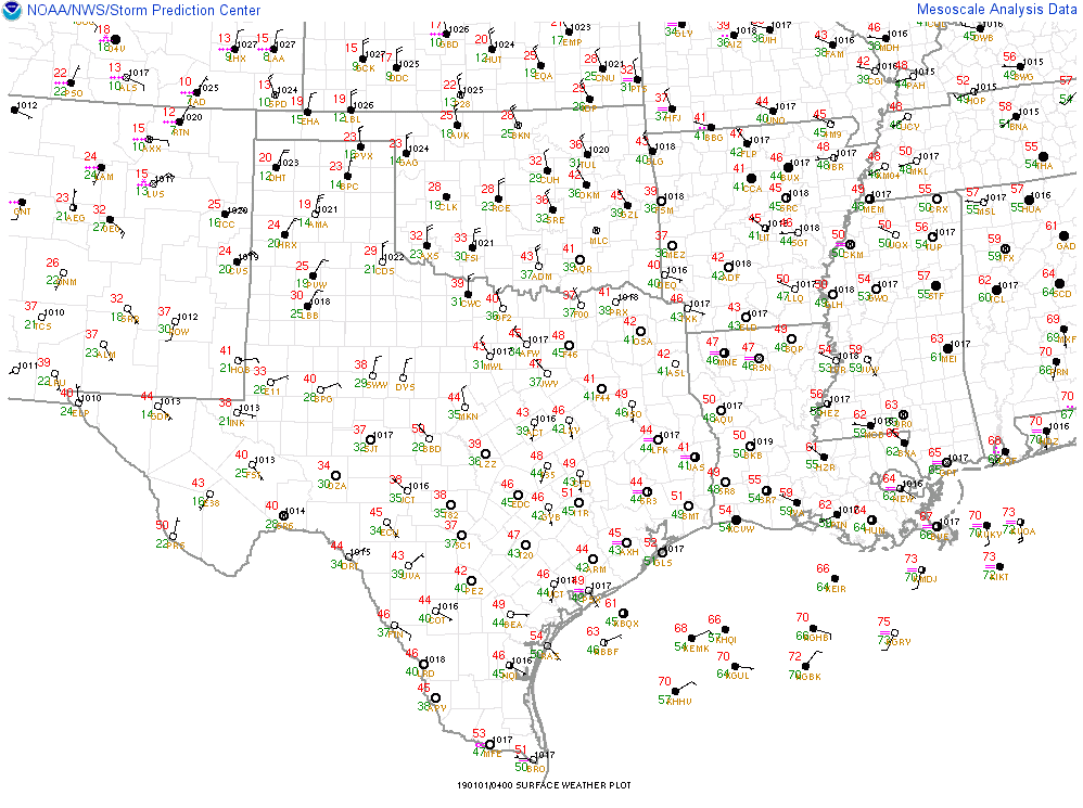
Image
0 likes   
The above post and any post by Ntxw is NOT an official forecast and should not be used as such. It is just the opinion of the poster and may or may not be backed by sound meteorological data. It is NOT endorsed by any professional institution including Storm2k. For official information, please refer to NWS products.


  Help support Storm2K!

Help Support Storm2K


User avatar
bubba hotep
S2K Supporter
S2K Supporter
Posts: 5837
Joined: Wed Dec 28, 2016 1:00 am
Location: Collin County Texas

Re: Texas Winter 2018-2019

#2036 Postby bubba hotep » Mon Dec 31, 2018 11:18 pm

Ntxw wrote:This is a very sensitive track and temp profile. We're going to fall tomorrow throughout the day from the upper 30s. If we're sitting near 30 by tomorrow night it's going to get nasty ice wise with overrunning.


FWD might have to go straight to Winter Storm Warnings for some counties in N. Texas.
0 likes   
Winter time post are almost exclusively focused on the DFW area.

User avatar
Ntxw
Storm2k Moderator
Storm2k Moderator
Posts: 22793
Joined: Wed Oct 21, 2009 6:34 pm
Location: DFW, Texas

Re: Texas Winter 2018-2019

#2037 Postby Ntxw » Mon Dec 31, 2018 11:23 pm

bubba hotep wrote:
Ntxw wrote:This is a very sensitive track and temp profile. We're going to fall tomorrow throughout the day from the upper 30s. If we're sitting near 30 by tomorrow night it's going to get nasty ice wise with overrunning.


FWD might have to go straight to Winter Storm Warnings for some counties in N. Texas.


We've seen some wild swings track wise just the past 48 hours. From one swing to another, I'm not sure why so many here got so worked over such drastic changes in such a short period of time. But it shows the dilemma the NWS is in likely the same headache.
3 likes   
The above post and any post by Ntxw is NOT an official forecast and should not be used as such. It is just the opinion of the poster and may or may not be backed by sound meteorological data. It is NOT endorsed by any professional institution including Storm2k. For official information, please refer to NWS products.


  Help support Storm2K!

Help Support Storm2K


User avatar
EnnisTx
S2K Supporter
S2K Supporter
Posts: 896
Joined: Sat Dec 26, 2015 4:06 pm
Location: Albany, Texas
Contact:

Re: Texas Winter 2018-2019

#2038 Postby EnnisTx » Mon Dec 31, 2018 11:28 pm

Ntxw wrote:
bubba hotep wrote:
Ntxw wrote:This is a very sensitive track and temp profile. We're going to fall tomorrow throughout the day from the upper 30s. If we're sitting near 30 by tomorrow night it's going to get nasty ice wise with overrunning.


FWD might have to go straight to Winter Storm Warnings for some counties in N. Texas.


We've seen some wild swings track wise just the past 48 hours. From one swing to another, I'm not sure why so many here got so worked over such drastic changes in such a short period of time. But it shows the dilemma the NWS is in likely the same headache.


I think it's just the kid in us all. Although I don't think ice storms are good for anyone. Bring the snow!!
2 likes   

User avatar
Ntxw
Storm2k Moderator
Storm2k Moderator
Posts: 22793
Joined: Wed Oct 21, 2009 6:34 pm
Location: DFW, Texas

Re: Texas Winter 2018-2019

#2039 Postby Ntxw » Mon Dec 31, 2018 11:30 pm

It does appear that the southern movement on the models is indeed due to the northern stream getting out of the way. So two factors likely in play here which I think Bubba gave us insight on.

ULL largely will have a mind of its own to go where it pleases. Secondly the initial band of precip will interact with incoming cold, the overrunning wasn't difficult to see several days ago given pattern recognition but unsure of the surface surge of cold, which does appear to have a good push thus far.

Snow will be dependent on the track of that ULL as cold air will erode due to WAA ahead of the system (lots of qpf). Need the ULL to help cool the column with enough moisture to stick around on its northern and northeastern fringes Weds night/Thurs.
6 likes   
The above post and any post by Ntxw is NOT an official forecast and should not be used as such. It is just the opinion of the poster and may or may not be backed by sound meteorological data. It is NOT endorsed by any professional institution including Storm2k. For official information, please refer to NWS products.


  Help support Storm2K!

Help Support Storm2K


User avatar
EnnisTx
S2K Supporter
S2K Supporter
Posts: 896
Joined: Sat Dec 26, 2015 4:06 pm
Location: Albany, Texas
Contact:

Re: Texas Winter 2018-2019

#2040 Postby EnnisTx » Tue Jan 01, 2019 12:41 am

National Weather Service still not that impressed with any of the changes.

FXUS64 KFWD 010313
AFDFWD

Area Forecast Discussion
National Weather Service Fort Worth TX
913 PM CST Mon Dec 31 2018


.UPDATE...

No major changes planned to the overnight forecast. However, will
be lowering the New Year`s Day temperatures slightly, based on
latest guidance and the strength of the post-frontal cold
advection now occurring in OK. With low clouds and a biting north
wind, much of the northwest half of the forecast area will remain
entrenched in the 30s all day tomorrow.

No changes planned to the current Winter Storm Watch
configuration. New NAM guidance doesn`t immediately suggest a need
to expand the watch, but does support the pre-advertised threat of
appreciable freezing rain in our west central counties Wednesday.

The greater DFW Metroplex still appears to lie on the interface
between quasi-freezing temperatures and appreciable rainfall
Wednesday. Ice on elevated surfaces, and perhaps some bridge
decks, remains a distinct possibility Wednesday morning,
particularly in Denton, Tarrant and Johnson Counties.

Considerable uncertainty remains, however, as to how the near-
surface temperature profiles Wednesday will be modulated by: 1)
cold air advection, 2) diabatic processes associated with the
evolving precipitation, and 3) surface soil temperatures. We
should have more clarity on these factors, as well as the
evolution of the precipitation shield itself, by tomorrow.

Bradshaw
0 likes   


Return to “Winter Weather”

Who is online

Users browsing this forum: No registered users and 45 guests