Tropical Cyclone-Related Anniversaries [Five-year Intervals Only]
Moderator: S2k Moderators
Forum rules
The posts in this forum are NOT official forecasts and should not be used as such. They are just the opinion of the poster and may or may not be backed by sound meteorological data. They are NOT endorsed by any professional institution or STORM2K. For official information, please refer to products from the National Hurricane Center and National Weather Service.
-
- Category 4
- Posts: 913
- Joined: Thu Aug 02, 2018 5:29 pm
- Location: Madison, WI
Re: Tropical Cyclone-Related Anniversaries [Five-year Intervals Only]
Goodness, look at that "fist" shape as it moved in. Classic signature of a storm about to bomb out. As I mentioned in the Florence thread, it wouldn't have needed much more time over water to reach Cat 3 and break the CONUS MH landfall "drought" that began after Wilma and continued until Harvey.
The U.S. caught quite a break given that it basically took the storm the entire trek across the Gulf to rebuild its core to that point after taking the long way across Cuba, if you can call entire neighborhoods being washed away "catching a break." Relative to the surge and wind that would have gone into Galveston and Houston had it come back up to a 4, I guess it is...kinda.
Quite a storm and crazy that it ended up in the western Gulf from where it was out in the Atlantic, climatologically abnormal ridges can do funny things, as the Carolinas are being reminded ten years to the day.
2 likes
-
- Tropical Low
- Posts: 25
- Age: 60
- Joined: Tue Aug 22, 2017 10:52 pm
- Location: Galveston, TX
Re: Tropical Cyclone-Related Anniversaries [Five-year Intervals Only]
Ten years ago we were supposed to be in Galveston, Texas. We wanted to come back to Texas after spending several years in Connecticut for work. Then 3 weeks before our move, our youngest daughter became extremely ill. Our moving date to Galveston was August 31st but she had an emergency surgery which probably saved our livelihood and more.
We moved to Galveston the following year. The devastation was still all around us, piles of cars on Bolivar, homes stood in disrepair all over the island. Ike came and left his mark.
Ten years later, we are still here - very fortunate to have Harvey basically miss us - ever wary looking at tropicaltidbits for the next storm through the whole season. The people and the beach are both awesome here so its worth the stay. And city strives to update its infrastructure even as voters prevent many measures. I have long been a lurker of meteorology bbs's and now this forum. I appreciate you all very much.
2 likes
-
- Category 2
- Posts: 714
- Age: 30
- Joined: Sun Dec 05, 2010 3:05 pm
Re: Tropical Cyclone-Related Anniversaries [Five-year Intervals Only]
15 years since Hurricane Isabel hit North Carolina.
1 likes
Kay '22 Hilary '23
- mrbagyo
- Category 5
- Posts: 3617
- Age: 32
- Joined: Thu Apr 12, 2012 9:18 am
- Location: 14.13N 120.98E
- Contact:
Re: Tropical Cyclone-Related Anniversaries [Five-year Intervals Only]
This day, 80 years ago... The Great Hurricane of '38 roared towards the New England /Long Island region.
1 likes
The posts in this forum are NOT official forecast and should not be used as such. They are just the opinion of the poster and may or may not be backed by sound meteorological data. They are NOT endorsed by any professional institution or storm2k.org. For official information, please refer to RSMC, NHC and NWS products.
-
- Category 5
- Posts: 2434
- Age: 31
- Joined: Thu Sep 07, 2017 3:39 pm
- Location: St. Petersburg, FL → Scandinavia
Re: Tropical Cyclone-Related Anniversaries [Five-year Intervals Only]
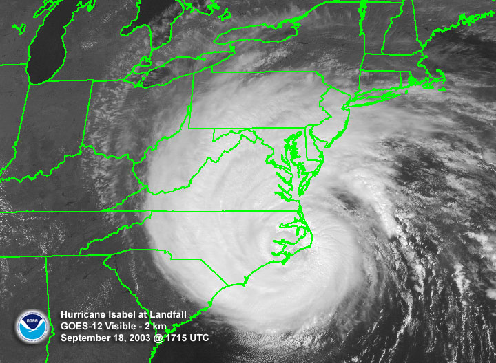
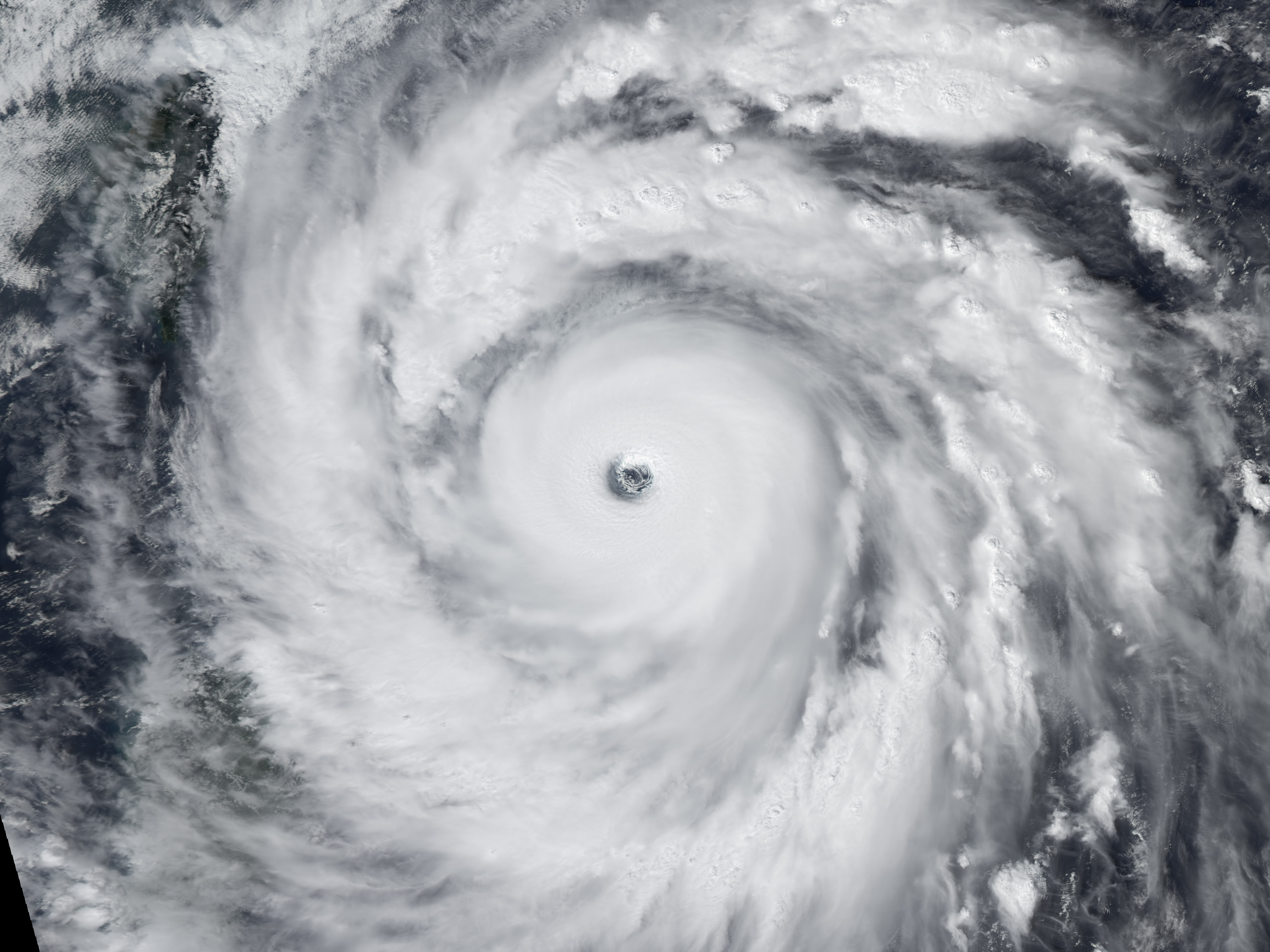
On September 16, 1988, Hurricane Gilbert made landfall at the Mexican city of La Pesca, Tamaulipas, with winds of 125 mph (200 km/hr). It had already brought destruction upon the Yucatán peninsula and the Caribbean islands. Along the way it set a new low-pressure record that would stand for 17 years. ... The hurricane brought a 19-ft (6-m) storm surge to the eastern shore of Jamaica and brought tropical downpours and high winds to the entire island. It left 49 dead, destroyed 100,000 homes, and caused US$700 million in damages (70% of that agricultural losses). ... When Gilbert hit the Yucatán Peninsula, it pushed storm surge 5 km (3 mi) inland, brought over 10″ (250 mm) of rain to the peninsula, and did billions of dollars (1988 US$) in damage. It left the area’s tourism infrastructure in tatters for the rest of year. It also brought torrential rains to northern Central America, leaving scores of people dead, thousands homeless, and crops in ruins. The trip over the Yucatán did reduce Gilbert down to Category-3 level, but the warm waters of the Gulf of Mexico allowed it to regain some of its strength before hitting the Mexican state of Tamaulipas. Northern Mexico suffered heavy rains, mudslides, and flash floods. Mexico’s third largest city, Monterrey, was left without power or water for days.
https://noaahrd.wordpress.com/2018/09/19/30th-anniversary-of-hurricane-gilbert/
On September 16, 1928, the deadliest hurricane in Florida’s history struck West Palm Beach. As it moved inland it drove the waters of Lake Okeechobee against the mud levees on its shores. When the levees failed, a surge inundated the communities of Okeechobee City, South Bay and Belle Glade, causing thousands of deaths. ... Richard Gray, Meteorologist in Charge in Miami, thought that the storm would recurve and not strike south Florida, but warnings were issued from Miami to Titusville. Disruption of communications made tracking the center of the storm difficult, so it came as a surprise on the evening of Sept. 16th when the eye passed over West Palm Beach. As the hurricane traveled over the lake to the west of the city, its winds shifted from northerly to southerly. This sloshed the waters of the shallow lake first against the southern dikes, then across to the northern ones. The meager dried-mud dikes failed on both sides, causing a flash floods that caught people huddled in their homes unable to escape. ... The death toll in the Lake region were in the thousands. Public health concerns and persistent flood waters out-weighed the need for accounting for all the dead, and the bodies were disposed of in either mass graves or burnt on huge pyres. The Red Cross estimate of 1,836 dead stood for a long while, but recent re-evaluations put the total in excess of 2,500. The majority of the deaths were migrant farm workers, mainly of African-American descent. White victims were buried with ceremony, whereas African-American ones were burned in funeral pyres with the ashes buried in mass graves with no markers. Many reports state that surviving African-Americans were forced to recover dead bodies and to do other recovery work without pay.
https://noaahrd.wordpress.com/2018/09/18/90th-anniversary-of-lake-okeechobee-hurricane/
1 likes
CVW / MiamiensisWx / Shell Mound
The posts in this forum are NOT official forecasts and should not be used as such. They are just the opinion of the poster and may or may not be backed by sound meteorological data. They are NOT endorsed by any professional institution or STORM2K. For official information, please refer to products from the NHC and NWS.
- doomhaMwx
- Category 5
- Posts: 2400
- Age: 25
- Joined: Tue Apr 18, 2017 4:01 am
- Location: Baguio/Benguet, Philippines
- Contact:
Re: Tropical Cyclone-Related Anniversaries [Five-year Intervals Only]
Sept 27, 2008 -- From a decade ago, 2008's SuperTyphoon Jangmi at category 5 intensity over the Philippine Sea. One striking thing about this system is the very impressive structure it exhibited. Excellent convective banding in all quadrants.
3 likes
Like my content? Consider giving a tip.
Re: Tropical Cyclone-Related Anniversaries [Five-year Intervals Only]
One of a few typhoons to have recon since the end of the recon era in 1987. She wasn't the most impressive though. Imagine...
0 likes
Remember, all of my post aren't official. For official warnings and discussions, Please refer to your local NWS products...
NWS for the Western Pacific
https://www.weather.gov/gum/
NWS for the Western Pacific
https://www.weather.gov/gum/
- doomhaMwx
- Category 5
- Posts: 2400
- Age: 25
- Joined: Tue Apr 18, 2017 4:01 am
- Location: Baguio/Benguet, Philippines
- Contact:
Re: Tropical Cyclone-Related Anniversaries [Five-year Intervals Only]
Oct 3, 1963 -- Atlantic Hurricane Flora from 55 years ago.
https://noaahrd.wordpress.com/2018/10/0 ... ane-flora/
On the night of October 3, 1963, Hurricane Flora smashed into the southern coast of Haiti. It raked the country with
145 mph (230 km/hr) winds and dumped tremendous downpours on its mountains. It would become one of the deadliest and
wettest Atlantic hurricanes on record.
1 likes
Like my content? Consider giving a tip.
- mrbagyo
- Category 5
- Posts: 3617
- Age: 32
- Joined: Thu Apr 12, 2012 9:18 am
- Location: 14.13N 120.98E
- Contact:
Re: Tropical Cyclone-Related Anniversaries [Five-year Intervals Only]
20 years ago - on this day, on this very hour
Super Typhoon Zeb made landfall over the remote coastal region of Isabela Province in Northern Philippines.
4 likes
The posts in this forum are NOT official forecast and should not be used as such. They are just the opinion of the poster and may or may not be backed by sound meteorological data. They are NOT endorsed by any professional institution or storm2k.org. For official information, please refer to RSMC, NHC and NWS products.
- doomhaMwx
- Category 5
- Posts: 2400
- Age: 25
- Joined: Tue Apr 18, 2017 4:01 am
- Location: Baguio/Benguet, Philippines
- Contact:
Re: Tropical Cyclone-Related Anniversaries [Five-year Intervals Only]
mrbagyo wrote:20 years ago - on this day, on this very hour
Super Typhoon Zeb made landfall over the remote coastal region of Isabela Province in Northern Philippines.
http://tropic.ssec.wisc.edu/storm_archive/1998/storms/zeb/ZEB4C.GIF
http://tropic.ssec.wisc.edu/storm_archive/1998/storms/zeb/ZEB4B.GIF
http://tropic.ssec.wisc.edu/storm_archive/1998/storms/zeb/ZEB4A.GIF
One of my personal favorites. (As you can see, Zeb is also my avatar)
Here is another impressive satellite image of this howler.
2 likes
Like my content? Consider giving a tip.
- doomhaMwx
- Category 5
- Posts: 2400
- Age: 25
- Joined: Tue Apr 18, 2017 4:01 am
- Location: Baguio/Benguet, Philippines
- Contact:
Re: Tropical Cyclone-Related Anniversaries [Five-year Intervals Only]
Five years since SuperTyphoon Haiyan slammed the central Philippines. We all know of the horrific aftermath.
4 likes
Like my content? Consider giving a tip.
- galaxy401
- Category 5
- Posts: 2301
- Age: 29
- Joined: Sat Aug 25, 2012 9:04 pm
- Location: Casa Grande, Arizona
Re: Tropical Cyclone-Related Anniversaries [Five-year Intervals Only]
Haiyan was truly a league on its own. If there ever exists a "Category 6" you will probably find a picture of Haiyan. It was both amazing and terrifying track this storm back when it was active.
3 likes
Got my eyes on moving right into Hurricane Alley: Florida.
Re: Tropical Cyclone-Related Anniversaries [Five-year Intervals Only]
Imran_doomhaMwx wrote:Five years since SuperTyphoon Haiyan slammed the central Philippines. We all know of the horrific aftermath.
https://i.imgur.com/3G24znO.png
http://cimss.ssec.wisc.edu/goes/blog/wp-content/uploads/2013/11/131107_coms1_vis_haiyan_landfall_anim.gif
Truly an incredible storm. I think about it everytime I watch golf because one of my favorite players, Jason Day, lost a lot of family in the storm. Very sad.
0 likes
- 1900hurricane
- Category 5
- Posts: 6044
- Age: 33
- Joined: Fri Feb 06, 2015 12:04 pm
- Location: Houston, TX
- Contact:
Re: Tropical Cyclone-Related Anniversaries [Five-year Intervals Only]
I'm a few days late, but 15 years ago in 2004, Super Typhoon Dianmu achieved peak intensity in the Philippine Sea. The system is by far the most intense WPac typhoon during the typically down month of June since at least 1970. JTWC gave the system a peak intensity of 155 kt, but satellite presentation alludes to a legitimate Tip challenger.
3 likes
Contract Meteorologist. TAMU & MSST. Fiercely authentic, one of a kind. We are all given free will, so choose a life meant to be lived. We are the Masters of our own Stories.
Opinions expressed are mine alone.
Follow me on Twitter at @1900hurricane : Read blogs at https://1900hurricane.wordpress.com/
Opinions expressed are mine alone.
Follow me on Twitter at @1900hurricane : Read blogs at https://1900hurricane.wordpress.com/
Re: Tropical Cyclone-Related Anniversaries [Five-year Intervals Only]
Strongest June typhoon ever recorded may be super typhoon Kit in 1966, 880 mbar pressure estimated by JMA and 170 kt wind estimated by JTWC on June 26, though these winds are likely an overestimate.
June super typhoons since 1970: Koryn 93 (130 kt), Nestor 97 (140 kt), Dianmu 04 (155 kt), Guchol 12 (130 kt).
1 likes
- 1900hurricane
- Category 5
- Posts: 6044
- Age: 33
- Joined: Fri Feb 06, 2015 12:04 pm
- Location: Houston, TX
- Contact:
Re: Tropical Cyclone-Related Anniversaries [Five-year Intervals Only]
styzeb wrote:Strongest June typhoon ever recorded may be super typhoon Kit in 1966, 880 mbar pressure estimated by JMA and 170 kt wind estimated by JTWC on June 26, though these winds are likely an overestimate.
June super typhoons since 1970: Koryn 93 (130 kt), Nestor 97 (140 kt), Dianmu 04 (155 kt), Guchol 12 (130 kt).
Good call on Kit, I forget about it sometimes since it occurred before 1970, and I haven't done much work on storms before then. JMA's 880 mb might be a mite too deep, but the 2095 m 700 mb height measured at 0227Z on June 26th does support about 886 mb or so. With that kind of pressure, the chances of JTWC's intensity being an overestimate might not be as high as you think.
2 likes
Contract Meteorologist. TAMU & MSST. Fiercely authentic, one of a kind. We are all given free will, so choose a life meant to be lived. We are the Masters of our own Stories.
Opinions expressed are mine alone.
Follow me on Twitter at @1900hurricane : Read blogs at https://1900hurricane.wordpress.com/
Opinions expressed are mine alone.
Follow me on Twitter at @1900hurricane : Read blogs at https://1900hurricane.wordpress.com/
Re: Tropical Cyclone-Related Anniversaries [Five-year Intervals Only]
1900hurricane wrote:styzeb wrote:Strongest June typhoon ever recorded may be super typhoon Kit in 1966, 880 mbar pressure estimated by JMA and 170 kt wind estimated by JTWC on June 26, though these winds are likely an overestimate.
June super typhoons since 1970: Koryn 93 (130 kt), Nestor 97 (140 kt), Dianmu 04 (155 kt), Guchol 12 (130 kt).
Good call on Kit, I forget about it sometimes since it occurred before 1970, and I haven't done much work on storms before then. JMA's 880 mb might be a mite too deep, but the 2095 m 700 mb height measured at 0227Z on June 26th does support about 886 mb or so. With that kind of pressure, the chances of JTWC's intensity being an overestimate might not be as high as you think.
That's not I think, I copy it from wikipedia . Because my english is not good, I can't speak much.
0 likes
Re: Tropical Cyclone-Related Anniversaries [Five-year Intervals Only]
Any pictures of Kit at peak? Can't find any.
0 likes
Remember, all of my post aren't official. For official warnings and discussions, Please refer to your local NWS products...
NWS for the Western Pacific
https://www.weather.gov/gum/
NWS for the Western Pacific
https://www.weather.gov/gum/
Re: Tropical Cyclone-Related Anniversaries [Five-year Intervals Only]
If this isn't the correct forum I'll ask a admin or moderator to move. I'll never forget this date August 17th 1969. I was a mere lad of 7 when this monster rolled ashore
in Pass Christian Ms. during the night. it began my lifelong fascination with tropical cyclones. I was living in Gulfport at the time and received the full impact of the
NE quadrant. I'm 57 years old now and can still hear that sound today. The only words I can think of to describe it is a runaway freight train right next to window. We
were very lucky, the following morning we left the shelter and our home was still standing. We only had minor roof damage and one broken window pane.
0 likes
-
- Category 4
- Posts: 907
- Joined: Sun Apr 18, 2010 3:21 am
- Location: Ozark, AL
Re: Tropical Cyclone-Related Anniversaries [Five-year Intervals Only]
Seems it was supposed to turn NE towards NW Florida but never made the turn. Advisory from New Orleans indicated 190 MPH winds. Also no Tropical Storm warning surrounding the Hurricane Warning. They did Gale Warnings instead.
3 likes
Who is online
Users browsing this forum: Cpv17, Google [Bot], Hurricane2022, HurricaneBrain, MetroMike, riapal, WAcyclone, WiscoWx02 and 37 guests