ATL: DORIAN - Post-Tropical - Discussion
Moderator: S2k Moderators
-
1900hurricane

- Category 5

- Posts: 6063
- Age: 34
- Joined: Fri Feb 06, 2015 12:04 pm
- Location: Houston, TX
- Contact:
Re: ATL: DORIAN - Hurricane - Discussion
SEQ had the strongest winds on the first pass too.
2 likes
Contract Meteorologist. TAMU & MSST. Fiercely authentic, one of a kind. We are all given free will, so choose a life meant to be lived. We are the Masters of our own Stories.
Opinions expressed are mine alone.
Follow me on Twitter at @1900hurricane : Read blogs at https://1900hurricane.wordpress.com/
Opinions expressed are mine alone.
Follow me on Twitter at @1900hurricane : Read blogs at https://1900hurricane.wordpress.com/
-
emeraldislenc
- Category 2

- Posts: 601
- Joined: Fri Aug 24, 2012 4:49 pm
- Location: Emerald Isle NC
-
emeraldislenc
- Category 2
- Posts: 601
- Joined: Fri Aug 24, 2012 4:49 pm
- Location: Emerald Isle NC
-
supercane4867
- Category 5
- Posts: 4966
- Joined: Wed Nov 14, 2012 10:43 am


Re: ATL: DORIAN - Hurricane - Discussion
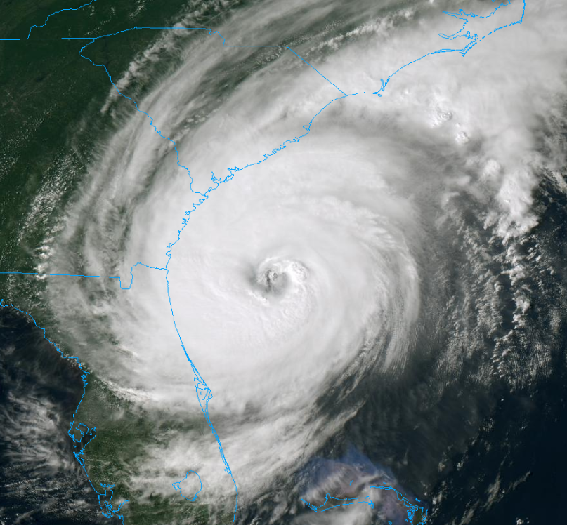
Central pressure down to 962 and center has wobbled around toward the north (possibly a little earlier than forecast). 5PM update will be an important one. If Dorian moves with the shear and stays off shore so that the dry air intrusion doesn't get into the core circulation he could easily return to category 3. Some areas of Georgia are prone to storm surge flooding because of the shape of the shoreline, the local flood management agencies have undoubtedly evacuated those areas already.
2 likes
-
Hypercane_Kyle

- Category 5
- Posts: 3465
- Joined: Sat Mar 07, 2015 7:58 pm
- Location: Cape Canaveral, FL
Re: ATL: DORIAN - Hurricane - Discussion
Definitely looking better this afternoon.

5 likes
My posts are my own personal opinion, defer to the National Hurricane Center (NHC) and other NOAA products for decision making during hurricane season.
-
supercane4867
- Category 5
- Posts: 4966
- Joined: Wed Nov 14, 2012 10:43 am
Re: ATL: DORIAN - Hurricane - Discussion
I can't remember a hurricane near this location that looked better than Dorian since maybe Hugo
2 likes
-
1900hurricane
- Category 5
- Posts: 6063
- Age: 34
- Joined: Fri Feb 06, 2015 12:04 pm
- Location: Houston, TX
- Contact:
Re: ATL: DORIAN - Hurricane - Discussion
The way the core is filling back in on radar reminds me of Ike '08 just prior to final landfall.
2 likes
Contract Meteorologist. TAMU & MSST. Fiercely authentic, one of a kind. We are all given free will, so choose a life meant to be lived. We are the Masters of our own Stories.
Opinions expressed are mine alone.
Follow me on Twitter at @1900hurricane : Read blogs at https://1900hurricane.wordpress.com/
Opinions expressed are mine alone.
Follow me on Twitter at @1900hurricane : Read blogs at https://1900hurricane.wordpress.com/
-
PandaCitrus
- Category 1

- Posts: 424
- Joined: Mon Sep 04, 2017 2:44 pm
Re: ATL: DORIAN - Hurricane - Discussion
supercane4867 wrote:I can't remember a hurricane near this location that looked better than Dorian since maybe Hugo
https://uploads.disquscdn.com/images/d25cb38b657ecdf17c92f41b3d47102ba3660423eb83f6761b9f7c5212c5f9ff.png
The Euro model gets the storm down to 942MB before the NC coast. That could be Hugo strength. A Cat 4 is possible here if it deepens that much.
1 likes
-
TheDreamTraveler

- Category 2
- Posts: 645
- Joined: Sun Aug 22, 2010 3:10 am
- Location: PA
Re: ATL: DORIAN - Hurricane - Discussion
1900hurricane wrote:The way the core is filling back in on radar reminds me of Ike '08 just prior to final landfall.
Same here. Ike was such an underestimated storm. I feel like Dorian might end up being looked at the same if it gets close enough or makes landfall. Even if it doesn't it'll still cause a decent amount of damage.
2 likes
-
supercane4867
- Category 5
- Posts: 4966
- Joined: Wed Nov 14, 2012 10:43 am
Re: ATL: DORIAN - Hurricane - Discussion
PandaCitrus wrote:supercane4867 wrote:I can't remember a hurricane near this location that looked better than Dorian since maybe Hugo
https://uploads.disquscdn.com/images/d25cb38b657ecdf17c92f41b3d47102ba3660423eb83f6761b9f7c5212c5f9ff.png
The Euro model gets the storm down to 942MB before the NC coast. That could be Hugo strength. A Cat 4 is possible here if it deepens that much.
CAT4 is not likely due to its structure, but a 110kt CAT3 is very plausible with 942mb.
4 likes

Re: ATL: DORIAN - Hurricane - Discussion
several 105-110 kt FL wind obs there.
1 likes
Very useful information on the Dvorak Technique --
https://severe.worldweather.wmo.int/TCF ... kBeven.pdf
https://severe.worldweather.wmo.int/TCF ... kBeven.pdf
-
MGC

- S2K Supporter

- Posts: 5940
- Joined: Sun Mar 23, 2003 9:05 pm
- Location: Pass Christian MS, or what is left.
Re: ATL: DORIAN - Hurricane - Discussion
Eye would have to contract a lot to reach Cat-4. Cat-3 is possible. Dorian is looking better and better.....MGC
2 likes
-
supercane4867
- Category 5
- Posts: 4966
- Joined: Wed Nov 14, 2012 10:43 am
-
HurricaneEnzo

- Category 2
- Posts: 744
- Joined: Wed Mar 14, 2018 12:18 pm
- Location: Newport, NC (Hurricane Alley)
Re: RE: Re: ATL: DORIAN - Hurricane - Discussion
Arthur in 2014 had a pretty nice appearance. Looked stronger that it actually was IMOsupercane4867 wrote:I can't remember a hurricane near this location that looked better than Dorian since maybe Hugo
Sent from my SM-N975U using Tapatalk
2 likes
Bertha 96' - Fran 96' - Bonnie 98' - Dennis 99' - Floyd 99' - Isabel 03' - Alex 04' - Ophelia 05' - Irene 11' - Arthur 14' - Matthew 16' - Florence 18' - Dorian 19' - Isaias 20' (countless other tropical storms and Hurricane swipes)
I am not a Professional Met just an enthusiast. Get your weather forecasts from the Pros!
I am not a Professional Met just an enthusiast. Get your weather forecasts from the Pros!
Re: ATL: DORIAN - Hurricane - Discussion
Copying over a post I made from another forum that, while not about Dorian's current track, is about its future interactions and their impact on synoptics:
I've been watching Lingling and Dorian recently, and I'm interested that they both undergo extratropical transition and integrate their momentum into the jet stream around the same time:

Dorian and Lingling are the symmetrically opposite 968mb lows here. Their angular momentum seems to enhance a dipole pattern, and the timing of their momentum transfer will be critical to how it sets up here. Regardless of the exact configuration, it looks like this will split the initiating tropospheric polar vortex into two lobes and allow a major heat/moisture intrusion from the Pacific

As we enter peak hurricane season, it's important to remember that one of the major heat engines that moves heat from equator to pole are tropical cyclones, so watching their activity will be critical to see how the freezing season initiates (or fails to)
This to me indicates that the melting season is not over yet and way may see losses for the next two weeks. I would be stunned if the AO does not go negative again in the next two weeks, but then again I'm just a naive observer and not a pro meteorologist.
I've been watching Lingling and Dorian recently, and I'm interested that they both undergo extratropical transition and integrate their momentum into the jet stream around the same time:
Dorian and Lingling are the symmetrically opposite 968mb lows here. Their angular momentum seems to enhance a dipole pattern, and the timing of their momentum transfer will be critical to how it sets up here. Regardless of the exact configuration, it looks like this will split the initiating tropospheric polar vortex into two lobes and allow a major heat/moisture intrusion from the Pacific
As we enter peak hurricane season, it's important to remember that one of the major heat engines that moves heat from equator to pole are tropical cyclones, so watching their activity will be critical to see how the freezing season initiates (or fails to)
This to me indicates that the melting season is not over yet and way may see losses for the next two weeks. I would be stunned if the AO does not go negative again in the next two weeks, but then again I'm just a naive observer and not a pro meteorologist.
5 likes
-
PandaCitrus
- Category 1
- Posts: 424
- Joined: Mon Sep 04, 2017 2:44 pm
Re: ATL: DORIAN - Hurricane - Discussion
The eye is tightening up on radar the past hour. Weaker East side starting to fill in.
1 likes
Re: ATL: DORIAN - Hurricane - Discussion
extrap sub 960
3 likes
Very useful information on the Dvorak Technique --
https://severe.worldweather.wmo.int/TCF ... kBeven.pdf
https://severe.worldweather.wmo.int/TCF ... kBeven.pdf
-
toad strangler

- S2K Supporter
- Posts: 4546
- Joined: Sun Jul 28, 2013 3:09 pm
- Location: Earth
- Contact:
Re: ATL: DORIAN - Hurricane - Discussion
Def looking better organized.
1 likes
My Weather Station
https://www.wunderground.com/dashboard/pws/KFLPORTS603
https://www.wunderground.com/dashboard/pws/KFLPORTS603
Who is online
Users browsing this forum: No registered users and 25 guests