Noticed the wave at 51w firing some convection.
The CMC maintains some vorticity as do some other models
Wonder if this has any chance of development.
Trough of Low Pressure north of the Greater Antilles (Is INVEST 95L)
Moderator: S2k Moderators
Forum rules

The posts in this forum are NOT official forecasts and should not be used as such. They are just the opinion of the poster and may or may not be backed by sound meteorological data. They are NOT endorsed by any professional institution or STORM2K. For official information, please refer to products from the National Hurricane Center and National Weather Service.
-
AtlanticWind

- S2K Supporter

- Posts: 1898
- Age: 67
- Joined: Sun Aug 08, 2004 9:57 pm
- Location: Plantation,Fla
Trough of Low Pressure north of the Greater Antilles (Is INVEST 95L)
Last edited by AtlanticWind on Mon Sep 09, 2019 10:40 am, edited 2 times in total.
2 likes
-
AtlanticWind
- S2K Supporter
- Posts: 1898
- Age: 67
- Joined: Sun Aug 08, 2004 9:57 pm
- Location: Plantation,Fla
Re:Central ATLC Tropical Wave Near 51W
Convection continues to fire ,might be interaction with upper low
0 likes


-
AtlanticWind
- S2K Supporter
- Posts: 1898
- Age: 67
- Joined: Sun Aug 08, 2004 9:57 pm
- Location: Plantation,Fla
Re: Central ATLC Tropical Wave Near 51W
Convection really firing now ,not surprised the NHC tagged it.
Have to watch these sneaky ones at the peak of season.
Have to watch these sneaky ones at the peak of season.
0 likes
-
northjaxpro

- S2K Supporter
- Posts: 8900
- Joined: Mon Sep 27, 2010 11:21 am
- Location: Jacksonville, FL
Re: Central ATLC Tropical Wave Near 51W
AtlanticWind wrote:Convection really firing now ,not surprised the NHC tagged it.
Have to watch these sneaky ones at the peak of season.
I am watching it closely. The positive NAO forecast to come has me concerned about the pattern evolving, and it is these type of systems like this potential one that can traverse under a building A/B ridge in the coming days and pose another threat God Forbid! However, we are hitting the peak time of tropical cyclone activity in the North Atlantic basin NOW, and Mother Nature is wasting no time catching up on that LONG summer slumber we had saw out there.
Summer Slumber? Wow, isn't that forgotten about now after what has and is still happening with Dorian!!
3 likes
NEVER, EVER SAY NEVER in the tropics and weather in general, and most importantly, with life itself!!
________________________________________________________________________________________
Fay 2008 Beryl 2012 Debby 2012 Colin 2016 Hermine 2016 Julia 2016 Matthew 2016 Irma 2017 Dorian 2019
________________________________________________________________________________________
Fay 2008 Beryl 2012 Debby 2012 Colin 2016 Hermine 2016 Julia 2016 Matthew 2016 Irma 2017 Dorian 2019
-
AtlanticWind
- S2K Supporter
- Posts: 1898
- Age: 67
- Joined: Sun Aug 08, 2004 9:57 pm
- Location: Plantation,Fla

Re: Central ATLC Tropical Wave Near 55w
What is the name of the orange disturbance? All these 90L's......is there a trick to know which is which?
Sent from my SM-N960U using Tapatalk
Sent from my SM-N960U using Tapatalk
1 likes
-
Stormi

- Tropical Depression

- Posts: 86
- Age: 38
- Joined: Sun Aug 18, 2019 10:04 pm
- Location: Northeast FL
Re: Central ATLC Tropical Wave Near 55w
watsx2 wrote:What is the name of the orange disturbance? All these 90L's......is there a trick to know which is which?
Sent from my SM-N960U using Tapatalk
The orange-colored disturbance on the map is 94L. The NHC color-codes any disturbances/invests with less than 40% formation potential within 5 days in yellow, between 40% - 60% in orange, and greater than 60% in red.
1 likes
-
northjaxpro
- S2K Supporter
- Posts: 8900
- Joined: Mon Sep 27, 2010 11:21 am
- Location: Jacksonville, FL
Re: Central ATLC Tropical Wave Near 55w
AtlanticWind wrote:Convection waning ,see what happens at DMax
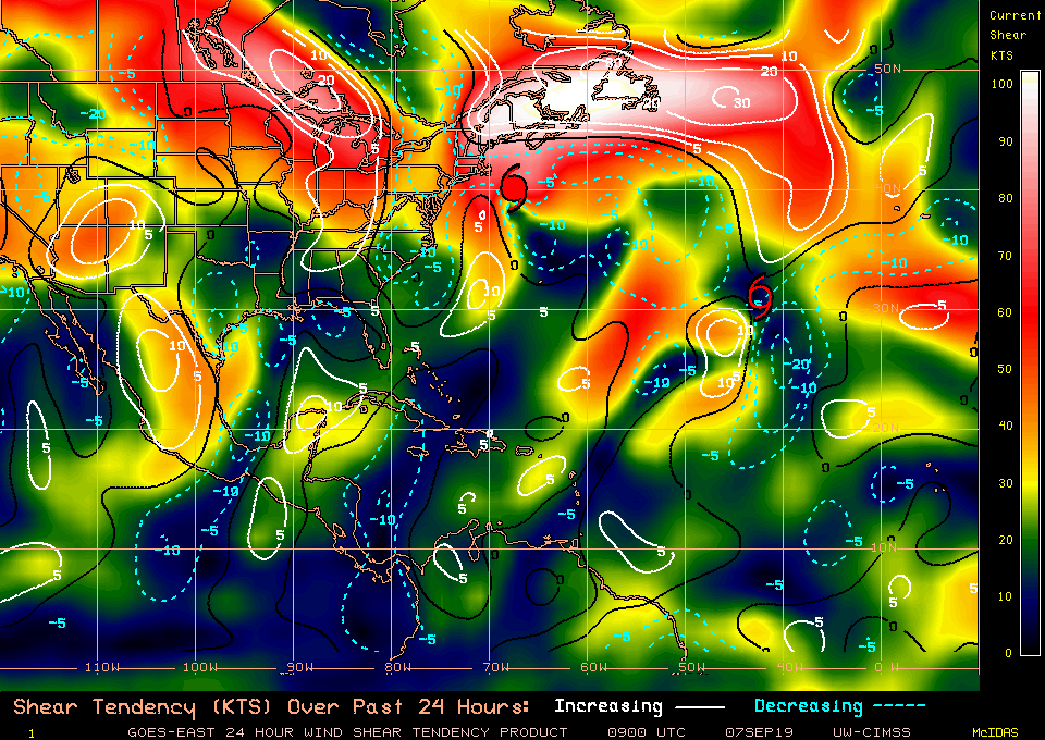
Convection indeed re-firing at DMAX. Just checked the wind shear analysis across the North Atlantic basin and right now only 5-10 knots of shear being shown in the region east of the Lesser Antilles where this Tropical Wave is now. It is in a rather conducive area to spin up at the current time and if convection can continue to maintain or build up.more, we just may have our next invest classified here in this area tomorrow.
0 likes
NEVER, EVER SAY NEVER in the tropics and weather in general, and most importantly, with life itself!!
________________________________________________________________________________________
Fay 2008 Beryl 2012 Debby 2012 Colin 2016 Hermine 2016 Julia 2016 Matthew 2016 Irma 2017 Dorian 2019
________________________________________________________________________________________
Fay 2008 Beryl 2012 Debby 2012 Colin 2016 Hermine 2016 Julia 2016 Matthew 2016 Irma 2017 Dorian 2019
-
northjaxpro
- S2K Supporter
- Posts: 8900
- Joined: Mon Sep 27, 2010 11:21 am
- Location: Jacksonville, FL
Re: Central ATLC Tropical Wave Near 55w
The estimated position of the 1014 mb Low according to NHC is 17 N 56.0 W. per 2: a.m. TWO.
0 likes
NEVER, EVER SAY NEVER in the tropics and weather in general, and most importantly, with life itself!!
________________________________________________________________________________________
Fay 2008 Beryl 2012 Debby 2012 Colin 2016 Hermine 2016 Julia 2016 Matthew 2016 Irma 2017 Dorian 2019
________________________________________________________________________________________
Fay 2008 Beryl 2012 Debby 2012 Colin 2016 Hermine 2016 Julia 2016 Matthew 2016 Irma 2017 Dorian 2019
-
gatorcane

- S2K Supporter
- Posts: 23708
- Age: 48
- Joined: Sun Mar 13, 2005 3:54 pm
- Location: Boca Raton, FL
Re: Central ATLC Tropical Wave Near 55w
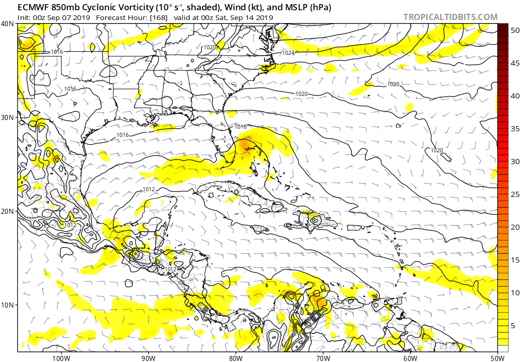
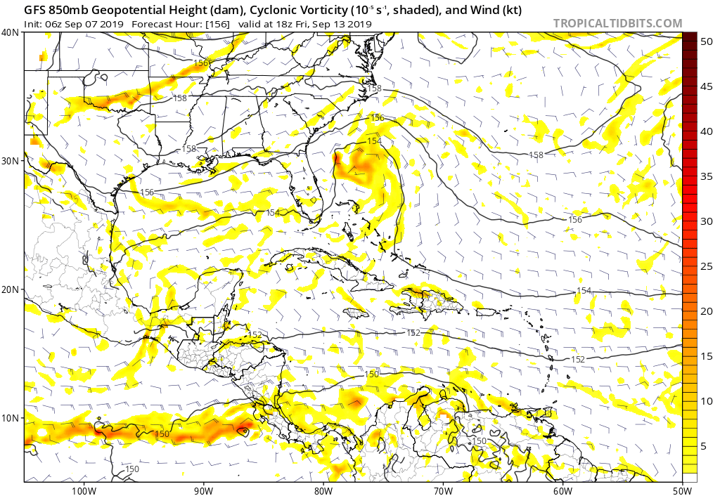
Looks like the Euro develops and GFS hinting at development near Florida. Euro sends this into the GOM
1 likes

Re: Central ATLC Tropical Wave Near 55w
Wave interacting on the SW side of Gabrielle's UL winds.
Setups like this can take many people by suprise.
Need to analyze and watch this one closely.
Could be a fast spin up.
Setups like this can take many people by suprise.
Need to analyze and watch this one closely.
Could be a fast spin up.
1 likes


-
northjaxpro
- S2K Supporter
- Posts: 8900
- Joined: Mon Sep 27, 2010 11:21 am
- Location: Jacksonville, FL
Re: Central ATLC Tropical Wave Near 55w
This indeed could spin up quickly and unfortunately pose problems to the Bahamas, where God forbid they do not need , and possibly to Florida next week Have to watch it closely!!
EURO develops it over the NW Bahamas for Heaven's sake :
Last edited by northjaxpro on Sat Sep 07, 2019 8:27 am, edited 1 time in total.
1 likes
NEVER, EVER SAY NEVER in the tropics and weather in general, and most importantly, with life itself!!
________________________________________________________________________________________
Fay 2008 Beryl 2012 Debby 2012 Colin 2016 Hermine 2016 Julia 2016 Matthew 2016 Irma 2017 Dorian 2019
________________________________________________________________________________________
Fay 2008 Beryl 2012 Debby 2012 Colin 2016 Hermine 2016 Julia 2016 Matthew 2016 Irma 2017 Dorian 2019
-
SFLcane

- S2K Supporter
- Posts: 10281
- Age: 48
- Joined: Sat Jun 05, 2010 1:44 pm
- Location: Lake Worth Florida
Re: Central ATLC Tropical Wave Near 55w
This area was dropped from NHC TWO models aren’t doing much with it.
0 likes
-
gatorcane
- S2K Supporter
- Posts: 23708
- Age: 48
- Joined: Sun Mar 13, 2005 3:54 pm
- Location: Boca Raton, FL
Re: Central ATLC Tropical Wave Near 55w
Upper-level winds looks to be favorable all the way to the Bahamas and Florida. I certainly would keep an eye on this system.
0 likes
Re: Central ATLC Tropical Wave Near 55w
Basically has a whole week to brew in the Bahamas.
Wondering what's slowing this down so much.
Wondering what's slowing this down so much.
1 likes
-
northjaxpro
- S2K Supporter
- Posts: 8900
- Joined: Mon Sep 27, 2010 11:21 am
- Location: Jacksonville, FL
Re: Central ATLC Tropical Wave Near 55w
2 likes
NEVER, EVER SAY NEVER in the tropics and weather in general, and most importantly, with life itself!!
________________________________________________________________________________________
Fay 2008 Beryl 2012 Debby 2012 Colin 2016 Hermine 2016 Julia 2016 Matthew 2016 Irma 2017 Dorian 2019
________________________________________________________________________________________
Fay 2008 Beryl 2012 Debby 2012 Colin 2016 Hermine 2016 Julia 2016 Matthew 2016 Irma 2017 Dorian 2019
-
floridasun78
- Category 5

- Posts: 3755
- Joined: Sun May 17, 2009 10:16 pm
- Location: miami fl
Re: Central ATLC Tropical Wave Near 55w
nhc dont see any thing coming from area look alot shear now over area if look sat pic you clould getting pull too ne and sw
2 likes
Who is online
Users browsing this forum: No registered users and 70 guests