
Dorian
2019SEP01 155019 6.4 935.9 124.6 6.4 6.5 6.5 NO LIMIT OFF OFF OFF OFF 21.47 -68.05 EYE 21 IR 74.4 26.58 76.87 ARCHER GOES16 31.1
ATL: LORENZO - Post-Tropical - Discussion
Moderator: S2k Moderators
Re: ATL: LORENZO - Hurricane - Discussion
1 likes
Very useful information on the Dvorak Technique --
https://severe.worldweather.wmo.int/TCF ... kBeven.pdf
https://severe.worldweather.wmo.int/TCF ... kBeven.pdf
-
1900hurricane

- Category 5

- Posts: 6063
- Age: 34
- Joined: Fri Feb 06, 2015 12:04 pm
- Location: Houston, TX
- Contact:
Re: ATL: LORENZO - Hurricane - Discussion
We got an AMSU estimate at 2138Z from NOAA-15. The estimate is good for 120 kt/939 mb, which seems consistent with the NHC's intensity estimates from 18Z and 00Z. Still think I would have bumped to 130 kt at 03Z.
CIMSS/NESDIS-USAF/NRL AMSU TC Intensity Estimation:
HURRICANE LORENZO
Thursday 26sep19 Time: 2138 UTC
Latitude: 16.37 Longitude: -40.78
Storm position corresponds to AMSU-A FOV 18 [1<--->30]
-----------------------------------------------------------------
| Estimated MSLP: 939 hPa
| Estimated Maximum Sustained Wind: 120 kts
| Estimate Confidence: Good ( +/- 10mb +/- 12kts )
-----------------------------------------------------------------
Storm is sub-sampled: Bias correction applied is -6.0 hPa
Channel 8 (~150 hPa) Tb Anomaly: 4.36
Channel 7 (~250 hPa) Tb Anomaly: 4.49
Channel 6 (~350 hPa) Tb Anomaly: 4.12
RMW: 18 km
RMW Source is: MW
Environmental Pressure: 1012 (TPC)
Satellite: NOAA-15
ATCF data for Month: 09 Day: 27 Time (UTC): 0000
For imagery, go to http://amsu.ssec.wisc.edu
For all comments and questions mailto:chrisv@ssec.wisc.edu
0 likes
Contract Meteorologist. TAMU & MSST. Fiercely authentic, one of a kind. We are all given free will, so choose a life meant to be lived. We are the Masters of our own Stories.
Opinions expressed are mine alone.
Follow me on Twitter at @1900hurricane : Read blogs at https://1900hurricane.wordpress.com/
Opinions expressed are mine alone.
Follow me on Twitter at @1900hurricane : Read blogs at https://1900hurricane.wordpress.com/
-
EquusStorm
- Category 5
- Posts: 1649
- Age: 35
- Joined: Thu Nov 07, 2013 1:04 pm
- Location: Jasper, AL
- Contact:
Re: ATL: LORENZO - Hurricane - Discussion
57.7W for Irma is the easternmost category five on record so that would obliterate the record by a massive amount if it WERE to be classified a 5. Which, I doubt happens without recon support. Cloud tops definitely more impressive than Dorian, but Dorian's symmetry was incredible and though Lorenzo is definitely breaking some records I'd like to see that eyewall organization trend continue before I'd make a case for cat 5. If it somehow goes without an ERC tomorrow it'll be on its way if the OHC there is even enough to support 135-140kt. No doubt the closest candidate in the satellite era in that area though.
2 likes
Colors of lost purpose on the canvas of irrelevance
Not a meteorologist, in fact more of an idiot than anything. You should probably check with the NHC or a local NWS office for official information.
Not a meteorologist, in fact more of an idiot than anything. You should probably check with the NHC or a local NWS office for official information.
-
CrazyC83
- Professional-Met

- Posts: 34315
- Joined: Tue Mar 07, 2006 11:57 pm
- Location: Deep South, for the first time!
Re: ATL: LORENZO - Hurricane - Discussion
Seeing a large area of CMG, borderline CDG, on the southern side, but the cloud tops have warmed a tad on the northern side. If everything can wrap around though, we'd have a solid cat 5.
0 likes
-
1900hurricane
- Category 5
- Posts: 6063
- Age: 34
- Joined: Fri Feb 06, 2015 12:04 pm
- Location: Houston, TX
- Contact:
Re: ATL: LORENZO - Hurricane - Discussion
EquusStorm wrote:57.7W for Irma is the easternmost category five on record so that would obliterate the record by a massive amount if it WERE to be classified a 5. Which, I doubt happens without recon support. Cloud tops definitely more impressive than Dorian, but Dorian's symmetry was incredible and though Lorenzo is definitely breaking some records I'd like to see that eyewall organization trend continue before I'd make a case for cat 5. If it somehow goes without an ERC tomorrow it'll be on its way if the OHC there is even enough to support 135-140kt. No doubt the closest candidate in the satellite era in that area though.
Not quite actually. Hugo '89 and Isabel '03 were both a little further to the east as category 5s. Here's all category 5 points east of 60ºW in best track.

Yes, the title says 60ºE. Ignore it, I messed it up.
4 likes
Contract Meteorologist. TAMU & MSST. Fiercely authentic, one of a kind. We are all given free will, so choose a life meant to be lived. We are the Masters of our own Stories.
Opinions expressed are mine alone.
Follow me on Twitter at @1900hurricane : Read blogs at https://1900hurricane.wordpress.com/
Opinions expressed are mine alone.
Follow me on Twitter at @1900hurricane : Read blogs at https://1900hurricane.wordpress.com/
-
EquusStorm
- Category 5
- Posts: 1649
- Age: 35
- Joined: Thu Nov 07, 2013 1:04 pm
- Location: Jasper, AL
- Contact:
Re: ATL: LORENZO - Hurricane - Discussion
Hah, I THOUGHT Hugo seemed like it was further east. I must have been thinking about it being the easternmost outside of the deep MDR northeast of the Antilles... but Isabel has it beat there as well. Oops.
Last edited by EquusStorm on Thu Sep 26, 2019 10:20 pm, edited 1 time in total.
1 likes
Colors of lost purpose on the canvas of irrelevance
Not a meteorologist, in fact more of an idiot than anything. You should probably check with the NHC or a local NWS office for official information.
Not a meteorologist, in fact more of an idiot than anything. You should probably check with the NHC or a local NWS office for official information.

Re: ATL: LORENZO - Hurricane - Discussion
and in rolls the IR frame that says to me "ok that's a cat 5"

5 likes
Re: ATL: LORENZO - Hurricane - Discussion
CrazyC83 wrote:https://twitter.com/CC_StormWatch/status/1177420836548034560
Nemo and Dory were in the Pacific but I’m sure Moby Dick is out there wandering around
2 likes
-
CrazyC83
- Professional-Met
- Posts: 34315
- Joined: Tue Mar 07, 2006 11:57 pm
- Location: Deep South, for the first time!
Re: ATL: LORENZO - Hurricane - Discussion
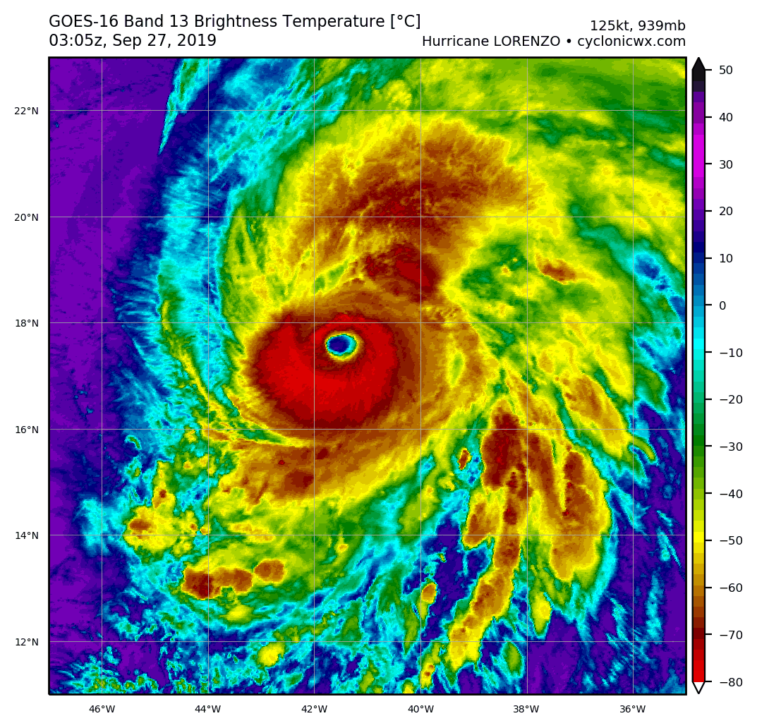
aperson wrote:and in rolls the IR frame that says to me "ok that's a cat 5"
https://cdn.discordapp.com/attachments/625398299092058136/626983357796057088/goes16_ir-dvorak_13L_201909270315.png
I doubt NHC will upgrade on a TC Update or Special Advisory unless it is crystal clear though. Just need the NW quad to thicken about 0.2 degrees for a clear-cut T7.0 (really more like T7.3 in that situation).
2 likes
-
CrazyC83
- Professional-Met
- Posts: 34315
- Joined: Tue Mar 07, 2006 11:57 pm
- Location: Deep South, for the first time!
Re: ATL: LORENZO - Hurricane - Discussion
There was an instantaneous T7.0 by one version of the ADT:
2019SEP27 014000 6.8 929.4 134.8 6.8 7.0 7.0 NO LIMIT OFF OFF 14.84 -73.07 EYE 25 IR 54.1 17.23 41.32 COMBO
2019SEP27 014000 6.8 929.4 134.8 6.8 7.0 7.0 NO LIMIT OFF OFF 14.84 -73.07 EYE 25 IR 54.1 17.23 41.32 COMBO
6 likes
-
1900hurricane
- Category 5
- Posts: 6063
- Age: 34
- Joined: Fri Feb 06, 2015 12:04 pm
- Location: Houston, TX
- Contact:
Re: ATL: LORENZO - Hurricane - Discussion
5 likes
Contract Meteorologist. TAMU & MSST. Fiercely authentic, one of a kind. We are all given free will, so choose a life meant to be lived. We are the Masters of our own Stories.
Opinions expressed are mine alone.
Follow me on Twitter at @1900hurricane : Read blogs at https://1900hurricane.wordpress.com/
Opinions expressed are mine alone.
Follow me on Twitter at @1900hurricane : Read blogs at https://1900hurricane.wordpress.com/
-
Shell Mound
- Category 5
- Posts: 2432
- Age: 33
- Joined: Thu Sep 07, 2017 3:39 pm
- Location: St. Petersburg, FL → Scandinavia
Re: ATL: LORENZO - Hurricane - Discussion
CrazyC83 wrote:Seeing a large area of CMG, borderline CDG, on the southern side, but the cloud tops have warmed a tad on the northern side. If everything can wrap around though, we'd have a solid cat 5.
If I recall correctly, MICHAEL featured a similar convective pattern in its CDO as it rapidly intensified upon landfall in the FL Panhandle. IGOR (2010) also exhibited a similar CDO and peak temperature in the eye at its peak over the open Atlantic. Based on these data, I would say that LORENZO likely peaked at 130-135 knots, though it could have briefly attained Cat-5 status (140 knots). Perhaps the post-seasonal analysis will increase the intensity to at least 130 knots, based on satellite data.
0 likes
CVW / MiamiensisWx / Shell Mound
The posts in this forum are NOT official forecasts and should not be used as such. They are just the opinion of the poster and may or may not be backed by sound meteorological data. They are NOT endorsed by any professional institution or STORM2K. For official information, please refer to products from the NHC and NWS.
Re: ATL: LORENZO - Hurricane - Discussion
Shell Mound wrote:CrazyC83 wrote:Seeing a large area of CMG, borderline CDG, on the southern side, but the cloud tops have warmed a tad on the northern side. If everything can wrap around though, we'd have a solid cat 5.
If I recall correctly, MICHAEL featured a similar convective pattern in its CDO as it rapidly intensified upon landfall in the FL Panhandle. IGOR (2010) also exhibited a similar CDO and peak temperature in the eye at its peak over the open Atlantic. Based on these data, I would say that LORENZO likely peaked at 130-135 knots, though it could have briefly attained Cat-5 status (140 knots). Perhaps the post-seasonal analysis will increase the intensity to at least 130 knots, based on satellite data.
Why are you saying it’s already peaked?
0 likes
Re: ATL: LORENZO - Hurricane - Discussion
UW - CIMSS
ADVANCED DVORAK TECHNIQUE
ADT-Version 9.0
Tropical Cyclone Intensity Algorithm
----- Current Analysis -----
Date : 27 SEP 2019 Time : 042024 UTC
Lat : 17:49:11 N Lon : 41:33:36 W
CI# /Pressure/ Vmax
6.7 / 929.8mb/132.2kt
Final T# Adj T# Raw T#
6.7 6.7 6.7
Estimated radius of max. wind based on IR : 24 km
Center Temp : +16.5C Cloud Region Temp : -70.6C
Scene Type : EYE
Subtropical Adjustment : OFF
Extratropical Adjustment : OFF
Positioning Method : ARCHER POSITIONING
Ocean Basin : ATLANTIC
Dvorak CI > MSLP Conversion Used : CKZ Method
Tno/CI Rules : Constraint Limits : NO LIMIT
Weakening Flag : OFF
Rapid Dissipation Flag : OFF
C/K/Z MSLP Estimate Inputs :
- Average 34 knot radii : 155nmi
- Environmental MSLP : 1012mb
Satellite Name : GOES16
Satellite Viewing Angle : 43.5 degrees
7 likes
-
Shell Mound
- Category 5
- Posts: 2432
- Age: 33
- Joined: Thu Sep 07, 2017 3:39 pm
- Location: St. Petersburg, FL → Scandinavia
Re: ATL: LORENZO - Hurricane - Discussion
wx98 wrote:Shell Mound wrote:CrazyC83 wrote:Seeing a large area of CMG, borderline CDG, on the southern side, but the cloud tops have warmed a tad on the northern side. If everything can wrap around though, we'd have a solid cat 5.
If I recall correctly, MICHAEL featured a similar convective pattern in its CDO as it rapidly intensified upon landfall in the FL Panhandle. IGOR (2010) also exhibited a similar CDO and peak temperature in the eye at its peak over the open Atlantic. Based on these data, I would say that LORENZO likely peaked at 130-135 knots, though it could have briefly attained Cat-5 status (140 knots). Perhaps the post-seasonal analysis will increase the intensity to at least 130 knots, based on satellite data.
Why are you saying it’s already peaked?
Stronger westerlies are already impinging on the northwestern semicircle, so LORENZO should begin to slowly weaken within a day, despite warming SSTs.
1 likes
CVW / MiamiensisWx / Shell Mound
The posts in this forum are NOT official forecasts and should not be used as such. They are just the opinion of the poster and may or may not be backed by sound meteorological data. They are NOT endorsed by any professional institution or STORM2K. For official information, please refer to products from the NHC and NWS.
-
Stormi

- Tropical Depression

- Posts: 86
- Age: 38
- Joined: Sun Aug 18, 2019 10:04 pm
- Location: Northeast FL
Re: ATL: LORENZO - Hurricane - Discussion
It appears sheared to the WNW to me...could be wrong as I'm a newbie. Other areas look stronger though to me
1 likes
-
NotSparta

- Professional-Met
- Posts: 1676
- Age: 24
- Joined: Fri Aug 18, 2017 8:24 am
- Location: Naples, FL
- Contact:
Re: ATL: LORENZO - Hurricane - Discussion
Making a move to the N, may be a wobble though
5 likes
This post was probably an opinion of mine, and in no way is official. Please refer to http://www.hurricanes.gov for official tropical analysis and advisories.
My website, with lots of tropical wx graphics, including satellite and recon: http://cyclonicwx.com
My website, with lots of tropical wx graphics, including satellite and recon: http://cyclonicwx.com

Re: ATL: LORENZO - Hurricane - Discussion
Wow, Lorenzo is looking pretty powerful! Sure, it might not get classified as Category 5 unless it's CDO gets even more symmetric and the eye more round. I think Igor 2010 is a good comparison.
Also, this storm may be a case like Edouard 1996, which was kept as Cat 4 even though he looked like a 5 to me at its peak. With no recon, it is hard to get a 5 far east in this basin lol.
Also, this storm may be a case like Edouard 1996, which was kept as Cat 4 even though he looked like a 5 to me at its peak. With no recon, it is hard to get a 5 far east in this basin lol.
3 likes
Georges '98, Irene '99, Frances '04, Jeanne '04, Katrina '05, Wilma '05, Gustav '08, Isaac '12, Matthew '16, Florence '18, Michael '18, Ian '22
-
Yellow Evan

- Professional-Met
- Posts: 16222
- Age: 27
- Joined: Fri Jul 15, 2011 12:48 pm
- Location: Henderson, Nevada/Honolulu, HI
- Contact:
Re: ATL: LORENZO - Hurricane - Discussion
aperson wrote:and in rolls the IR frame that says to me "ok that's a cat 5"
https://cdn.discordapp.com/attachments/625398299092058136/626983357796057088/goes16_ir-dvorak_13L_201909270315.png
That frame might not even qualify as T6.5.
This is basically an EPAC esque strong Cat 4.
3 likes
Who is online
Users browsing this forum: No registered users and 10 guests