Yellow Evan wrote:This is basically an EPAC esque strong Cat 4.
so 125 kt then, right?
Moderator: S2k Moderators


Yellow Evan wrote:This is basically an EPAC esque strong Cat 4.


NotSparta wrote:Making a move to the N, may be a wobble though
https://uploads.disquscdn.com/images/9d90a151ddac8990c244116db9c17c60c9ef0a34f56dd18ad22e1f93a8ffaaf9.gif


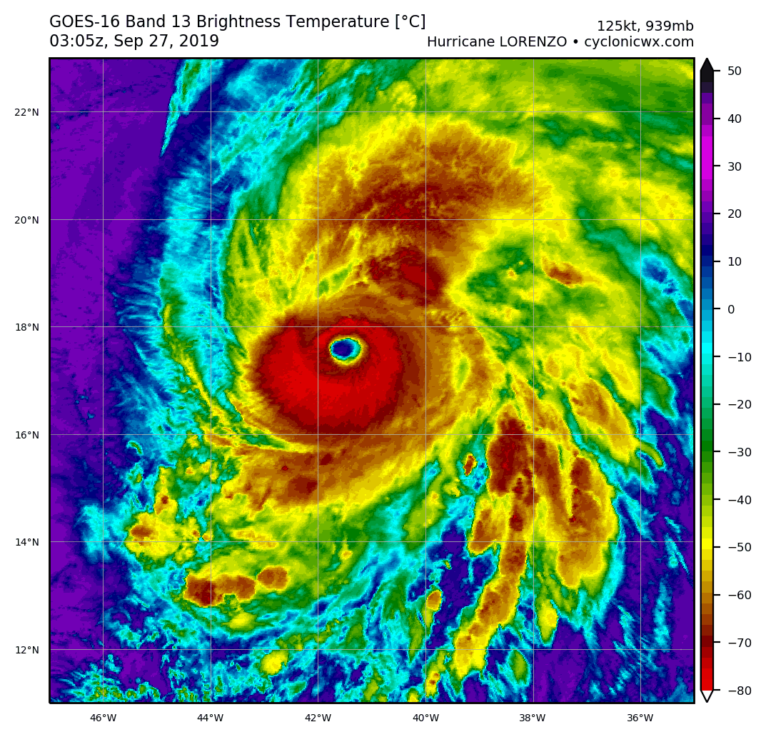
1900hurricane wrote:The difference between eye temp and CDO temp (via ADT) right now is 88.66ºC, which is getting up there. An 89-90ºC difference is usually a pretty good indication of a potential category 5 in the western hemisphere. In fact, since 2003, only one western hemisphere system has ever surpassed the 90ºC difference between the two and not been rated a category 5: Hurricane Barbara earlier this year (93.14ºC difference). Dorian maxed out at an 89.52ºC differential, and the biggest was from Haiyan '13 with a 106.06ºC, just for reference.
https://i.imgur.com/7MB1ezh.png

Chris90 wrote:NotSparta wrote:Making a move to the N, may be a wobble though
https://uploads.disquscdn.com/images/9d90a151ddac8990c244116db9c17c60c9ef0a34f56dd18ad22e1f93a8ffaaf9.gif
Is the rainbow IR imagery on your site new? I don't remember seeing it before. I haven't been paying much attention to the tropics since Dorian though due to life requiring attention in other areas. All I know is that I'm thrilled to see this, as the rainbow imagery is my favorite and I thought I was going to have to live without a good source for it. You've made my day by adding that to your site.


CrazyC83 wrote:Homie J wrote:CrazyC83 wrote:
That would be closer to T7.5 if the white ring can thicken since there is plenty of CMG and a warm eye. Even a dot of CDG in there.
what does CMG and CDG mean?
Cold medium gray (second coldest cloud top color, there's a lot of it) and cold dark gray (coldest cloud top, a pixel or two has popped up occasionally). For reference, if there was a solid CDG ring we'd have an easy T8.0.
Users browsing this forum: No registered users and 6 guests

