WPAC: HAGIBIS - Post-Tropical

Moderator: S2k Moderators

Message
Author
User avatar
1900hurricane
Category 5
Category 5
Posts: 6059
Age: 34
Joined: Fri Feb 06, 2015 12:04 pm
Location: Houston, TX
Contact:

Re: WPAC: HAGIBIS - Typhoon

#201 Postby 1900hurricane » Sun Oct 06, 2019 6:20 pm

mrbagyo wrote:
1900hurricane wrote:I realize this is a pipe dream since there is a struggle to keep the one NEXRAD on Guam operating normally sometimes (what a debacle with Yutu that was last year), but I really wish there could be a second NEXRAD on Saipan. That would really extend Mariana radar coverage.


I second that statement. Btw, what's the max range of this kind of radar. Some of radars used by CMA can cover 460 kms

About the same. Normal 0.50º base reflectivity extends out to 124 nm (230 km) with very good quality (although obviously better closer to the radar site), but returns are possible beyond that with taller storms (since the beam starts to get pretty high) up to 248 nm (460 km). Okinawa also has a NEXRAD and South Korea has two of them as well.
1 likes   
Contract Meteorologist. TAMU & MSST. Fiercely authentic, one of a kind. We are all given free will, so choose a life meant to be lived. We are the Masters of our own Stories.
Opinions expressed are mine alone.

Follow me on Twitter at @1900hurricane : Read blogs at https://1900hurricane.wordpress.com/

User avatar
Highteeld
Category 5
Category 5
Posts: 2139
Age: 41
Joined: Tue Jan 30, 2018 9:10 pm
Location: Chicago

Re: WPAC: HAGIBIS - Typhoon

#202 Postby Highteeld » Sun Oct 06, 2019 6:27 pm

I mean, I suppose you can make an argument for White embedded in White or Cold Medium Grey... either way, I think we are at the point where "Eye Pattern" is appropriate.

Would theoretically be an instantaneous T 5.5, or 102 knots, if I'm not mistakin'.

Image
Last edited by Highteeld on Sun Oct 06, 2019 6:32 pm, edited 1 time in total.
1 likes   
Very useful information on the Dvorak Technique --

https://severe.worldweather.wmo.int/TCF ... kBeven.pdf

User avatar
mrbagyo
Category 5
Category 5
Posts: 3715
Age: 33
Joined: Thu Apr 12, 2012 9:18 am
Location: 14.13N 120.98E
Contact:

Re: WPAC: HAGIBIS - Typhoon

#203 Postby mrbagyo » Sun Oct 06, 2019 6:30 pm

1900hurricane wrote:
mrbagyo wrote:
1900hurricane wrote:I realize this is a pipe dream since there is a struggle to keep the one NEXRAD on Guam operating normally sometimes (what a debacle with Yutu that was last year), but I really wish there could be a second NEXRAD on Saipan. That would really extend Mariana radar coverage.


I second that statement. Btw, what's the max range of this kind of radar. Some of radars used by CMA can cover 460 kms

About the same. Normal 0.50º base reflectivity extends out to 124 nm (230 km) with very good quality (although obviously better closer to the radar site), but returns are possible beyond that with taller storms (since the beam starts to get pretty high) up to 248 nm (460 km). Okinawa also has a NEXRAD and South Korea has two of them as well.


Thanks
1 likes   
The posts in this forum are NOT official forecast and should not be used as such. They are just the opinion of the poster and may or may not be backed by sound meteorological data. They are NOT endorsed by any professional institution or storm2k.org. For official information, please refer to RSMC, NHC and NWS products.

User avatar
Highteeld
Category 5
Category 5
Posts: 2139
Age: 41
Joined: Tue Jan 30, 2018 9:10 pm
Location: Chicago

Re: WPAC: HAGIBIS - Typhoon

#204 Postby Highteeld » Sun Oct 06, 2019 6:36 pm

I know I am repeating the sentiments of others, and probably sound like a broken record myself, but dear lord this thing is getting its act together at just an absurdly fast rate.
0 likes   
Very useful information on the Dvorak Technique --

https://severe.worldweather.wmo.int/TCF ... kBeven.pdf

User avatar
Ptarmigan
Category 5
Category 5
Posts: 5313
Joined: Wed Aug 16, 2006 9:06 pm

Re: WPAC: HAGIBIS - Typhoon

#205 Postby Ptarmigan » Sun Oct 06, 2019 6:38 pm

Cunxi Huang wrote:Actually UK goes as low as 873 mb. Don't thank me. :wink:

WP, 20, 2019100612, 03, UKM, 114, 252N, 1335E, 109, 873, TY, 34, NEQ, 258, 235, 214, 252, , , 32, , , W, , , , , HAGIBIS, 0, , 0, , 0, 0, 0, 0,


That is within Patricia or Tip territory.
0 likes   

User avatar
1900hurricane
Category 5
Category 5
Posts: 6059
Age: 34
Joined: Fri Feb 06, 2015 12:04 pm
Location: Houston, TX
Contact:

Re: WPAC: HAGIBIS - Typhoon

#206 Postby 1900hurricane » Sun Oct 06, 2019 6:48 pm

I mean, Emanuel's MPI is >200 kt/<850 mb and it has basically perfect conditions. This is kinda nuts.
1 likes   
Contract Meteorologist. TAMU & MSST. Fiercely authentic, one of a kind. We are all given free will, so choose a life meant to be lived. We are the Masters of our own Stories.
Opinions expressed are mine alone.

Follow me on Twitter at @1900hurricane : Read blogs at https://1900hurricane.wordpress.com/

User avatar
Highteeld
Category 5
Category 5
Posts: 2139
Age: 41
Joined: Tue Jan 30, 2018 9:10 pm
Location: Chicago

Re: WPAC: HAGIBIS - Typhoon

#207 Postby Highteeld » Sun Oct 06, 2019 6:51 pm

1900hurricane wrote:I mean, Emanuel's MPI is >200 kt/<850 mb and it has basically perfect conditions. This is kinda nuts.

This was an invest yesterday morning, right?
0 likes   
Very useful information on the Dvorak Technique --

https://severe.worldweather.wmo.int/TCF ... kBeven.pdf

User avatar
1900hurricane
Category 5
Category 5
Posts: 6059
Age: 34
Joined: Fri Feb 06, 2015 12:04 pm
Location: Houston, TX
Contact:

Re: WPAC: HAGIBIS - Typhoon

#208 Postby 1900hurricane » Sun Oct 06, 2019 6:54 pm

Highteeld wrote:
1900hurricane wrote:I mean, Emanuel's MPI is >200 kt/<850 mb and it has basically perfect conditions. This is kinda nuts.

This was an invest yesterday morning, right?

Heh, it almost feels like it, but not quite. It's almost 00Z now, and it got named 18Z yesterday (1 pm CDT), so that's just 30 hours from becoming a TS to what it's doing now. JTWC maintained it as a TD for 12 hours prior to it being classified as a TS, which happened at the same time (18Z October 5th) JMA named it.
0 likes   
Contract Meteorologist. TAMU & MSST. Fiercely authentic, one of a kind. We are all given free will, so choose a life meant to be lived. We are the Masters of our own Stories.
Opinions expressed are mine alone.

Follow me on Twitter at @1900hurricane : Read blogs at https://1900hurricane.wordpress.com/

User avatar
Highteeld
Category 5
Category 5
Posts: 2139
Age: 41
Joined: Tue Jan 30, 2018 9:10 pm
Location: Chicago

Re: WPAC: HAGIBIS - Typhoon

#209 Postby Highteeld » Sun Oct 06, 2019 6:56 pm

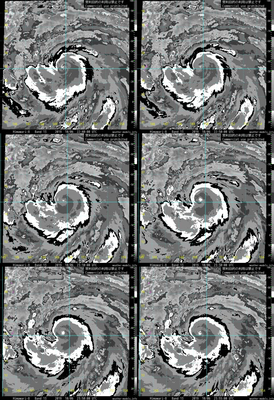
Subtle warming going on in the eye. Some Black pixels likely to break through on Dvorak soon.

Image
0 likes   
Very useful information on the Dvorak Technique --

https://severe.worldweather.wmo.int/TCF ... kBeven.pdf

User avatar
Highteeld
Category 5
Category 5
Posts: 2139
Age: 41
Joined: Tue Jan 30, 2018 9:10 pm
Location: Chicago

Re: WPAC: HAGIBIS - Typhoon

#210 Postby Highteeld » Sun Oct 06, 2019 6:57 pm

1900hurricane wrote:
Highteeld wrote:
1900hurricane wrote:I mean, Emanuel's MPI is >200 kt/<850 mb and it has basically perfect conditions. This is kinda nuts.

This was an invest yesterday morning, right?

Heh, it almost feels like it, but not quite. It's almost 00Z now, and it got named 18Z yesterday (1 pm CDT), so that's just 30 hours from becoming a TS to what it's doing now. JTWC maintained it as a TD for 12 hours prior to it being classified as a TS, which happened at the same time (18Z October 5th) JMA named it.

Figures. Never seen a storm develop at such a vigorous pace, which is throwing my sense of time off LOL.
0 likes   
Very useful information on the Dvorak Technique --

https://severe.worldweather.wmo.int/TCF ... kBeven.pdf

User avatar
Highteeld
Category 5
Category 5
Posts: 2139
Age: 41
Joined: Tue Jan 30, 2018 9:10 pm
Location: Chicago

Re: WPAC: HAGIBIS - Typhoon

#211 Postby Highteeld » Sun Oct 06, 2019 7:01 pm

Highteeld wrote:Subtle warming going on in the eye. Some Black pixels likely to break through on Dvorak soon.

https://i.imgur.com/dUVj0hc.png

Wasting no time in typical "Hagibis" fashion. :D

Image
0 likes   
Very useful information on the Dvorak Technique --

https://severe.worldweather.wmo.int/TCF ... kBeven.pdf

User avatar
1900hurricane
Category 5
Category 5
Posts: 6059
Age: 34
Joined: Fri Feb 06, 2015 12:04 pm
Location: Houston, TX
Contact:

Re: WPAC: HAGIBIS - Typhoon

#212 Postby 1900hurricane » Sun Oct 06, 2019 7:02 pm

Highteeld wrote:
1900hurricane wrote:
Highteeld wrote:This was an invest yesterday morning, right?

Heh, it almost feels like it, but not quite. It's almost 00Z now, and it got named 18Z yesterday (1 pm CDT), so that's just 30 hours from becoming a TS to what it's doing now. JTWC maintained it as a TD for 12 hours prior to it being classified as a TS, which happened at the same time (18Z October 5th) JMA named it.

Figures. Never seen a storm develop at such a vigorous pace, which is throwing my sense of time off LOL.

Technically if you use only CDT, it became a JTWC TD at 1 am yesterday, so you could still salvage a win. All about data framing.
0 likes   
Contract Meteorologist. TAMU & MSST. Fiercely authentic, one of a kind. We are all given free will, so choose a life meant to be lived. We are the Masters of our own Stories.
Opinions expressed are mine alone.

Follow me on Twitter at @1900hurricane : Read blogs at https://1900hurricane.wordpress.com/

User avatar
1900hurricane
Category 5
Category 5
Posts: 6059
Age: 34
Joined: Fri Feb 06, 2015 12:04 pm
Location: Houston, TX
Contact:

Re: WPAC: HAGIBIS - Typhoon

#213 Postby 1900hurricane » Sun Oct 06, 2019 7:03 pm

I'm going to be so sad when JTWC goes like 80 kt at 00Z.
2 likes   
Contract Meteorologist. TAMU & MSST. Fiercely authentic, one of a kind. We are all given free will, so choose a life meant to be lived. We are the Masters of our own Stories.
Opinions expressed are mine alone.

Follow me on Twitter at @1900hurricane : Read blogs at https://1900hurricane.wordpress.com/

User avatar
Highteeld
Category 5
Category 5
Posts: 2139
Age: 41
Joined: Tue Jan 30, 2018 9:10 pm
Location: Chicago

Re: WPAC: HAGIBIS - Typhoon

#214 Postby Highteeld » Sun Oct 06, 2019 7:05 pm

Last hour and a half:

Image
0 likes   
Very useful information on the Dvorak Technique --

https://severe.worldweather.wmo.int/TCF ... kBeven.pdf

User avatar
mrbagyo
Category 5
Category 5
Posts: 3715
Age: 33
Joined: Thu Apr 12, 2012 9:18 am
Location: 14.13N 120.98E
Contact:

Re: WPAC: HAGIBIS - Typhoon

#215 Postby mrbagyo » Sun Oct 06, 2019 7:14 pm

You don't see this often from the conservative JMA model.
Image
0 likes   
The posts in this forum are NOT official forecast and should not be used as such. They are just the opinion of the poster and may or may not be backed by sound meteorological data. They are NOT endorsed by any professional institution or storm2k.org. For official information, please refer to RSMC, NHC and NWS products.

User avatar
Highteeld
Category 5
Category 5
Posts: 2139
Age: 41
Joined: Tue Jan 30, 2018 9:10 pm
Location: Chicago

Re: WPAC: HAGIBIS - Typhoon

#216 Postby Highteeld » Sun Oct 06, 2019 7:16 pm

Focused in on the eye here:

Image
0 likes   
Very useful information on the Dvorak Technique --

https://severe.worldweather.wmo.int/TCF ... kBeven.pdf

User avatar
Cunxi Huang
Category 1
Category 1
Posts: 329
Age: 27
Joined: Thu Sep 26, 2013 12:17 pm
Location: San Jose, CA
Contact:

Re: WPAC: HAGIBIS - Typhoon

#217 Postby Cunxi Huang » Sun Oct 06, 2019 7:20 pm

ok so 00Z SATCON and AMSU are suggesting 961 mb and 941 mb respectively, I would say Hagibis is at least around 950 mb now.

2019 WP 20 279.965 2019OCT06 231000 15.21 -149.75 2 961 89

CIMSS/NESDIS-USAF/NRL AMSU TC Intensity Estimation:
TYPHOON 20W
Sunday 06oct19 Time: 2127 UTC
Latitude: 15.07 Longitude: 150.29
Storm position corresponds to AMSU-A FOV 7 [1<--->30]
-----------------------------------------------------------------
| Estimated MSLP: 941 hPa
| Estimated Maximum Sustained Wind: 109 kts
| Estimate Confidence: Good ( +/- 9mb +/- 10kts )
-----------------------------------------------------------------
Storm is sub-sampled: Bias correction applied is -5.9 hPa
Channel 8 (~150 hPa) Tb Anomaly: 2.11
Channel 7 (~250 hPa) Tb Anomaly: 1.49
RMW: 9 km
RMW Source is: MW
Environmental Pressure: 1005
Satellite: NOAA-15
ATCF data for Month: 10 Day: 06 Time (UTC): 1800

For imagery, go to http://amsu.ssec.wisc.edu
For all comments and questions mailto:chrisv@ssec.wisc.edu
0 likes   
06 SuTY SAOMAI | 09 TY LINFA | 10 TY FANAPI | 10 SuTY MEGI | 16 SuTY MERANTI | 19 SuTY LEKIMA | 24 C2 FRANCINE
DO NOT use my posts for life and death decisions. For official information, please refer to products from your RSMC and national weather agency.

User avatar
1900hurricane
Category 5
Category 5
Posts: 6059
Age: 34
Joined: Fri Feb 06, 2015 12:04 pm
Location: Houston, TX
Contact:

Re: WPAC: HAGIBIS - Typhoon

#218 Postby 1900hurricane » Sun Oct 06, 2019 7:20 pm

0 likes   
Contract Meteorologist. TAMU & MSST. Fiercely authentic, one of a kind. We are all given free will, so choose a life meant to be lived. We are the Masters of our own Stories.
Opinions expressed are mine alone.

Follow me on Twitter at @1900hurricane : Read blogs at https://1900hurricane.wordpress.com/

User avatar
Highteeld
Category 5
Category 5
Posts: 2139
Age: 41
Joined: Tue Jan 30, 2018 9:10 pm
Location: Chicago

Re: WPAC: HAGIBIS - Typhoon

#219 Postby Highteeld » Sun Oct 06, 2019 7:25 pm

Ryan calling for an full-out, T-8/170 knots. Not that I blame him. This storm has the best conditions I have ever seen!

 https://twitter.com/RyanMaue/status/1181001890429112321


0 likes   
Very useful information on the Dvorak Technique --

https://severe.worldweather.wmo.int/TCF ... kBeven.pdf

User avatar
Hayabusa
Category 5
Category 5
Posts: 4349
Joined: Sun Sep 16, 2018 1:05 pm

Re: WPAC: HAGIBIS - Typhoon

#220 Postby Hayabusa » Sun Oct 06, 2019 7:26 pm

He did the same with Yutu just sayin :lol:
0 likes   
ヤンデレ女が寝取られるているのを見たい!!!
ECMWF ensemble NWPAC plots: https://ecmwfensnwpac.imgbb.com/
Multimodel NWPAC plots: https://multimodelnwpac.imgbb.com/
GFS Ensemble NWPAC plots (16 & 35 day forecast): https://gefsnwpac.imgbb.com/
Plots updated automatically


Return to “2019”

Who is online

Users browsing this forum: No registered users and 4 guests