


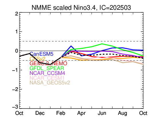
Shell Mound wrote:CyclonicFury wrote:BOM down to +0.32°C as well. The buoys show a developing tongue of cool anomalies in the Niño 3 region, and the warm subsurface anomalies have all but dissipated. The 30-day SOI average has increased to +1.6. Without any significant WWBs likely in the near future, the cooling seems likely to continue, and it may be a long time before +0.5°C is ever reached again.
However, FMA came in at +0.5°C, the fifth straight trimonthly value to reach the El Niño threshold. 2019-20 may be retroactively classified as a weak El Niño event.
What is your best estimate as to the earliest we may see trimonthly ONI values (NINO 3.4) in Niña territory in 2020? Based on current trends, while there likely won’t be any significant WWBs from now on, there also doesn’t appear to be any sustained period of well-above-average trades. I still don’t see any evidence that the CFSv2 and other bullish models will verify in regard to La Niña by ASO. Cool neutral ENSO seems to be the best bet at this point. This does make a difference in terms of steering, however, since cool neutral ENSO will likely feature less of a pronounced -PDO signature than weak La Niña or stronger. This would allow for more periods of +PNA-driven ridging along the West Coast, along with troughs along the Eastern Seaboard. Combined with an active MDR, this could imply less of a risk of landfalls on the CONUS. So ENSO conditions by ASO do matter.
I would say the absolute earliest we could see La Niña in JAS, maybe ASO. It's definitely not out of the question we could be in a weak La Niña by late summer if trades increase in strength in June/July.
I think you are overestimating the difference between cool neutral ENSO and weak La Niña ENSO. The ACE difference is negligible. For the Atlantic, the absence of El Niño is the most important.
As for landfalls, a paper from FSU suggests little difference between neutral and La Niña:
"Most previous ENSO impact studies have shown differences in hurricane activity between El Niño , neutral, and La Niña phases. In this study, differences are only observed in one out of the three phases. Along the East Coast, the effects of the El Niño and neutral phases are essentially the same, such that the scenario becomes El Niño/neutral vs. La Niña. Along the coasts of the Gulf of Mexico and Florida, there is a similar scenario. In this case, the effects of the La Niña and neutral phases are nearly identical, creating a La Niña/neutral vs. El Niño scenario."
Link to paper: https://climatecenter.fsu.edu/topics/tropical-weather/regional-effects-of-enso-on-us-hurricane-landfalls#El%20Nino/La%20Nina


