
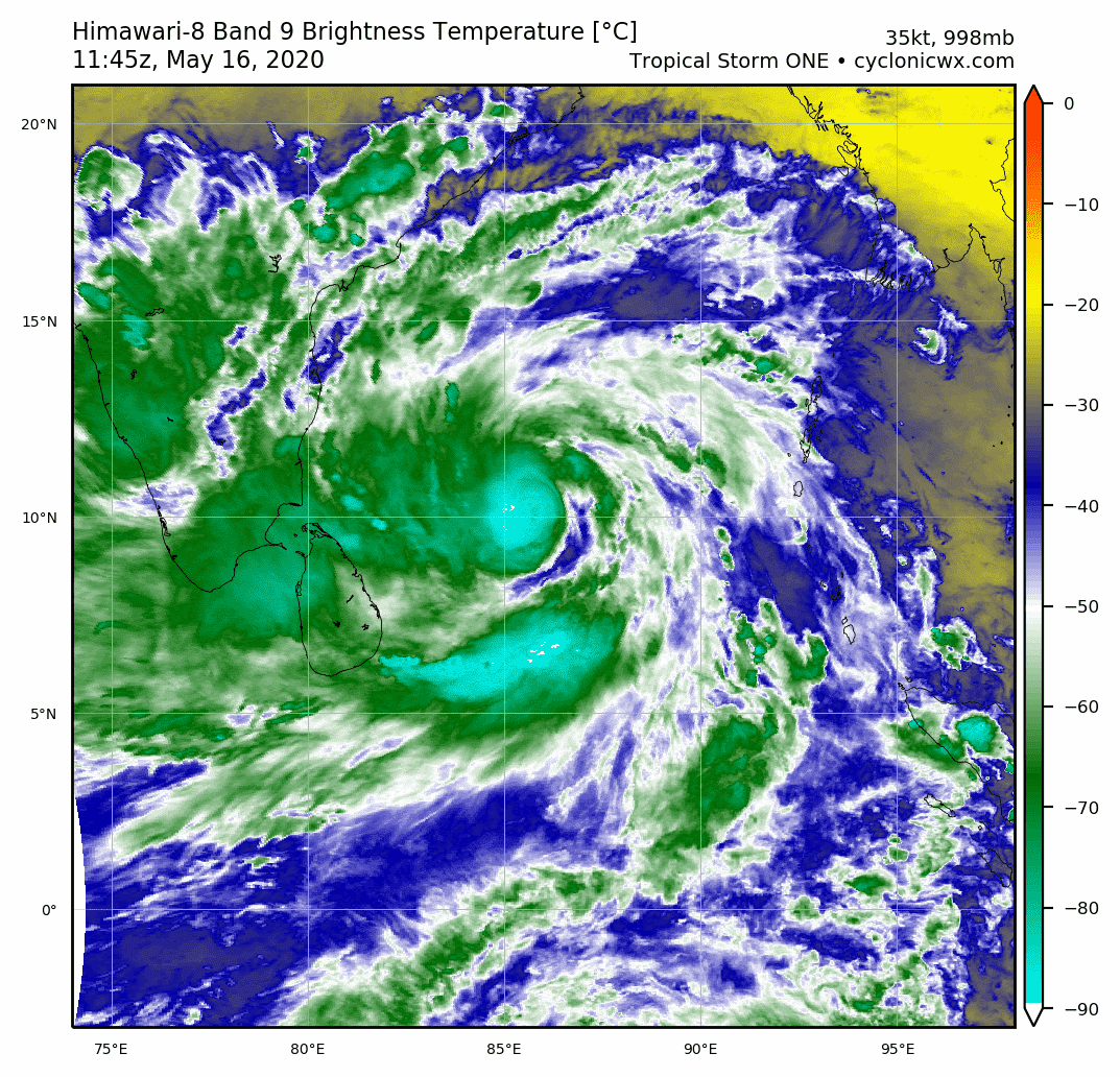
I see an eye starting to pop out. This thing is taking off really quickly. It’ll easily reach the JTWC’s peak of 85 kt sometime today at this rate.
BoB: AMPHAN - Post-Tropical
Moderator: S2k Moderators
Re: BoB: ONE-B - Deep Depression
I see an eye starting to pop out. This thing is taking off really quickly. It’ll easily reach the JTWC’s peak of 85 kt sometime today at this rate.
0 likes
Irene '11 Sandy '12 Hermine '16 5/15/2018 Derecho Fay '20 Isaias '20 Elsa '21 Henri '21 Ida '21
I am only a meteorology enthusiast who knows a decent amount about tropical cyclones. Look to the professional mets, the NHC, or your local weather office for the best information.
I am only a meteorology enthusiast who knows a decent amount about tropical cyclones. Look to the professional mets, the NHC, or your local weather office for the best information.

Re: BoB: ONE-B - Deep Depression
aspen wrote:
I see an eye starting to pop out. This thing is taking off really quickly. It’ll easily reach the JTWC’s peak of 85 kt sometime today at this rate.
In this case I don't think it's an eye quite yet. To me, it looks like an area of sink right next to the dominant hot tower
3 likes
Very useful information on the Dvorak Technique --
https://severe.worldweather.wmo.int/TCF ... kBeven.pdf
https://severe.worldweather.wmo.int/TCF ... kBeven.pdf
Re: BoB: ONE-B - Deep Depression
Latest met8. Very cold convection

0 likes
Very useful information on the Dvorak Technique --
https://severe.worldweather.wmo.int/TCF ... kBeven.pdf
https://severe.worldweather.wmo.int/TCF ... kBeven.pdf


Re: BoB: ONE-B - Deep Depression
Highteeld wrote:aspen wrote:
I see an eye starting to pop out. This thing is taking off really quickly. It’ll easily reach the JTWC’s peak of 85 kt sometime today at this rate.
In this case I don't think it's an eye quite yet. To me, it looks like an area of sink right next to the dominant hot tower
Well, I betting we’ll get one soon. Amphan is already very well organized with its center located well within that insanely cold (<-90 C) CDO, and its outflow is excellent as well.
0 likes
Irene '11 Sandy '12 Hermine '16 5/15/2018 Derecho Fay '20 Isaias '20 Elsa '21 Henri '21 Ida '21
I am only a meteorology enthusiast who knows a decent amount about tropical cyclones. Look to the professional mets, the NHC, or your local weather office for the best information.
I am only a meteorology enthusiast who knows a decent amount about tropical cyclones. Look to the professional mets, the NHC, or your local weather office for the best information.
-
1900hurricane

- Category 5

- Posts: 6063
- Age: 34
- Joined: Fri Feb 06, 2015 12:04 pm
- Location: Houston, TX
- Contact:
Re: BoB: ONE-B - Deep Depression
SMAP had 47 kt (10 minute? Don't know if NRL converts them or not) winds over 12 hours ago at 00Z.


Last edited by 1900hurricane on Sat May 16, 2020 10:03 am, edited 1 time in total.
0 likes
Contract Meteorologist. TAMU & MSST. Fiercely authentic, one of a kind. We are all given free will, so choose a life meant to be lived. We are the Masters of our own Stories.
Opinions expressed are mine alone.
Follow me on Twitter at @1900hurricane : Read blogs at https://1900hurricane.wordpress.com/
Opinions expressed are mine alone.
Follow me on Twitter at @1900hurricane : Read blogs at https://1900hurricane.wordpress.com/
Re: BoB: ONE-B - Deep Depression
Looks like Nesdis isn't doing any dvorak fixes. Did they get shutdown due to Coronavirus?
0 likes
Very useful information on the Dvorak Technique --
https://severe.worldweather.wmo.int/TCF ... kBeven.pdf
https://severe.worldweather.wmo.int/TCF ... kBeven.pdf
-
1900hurricane
- Category 5
- Posts: 6063
- Age: 34
- Joined: Fri Feb 06, 2015 12:04 pm
- Location: Houston, TX
- Contact:
Re: BoB: ONE-B - Deep Depression
Gotta love your ~90 mb tropopauses.

2 likes
Contract Meteorologist. TAMU & MSST. Fiercely authentic, one of a kind. We are all given free will, so choose a life meant to be lived. We are the Masters of our own Stories.
Opinions expressed are mine alone.
Follow me on Twitter at @1900hurricane : Read blogs at https://1900hurricane.wordpress.com/
Opinions expressed are mine alone.
Follow me on Twitter at @1900hurricane : Read blogs at https://1900hurricane.wordpress.com/
Re: BoB: ONE-B - Deep Depression
3000+ j/kg is nothing to sneeze at, either
0 likes
Very useful information on the Dvorak Technique --
https://severe.worldweather.wmo.int/TCF ... kBeven.pdf
https://severe.worldweather.wmo.int/TCF ... kBeven.pdf
-
Nancy Smar

- Category 5
- Posts: 1081
- Age: 25
- Joined: Wed Aug 16, 2017 10:03 pm
Re: BoB: ONE-B - Deep Depression
FKIN20 VIDP 161500
TC ADVISORY
TCAC: NEW DELHI
DTG: 20200516/1200Z
TC: AMPHAN
NR: 03
PSN: N1054 E08618
MOV: NNW03KT
C: 996HPA
MAX WIND: 035KT
FCST PSN+06HR: 16/1800Z N1106 E08606
FCST MAX WIND +6HRS: 040 KT
FCST PSN+12HR: 17/0000Z N1142 E08600
FCST MAX WIND +12HRS: 045 KT
FCST PSN+18HR: 17/0600Z N1212 E08600
FCST MAX WIND +18HRS: 050 KT
FCST PSN+24HR: 17/1200Z N1248 E08600
FCST MAX WIND +24HRS: 060 KT
RMK: NIL
NXT MSG: 20200516/2100Z
TOO: 162030HRS IST
1 likes

Re: BoB: INVEST 91B
TorSkk wrote:Abdullah wrote:TorSkk wrote:
You can find them here, on the RSMC New Delhi's website. Advisories are issued every three hours at at 00, 03, 06, 09, 12, 15, 18 and 21 UTC
http://www.rsmcnewdelhi.imd.gov.in/index.php?lang=en
Thanks for the link! I assume the three hour update is for full cyclones, though, right? For the invest, no update has been published since 6:00 UTC using data from 3:00 UTC of May 15. How often do we receive updates for invests?
A Tropical Weather Outlook is issued once a day at 6Z when there is no cyclone in the AOR. A Special Tropical Weather Outlook is issued twice a day (6Z and 15Z) when there is a Depression, and five times a day (3Z, 6Z, 9Z, 15Z, 21Z) when the Depression has intensified into a Deep Depression or is expected to intensify into one shortly. The previously mentioned Advisories are issued when it reaches cyclonic storm (TS) intensity
Thank you for the detailed response! As our last update was given at 15Z, we should have our next one by 21Z, now, right?
It's expected to be a deep depression by then.
0 likes
-
doomhaMwx

- Category 5
- Posts: 2487
- Age: 27
- Joined: Tue Apr 18, 2017 4:01 am
- Location: Baguio/Benguet, Philippines
- Contact:
Re: BoB: AMPHAN - Cyclonic Storm
This would've been named "Nisarga" if IMD hadn't underestimated TS 07A last season. That name is eerily reminiscent of Nargis(2008).
Ugh hopefully I'm just overthinking.
Ugh hopefully I'm just overthinking.
2 likes
Re: BoB: INVEST 91B
Abdullah wrote:TorSkk wrote:Abdullah wrote:
Thanks for the link! I assume the three hour update is for full cyclones, though, right? For the invest, no update has been published since 6:00 UTC using data from 3:00 UTC of May 15. How often do we receive updates for invests?
A Tropical Weather Outlook is issued once a day at 6Z when there is no cyclone in the AOR. A Special Tropical Weather Outlook is issued twice a day (6Z and 15Z) when there is a Depression, and five times a day (3Z, 6Z, 9Z, 15Z, 21Z) when the Depression has intensified into a Deep Depression or is expected to intensify into one shortly. The previously mentioned Advisories are issued when it reaches cyclonic storm (TS) intensity
Thank you for the detailed response! As our last update was given at 15Z, we should have our next one by 21Z, now, right?
It's expected to be a deep depression by then.
It's been upgraded to a Cyclonic Storm and therefore the next advisory is scheduled for 18Z
1 likes
-
Yellow Evan

- Professional-Met

- Posts: 16222
- Age: 27
- Joined: Fri Jul 15, 2011 12:48 pm
- Location: Henderson, Nevada/Honolulu, HI
- Contact:
Re: BoB: AMPHAN - Cyclonic Storm
TPIO10 PGTW 161513
A. TROPICAL CYCLONE 01B (E OF INDIA)
B. 16/1415Z
C. 10.99N
D. 86.11E
E. FIVE/GOES-IO
F. T2.5/2.5/D2.5/24HRS STT: D0.5/03HRS
G. IR/EIR
H. REMARKS: 38A/PBO SBC/ANMTN. .40 WRAP ON LOG10 SPIRAL YIELDS
A 2.5 DT. MET YIELDS A 2.0 AND PT YIELDS A 2.5. DBO DT.
I. ADDITIONAL POSITIONS:
16/1038Z 9.98N 86.07E SSMS
16/1109Z 9.98N 86.38E SSMS
16/1204Z 10.47N 86.22E MMHS
BERMEA
DT should be T3.5. Not sure what the JTWC is doing.
0 likes
-
Yellow Evan
- Professional-Met
- Posts: 16222
- Age: 27
- Joined: Fri Jul 15, 2011 12:48 pm
- Location: Henderson, Nevada/Honolulu, HI
- Contact:


Re: BoB: AMPHAN - Cyclonic Storm

0 likes
ヤンデレ女が寝取られるているのを見たい!!!
ECMWF ensemble NWPAC plots: https://ecmwfensnwpac.imgbb.com/
Multimodel NWPAC plots: https://multimodelnwpac.imgbb.com/
GFS Ensemble NWPAC plots (16 & 35 day forecast): https://gefsnwpac.imgbb.com/
Plots updated automatically
ECMWF ensemble NWPAC plots: https://ecmwfensnwpac.imgbb.com/
Multimodel NWPAC plots: https://multimodelnwpac.imgbb.com/
GFS Ensemble NWPAC plots (16 & 35 day forecast): https://gefsnwpac.imgbb.com/
Plots updated automatically
-
BYG Jacob
Re: BoB: AMPHAN - Cyclonic Storm
UKMET killing 5 or 6 digit figures of people in their runs I see.
3 likes
Re: BoB: AMPHAN - Cyclonic Storm
Where’s a good recent microwave pass when you need one? I really want to see how Amphan’s eyewall is coming out.
0 likes
Irene '11 Sandy '12 Hermine '16 5/15/2018 Derecho Fay '20 Isaias '20 Elsa '21 Henri '21 Ida '21
I am only a meteorology enthusiast who knows a decent amount about tropical cyclones. Look to the professional mets, the NHC, or your local weather office for the best information.
I am only a meteorology enthusiast who knows a decent amount about tropical cyclones. Look to the professional mets, the NHC, or your local weather office for the best information.

Who is online
Users browsing this forum: No registered users and 17 guests