
2020 Indicators: SST's / SAL / MSLP / Steering / Shear / Instability / Sat Images
Moderator: S2k Moderators
Forum rules

The posts in this forum are NOT official forecasts and should not be used as such. They are just the opinion of the poster and may or may not be backed by sound meteorological data. They are NOT endorsed by any professional institution or STORM2K. For official information, please refer to products from the National Hurricane Center and National Weather Service.
-
StruThiO

- Category 3

- Posts: 821
- Age: 26
- Joined: Fri Sep 15, 2017 5:51 am
- Location: Currently Portland, OR. Raised in Jax, FL.
Re: 2020 Indicators: SST's / SAL / MSLP / Steering / Shear / Instability / Sat Images
I know this can change quickly but this seems kinda low for this time of year, to me anyways.....
1 likes
-
hurricanes1234
- Category 5

- Posts: 2908
- Joined: Sat Jul 28, 2012 6:19 pm
- Location: Trinidad and Tobago
Re: 2020 Indicators: SST's / SAL / MSLP / Steering / Shear / Instability / Sat Images
StruThiO wrote:sorry for spam but ?!?!?!?!?
https://twitter.com/JackSillin/status/1268230528643354625
Yup, I agree it's still completely uncertain at this point.
But I remember a scenario like that occurred in 2017 with Tropical Storm Bret when it skirted the southern Caribbean on June 19th.
0 likes
PLEASE NOTE: With the exception of information from weather agencies that I may copy and paste here, my posts will NEVER be official, since I am NOT a meteorologist. They are solely my amateur opinion, and may or may not be accurate. Therefore, please DO NOT use them as official details, particularly when making important decisions. Thank you.
-
Shell Mound
- Category 5
- Posts: 2432
- Age: 33
- Joined: Thu Sep 07, 2017 3:39 pm
- Location: St. Petersburg, FL → Scandinavia
Re: 2020 Indicators: SST's / SAL / MSLP / Steering / Shear / Instability / Sat Images
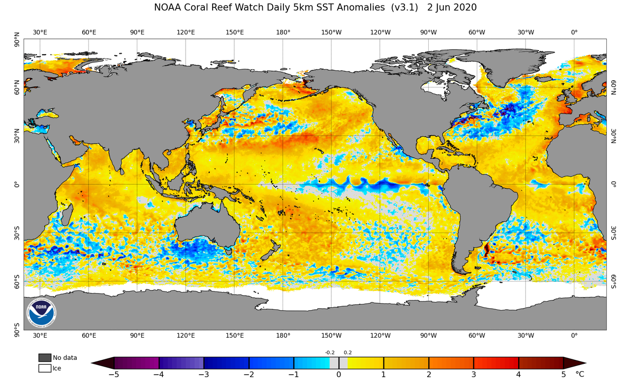
According to Tropical Tidbits, there is an expansive area of +1.5°–3.5°C (!) anomalies from just north of the Cabo Verde islands to the Bay of Biscay, based on CDAS data. Those are very robust anomalies for the Canary Current in early June. These anomalies, on the other hand, are located very close to the coastline of North Africa and Iberia. Typically, a +AMO exhibits the strongest warmth to the west of North Africa and Iberia, not along the immediate coastline, so the current configuration is not exactly prototypical. Still, the warmth is very impressive.
1 likes
CVW / MiamiensisWx / Shell Mound
The posts in this forum are NOT official forecasts and should not be used as such. They are just the opinion of the poster and may or may not be backed by sound meteorological data. They are NOT endorsed by any professional institution or STORM2K. For official information, please refer to products from the NHC and NWS.
-
Kingarabian

- S2K Supporter

- Posts: 16359
- Joined: Sat Aug 08, 2009 3:06 am
- Location: Honolulu, Hawaii
Re: 2020 Indicators: SST's / SAL / MSLP / Steering / Shear / Instability / Sat Images
StruThiO wrote:I know this can change quickly but this seems kinda low for this time of year, to me anyways.....
[url]https://i.imgur.com/LlZ7e50.jpg[url]
Was gonna post this yesterday. According to this chart, It definitely looks low.
0 likes
RIP Kobe Bryant

Re: 2020 Indicators: SST's / SAL / MSLP / Steering / Shear / Instability / Sat Images
Kingarabian wrote:StruThiO wrote:I know this can change quickly but this seems kinda low for this time of year, to me anyways.....
[url]https://i.imgur.com/LlZ7e50.jpg[url]
Was gonna post this yesterday. According to this chart, It definitely looks low.
Especially when you take into consideration that there was a change in the graphic with the new satellite that made it stand out more. Another interesting note is seeing that huge wave over Africa, 1996 and 2010 stand out for me as two years that had fairly strong waves coming off in early June.
0 likes
The above post is not official and should not be used as such. It is the opinion of the poster and may or may not be backed by sound meteorological data. It is not endorsed by any professional institution or storm2k.org. For official information, please refer to the NHC and NWS products.

Re: 2020 Indicators: SST's / SAL / MSLP / Steering / Shear / Instability / Sat Images
Hammy wrote:Kingarabian wrote:StruThiO wrote:I know this can change quickly but this seems kinda low for this time of year, to me anyways.....
[url]https://i.imgur.com/LlZ7e50.jpg[url]
Was gonna post this yesterday. According to this chart, It definitely looks low.
Especially when you take into consideration that there was a change in the graphic with the new satellite that made it stand out more. Another interesting note is seeing that huge wave over Africa, 1996 and 2010 stand out for me as two years that had fairly strong waves coming off in early June.
1996 and 2010 were both high-ACE seasons (166 and 165, specifically) with several long-tracking Cape Verde major hurricanes. Perhaps this is a sign that ACE could be in the 150-170 range with 5-6 major hurricanes, but it’s rather circumstantial evidence.
0 likes
Irene '11 Sandy '12 Hermine '16 5/15/2018 Derecho Fay '20 Isaias '20 Elsa '21 Henri '21 Ida '21
I am only a meteorology enthusiast who knows a decent amount about tropical cyclones. Look to the professional mets, the NHC, or your local weather office for the best information.
I am only a meteorology enthusiast who knows a decent amount about tropical cyclones. Look to the professional mets, the NHC, or your local weather office for the best information.
-
gatorcane

- S2K Supporter
- Posts: 23708
- Age: 48
- Joined: Sun Mar 13, 2005 3:54 pm
- Location: Boca Raton, FL
Re: 2020 Indicators: SST's / SAL / MSLP / Steering / Shear / Instability / Sat Images
Things indeed look like they can get quite active this season with cooler than normal SSTs in the subtropical Atlantic and above normal in the tropics. Also cooler than normal In tropical pacific.
2 likes
-
Kingarabian
- S2K Supporter
- Posts: 16359
- Joined: Sat Aug 08, 2009 3:06 am
- Location: Honolulu, Hawaii
Re: 2020 Indicators: SST's / SAL / MSLP / Steering / Shear / Instability / Sat Images
5 day SAL forecast:

Nothing a decently sized pouch can't handle.
Nothing a decently sized pouch can't handle.
0 likes
RIP Kobe Bryant
-
cycloneye

- Admin

- Posts: 149426
- Age: 69
- Joined: Thu Oct 10, 2002 10:54 am
- Location: San Juan, Puerto Rico
Re: 2020 Indicators: SST's / SAL / MSLP / Steering / Shear / Instability / Sat Images
This from the Phil KLotzbach discussion of the updated forecast.
The Atlantic had a relatively similar SST pattern in late March, although there
are also some significant differences (Figure 21). Over the past two months, the Atlantic
has been characterized by considerable anomalous cooling in the Gulf of Mexico, with
weak anomalous cooling in the tropical Atlantic. The subtropical Atlantic and far North
Atlantic have anomalously warmed (Figure 22). The Atlantic was generally characterized
by a positive North Atlantic Oscillation (NAO) during the winter of 2019/20, but in the
past few weeks, the NAO has trended more neutral, which has favored anomalous
warming in portions of the subtropical Atlantic and anomalous cooling off of the US East
Coast (Figure 23). Overall, the current SST anomaly pattern correlates relatively well
with what is typically seen in active Atlantic hurricane seasons (Figure 24). Anomalous
warmth in the eastern Atlantic in May is typically associated with more active seasons.
1 likes
Visit the Caribbean-Central America Weather Thread where you can find at first post web cams,radars
and observations from Caribbean basin members Click Here
and observations from Caribbean basin members Click Here

Re: 2020 Indicators: SST's / SAL / MSLP / Steering / Shear / Instability / Sat Images
StruThiO wrote:https://twitter.com/cyclonicwx/status/1268583443744673792
Improbable but not impossible. This year? If Vegas wanted to give me 10-1 odds...... I'd hand 'em $10.00
0 likes
Andy D
(For official information, please refer to the NHC and NWS products.)
(For official information, please refer to the NHC and NWS products.)
-
ScottNAtlanta

- Category 5
- Posts: 2535
- Joined: Sat May 25, 2013 3:11 pm
- Location: Atlanta, GA
Re: 2020 Indicators: SST's / SAL / MSLP / Steering / Shear / Instability / Sat Images
Kingarabian wrote:StruThiO wrote:I know this can change quickly but this seems kinda low for this time of year, to me anyways.....
[url]https://i.imgur.com/LlZ7e50.jpg[url]
Was gonna post this yesterday. According to this chart, It definitely looks low.
I think this is indicative of a +AMM which would foster cross equatorial westerly winds stronger in the northern hemisphere. This has been driving moisture into the region all spring. That would definitely keep the dust to a minimum, and drive warmer water to the coast.
0 likes
The posts in this forum are NOT official forecast and should not be used as such. They are just the opinion of the poster and may or may not be backed by sound meteorological data. They are NOT endorsed by any professional institution or storm2k.org. For official information, please refer to the NHC and NWS products.
-
TheStormExpert
Re: 2020 Indicators: SST's / SAL / MSLP / Steering / Shear / Instability / Sat Images
StruThiO wrote:https://twitter.com/cyclonicwx/status/1268583443744673792
Impressive for only June 4th!
Almost warrants a mention by the NHC.
0 likes


-
gatorcane
- S2K Supporter
- Posts: 23708
- Age: 48
- Joined: Sun Mar 13, 2005 3:54 pm
- Location: Boca Raton, FL
Re: 2020 Indicators: SST's / SAL / MSLP / Steering / Shear / Instability / Sat Images
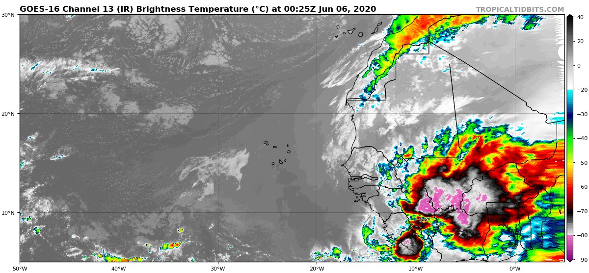
Another huge wave over Africa: 
6 likes
-
HurricaneEnzo

- Category 2

- Posts: 743
- Joined: Wed Mar 14, 2018 12:18 pm
- Location: Newport, NC (Hurricane Alley)
Re: RE: Re: 2020 Indicators: SST's / SAL / MSLP / Steering / Shear / Instability / Sat Images
Didn't figure the cool in the MDR was gonna be hanging around too long. It's really starting to look like this will be a season we remember for a long time.StruThiO wrote::eek:
Sent from my SM-N975U using Tapatalk
1 likes
Bertha 96' - Fran 96' - Bonnie 98' - Dennis 99' - Floyd 99' - Isabel 03' - Alex 04' - Ophelia 05' - Irene 11' - Arthur 14' - Matthew 16' - Florence 18' - Dorian 19' - Isaias 20' (countless other tropical storms and Hurricane swipes)
I am not a Professional Met just an enthusiast. Get your weather forecasts from the Pros!
I am not a Professional Met just an enthusiast. Get your weather forecasts from the Pros!
Re: 2020 Indicators: SST's / SAL / MSLP / Steering / Shear / Instability / Sat Images
gatorcane wrote:Another huge wave over Africa:
https://i.postimg.cc/VNgyv7t2/goes16-ir-eatl-202006060025.jpg
If we week getting giant waves like this, I would’ve be surprised if one of them develops into an early MDR system, maybe like Beryl ‘18.
1 likes
Irene '11 Sandy '12 Hermine '16 5/15/2018 Derecho Fay '20 Isaias '20 Elsa '21 Henri '21 Ida '21
I am only a meteorology enthusiast who knows a decent amount about tropical cyclones. Look to the professional mets, the NHC, or your local weather office for the best information.
I am only a meteorology enthusiast who knows a decent amount about tropical cyclones. Look to the professional mets, the NHC, or your local weather office for the best information.
Who is online
Users browsing this forum: No registered users and 24 guests