2020 EPAC Season

This is the general tropical discussion area. Anyone can take their shot at predicting a storms path.

Moderator: S2k Moderators

Forum rules

The posts in this forum are NOT official forecasts and should not be used as such. They are just the opinion of the poster and may or may not be backed by sound meteorological data. They are NOT endorsed by any professional institution or STORM2K. For official information, please refer to products from the National Hurricane Center and National Weather Service.

Help Support Storm2K
Message
Author
User avatar
Ubuntwo
Category 5
Category 5
Posts: 1406
Age: 31
Joined: Thu Oct 05, 2017 10:41 pm

Re: 2020 EPAC Season

#381 Postby Ubuntwo » Fri Jun 26, 2020 2:20 pm

TheStormExpert wrote:
cycloneye wrote:As eluded before,dead EPAC means Atlantic alive and active for ASO.

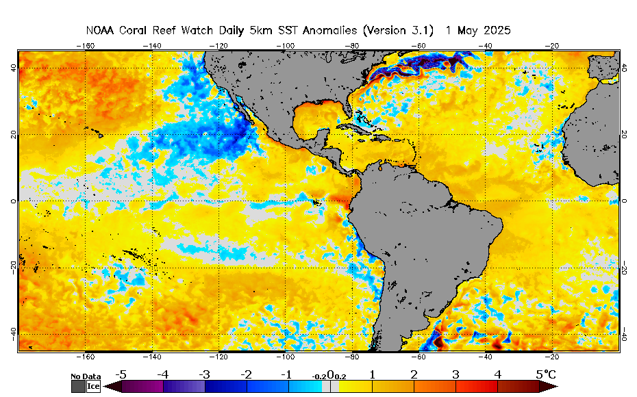
I’m sure the Atlantic will thrive, but how much will be determined on how quickly SST’s can rebound in the Tropical Atlantic. SAL is starting to erode the +AMO look.

Image
Rebound? Hardly a dent except for in the Caribbean
2 likes   
Kendall -> SLO -> PBC

Memorable Storms: Katrina (for its Florida landfall...) Wilma Matthew Irma

User avatar
Yellow Evan
Professional-Met
Professional-Met
Posts: 16143
Age: 27
Joined: Fri Jul 15, 2011 12:48 pm
Location: Henderson, Nevada/Honolulu, HI
Contact:

Re: 2020 EPAC Season

#382 Postby Yellow Evan » Fri Jun 26, 2020 2:30 pm

:uarrow: The EPAC config looks less favorable than 1-2 weeks ago as well.
0 likes   

TheStormExpert

Re: 2020 EPAC Season

#383 Postby TheStormExpert » Fri Jun 26, 2020 2:36 pm

Ubuntwo wrote:
TheStormExpert wrote:
cycloneye wrote:As eluded before,dead EPAC means Atlantic alive and active for ASO.

I’m sure the Atlantic will thrive, but how much will be determined on how quickly SST’s can rebound in the Tropical Atlantic. SAL is starting to erode the +AMO look.

https://coralreefwatch.noaa.gov/data/5km/v3.1/current/daily/gif/cur_coraltemp5km_ssta_west.gif
Rebound? Hardly a dent except for in the Caribbean

I’ll never understand why different sources make the SST’s look different. :lol:

What’s the link to this, so I can bookmark it?
0 likes   

User avatar
Ubuntwo
Category 5
Category 5
Posts: 1406
Age: 31
Joined: Thu Oct 05, 2017 10:41 pm

Re: 2020 EPAC Season

#384 Postby Ubuntwo » Fri Jun 26, 2020 2:53 pm

TheStormExpert wrote:
Ubuntwo wrote:
TheStormExpert wrote:I’m sure the Atlantic will thrive, but how much will be determined on how quickly SST’s can rebound in the Tropical Atlantic. SAL is starting to erode the +AMO look.

https://coralreefwatch.noaa.gov/data/5km/v3.1/current/daily/gif/cur_coraltemp5km_ssta_west.gif
Rebound? Hardly a dent except for in the Caribbean

I’ll never understand why different sources make the SST’s look different. :lol:

What’s the link to this, so I can bookmark it?

Coral Reef Watch: https://coralreefwatch.noaa.gov/product/5km/
or: https://coralreefwatch.noaa.gov/product ... %20average.
0 likes   
Kendall -> SLO -> PBC

Memorable Storms: Katrina (for its Florida landfall...) Wilma Matthew Irma

User avatar
Kingarabian
S2K Supporter
S2K Supporter
Posts: 15981
Joined: Sat Aug 08, 2009 3:06 am
Location: Honolulu, Hawaii

Re: 2020 EPAC Season

#385 Postby Kingarabian » Fri Jun 26, 2020 3:04 pm

This season may be one for the books.
3 likes   
RIP Kobe Bryant

User avatar
StruThiO
Category 3
Category 3
Posts: 821
Age: 25
Joined: Fri Sep 15, 2017 5:51 am
Location: Currently Portland, OR. Raised in Jax, FL.

Re: 2020 EPAC Season

#386 Postby StruThiO » Fri Jun 26, 2020 3:28 pm

Kingarabian wrote:This season may be one for the books.


:spam:
2 likes   

User avatar
Yellow Evan
Professional-Met
Professional-Met
Posts: 16143
Age: 27
Joined: Fri Jul 15, 2011 12:48 pm
Location: Henderson, Nevada/Honolulu, HI
Contact:

Re: 2020 EPAC Season

#387 Postby Yellow Evan » Fri Jun 26, 2020 3:54 pm

Kingarabian wrote:This season may be one for the books.


As if not enough things in the world have been cancelled this year.... :P
2 likes   

TheStormExpert

Re: 2020 EPAC Season

#388 Postby TheStormExpert » Fri Jun 26, 2020 5:22 pm

Kingarabian wrote:This season may be one for the books.

As in... NEXT! :lol:
1 likes   

Astromanía
Category 2
Category 2
Posts: 779
Age: 26
Joined: Sat Aug 25, 2018 10:34 pm
Location: Monterrey, N.L, México

Re: 2020 EPAC Season

#389 Postby Astromanía » Fri Jun 26, 2020 6:01 pm

Whatever, Amanda has a decent chance to be retired
0 likes   

TheStormExpert

Re: 2020 EPAC Season

#390 Postby TheStormExpert » Fri Jun 26, 2020 6:30 pm

Astromanía wrote:Whatever, Amanda has a decent chance to be retired

It likely will get retired for the same reasons the name it replaced did in 2008 (Alma).
0 likes   

User avatar
Yellow Evan
Professional-Met
Professional-Met
Posts: 16143
Age: 27
Joined: Fri Jul 15, 2011 12:48 pm
Location: Henderson, Nevada/Honolulu, HI
Contact:

Re: 2020 EPAC Season

#391 Postby Yellow Evan » Fri Jun 26, 2020 6:34 pm

Astromanía wrote:Whatever, Amanda has a decent chance to be retired


Given how random EPAC retirements can be, I have my doubts.
0 likes   

User avatar
cycloneye
Admin
Admin
Posts: 145330
Age: 68
Joined: Thu Oct 10, 2002 10:54 am
Location: San Juan, Puerto Rico

Re: 2020 EPAC Season

#392 Postby cycloneye » Sat Jun 27, 2020 6:47 am

Very boring.

Another area of disorganized showers and thunderstorms is located
several hundred miles off the coast of southwestern Mexico. This
system is expected to move northwestward at about 15 mph, parallel
to the coast of Mexico, and some development is possible before it
reaches cooler waters in a couple of days.
* Formation chance through 48 hours...low...20 percent.
* Formation chance through 5 days...low...30 percent.
1 likes   
Visit the Caribbean-Central America Weather Thread where you can find at first post web cams,radars
and observations from Caribbean basin members Click Here

User avatar
cycloneye
Admin
Admin
Posts: 145330
Age: 68
Joined: Thu Oct 10, 2002 10:54 am
Location: San Juan, Puerto Rico

Re: 2020 EPAC Season

#393 Postby cycloneye » Sat Jun 27, 2020 7:02 am

This basin in 2020 so far is below average on ACE with only 0.5 units while the normal units as of June 27 is 11.6.
0 likes   
Visit the Caribbean-Central America Weather Thread where you can find at first post web cams,radars
and observations from Caribbean basin members Click Here

User avatar
NotSparta
Professional-Met
Professional-Met
Posts: 1670
Age: 23
Joined: Fri Aug 18, 2017 8:24 am
Location: Naples, FL
Contact:

Re: 2020 EPAC Season

#394 Postby NotSparta » Sat Jun 27, 2020 1:39 pm

cycloneye wrote:This basin in 2020 so far is below average on ACE with only 0.5 units while the normal units as of June 27 is 11.6.


Fun fact: the EPAC has generated less ACE in the entire season so far than every Atlantic storm except Bertha
7 likes   
This post was probably an opinion of mine, and in no way is official. Please refer to http://www.hurricanes.gov for official tropical analysis and advisories.

My website, with lots of tropical wx graphics, including satellite and recon: http://cyclonicwx.com

User avatar
aspen
Category 5
Category 5
Posts: 8818
Joined: Sat Oct 12, 2019 7:10 pm
Location: Connecticut, USA

Re: 2020 EPAC Season

#395 Postby aspen » Sat Jun 27, 2020 2:05 pm

Perhaps that low ACE streak might end soon...

The GFS has been hinting at more EPac systems in the coming days. The first system forms at roughly 100W/10N in 138 hours, or just under a week, so it’s not too far out. This first system continues WNW and intensifies into a hurricane, and by 198 hours (only a few days later), another one puts itself together around 90W/10N. Past 200-240 hours, the GFS bombs this out to a sub-940 mbar Major Hurricane, but that is very unlikely as of now. System 2 will also move WNW similar to System 1, and the two of them, assuming they form and keep this track, will be passing over some nice and toasty waters for intensification into storms that aren’t pathetically weak and disorganized TCs like Amanda and Boris.
0 likes   
Irene '11 Sandy '12 Hermine '16 5/15/2018 Derecho Fay '20 Isaias '20 Elsa '21 Henri '21 Ida '21

I am only a meteorology enthusiast who knows a decent amount about tropical cyclones. Look to the professional mets, the NHC, or your local weather office for the best information.

User avatar
Yellow Evan
Professional-Met
Professional-Met
Posts: 16143
Age: 27
Joined: Fri Jul 15, 2011 12:48 pm
Location: Henderson, Nevada/Honolulu, HI
Contact:

Re: 2020 EPAC Season

#396 Postby Yellow Evan » Sat Jun 27, 2020 2:08 pm

With MJO leaving in a week or so, I have my doubts and don't trust the GFS in these situations.
2 likes   

User avatar
aspen
Category 5
Category 5
Posts: 8818
Joined: Sat Oct 12, 2019 7:10 pm
Location: Connecticut, USA

Re: 2020 EPAC Season

#397 Postby aspen » Sat Jun 27, 2020 2:25 pm

Yellow Evan wrote:With MJO leaving in a week or so, I have my doubts and don't trust the GFS in these situations.

Hey, at least it’s something.

I think the first system may be developing from one of the waves currently in the MDR. It’s been showing up for the last several runs now.
0 likes   
Irene '11 Sandy '12 Hermine '16 5/15/2018 Derecho Fay '20 Isaias '20 Elsa '21 Henri '21 Ida '21

I am only a meteorology enthusiast who knows a decent amount about tropical cyclones. Look to the professional mets, the NHC, or your local weather office for the best information.

User avatar
aspen
Category 5
Category 5
Posts: 8818
Joined: Sat Oct 12, 2019 7:10 pm
Location: Connecticut, USA

Re: 2020 EPAC Season

#398 Postby aspen » Sat Jun 27, 2020 3:46 pm

Global models are in good agreement with a low-latitude EPac system forming east of 110 W sometime next week. However, the exact time of development and future intensity vary wildly, to no one's surprise.

12z GFS develops at 138 hrs, and as the system tracks generally WNW, it brings it to hurricane status next weekend.
Image
Image

12z Euro is very tame with this system, but shows something weak at 144 hrs and a tropical storm by the end of its run. The fact that it's there is the only thing that matters at this point.
Image
Image

12z CMC develops the system earlier (126 hrs) and further east (94 W) than the GFS, and has it meander for a bit.
Image
Image

12z NAVGEM doesn't show much, but the system appears quite early at 114 hrs.
Image

12z ICON is surprisingly aggressive with development, having a TC in just 93 hours and near hurricane status in 141 hours.
Image
Image

If at least some of these models continues to show development tomorrow and the day after, the NHC will probably mark it as an area of interest.
1 likes   
Irene '11 Sandy '12 Hermine '16 5/15/2018 Derecho Fay '20 Isaias '20 Elsa '21 Henri '21 Ida '21

I am only a meteorology enthusiast who knows a decent amount about tropical cyclones. Look to the professional mets, the NHC, or your local weather office for the best information.

User avatar
Kingarabian
S2K Supporter
S2K Supporter
Posts: 15981
Joined: Sat Aug 08, 2009 3:06 am
Location: Honolulu, Hawaii

Re: 2020 EPAC Season

#399 Postby Kingarabian » Sat Jun 27, 2020 4:45 pm

Goes to show how tough things are in the EPAC that even when the GFS shows 3 strong hurricanes, no one is excited.
4 likes   
RIP Kobe Bryant

User avatar
cycloneye
Admin
Admin
Posts: 145330
Age: 68
Joined: Thu Oct 10, 2002 10:54 am
Location: San Juan, Puerto Rico

Re: 2020 EPAC Season

#400 Postby cycloneye » Sat Jun 27, 2020 6:34 pm

Tropical Weather Outlook
NWS National Hurricane Center Miami FL
500 PM PDT Sat Jun 27 2020

For the eastern North Pacific...east of 140 degrees west longitude:

1. An area of disorganized showers and thunderstorms is located
a few hundred miles off the coast of southwestern Mexico. This
system is expected to move northwestward at about 15 mph, parallel
to the coast of Mexico, and some development is possible before it
reaches cooler waters in a couple of days.
* Formation chance through 48 hours...low...20 percent.
* Formation chance through 5 days...low...20 percent.

Forecaster Latto
0 likes   
Visit the Caribbean-Central America Weather Thread where you can find at first post web cams,radars
and observations from Caribbean basin members Click Here


Return to “Talkin' Tropics”

Who is online

Users browsing this forum: lolitx and 55 guests