
2020 Indicators: SST's / SAL / MSLP / Steering / Shear / Instability / Sat Images
Moderator: S2k Moderators
Forum rules

The posts in this forum are NOT official forecasts and should not be used as such. They are just the opinion of the poster and may or may not be backed by sound meteorological data. They are NOT endorsed by any professional institution or STORM2K. For official information, please refer to products from the National Hurricane Center and National Weather Service.
-
TheStormExpert
Re: 2020 Indicators: SST's / SAL / MSLP / Steering / Shear / Instability / Sat Images
Dang! That's a lot of mid-level dry air out in the Atlantic, any thoughts?
0 likes

Re: 2020 Indicators: SST's / SAL / MSLP / Steering / Shear / Instability / Sat Images
TheStormExpert wrote:Dang! That's a lot of mid-level dry air out in the Atlantic, any thoughts?
https://i.imgur.com/SJdsYQz.jpg
It shouldn’t be a surprise, like mentioned many times the SAL is in control for now.
4 likes
-
StruThiO

- Category 3

- Posts: 821
- Age: 26
- Joined: Fri Sep 15, 2017 5:51 am
- Location: Currently Portland, OR. Raised in Jax, FL.
Re: 2020 Indicators: SST's / SAL / MSLP / Steering / Shear / Instability / Sat Images
TheStormExpert wrote:any thoughts?
Yeah. My thoughts are that it's mid July
8 likes
-
toad strangler

- S2K Supporter

- Posts: 4546
- Joined: Sun Jul 28, 2013 3:09 pm
- Location: Earth
- Contact:
Re: 2020 Indicators: SST's / SAL / MSLP / Steering / Shear / Instability / Sat Images
TheStormExpert wrote:Dang! That's a lot of mid-level dry air out in the Atlantic, any thoughts?
https://i.imgur.com/SJdsYQz.jpg
Yes, it’s July 11th
3 likes
My Weather Station
https://www.wunderground.com/dashboard/pws/KFLPORTS603
https://www.wunderground.com/dashboard/pws/KFLPORTS603
-
SFLcane

- S2K Supporter
- Posts: 10281
- Age: 48
- Joined: Sat Jun 05, 2010 1:44 pm
- Location: Lake Worth Florida
Re: 2020 Indicators: SST's / SAL / MSLP / Steering / Shear / Instability / Sat Images
TheStormExpert wrote:Dang! That's a lot of mid-level dry air out in the Atlantic, any thoughts?
https://i.imgur.com/SJdsYQz.jpg
Dry sinking air ( SAL) peaks in July.
0 likes
-
AnnularCane

- S2K Supporter
- Posts: 2962
- Joined: Thu Jun 08, 2006 9:18 am
- Location: Wytheville, VA
Re: 2020 Indicators: SST's / SAL / MSLP / Steering / Shear / Instability / Sat Images
TheStormExpert wrote:Chaserdude Josh Morgerman notorious for riding out Hurricane Dorian in Marsh Harbor last September is ready for anything that comes barreling towards the U.S.!
https://twitter.com/iCyclone/status/1282116120061849602
Now there's an intimidating stare!
He might scare the storms away with that.
1 likes
-
stormlover2013
Re: 2020 Indicators: SST's / SAL / MSLP / Steering / Shear / Instability / Sat Images
It’s July, give it 3 weeks then boom!!
0 likes
-
Shell Mound
- Category 5

- Posts: 2432
- Age: 33
- Joined: Thu Sep 07, 2017 3:39 pm
- Location: St. Petersburg, FL → Scandinavia
Re: 2020 Indicators: SST's / SAL / MSLP / Steering / Shear / Instability / Sat Images


0 likes
CVW / MiamiensisWx / Shell Mound
The posts in this forum are NOT official forecasts and should not be used as such. They are just the opinion of the poster and may or may not be backed by sound meteorological data. They are NOT endorsed by any professional institution or STORM2K. For official information, please refer to products from the NHC and NWS.

Re: 2020 Indicators: SST's / SAL / MSLP / Steering / Shear / Instability / Sat Images
TheStormExpert wrote:Dang! That's a lot of mid-level dry air out in the Atlantic, any thoughts?
https://i.imgur.com/SJdsYQz.jpg
That's a very 1999-esque look out there.

3 likes
The above post is not official and should not be used as such. It is the opinion of the poster and may or may not be backed by sound meteorological data. It is not endorsed by any professional institution or storm2k.org. For official information, please refer to the NHC and NWS products.
-
USTropics
- Professional-Met

- Posts: 2738
- Joined: Sun Aug 12, 2007 3:45 am
- Location: Florida State University
Re: 2020 Indicators: SST's / SAL / MSLP / Steering / Shear / Instability / Sat Images
Some significant warming has occurred in the GOM since the beginning of June:
June 1st

Current

Current SSTA global

SST trend past 7 days global

June 1st
Current
Current SSTA global
SST trend past 7 days global
4 likes
-
Shell Mound
- Category 5
- Posts: 2432
- Age: 33
- Joined: Thu Sep 07, 2017 3:39 pm
- Location: St. Petersburg, FL → Scandinavia
Re: 2020 Indicators: SST's / SAL / MSLP / Steering / Shear / Instability / Sat Images
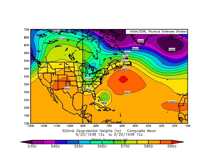
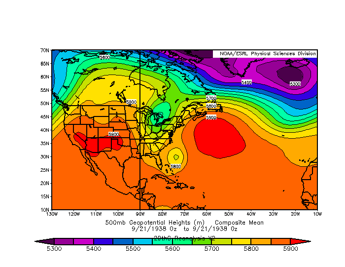
Shell Mound wrote:https://pbs.twimg.com/media/EcqtV0JXgAA-Ui1?format=jpg&name=small
https://www.weather.gov/images/okx/1938Hurricane/500mb_slp_19380920_12z.gif
https://www.weather.gov/images/okx/1938Hurricane/500mb_slp_19380921_00z.gif
https://upload.wikimedia.org/wikipedia/commons/thumb/e/e0/1938_Atlantic_hurricane_season_summary_map.png/600px-1938_Atlantic_hurricane_season_summary_map.png
https://upload.wikimedia.org/wikipedia/commons/thumb/3/3c/2020_Atlantic_hurricane_season_summary_map.png/600px-2020_Atlantic_hurricane_season_summary_map.png
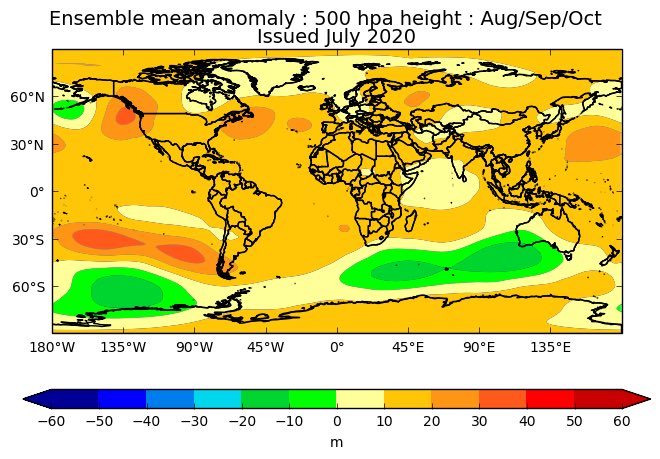
The latest UKMET forecast for ASO is eerily similar to the synoptic setup at the time of the 1938 New England hurricane.
0 likes
CVW / MiamiensisWx / Shell Mound
The posts in this forum are NOT official forecasts and should not be used as such. They are just the opinion of the poster and may or may not be backed by sound meteorological data. They are NOT endorsed by any professional institution or STORM2K. For official information, please refer to products from the NHC and NWS.
-
IsabelaWeather
- Category 1

- Posts: 316
- Age: 36
- Joined: Tue Jul 07, 2020 7:29 am
- Location: Isabela, Puerto Rico
Re: 2020 Indicators: SST's / SAL / MSLP / Steering / Shear / Instability / Sat Images
Not sure if this is the right thread for this or not, but the anemic/nearly dead tropical wave has exploded over the Island late overnight. Also seems to have some ever so slight rotation, likely just due to the land friction, but very interesting nonetheless.
3 likes
Re: 2020 Indicators: SST's / SAL / MSLP / Steering / Shear / Instability / Sat Images
Once the dust settles down, look out! The UL winds anomaly across the Caribbean and western MDR are very similar so far to this same time in 2017.


This same time last year UL westerly winds ripping through the Caribbean.

This same time last year UL westerly winds ripping through the Caribbean.
6 likes
-
hurricanes1234
- Category 5
- Posts: 2908
- Joined: Sat Jul 28, 2012 6:19 pm
- Location: Trinidad and Tobago
Re: 2020 Indicators: SST's / SAL / MSLP / Steering / Shear / Instability / Sat Images
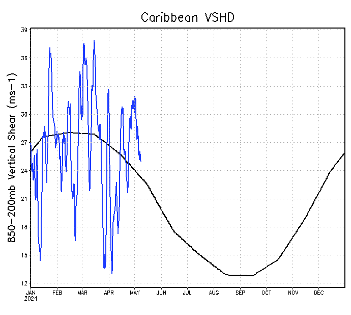
I don't know how to post an image but yesterday I looked at the deep-layer shear map and for the first time, I saw that many areas in the Caribbean were green (15 knots or less of deep-layer shear).
This is in stark contrast to even last month when there were reds everywhere and shear was completely ripping apart the first few tropical waves as soon as they approached the Eastern Caribbean.
This is in stark contrast to even last month when there were reds everywhere and shear was completely ripping apart the first few tropical waves as soon as they approached the Eastern Caribbean.
1 likes
PLEASE NOTE: With the exception of information from weather agencies that I may copy and paste here, my posts will NEVER be official, since I am NOT a meteorologist. They are solely my amateur opinion, and may or may not be accurate. Therefore, please DO NOT use them as official details, particularly when making important decisions. Thank you.

Re: 2020 Indicators: SST's / SAL / MSLP / Steering / Shear / Instability / Sat Images
NDG wrote:Once the dust settles down, look out! The UL winds anomaly across the Caribbean and western MDR are very similar so far to this same time in 2017.
https://i.imgur.com/Z0iDo1j.gif
https://i.imgur.com/3lBPoGQ.gif
This same time last year UL westerly winds ripping through the Caribbean.
https://i.imgur.com/LL3ZHoC.gif
2020’s shear pattern looks even more favorable than 2017’s. Not only is shear slightly less in the W Caribbean, but the Gulf is also quite favorable. This is in contrast to 2017’s Gulf blob of 6-7 m/s shear.
I’m starting to get a little worried about something big in the Gulf in late July or early August, once the dust settles down and AEWs are able to get that far.
5 likes
Irene '11 Sandy '12 Hermine '16 5/15/2018 Derecho Fay '20 Isaias '20 Elsa '21 Henri '21 Ida '21
I am only a meteorology enthusiast who knows a decent amount about tropical cyclones. Look to the professional mets, the NHC, or your local weather office for the best information.
I am only a meteorology enthusiast who knows a decent amount about tropical cyclones. Look to the professional mets, the NHC, or your local weather office for the best information.
-
Shell Mound
- Category 5
- Posts: 2432
- Age: 33
- Joined: Thu Sep 07, 2017 3:39 pm
- Location: St. Petersburg, FL → Scandinavia
Re: 2020 Indicators: SST's / SAL / MSLP / Steering / Shear / Instability / Sat Images
In general, the correlation between shear and Atlantic ACE is stronger in the Caribbean than it is in the tropical Atlantic. The relationship between shear and Atlantic hurricanes is much stronger in July than it is in June. –p. 32
3 likes
CVW / MiamiensisWx / Shell Mound
The posts in this forum are NOT official forecasts and should not be used as such. They are just the opinion of the poster and may or may not be backed by sound meteorological data. They are NOT endorsed by any professional institution or STORM2K. For official information, please refer to products from the NHC and NWS.
-
Aric Dunn
- Category 5
- Posts: 21238
- Age: 43
- Joined: Sun Sep 19, 2004 9:58 pm
- Location: Ready for the Chase.
- Contact:
Re: 2020 Indicators: SST's / SAL / MSLP / Steering / Shear / Instability / Sat Images
Just an FYI. Southern deserts of Mauritania, CHAD,Niger and Mali have all received their first measurable rain this past week. In areas that contribute to SAL..
That of course would lead to smaller SAL outbreaks.
Typically this happens around August
That of course would lead to smaller SAL outbreaks.
Typically this happens around August
7 likes
Note: If I make a post that is brief. Please refer back to previous posts for the analysis or reasoning. I do not re-write/qoute what my initial post said each time.
If there is nothing before... then just ask
Space & Atmospheric Physicist, Embry-Riddle Aeronautical University,
I believe the sky is falling...
If there is nothing before... then just ask
Space & Atmospheric Physicist, Embry-Riddle Aeronautical University,
I believe the sky is falling...
-
TheStormExpert
Re: 2020 Indicators: SST's / SAL / MSLP / Steering / Shear / Instability / Sat Images
NDG wrote:Once the dust settles down, look out! The UL winds anomaly across the Caribbean and western MDR are very similar so far to this same time in 2017.
https://i.imgur.com/Z0iDo1j.gif
https://i.imgur.com/3lBPoGQ.gif
This same time last year UL westerly winds ripping through the Caribbean.
https://i.imgur.com/LL3ZHoC.gif
If anything it looks more favorable especially in the Gulf. I was looking at the shear maps last night and things look quite favorable for at least mid-July.
0 likes
-
Aric Dunn
- Category 5
- Posts: 21238
- Age: 43
- Joined: Sun Sep 19, 2004 9:58 pm
- Location: Ready for the Chase.
- Contact:
Re: 2020 Indicators: SST's / SAL / MSLP / Steering / Shear / Instability / Sat Images
In fact it just rained today in the Bodélé Depression which is the main region where the SAL is produced.
with less SAL outbreaks easterly waves will be able to sustain as they traverse Africa. I suppose if you want to talk about indicators..
this is probably the top of the list...
main SAL location circled.

with less SAL outbreaks easterly waves will be able to sustain as they traverse Africa. I suppose if you want to talk about indicators..
this is probably the top of the list...
main SAL location circled.
5 likes
Note: If I make a post that is brief. Please refer back to previous posts for the analysis or reasoning. I do not re-write/qoute what my initial post said each time.
If there is nothing before... then just ask
Space & Atmospheric Physicist, Embry-Riddle Aeronautical University,
I believe the sky is falling...
If there is nothing before... then just ask
Space & Atmospheric Physicist, Embry-Riddle Aeronautical University,
I believe the sky is falling...
-
SFLcane
- S2K Supporter
- Posts: 10281
- Age: 48
- Joined: Sat Jun 05, 2010 1:44 pm
- Location: Lake Worth Florida
Re: 2020 Indicators: SST's / SAL / MSLP / Steering / Shear / Instability / Sat Images
NDG wrote:Once the dust settles down, look out! The UL winds anomaly across the Caribbean and western MDR are very similar so far to this same time in 2017.
https://i.imgur.com/Z0iDo1j.gif
https://i.imgur.com/3lBPoGQ.gif
This same time last year UL westerly winds ripping through the Caribbean.
https://i.imgur.com/LL3ZHoC.gif
It's not the shear that's the problem Stability/subsidence. Plus the Atlantic is nothing close to 2017 SSTwise. East Atlantic especially

1 likes
Who is online
Users browsing this forum: Blown Away, mixedDanilo.E and 49 guests