2020 Global Model Runs Discussion (Out thru day 16)
Moderator: S2k Moderators
Forum rules
The posts in this forum are NOT official forecasts and should not be used as such. They are just the opinion of the poster and may or may not be backed by sound meteorological data. They are NOT endorsed by any professional institution or STORM2K. For official information, please refer to products from the National Hurricane Center and National Weather Service.
-
TheStormExpert
Re: 2020 Global Model Runs Discussion (Out thru day 16)
At the moment in 10 days I highly doubt anything will be able to make it to the U.S. East Coast as both the GFS and CMC show a decent trough sitting just off the NE U.S. coast.


0 likes
Re: 2020 Global Model Runs Discussion (Out thru day 16)
East Coast is only a place to watch for things exiting the continent over the next week.
ICON has the convection coming into the Gulf across Florida that follows the low south of LA right now which is following the low off the TX Coast. It no longer wants to develop it until it's almost to the TX Coast. It's got the hook looking rainfall offshore of LA. Simultaneously it brings a small vortex into Canaveral/Daytona area in a few days. Maybe the Gulf system will do something off the TX Coast. In any event, it all looks like one of those 1980's periods where you had the big high pressure and every 2-4 days, wave energy along the western periphery of the high move into the Gulf states.
https://www.tropicaltidbits.com/analysi ... 1712&fh=84
0 likes
Re: 2020 Global Model Runs Discussion (Out thru day 16)

12z Euro
1 likes
Kendall -> SLO -> PBC
Memorable Storms: Katrina (for its Florida landfall...) Wilma Matthew Irma
Memorable Storms: Katrina (for its Florida landfall...) Wilma Matthew Irma
- Ivanhater
- Storm2k Moderator

- Posts: 11221
- Age: 39
- Joined: Fri Jul 01, 2005 8:25 am
- Location: Pensacola
Re: 2020 Global Model Runs Discussion (Out thru day 16)
Looks like a few disturbances getting into the Gulf the next 10 days. Definitely something to watch coming up
2 likes
Michael
- HurricaneMaster_PR
- Category 2

- Posts: 795
- Joined: Tue Jul 22, 2003 6:23 pm
- Location: San Juan, Puerto Rico
Re: 2020 Global Model Runs Discussion (Out thru day 16)
GCANE wrote:https://i.imgur.com/JRF5sf5.png
12Z GEFS are kind of aggressive developing a system in that area and moves it in a general direction to the NE Caribbean. The 12Z ECMWF hints something as well.
1 likes
- DorkyMcDorkface
- Category 5

- Posts: 1010
- Age: 28
- Joined: Mon Sep 30, 2019 1:32 pm
- Location: Mid-Atlantic
Re: 2020 Global Model Runs Discussion (Out thru day 16)
Now there's a bit of a signal from the 12z EPS:


6 likes
Please note the thoughts expressed by this account are solely those of the user and are from a hobbyist perspective. For more comprehensive analysis, consult an actual professional meteorologist or meteorological agency.
Floyd 1999 | Isabel 2003 | Hanna 2008 | Irene 2011 | Sandy 2012 | Isaias 2020
- gatorcane
- S2K Supporter

- Posts: 23708
- Age: 48
- Joined: Sun Mar 13, 2005 3:54 pm
- Location: Boca Raton, FL
Re: 2020 Global Model Runs Discussion (Out thru day 16)
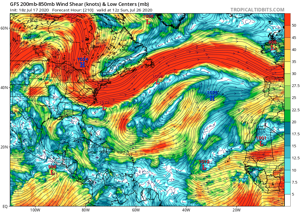
Big TUTT low in the SW Atlantic typical of this time of year. No way we are getting development of any MDR wave that heads towards the Bahamas if the GFS right:


0 likes
Re: 2020 Global Model Runs Discussion (Out thru day 16)
18z GEFS is waking up. More active than previous runs.


8 likes
The following post is NOT an official forecast and should not be used as such. It is just the opinion of the poster and may or may not be backed by sound meteorological data. It is NOT endorsed by any professional institution including storm2k.org For Official Information please refer to the NHC and NWS products.
- MississippiWx
- S2K Supporter

- Posts: 1720
- Joined: Sat Aug 14, 2010 1:44 pm
- Location: Hattiesburg, Mississippi
Re: 2020 Global Model Runs Discussion (Out thru day 16)
gatorcane wrote:Big TUTT low in the SW Atlantic typical of this time of year. No way we are getting development of any MDR wave that heads towards the Bahamas if the GFS right:
https://i.postimg.cc/tJ0J9ZvP/gfs-shear-atl-36.png
Sometimes the TUTT helps to ignite convection and sharpen the wave axis. Once on the other side of the TUTT, it could find a favorable scenario. Shear forecasts at 200 hours are basically zero skill, however.
7 likes
This post is not an official forecast and should not be used as such. It is just the opinion of MississippiWx and may or may not be backed by sound meteorological data. It is not endorsed by any professional institution including storm2k.org. For Official Information please refer to the NHC and NWS products.
- toad strangler
- S2K Supporter

- Posts: 4546
- Joined: Sun Jul 28, 2013 3:09 pm
- Location: Earth
- Contact:
Re: 2020 Global Model Runs Discussion (Out thru day 16)
MississippiWx wrote:gatorcane wrote:Big TUTT low in the SW Atlantic typical of this time of year. No way we are getting development of any MDR wave that heads towards the Bahamas if the GFS right:
https://i.postimg.cc/tJ0J9ZvP/gfs-shear-atl-36.png
Sometimes the TUTT helps to ignite convection and sharpen the wave axis. Once on the other side of the TUTT, it could find a favorable scenario. Shear forecasts at 200 hours are basically zero skill, however.
Yep, a TUTT gave Irma a turbo blast as she passed to the SW of said TUTT
1 likes
My Weather Station
https://www.wunderground.com/dashboard/pws/KFLPORTS603
https://www.wunderground.com/dashboard/pws/KFLPORTS603
Re: 2020 Global Model Runs Discussion (Out thru day 16)
gatorcane wrote:Big TUTT low in the SW Atlantic typical of this time of year. No way we are getting development of any MDR wave that heads towards the Bahamas if the GFS right:
https://i.postimg.cc/tJ0J9ZvP/gfs-shear-atl-36.png
The Euro has been persistently showing UL anticyclonic flow on top of the AEW that the GEFS and Euro have been showing developing late next week as it tracks westward. I wouldn't believe that GFS shear forecast past its 96-120 hr forecast, it likes to exaggerate shear by a good 5-10 knots.

1 likes
- TheProfessor
- Professional-Met

- Posts: 3506
- Age: 29
- Joined: Tue Dec 03, 2013 10:56 am
- Location: Wichita, Kansas
Re: 2020 Global Model Runs Discussion (Out thru day 16)
Canadian tonight is weaker and further south with the MDR storm it develops. It will be interesting to see how the storm interacts in the Caribbean this run or if it simply goes poof.
Edit: It went poof.
Edit: It went poof.
1 likes
An alumnus of The Ohio State University.
Your local National Weather Service office is your best source for weather information.
Your local National Weather Service office is your best source for weather information.
Re: 2020 Global Model Runs Discussion (Out thru day 16)
CMC jumping on the wave train.
Wave that came off Africa on Thursday.
Genesis Monday in the ITCZ (10N, 33W).
Takes it to the Islands.


Wave that came off Africa on Thursday.
Genesis Monday in the ITCZ (10N, 33W).
Takes it to the Islands.


0 likes
Re: 2020 Global Model Runs Discussion (Out thru day 16)
Latest GFS pushes out the GOM genesis 12 hrs from yesterday's 00Z run


1 likes
-
Aric Dunn
- Category 5

- Posts: 21238
- Age: 43
- Joined: Sun Sep 19, 2004 9:58 pm
- Location: Ready for the Chase.
- Contact:
Re: 2020 Global Model Runs Discussion (Out thru day 16)
I must say this wave/area is looking mighty interesting today....
correlates to the GFS ensembles and CMC>.
The axis has started to lift as the ITCZ to east buckles ahead of the next wave. This may cause a kink in axis that eventually leads to the CMC/GFS solutions

correlates to the GFS ensembles and CMC>.
The axis has started to lift as the ITCZ to east buckles ahead of the next wave. This may cause a kink in axis that eventually leads to the CMC/GFS solutions

1 likes
Note: If I make a post that is brief. Please refer back to previous posts for the analysis or reasoning. I do not re-write/qoute what my initial post said each time.
If there is nothing before... then just ask
Space & Atmospheric Physicist, Embry-Riddle Aeronautical University,
I believe the sky is falling...
If there is nothing before... then just ask
Space & Atmospheric Physicist, Embry-Riddle Aeronautical University,
I believe the sky is falling...
Re: 2020 Global Model Runs Discussion (Out thru day 16)
GCANE wrote:CMC jumping on the wave train.
Wave that came off Africa on Thursday.
Genesis Monday in the ITCZ (10N, 33W).
Takes it to the Islands.
https://i.imgur.com/w2dNoYK.png
https://i.imgur.com/gOPQl8c.png
12Z CMC pushes it deeper into the Carib, just south of Hispaniola

1 likes
Who is online
Users browsing this forum: No registered users and 183 guests


