

Moderator: S2k Moderators


DorkyMcDorkface wrote:EPS support has dropped off for that next TW (not the 10/10) but it looks like there's some enthusiasm for another one behind it. That one will be exiting by the middle of the month, which if I am not mistaken is when things are expected to pick back up again. I'd watch for any more model support for this one.
https://i.ibb.co/0yCpPb2/wavenew.png
https://i.ibb.co/WKG78b7/wavenew2.png


Dean4Storms wrote:12z ECM EPS with zilch chance of TS Development in the entire Atl. Basin thru the 17th.

captainbarbossa19 wrote:Dean4Storms wrote:12z ECM EPS with zilch chance of TS Development in the entire Atl. Basin thru the 17th.
I think it's quite possible that cyclogenesis may occur with a system sooner than expected. We could very well only have a few days notice from the models. I do not believe that the Atlantic will stay quiet much longer. I think part of the problem is that current unfavorable conditions are in place and the models are having are difficult time determining when they will become more favorable. Today, I noticed that the sun angle has changed quite a bit at my location and the sky is beginning to look more like autumn. The peak is getting closer.

toad strangler wrote:captainbarbossa19 wrote:Dean4Storms wrote:12z ECM EPS with zilch chance of TS Development in the entire Atl. Basin thru the 17th.
I think it's quite possible that cyclogenesis may occur with a system sooner than expected. We could very well only have a few days notice from the models. I do not believe that the Atlantic will stay quiet much longer. I think part of the problem is that current unfavorable conditions are in place and the models are having are difficult time determining when they will become more favorable. Today, I noticed that the sun angle has changed quite a bit at my location and the sky is beginning to look more like autumn. The peak is getting closer.
Yep, we are just about at the foothills of the steep climb to peak season 35 days from now. GFS has been quiet since it lost that SW Caribbean ghost a few days ago and the Euro has been quiet as a church mouse. Enjoy ..

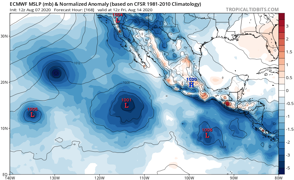
gatorcane wrote:The GFS is very reluctant to reduce the strong shear over the Caribbean and really a lot of the MDR for that matter. Also dry mid-level air is evident in the model fields. Euro is singing crickets. Now over in the EPAC though, the models are really lighting up. If you want to track something you will have plenty track in the EPAC. Atlantic continues to be as dead as it can be for August.
gatorcane wrote:The GFS is very reluctant to reduce the strong shear over the Caribbean and really a lot of the MDR for that matter. Also dry mid-level air is evident in the model fields. Euro is singing crickets. Now over in the EPAC though, the models are really lighting up. If you want to track something you will have plenty track in the EPAC. Atlantic continues to be as dead as it can be for August.


gatorcane wrote:The GFS is very reluctant to reduce the strong shear over the Caribbean and really a lot of the MDR for that matter. Also dry mid-level air is evident in the model fields. Euro is singing crickets. Now over in the EPAC though, the models are really lighting up. If you want to track something you will have plenty track in the EPAC. Atlantic continues to be as dead as it can be for August.
gatorcane wrote:The GFS is very reluctant to reduce the strong shear over the Caribbean and really a lot of the MDR for that matter. Also dry mid-level air is evident in the model fields. Euro is singing crickets. Now over in the EPAC though, the models are really lighting up. If you want to track something you will have plenty track in the EPAC. Atlantic continues to be as dead as it can be for August.

cycloneye wrote:gatorcane wrote:The GFS is very reluctant to reduce the strong shear over the Caribbean and really a lot of the MDR for that matter. Also dry mid-level air is evident in the model fields. Euro is singing crickets. Now over in the EPAC though, the models are really lighting up. If you want to track something you will have plenty track in the EPAC. Atlantic continues to be as dead as it can be for August.
Here is the next two week forecast from CSU that says it all.
https://tropical.colostate.edu/Forecast/2020-0805.pdf


Hurricaneman wrote:With the rising motion in the Atlantic after day 7 it surprises me that the model develops nothing on the GFS, might be a case that the model is not correctly resolving rising motion to what’s out there on the model, have to think the GFS is out to lunch and may not show anything until formation is nearly happening


cycloneye wrote:Finnally, GFS has something developing on MDR after the 20th.
https://i.imgur.com/Hp3hnSO.gif
Users browsing this forum: No registered users and 409 guests