2020 Global Model Runs Discussion (Out thru day 16)

This is the general tropical discussion area. Anyone can take their shot at predicting a storms path.

Moderator: S2k Moderators

Forum rules

The posts in this forum are NOT official forecasts and should not be used as such. They are just the opinion of the poster and may or may not be backed by sound meteorological data. They are NOT endorsed by any professional institution or STORM2K. For official information, please refer to products from the National Hurricane Center and National Weather Service.

Help Support Storm2K
Message
Author
User avatar
cycloneye
Admin
Admin
Posts: 145299
Age: 68
Joined: Thu Oct 10, 2002 10:54 am
Location: San Juan, Puerto Rico

Re: 2020 Global Model Runs Discussion (Out thru day 16)

#1141 Postby cycloneye » Sat Aug 08, 2020 7:01 am

SFLcane wrote:
cycloneye wrote:Finnally, GFS has something developing on MDR after the 20th.

https://i.imgur.com/Hp3hnSO.gif


Hi Luis, It's too far out to trust but that would be around the time you might expect to see the flip switch.


That is why I enfatized on the 20th.
5 likes   
Visit the Caribbean-Central America Weather Thread where you can find at first post web cams,radars
and observations from Caribbean basin members Click Here

User avatar
cycloneye
Admin
Admin
Posts: 145299
Age: 68
Joined: Thu Oct 10, 2002 10:54 am
Location: San Juan, Puerto Rico

Re: 2020 Global Model Runs Discussion (Out thru day 16)

#1142 Postby cycloneye » Sat Aug 08, 2020 7:59 am

2 likes   
Visit the Caribbean-Central America Weather Thread where you can find at first post web cams,radars
and observations from Caribbean basin members Click Here

User avatar
AnnularCane
S2K Supporter
S2K Supporter
Posts: 2862
Joined: Thu Jun 08, 2006 9:18 am
Location: Wytheville, VA

Re: 2020 Global Model Runs Discussion (Out thru day 16)

#1143 Postby AnnularCane » Sat Aug 08, 2020 8:45 am

:uarrow: I wonder why he only takes the active period to 9/18.
2 likes   

TheStormExpert

Re: 2020 Global Model Runs Discussion (Out thru day 16)

#1144 Postby TheStormExpert » Sat Aug 08, 2020 8:55 am

Well this is a start! :eek:
0 likes   

User avatar
toad strangler
S2K Supporter
S2K Supporter
Posts: 4543
Joined: Sun Jul 28, 2013 3:09 pm
Location: Earth
Contact:

Re: 2020 Global Model Runs Discussion (Out thru day 16)

#1145 Postby toad strangler » Sat Aug 08, 2020 9:19 am

AnnularCane wrote::uarrow: I wonder why he only takes the active period to 9/18.


October will be favorable as well. I'm assuming he's talking about a single long duration outbreak there. Probably a good break afterwards but by all means DO NOT count October out this year above all given indicators.
3 likes   

User avatar
DorkyMcDorkface
Category 3
Category 3
Posts: 888
Age: 27
Joined: Mon Sep 30, 2019 1:32 pm
Location: Mid-Atlantic

Re: 2020 Global Model Runs Discussion (Out thru day 16)

#1146 Postby DorkyMcDorkface » Sat Aug 08, 2020 9:59 am

The two waves that showed up towards the end of the 12z Euro run from yesterday were there again at 00z. The one in the CATL looks better defined, too. Once again this is roughly the time frame in which things will start to ignite once again so definitely continue to watch closely for model trends.

Image
2 likes   
Please note the thougths expressed by this account are solely those of the user and are from a hobbyist perspective. For more comprehensive analysis, consult an actual professional meteorologist or meteorology agency.


Floyd 1999 | Isabel 2003 | Hanna 2008 | Irene 2011 | Sandy 2012 | Isaias 2020

User avatar
gatorcane
S2K Supporter
S2K Supporter
Posts: 23691
Age: 47
Joined: Sun Mar 13, 2005 3:54 pm
Location: Boca Raton, FL

Re: 2020 Global Model Runs Discussion (Out thru day 16)

#1147 Postby gatorcane » Sat Aug 08, 2020 11:45 am

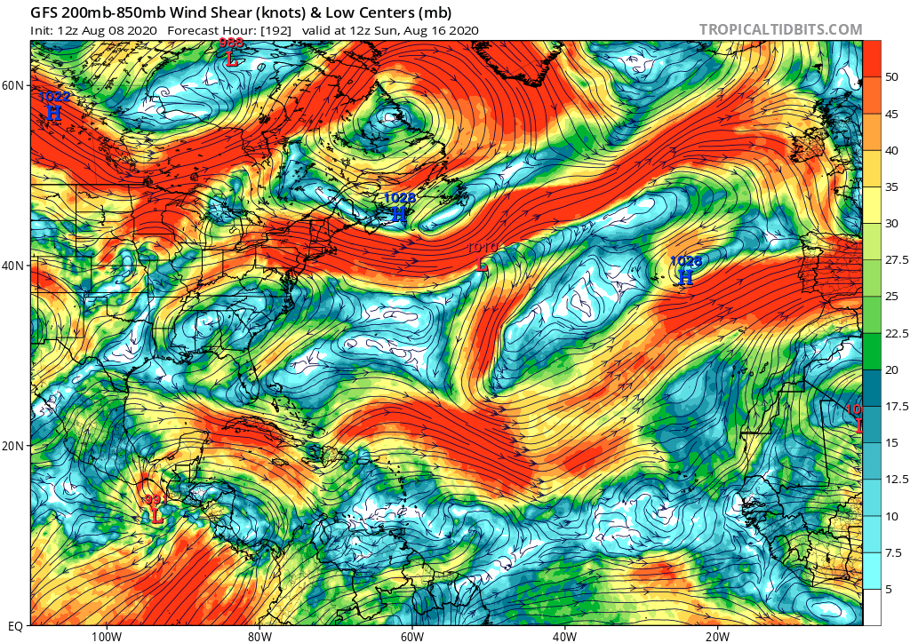
The GFS is showing an abundance of shear across the Western Caribbean and extending eastward in the MDR due to EPAC activity. You can see the 991MB storm in the EPAC which later goes on to becoming potentially a major hurricane.

Image
0 likes   

User avatar
SFLcane
S2K Supporter
S2K Supporter
Posts: 10163
Age: 47
Joined: Sat Jun 05, 2010 1:44 pm
Location: Lake Worth Florida

Re: 2020 Global Model Runs Discussion (Out thru day 16)

#1148 Postby SFLcane » Sat Aug 08, 2020 12:06 pm

gatorcane wrote:The GFS is showing an abundance of shear across the Western Caribbean and extending eastward in the MDR due to EPAC activity. You can see the 991MB storm in the EPAC which later goes on to becoming potentially a major hurricane.

https://i.postimg.cc/sgvfm4PK/gfs-shear-atl-33.png


The Atlantic will not take off as long as the EPAC is going strong thats pretty much guaranteed. Honestly could be almost the end of August before we're totally favorable.
0 likes   

User avatar
Hammy
Category 5
Category 5
Posts: 5849
Age: 41
Joined: Fri May 25, 2012 5:25 pm
Contact:

Re: 2020 Global Model Runs Discussion (Out thru day 16)

#1149 Postby Hammy » Sat Aug 08, 2020 12:20 pm

AnnularCane wrote::uarrow: I wonder why he only takes the active period to 9/18.


A lot of seasons that have active Septembers have a lull, or at least a slowing down, somewhere near the end of the month, more than likely resulting from Kelvin waves and MJO cycle.
5 likes   
The above post is not official and should not be used as such. It is the opinion of the poster and may or may not be backed by sound meteorological data. It is not endorsed by any professional institution or storm2k.org. For official information, please refer to the NHC and NWS products.

User avatar
toad strangler
S2K Supporter
S2K Supporter
Posts: 4543
Joined: Sun Jul 28, 2013 3:09 pm
Location: Earth
Contact:

Re: 2020 Global Model Runs Discussion (Out thru day 16)

#1150 Postby toad strangler » Sat Aug 08, 2020 12:22 pm

SFLcane wrote:
gatorcane wrote:The GFS is showing an abundance of shear across the Western Caribbean and extending eastward in the MDR due to EPAC activity. You can see the 991MB storm in the EPAC which later goes on to becoming potentially a major hurricane.

https://i.postimg.cc/sgvfm4PK/gfs-shear-atl-33.png


The Atlantic will not take off as long as the EPAC is going strong thats pretty much guaranteed. Honestly could be almost the end of August before we're totally favorable.


Sure, if you take GFS post 7 days as gospel.
3 likes   

User avatar
MississippiWx
S2K Supporter
S2K Supporter
Posts: 1699
Joined: Sat Aug 14, 2010 1:44 pm
Location: Hattiesburg, Mississippi

Re: 2020 Global Model Runs Discussion (Out thru day 16)

#1151 Postby MississippiWx » Sat Aug 08, 2020 12:27 pm

The base state in the Eastern Pacific does not favor hyperactivity. There might be a week or two of heightened activity there, but we have seen time and again this season where EPac modeled tropical cyclones fail to develop. Even when the Atlantic wouldn’t typically favor development, we’ve had development. I would be very wary of model runs showing hyperactivity in the EPac during a strengthening La Niña.
7 likes   
This post is not an official forecast and should not be used as such. It is just the opinion of MississippiWx and may or may not be backed by sound meteorological data. It is not endorsed by any professional institution including storm2k.org. For Official Information please refer to the NHC and NWS products.

User avatar
aspen
Category 5
Category 5
Posts: 8818
Joined: Sat Oct 12, 2019 7:10 pm
Location: Connecticut, USA

Re: 2020 Global Model Runs Discussion (Out thru day 16)

#1152 Postby aspen » Sat Aug 08, 2020 12:31 pm

toad strangler wrote:
SFLcane wrote:
gatorcane wrote:The GFS is showing an abundance of shear across the Western Caribbean and extending eastward in the MDR due to EPAC activity. You can see the 991MB storm in the EPAC which later goes on to becoming potentially a major hurricane.

https://i.postimg.cc/sgvfm4PK/gfs-shear-atl-33.png


The Atlantic will not take off as long as the EPAC is going strong thats pretty much guaranteed. Honestly could be almost the end of August before we're totally favorable.


Sure, if you take GFS post 7 days as gospel.

It’s highly unlikely those post day 7 storms will verify, which means it’s also highly unlikely that EPac produced shear will be present. The GFS has been busting over and over again with the EPac, so even if we do have a little rise in activity next week, chances are slim that multiple storms and at least one hurricane will be present.
2 likes   
Irene '11 Sandy '12 Hermine '16 5/15/2018 Derecho Fay '20 Isaias '20 Elsa '21 Henri '21 Ida '21

I am only a meteorology enthusiast who knows a decent amount about tropical cyclones. Look to the professional mets, the NHC, or your local weather office for the best information.

User avatar
gfsperpendicular
Category 1
Category 1
Posts: 383
Age: 21
Joined: Mon Jun 19, 2017 3:04 pm
Location: Northern Virginia

Re: 2020 Global Model Runs Discussion (Out thru day 16)

#1153 Postby gfsperpendicular » Sat Aug 08, 2020 1:00 pm

gatorcane wrote:The GFS is showing an abundance of shear across the Western Caribbean and extending eastward in the MDR due to EPAC activity. You can see the 991MB storm in the EPAC which later goes on to becoming potentially a major hurricane.

https://i.postimg.cc/sgvfm4PK/gfs-shear-atl-33.png


The GFS has been showing the Atlantic, especially the Caribbean and MDR, overloaded with shear for over a month now and that simply has not verified so far. In other words, I'll believe it when I see it.
7 likes   
I'm not sleeping, I'm waiting for the 0900 UTC advisory!

#1 CMC stan

User avatar
EquusStorm
Category 5
Category 5
Posts: 1649
Age: 34
Joined: Thu Nov 07, 2013 1:04 pm
Location: Jasper, AL
Contact:

Re: 2020 Global Model Runs Discussion (Out thru day 16)

#1154 Postby EquusStorm » Sat Aug 08, 2020 1:07 pm

The problem here is assuming the mid range GFS has a handle on the tropics at all this year

I thought we learned that in July
6 likes   
Colors of lost purpose on the canvas of irrelevance

Not a meteorologist, in fact more of an idiot than anything. You should probably check with the NHC or a local NWS office for official information.

User avatar
SFLcane
S2K Supporter
S2K Supporter
Posts: 10163
Age: 47
Joined: Sat Jun 05, 2010 1:44 pm
Location: Lake Worth Florida

Re: 2020 Global Model Runs Discussion (Out thru day 16)

#1155 Postby SFLcane » Sat Aug 08, 2020 1:33 pm

toad strangler wrote:
SFLcane wrote:
gatorcane wrote:The GFS is showing an abundance of shear across the Western Caribbean and extending eastward in the MDR due to EPAC activity. You can see the 991MB storm in the EPAC which later goes on to becoming potentially a major hurricane.

https://i.postimg.cc/sgvfm4PK/gfs-shear-atl-33.png


The Atlantic will not take off as long as the EPAC is going strong thats pretty much guaranteed. Honestly could be almost the end of August before we're totally favorable.


Sure, if you take GFS post 7 days as gospel.


As long as there's large scale convection in the E-pac it will sheer the Atlantic.
0 likes   

User avatar
CyclonicFury
Category 5
Category 5
Posts: 2025
Age: 26
Joined: Sun Jul 02, 2017 12:32 pm
Location: NC
Contact:

Re: 2020 Global Model Runs Discussion (Out thru day 16)

#1156 Postby CyclonicFury » Sat Aug 08, 2020 1:42 pm

SFLcane wrote:
toad strangler wrote:
SFLcane wrote:

The Atlantic will not take off as long as the EPAC is going strong thats pretty much guaranteed. Honestly could be almost the end of August before we're totally favorable.

Sure, if you take GFS post 7 days as gospel.


As long as there's large scale convection in the E-pac it will sheer the Atlantic.

While this is often true, it is actually possible to have the EPAC and Atlantic active at the same time. August 2016, September 2017, September-October 2018, and September 2019 are examples of this. There were a few EPAC systems active when Maria formed.
Last edited by CyclonicFury on Sat Aug 08, 2020 1:43 pm, edited 1 time in total.
4 likes   
NCSU B.S. in Meteorology Class of 2021. Tropical weather blogger at http://www.cyclonicfury.com. My forecasts and thoughts are NOT official, for official forecasts please consult the National Hurricane Center.

TheStormExpert

Re: 2020 Global Model Runs Discussion (Out thru day 16)

#1157 Postby TheStormExpert » Sat Aug 08, 2020 1:43 pm

SFLcane wrote:
toad strangler wrote:
SFLcane wrote:

The Atlantic will not take off as long as the EPAC is going strong thats pretty much guaranteed. Honestly could be almost the end of August before we're totally favorable.


Sure, if you take GFS post 7 days as gospel.


As long as there's large scale convection in the E-pac it will sheer the Atlantic.

You can still get storms in the Tropical and Subtropical Atlantic even with an active East Pacific, especially now that we’re in August. The Gulf of Mexico and Caribbean will still have some shear with an active East Pacific assuming it lives up to the expectations.
1 likes   

TheStormExpert

Re: 2020 Global Model Runs Discussion (Out thru day 16)

#1158 Postby TheStormExpert » Sat Aug 08, 2020 1:45 pm

MississippiWx wrote:The base state in the Eastern Pacific does not favor hyperactivity. There might be a week or two of heightened activity there, but we have seen time and again this season where EPac modeled tropical cyclones fail to develop. Even when the Atlantic wouldn’t typically favor development, we’ve had development. I would be very wary of model runs showing hyperactivity in the EPac during a strengthening La Niña.

Story of the East Pacific season thus far! Despite Douglas the basin has significantly underperformed.
0 likes   

User avatar
EquusStorm
Category 5
Category 5
Posts: 1649
Age: 34
Joined: Thu Nov 07, 2013 1:04 pm
Location: Jasper, AL
Contact:

Re: 2020 Global Model Runs Discussion (Out thru day 16)

#1159 Postby EquusStorm » Sat Aug 08, 2020 1:46 pm

September last year saw three systems active simultaneously in both basins, with two hurricanes in the Atlantic, so despite the rule of thumb dual basin activity is certainly possible; that said it's getting off track from models probably
2 likes   
Colors of lost purpose on the canvas of irrelevance

Not a meteorologist, in fact more of an idiot than anything. You should probably check with the NHC or a local NWS office for official information.

Monsoonjr99
Tropical Storm
Tropical Storm
Posts: 210
Age: 26
Joined: Fri Sep 21, 2018 11:22 pm
Location: Inland Empire, SoCal

Re: 2020 Global Model Runs Discussion (Out thru day 16)

#1160 Postby Monsoonjr99 » Sat Aug 08, 2020 3:08 pm

It seems the latest model upgrades have been calibrated based on the persistent warm neutral/El Nino state that had been entrenched since 2014 (apart from two brief La Nina events in 2016 and 2017). With 2020 swinging to La Nina, the models may be way off on the base state in the EPac and Atlantic.
1 likes   
The posts in this forum are NOT official forecasts and should not be used as such. They are just the opinion of the poster and may or may not be backed by sound meteorological data. They are NOT endorsed by any professional institution or STORM2K. For official information, please refer to products from the NHC and NWS.

Some Californian who codes things and tracks weather.

Kay '22, Hilary '23


Return to “Talkin' Tropics”

Who is online

Users browsing this forum: No registered users and 18 guests