ATL: JOSEPHINE - Remnants - Discussion
Moderator: S2k Moderators
-
Aric Dunn
- Category 5

- Posts: 21238
- Age: 43
- Joined: Sun Sep 19, 2004 9:58 pm
- Location: Ready for the Chase.
- Contact:
Re: ATL: ELEVEN - Tropical Depression - Discussion
looking at the last 30 min of visible and into IR.. looks like the center was rapidly pulled to the WNW it is likely now just to the left of the towers. makes things very interesting if that indeed has taken place.
0 likes
Note: If I make a post that is brief. Please refer back to previous posts for the analysis or reasoning. I do not re-write/qoute what my initial post said each time.
If there is nothing before... then just ask
Space & Atmospheric Physicist, Embry-Riddle Aeronautical University,
I believe the sky is falling...
If there is nothing before... then just ask
Space & Atmospheric Physicist, Embry-Riddle Aeronautical University,
I believe the sky is falling...
-
Blown Away

- S2K Supporter

- Posts: 10253
- Joined: Wed May 26, 2004 6:17 am
Re: ATL: ELEVEN - Tropical Depression - Discussion
Aric Dunn wrote:looking at the last 30 min of visible and into IR.. looks like the center was rapidly pulled to the WNW it is likely now just to the left of the towers. makes things very interesting if that indeed has taken place.


11 likes
Hurricane Eye Experience: David 79, Irene 99, Frances 04, Jeanne 04, Wilma 05… Hurricane Brush Experience: Andrew 92, Erin 95, Floyd 99, Matthew 16, Irma 17, Ian 22, Nicole 22…
-
Kingarabian

- S2K Supporter
- Posts: 16342
- Joined: Sat Aug 08, 2009 3:06 am
- Location: Honolulu, Hawaii
Re: ATL: ELEVEN - Tropical Depression - Discussion
Probably a TS at this point. The outflow to the N/NE screams that to me.
8 likes
RIP Kobe Bryant
-
cainjamin

- Tropical Storm

- Posts: 173
- Age: 34
- Joined: Mon Apr 17, 2017 1:38 pm
- Location: Nova Scotia, Canada
Re: ATL: ELEVEN - Tropical Depression - Discussion
Convection is still more busrt-like than banding, but still likely very close to TS strength.
0 likes
Noel '07, Kyle '08, Earl '10, Arthur '14, Dorian '19, Teddy '20, Lee '23
Re: ATL: ELEVEN - Tropical Depression - Discussion
gatorcane wrote:Not a surprise it is organizing some. Models said it would over the next couple of days. But the wall of shear awaits...
The question is will it be organizing some or will it unexpectedly overachieve substantially. Looking at Gcane's posts and at how models did with other storms this year, I would argue that "this is possible" would be an understatement.
But yes then the shear awaits, altough some changes in that forecast wouldn't surprise me.
0 likes
-
ConvergenceZone
.gif)
- Category 5
- Posts: 5241
- Joined: Fri Jul 29, 2005 1:40 am
- Location: Northern California
Re: ATL: ELEVEN - Tropical Depression - Discussion
Visioen wrote:gatorcane wrote:Not a surprise it is organizing some. Models said it would over the next couple of days. But the wall of shear awaits...
The question is will it be organizing some or will it unexpectedly overachieve substantially. Looking at Gcane's posts and at how models did with other storms this year, I would argue that "this is possible" would be an understatement.
But yes then the shear awaits, altough some changes in that forecast wouldn't surprise me.
I never look at models when it comes to strength, as they are absolutely horrible, as this year has clearly demonstrated
7 likes
-
wxman57

- Moderator-Pro Met

- Posts: 23170
- Age: 68
- Joined: Sat Jun 21, 2003 8:06 pm
- Location: Houston, TX (southwest)
Re: ATL: ELEVEN - Tropical Depression - Discussion
Still looks more like a tropical wave with a bit of convection (and an associated vortex) on the NW side. We see this kind of wave quite often in August and September, usually closer to Africa (and usually not named). The convection needs to break away from the wave for it to have much of a chance of significant strengthening. Such systems often produce 35kt winds, I'm sure. The NHC will likely call it Josephine tomorrow (or tonight, if Stewart is working), and it'll weaken in a day or two. Another short-lived weak TS, which will make 5 out of 10 so far. The only impacts across the NE Caribbean will be decreased easterly trade winds this weekend.

4 likes
-
wxman57
- Moderator-Pro Met
- Posts: 23170
- Age: 68
- Joined: Sat Jun 21, 2003 8:06 pm
- Location: Houston, TX (southwest)
Re: ATL: ELEVEN - Tropical Depression - Discussion
ConvergenceZone wrote:Visioen wrote:gatorcane wrote:Not a surprise it is organizing some. Models said it would over the next couple of days. But the wall of shear awaits...
The question is will it be organizing some or will it unexpectedly overachieve substantially. Looking at Gcane's posts and at how models did with other storms this year, I would argue that "this is possible" would be an understatement.
But yes then the shear awaits, although some changes in that forecast wouldn't surprise me.
I never look at models when it comes to strength, as they are absolutely horrible, as this year has clearly demonstrated
Like when the models predicted Gonzalo to enter the Caribbean as a dissipating depression and the forecast was for a hurricane? Oh, wait, it DID dissipate as it entered the Caribbean, just as the models predicted. We had predicted it to dissipate in the eastern Caribbean while the official forecast was for it to be a hurricane in the east Caribbean. Global models got it right, while the "tropical model", HWRF had it nearly as a Cat 3 in the eastern Caribbean. NHC split the difference, guaranteeing a wrong forecast. Don't get me wrong, I know the NHC forecasters and have great respect for them. They made a decision that it would be safer to over-warn the residents of the eastern Caribbean islands rather than to tell them not to worry, as it would dissipate. They have a tough job.
Sometimes the models do have a clue (well, except HMON, NOGAPS, and the NAM). The challenge is to identify when. As for TD Eleven, I don't have to look at the models to see that it is struggling in an unfavorable environment. The models just confirm that.
9 likes
-
Aric Dunn
- Category 5
- Posts: 21238
- Age: 43
- Joined: Sun Sep 19, 2004 9:58 pm
- Location: Ready for the Chase.
- Contact:
Re: ATL: ELEVEN - Tropical Depression - Discussion
Scat from 4 hours ago.. defintely not a open wave.. lol

7 likes
Note: If I make a post that is brief. Please refer back to previous posts for the analysis or reasoning. I do not re-write/qoute what my initial post said each time.
If there is nothing before... then just ask
Space & Atmospheric Physicist, Embry-Riddle Aeronautical University,
I believe the sky is falling...
If there is nothing before... then just ask
Space & Atmospheric Physicist, Embry-Riddle Aeronautical University,
I believe the sky is falling...
-
amawea

- S2K Supporter
- Posts: 385
- Age: 74
- Joined: Mon Aug 09, 2004 3:36 pm
- Location: Horseshoe Bend, Ar. but from Baytown, Tx
Re: ATL: ELEVEN - Tropical Depression - Discussion
wxman57, I have come to have total confidence in your forecasting abilities whether it be rain, sleet or snow or the tropical winds that blow. Albeit, sometimes i wish you were wrong when it comes to the no snow forecast. Your a great meteorologist. Thanks for your services.
1 likes
-
ozonepete
- Professional-Met

- Posts: 4743
- Joined: Mon Sep 07, 2009 3:23 pm
- Location: From Ozone Park, NYC / Now in Brooklyn, NY
Re: ATL: ELEVEN - Tropical Depression - Discussion
This much is easy: If it were an open wave NHC would not have named it a TD nor would they still be calling it one. The scatterometer data Aric posted verifies that it has a closed circulation and plenty of organized convection.
7 likes
-
wxman57
- Moderator-Pro Met
- Posts: 23170
- Age: 68
- Joined: Sat Jun 21, 2003 8:06 pm
- Location: Houston, TX (southwest)
Re: ATL: ELEVEN - Tropical Depression - Discussion
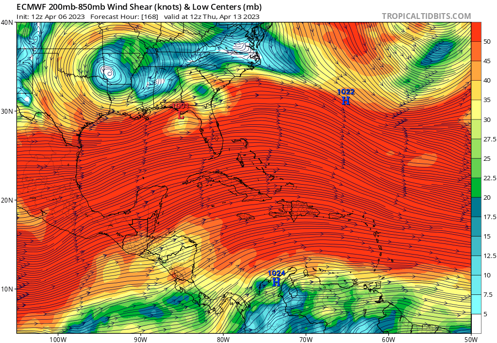
ECMWF 200-850mb shear forecast for Friday says "come on, TD Eleven, look what's waiting for you as you approach the Caribbean!"
0 likes
-
CyclonicFury

- Category 5
- Posts: 2032
- Age: 27
- Joined: Sun Jul 02, 2017 12:32 pm
- Location: NC
- Contact:
Re: ATL: ELEVEN - Tropical Depression - Discussion
TXNT21 KNES 122358
TCSNTL
A. 11L (NONAME)
B. 12/2330Z
C. 12.0N
D. 46.0W
E. FIVE/GOES-E
F. T1.5/2.5
G. IR/EIR/SWIR
H. REMARKS...A LLCC CHARACTERIZED BY CIRCULARLY DEFINED CLOUD LINES
THAT IS GREATER THAN 1.25 DEGREES REMOVED FROM A LARGE AREA OF ACTIVE
CONVECTION RESULTS IN A DT OF 1.5. THE MET IS 2.0 BASED ON A SIMILAR
APPARENT INTENSITY COMPARED TO 24 HOURS AGO AND THE PT IS 1.5. THE FT
IS BASED ON THE DT.
I. ADDL POSITIONS
NIL
...HOSLEY
Interestingly SAB fixed the center much farther south than the NHC position, resulting in only a T1.5.
3 likes
NCSU B.S. in Meteorology Class of 2021. Tropical weather blogger at http://www.cyclonicfury.com. My forecasts and thoughts are NOT official, for official forecasts please consult the National Hurricane Center.
-
wxman57
- Moderator-Pro Met
- Posts: 23170
- Age: 68
- Joined: Sat Jun 21, 2003 8:06 pm
- Location: Houston, TX (southwest)
Re: ATL: ELEVEN - Tropical Depression - Discussion
ozonepete wrote:This much is easy: If it were an open wave NHC would not have named it a TD nor would they still be calling it one. The scatterometer data Aric posted verifies that it has a closed circulation and plenty of organized convection.
It clearly has a small vortex, worthy of being called a TD, I suppose - but it has the appearance of a wave when you zoom out and look at the big picture. My point was that we often see such systems closer to Africa that are ignored.
2 likes
-
ozonepete
- Professional-Met
- Posts: 4743
- Joined: Mon Sep 07, 2009 3:23 pm
- Location: From Ozone Park, NYC / Now in Brooklyn, NY
Re: ATL: ELEVEN - Tropical Depression - Discussion
wxman57 wrote:ozonepete wrote:This much is easy: If it were an open wave NHC would not have named it a TD nor would they still be calling it one. The scatterometer data Aric posted verifies that it has a closed circulation and plenty of organized convection.
It clearly has a small vortex, worthy of being called a TD, I suppose - but it has the appearance of a wave when you zoom out and look at the big picture. My point was that we often see such systems closer to Africa that are ignored.
Well then thank goodness for scatterometer data!
3 likes
-
gatorcane

- S2K Supporter
- Posts: 23708
- Age: 48
- Joined: Sun Mar 13, 2005 3:54 pm
- Location: Boca Raton, FL
Re: ATL: ELEVEN - Tropical Depression - Discussion
wxman57 wrote:ECMWF 200-850mb shear forecast for Friday says "come on, TD Eleven, look what's waiting for you as you approach the Caribbean!"
http://wxman57.com/images/ECShear.png
Ouch that is some ripping shear! May not be anything left for it to regenerate as it recurves over the open Atlantic. Still a chance though.
Last edited by gatorcane on Wed Aug 12, 2020 7:32 pm, edited 1 time in total.
0 likes
-
Aric Dunn
- Category 5
- Posts: 21238
- Age: 43
- Joined: Sun Sep 19, 2004 9:58 pm
- Location: Ready for the Chase.
- Contact:
Re: ATL: ELEVEN - Tropical Depression - Discussion
ozonepete wrote:wxman57 wrote:ozonepete wrote:This much is easy: If it were an open wave NHC would not have named it a TD nor would they still be calling it one. The scatterometer data Aric posted verifies that it has a closed circulation and plenty of organized convection.
It clearly has a small vortex, worthy of being called a TD, I suppose - but it has the appearance of a wave when you zoom out and look at the big picture. My point was that we often see such systems closer to Africa that are ignored.
Well then thank goodness for scatterometer data!
I would also say it is a tad too large to be "small" vortex.

0 likes
Note: If I make a post that is brief. Please refer back to previous posts for the analysis or reasoning. I do not re-write/qoute what my initial post said each time.
If there is nothing before... then just ask
Space & Atmospheric Physicist, Embry-Riddle Aeronautical University,
I believe the sky is falling...
If there is nothing before... then just ask
Space & Atmospheric Physicist, Embry-Riddle Aeronautical University,
I believe the sky is falling...
-
floridasun78
- Category 5
- Posts: 3755
- Joined: Sun May 17, 2009 10:16 pm
- Location: miami fl
Re: ATL: ELEVEN - Tropical Depression - Discussion
so going be tropical wave at 11pm? what wxman57 saying
0 likes
-
CyclonicFury
- Category 5
- Posts: 2032
- Age: 27
- Joined: Sun Jul 02, 2017 12:32 pm
- Location: NC
- Contact:
Re: ATL: ELEVEN - Tropical Depression - Discussion
floridasun78 wrote:so going be tropical wave at 11pm? what wxman57 saying
Definitely not, there is a well-defined vortex present.
Also, 00z best track keeps it as a TD. Looks like no Josephine tonight, unless ASCAT confirms TS winds exist.
AL, 11, 2020081300, , BEST, 0, 127N, 463W, 30, 1007, TD
1 likes
NCSU B.S. in Meteorology Class of 2021. Tropical weather blogger at http://www.cyclonicfury.com. My forecasts and thoughts are NOT official, for official forecasts please consult the National Hurricane Center.
-
Aric Dunn
- Category 5
- Posts: 21238
- Age: 43
- Joined: Sun Sep 19, 2004 9:58 pm
- Location: Ready for the Chase.
- Contact:
Re: ATL: ELEVEN - Tropical Depression - Discussion
SCAT SAT ( which the NHC used recently) is showing a bunch of 35kt winds and a few 40 kt winds..
may end up being Josephine at 11pm .. right on the NHC schedule.

may end up being Josephine at 11pm .. right on the NHC schedule.
0 likes
Note: If I make a post that is brief. Please refer back to previous posts for the analysis or reasoning. I do not re-write/qoute what my initial post said each time.
If there is nothing before... then just ask
Space & Atmospheric Physicist, Embry-Riddle Aeronautical University,
I believe the sky is falling...
If there is nothing before... then just ask
Space & Atmospheric Physicist, Embry-Riddle Aeronautical University,
I believe the sky is falling...
Who is online
Users browsing this forum: No registered users and 14 guests