ATL: JOSEPHINE - Remnants - Discussion

Moderator: S2k Moderators

Message
Author
User avatar
1900hurricane
Category 5
Category 5
Posts: 6059
Age: 34
Joined: Fri Feb 06, 2015 12:04 pm
Location: Houston, TX
Contact:

Re: ATL: JOSEPHINE - Tropical Storm - Discussion

#601 Postby 1900hurricane » Fri Aug 14, 2020 11:41 pm

One interesting thing about Josephine's weak circulation south of the center is that it makes it a little more resistant to ingesting dry air to the west of the system. There really isn't much inflow to the south of the center, and most of it is coming from the east. For the dry air west of the system to penetrate into the circulation, it would have to hook all the way around to the east side and enter the inflow from that direction. You can kind of see this on microwave imagery, and the earlier ASCAT posted in this thread was also helpful in diagnosing storm inflow.

Image

However, the Catch 22 is that if Josephine tries to strengthen, it's going to improve the equatorialward inflow, and therefore more readily draw the dry air in. If it remains weak though, the TUTT will probably tear it apart. Josephine is kind of in a tough spot right now no matter what it does. I think the meteorologist aboard the latest recon flight may have said it best in this tweet.

 https://twitter.com/JeremyDeHart53d/status/1294392742135705603


7 likes   
Contract Meteorologist. TAMU & MSST. Fiercely authentic, one of a kind. We are all given free will, so choose a life meant to be lived. We are the Masters of our own Stories.
Opinions expressed are mine alone.

Follow me on Twitter at @1900hurricane : Read blogs at https://1900hurricane.wordpress.com/

Aric Dunn
Category 5
Category 5
Posts: 21238
Age: 42
Joined: Sun Sep 19, 2004 9:58 pm
Location: Ready for the Chase.
Contact:

Re: ATL: JOSEPHINE - Tropical Storm - Discussion

#602 Postby Aric Dunn » Fri Aug 14, 2020 11:49 pm

1900hurricane wrote:One interesting thing about Josephine's weak circulation south of the center is that it makes it a little more resistant to ingesting dry air to the west of the system. There really isn't much inflow to the south of the center, and most of it is coming from the east. For the dry air west of the system to penetrate into the circulation, it would have to hook all the way around to the east side and enter the inflow from that direction. You can kind of see this on microwave imagery, and the earlier ASCAT posted in this thread was also helpful in diagnosing storm inflow.

https://i.imgur.com/4FM6Z2y.jpg

However, the Catch 22 is that if Josephine tries to strengthen, it's going to improve the equatorialward inflow, and therefore more readily draw the dry air in. If it remains weak though, the TUTT will probably tear it apart. Josephine is kind of in a tough spot right now no matter what it does. I think the meteorologist aboard the latest recon flight may have said it best in this tweet.

https://twitter.com/JeremyDeHart53d/status/1294392742135705603


Dry air was a concern 3 days ago..

it has a large well-established pouch.. and any dry air has all but been eliminated. what is left is not enough to do anything but cause a hiccupp. Shear or not.

shear is the only thing that will weaken this/hold it in check.

Image
5 likes   
Note: If I make a post that is brief. Please refer back to previous posts for the analysis or reasoning. I do not re-write/qoute what my initial post said each time.
If there is nothing before... then just ask :)

Space & Atmospheric Physicist, Embry-Riddle Aeronautical University,
I believe the sky is falling...

User avatar
1900hurricane
Category 5
Category 5
Posts: 6059
Age: 34
Joined: Fri Feb 06, 2015 12:04 pm
Location: Houston, TX
Contact:

Re: ATL: JOSEPHINE - Tropical Storm - Discussion

#603 Postby 1900hurricane » Sat Aug 15, 2020 12:21 am

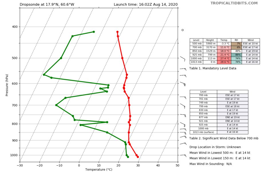
Still seems like a concern to me, especially with this drop to the W of Josephine with the earlier recon mission. That air is rotating around the circulation, but hasn't worked its way in as of yet because of the limited inflow. I've annotated the MetOp-B pass I posted above with both the dry air trajectory (solid arrows) and Josephine's main inflow (dashes). If Josephine is going to strengthen, it's going to draw in more air. A tropical cyclone is a Carnot Engine, and any engine is an air pump. With nearly 75% of the circulation surrounded by low PW air, that's not a good sign.

Image

Image
9 likes   
Contract Meteorologist. TAMU & MSST. Fiercely authentic, one of a kind. We are all given free will, so choose a life meant to be lived. We are the Masters of our own Stories.
Opinions expressed are mine alone.

Follow me on Twitter at @1900hurricane : Read blogs at https://1900hurricane.wordpress.com/

Chris90
Category 2
Category 2
Posts: 646
Age: 35
Joined: Thu Jun 01, 2017 9:36 pm

Re: ATL: JOSEPHINE - Tropical Storm - Discussion

#604 Postby Chris90 » Sat Aug 15, 2020 1:40 am

It would be interesting if Jo pulled an Irene ‘05 and got an injection of adrenaline in a few days as it heads north and reached hurricane status. I’m not making a forecast, as I’m not even going to attempt with this storm, but I’m watching with interest. I do think she might have some surprises up her sleeve.
0 likes   
Solar Aquarian
Lunar Cancerian
:uarrow: Sagittarian

User avatar
GCANE
S2K Supporter
S2K Supporter
Posts: 11496
Joined: Mon Oct 22, 2007 8:03 am

Re: ATL: JOSEPHINE - Tropical Storm - Discussion

#605 Postby GCANE » Sat Aug 15, 2020 4:34 am

ozonepete wrote:
GCANE wrote:This time tomorrow we could also see some convective debris from PR and DR entraining into Joe.


Hi G. Just wanted to ask if you knew that the nickname for Josephine is Jo, not Joe. Joe is for Joseph. I learned from my friend Josephine. :wink:


Thanks much Pete
2 likes   

User avatar
GCANE
S2K Supporter
S2K Supporter
Posts: 11496
Joined: Mon Oct 22, 2007 8:03 am

Re: ATL: JOSEPHINE - Tropical Storm - Discussion

#606 Postby GCANE » Sat Aug 15, 2020 4:58 am

Typical DMAX bursting underway.

Kyle formed a little faster and stronger than what I was thinking.
Looks like CONUS will likely be in the clear.
However there is another front forecast to stall along the east coast with another behind in the Midwest.
Convection plays a big role on modification of Rossby Waves.
Going to check into this in more detail.
0 likes   

User avatar
GCANE
S2K Supporter
S2K Supporter
Posts: 11496
Joined: Mon Oct 22, 2007 8:03 am

Re: ATL: JOSEPHINE - Tropical Storm - Discussion

#607 Postby GCANE » Sat Aug 15, 2020 5:05 am

Recon on the runway, transmitting telemetry.
0 likes   

User avatar
GCANE
S2K Supporter
S2K Supporter
Posts: 11496
Joined: Mon Oct 22, 2007 8:03 am

Re: ATL: JOSEPHINE - Tropical Storm - Discussion

#608 Postby GCANE » Sat Aug 15, 2020 5:24 am

That mid-level convective debris I mentioned last night may have done the trick.
She is deep in the shear now but deep convection is firing right on top of the CoC.
No sign of dry air entrainment.
Next big tell is if recon can find high rain rates.

Image

Image

Image

Image

Image
1 likes   

User avatar
GCANE
S2K Supporter
S2K Supporter
Posts: 11496
Joined: Mon Oct 22, 2007 8:03 am

Re: ATL: JOSEPHINE - Tropical Storm - Discussion

#609 Postby GCANE » Sat Aug 15, 2020 5:26 am

Final wind analysis of yesterday's recon run.

Image
0 likes   

User avatar
GCANE
S2K Supporter
S2K Supporter
Posts: 11496
Joined: Mon Oct 22, 2007 8:03 am

Re: ATL: JOSEPHINE - Tropical Storm - Discussion

#610 Postby GCANE » Sat Aug 15, 2020 5:27 am

Recon in the air
0 likes   

User avatar
GCANE
S2K Supporter
S2K Supporter
Posts: 11496
Joined: Mon Oct 22, 2007 8:03 am

Re: ATL: JOSEPHINE - Tropical Storm - Discussion

#611 Postby GCANE » Sat Aug 15, 2020 5:32 am

85 GHz Radar, 2 hrs ago.
Deep convection right on the money.
Amazing.

Image
0 likes   

xironman
S2K Supporter
S2K Supporter
Posts: 2522
Joined: Sun Jun 10, 2007 4:53 pm
Location: NoVA

Re: ATL: JOSEPHINE - Tropical Storm - Discussion

#612 Postby xironman » Sat Aug 15, 2020 5:41 am

Pretty light east winds at 500mb, I would have expected more mid level shear.
2 likes   

User avatar
GCANE
S2K Supporter
S2K Supporter
Posts: 11496
Joined: Mon Oct 22, 2007 8:03 am

Re: ATL: JOSEPHINE - Tropical Storm - Discussion

#613 Postby GCANE » Sat Aug 15, 2020 5:43 am

Already deep into the high CAPE air.
Would be great if they ran an high-altitude drop mission.

Image
0 likes   

User avatar
GCANE
S2K Supporter
S2K Supporter
Posts: 11496
Joined: Mon Oct 22, 2007 8:03 am

Re: ATL: JOSEPHINE - Tropical Storm - Discussion

#614 Postby GCANE » Sat Aug 15, 2020 5:46 am

xironman wrote:Pretty light east winds at 500mb, I would have expected more mid level shear.


Would be cool if they map at 700mb.
That is where GFS is showing an open wave.
0 likes   

xironman
S2K Supporter
S2K Supporter
Posts: 2522
Joined: Sun Jun 10, 2007 4:53 pm
Location: NoVA

Re: ATL: JOSEPHINE - Tropical Storm - Discussion

#615 Postby xironman » Sat Aug 15, 2020 5:47 am

I wonder why it is going to take such a hard right

Image
1 likes   

User avatar
GCANE
S2K Supporter
S2K Supporter
Posts: 11496
Joined: Mon Oct 22, 2007 8:03 am

Re: ATL: JOSEPHINE - Tropical Storm - Discussion

#616 Postby GCANE » Sat Aug 15, 2020 5:54 am

355K PV ring closed off on the north, east, and west.
A little streamer is coming down ahead of Jo.
That could be a problem.

Image
0 likes   

xironman
S2K Supporter
S2K Supporter
Posts: 2522
Joined: Sun Jun 10, 2007 4:53 pm
Location: NoVA

Re: ATL: JOSEPHINE - Tropical Storm - Discussion

#617 Postby xironman » Sat Aug 15, 2020 6:16 am

All the SFMRs are coming back flagged, instrument problem?
0 likes   

User avatar
GCANE
S2K Supporter
S2K Supporter
Posts: 11496
Joined: Mon Oct 22, 2007 8:03 am

Re: ATL: JOSEPHINE - Tropical Storm - Discussion

#618 Postby GCANE » Sat Aug 15, 2020 6:19 am

Drop in the dry slot
Real dry above 750 mb

Image
0 likes   

User avatar
GCANE
S2K Supporter
S2K Supporter
Posts: 11496
Joined: Mon Oct 22, 2007 8:03 am

Re: ATL: JOSEPHINE - Tropical Storm - Discussion

#619 Postby GCANE » Sat Aug 15, 2020 6:48 am


0 likes   

User avatar
GCANE
S2K Supporter
S2K Supporter
Posts: 11496
Joined: Mon Oct 22, 2007 8:03 am

Re: ATL: JOSEPHINE - Tropical Storm - Discussion

#620 Postby GCANE » Sat Aug 15, 2020 6:59 am

Drop was at 19.7N 61.5W
Boundary layer was saturated.
So, doesn't look like LL Dry-air entrainment.
Pretty much all 250mb Jet at this point.

Image
1 likes   


Return to “2020”

Who is online

Users browsing this forum: No registered users and 3 guests