ATL: LAURA - Models

Moderator: S2k Moderators

Message
Author
User avatar
toad strangler
S2K Supporter
S2K Supporter
Posts: 4543
Joined: Sun Jul 28, 2013 3:09 pm
Location: Earth
Contact:

Re: ATL: INVEST 98L - Models

#581 Postby toad strangler » Tue Aug 18, 2020 11:21 pm

eastcoastFL wrote:
toad strangler wrote:
Kazmit wrote:Maybe the GFS is starting to come around. If it wasn't for land interaction it may have shown a much stronger storm crossing the keys.


No land interaction to the N would probably mean barreling into S FL


Icon misses the islands and still stays south of the peninsula through the keys


That's the ICON.
0 likes   

WeatherEmperor
S2K Supporter
S2K Supporter
Posts: 4806
Age: 41
Joined: Thu Sep 04, 2003 2:54 pm
Location: South Florida

Re: ATL: INVEST 98L - Models

#582 Postby WeatherEmperor » Tue Aug 18, 2020 11:21 pm

UKMET has landfall in South Florida but the text output shows "WEAK" and doesnt show the real intensity

VERIFYING TIME POSITION STRENGTH TENDENCY
-------------- -------- -------- --------
12UTC 23.08.2020 21.4N 71.1W WEAK LITTLE CHANGE
00UTC 24.08.2020 22.7N 75.0W WEAK LITTLE CHANGE
12UTC 24.08.2020 24.2N 79.0W WEAK LITTLE CHANGE
00UTC 25.08.2020 26.2N 82.2W WEAK LITTLE CHANGE


Sent from my iPhone using Tapatalk
0 likes   

User avatar
eastcoastFL
Category 5
Category 5
Posts: 3901
Age: 43
Joined: Thu Apr 12, 2007 12:29 pm
Location: Palm City, FL

Re: ATL: INVEST 98L - Models

#583 Postby eastcoastFL » Tue Aug 18, 2020 11:22 pm

It gets down to 987mb then weakens to 994 moving in the direction of NO
0 likes   
Personal Forecast Disclaimer:
The posts in this forum are NOT official forecast and should not be used as such. They are just the opinion of the poster and may or may not be backed by sound meteorological data. They are NOT endorsed by any professional institution or storm2k.org. For official information, please refer to the NHC and NWS products.

User avatar
Cataegis96
Professional-Met
Professional-Met
Posts: 54
Age: 29
Joined: Mon Jul 10, 2017 3:46 pm
Contact:

Re: ATL: INVEST 98L - Models

#584 Postby Cataegis96 » Tue Aug 18, 2020 11:22 pm

Biggest takeaway here is that any TC that finds itself near the Bahamas/SFL/Eastern Gulf early next week without much interaction with the islands will end up being a big problem. Ensembles will be very telling tonight.
8 likes   
Lead Meteorologist Mars, Inc
WE ARE! The Pennsylvania State University 2018
UA U KNOW! University at Albany, SUNY 2020

caneseddy
Category 5
Category 5
Posts: 1172
Joined: Fri Sep 03, 2004 9:31 pm
Location: Plantation, FL

Re: ATL: INVEST 98L - Models

#585 Postby caneseddy » Tue Aug 18, 2020 11:23 pm

eastcoastFL wrote:
toad strangler wrote:
Kazmit wrote:Maybe the GFS is starting to come around. If it wasn't for land interaction it may have shown a much stronger storm crossing the keys.


No land interaction to the N would probably mean barreling into S FL


Icon misses the islands and still stays south of the peninsula through the keys


Well the Keys is technically considered part of South Florida by many :cheesy:
2 likes   

User avatar
eastcoastFL
Category 5
Category 5
Posts: 3901
Age: 43
Joined: Thu Apr 12, 2007 12:29 pm
Location: Palm City, FL

Re: ATL: INVEST 98L - Models

#586 Postby eastcoastFL » Tue Aug 18, 2020 11:23 pm

toad strangler wrote:
eastcoastFL wrote:
toad strangler wrote:
No land interaction to the N would probably mean barreling into S FL


Icon misses the islands and still stays south of the peninsula through the keys


That's the ICON.


It’s the same track as the GFS. I’m just not sure why you think it has to hit SFL If it goes north of the islands. The ridge may come that far south
0 likes   
Personal Forecast Disclaimer:
The posts in this forum are NOT official forecast and should not be used as such. They are just the opinion of the poster and may or may not be backed by sound meteorological data. They are NOT endorsed by any professional institution or storm2k.org. For official information, please refer to the NHC and NWS products.

User avatar
toad strangler
S2K Supporter
S2K Supporter
Posts: 4543
Joined: Sun Jul 28, 2013 3:09 pm
Location: Earth
Contact:

Re: ATL: INVEST 98L - Models

#587 Postby toad strangler » Tue Aug 18, 2020 11:23 pm

caneseddy wrote:
eastcoastFL wrote:
toad strangler wrote:
No land interaction to the N would probably mean barreling into S FL


Icon misses the islands and still stays south of the peninsula through the keys


Well the Keys is technically considered part of South Florida by many :cheesy:


LOL no
0 likes   

User avatar
eastcoastFL
Category 5
Category 5
Posts: 3901
Age: 43
Joined: Thu Apr 12, 2007 12:29 pm
Location: Palm City, FL

Re: ATL: INVEST 98L - Models

#588 Postby eastcoastFL » Tue Aug 18, 2020 11:25 pm

caneseddy wrote:
eastcoastFL wrote:
toad strangler wrote:
No land interaction to the N would probably mean barreling into S FL


Icon misses the islands and still stays south of the peninsula through the keys


Well the Keys is technically considered part of South Florida by many :cheesy:


Got me there but that’s why I said “peninsula”.
0 likes   
Personal Forecast Disclaimer:
The posts in this forum are NOT official forecast and should not be used as such. They are just the opinion of the poster and may or may not be backed by sound meteorological data. They are NOT endorsed by any professional institution or storm2k.org. For official information, please refer to the NHC and NWS products.

Shell Mound
Category 5
Category 5
Posts: 2434
Age: 32
Joined: Thu Sep 07, 2017 3:39 pm
Location: St. Petersburg, FL → Scandinavia

Re: ATL: INVEST 98L - Models

#589 Postby Shell Mound » Tue Aug 18, 2020 11:26 pm

AutoPenalti wrote:
Shell Mound wrote:
toad strangler wrote:
Wow, please explain that one. These storms don't follow a script. Frances and Jeanne landfalled within TWO miles of each other and just TWO weeks apart in 2004. NOTHING since then.

Climatologically, hurricane landfalls are rare, and two (major?) hurricanes hitting the same area (Keys) within three years would be even rarer. But I could be wrong.

It would be unlikely but not impossible. 2004 would like to have a word in that case.

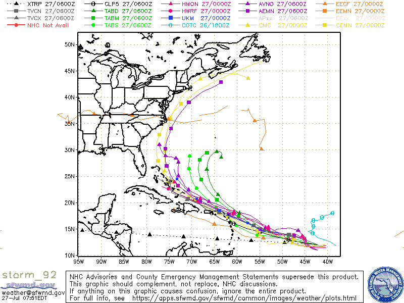
This is certainly true, but even with strong ridging in place, long-tracking systems of African—that is, AEW-related—origin that develop in the MDR are more likely than not to curve at some point, whether offshore or over/near land. The EPS, like the ICON, has been consistently suggesting at least a temporary weakness in six or seven days, given that a shortwave is shown to be lifting out at that time in advance of the next one, while ridging attempts to “bridge” in its wake. So if 98L were over/near South Florida at that time, it would be very close to the western edge of the Western Atlantic Ridge (WAR), and would be nearing a gap between the expanding Sonoran heat ridge and the WAR. Combined with the climatological salience I mentioned, this might imply that 98L would assume a west-northwestward track toward the south-central Bahamas and the Miami area, avoiding the Keys and the Greater Antilles to the north, and then curve northwestward and northward toward Tampa Bay and the Big Bend (Cedar Key). So maybe the evolution will run as follows: south-central Bahamas → Miami (landfall) → Tampa Bay → Cedar Key. Perhaps the trajectory will be somewhat similar to that of the 
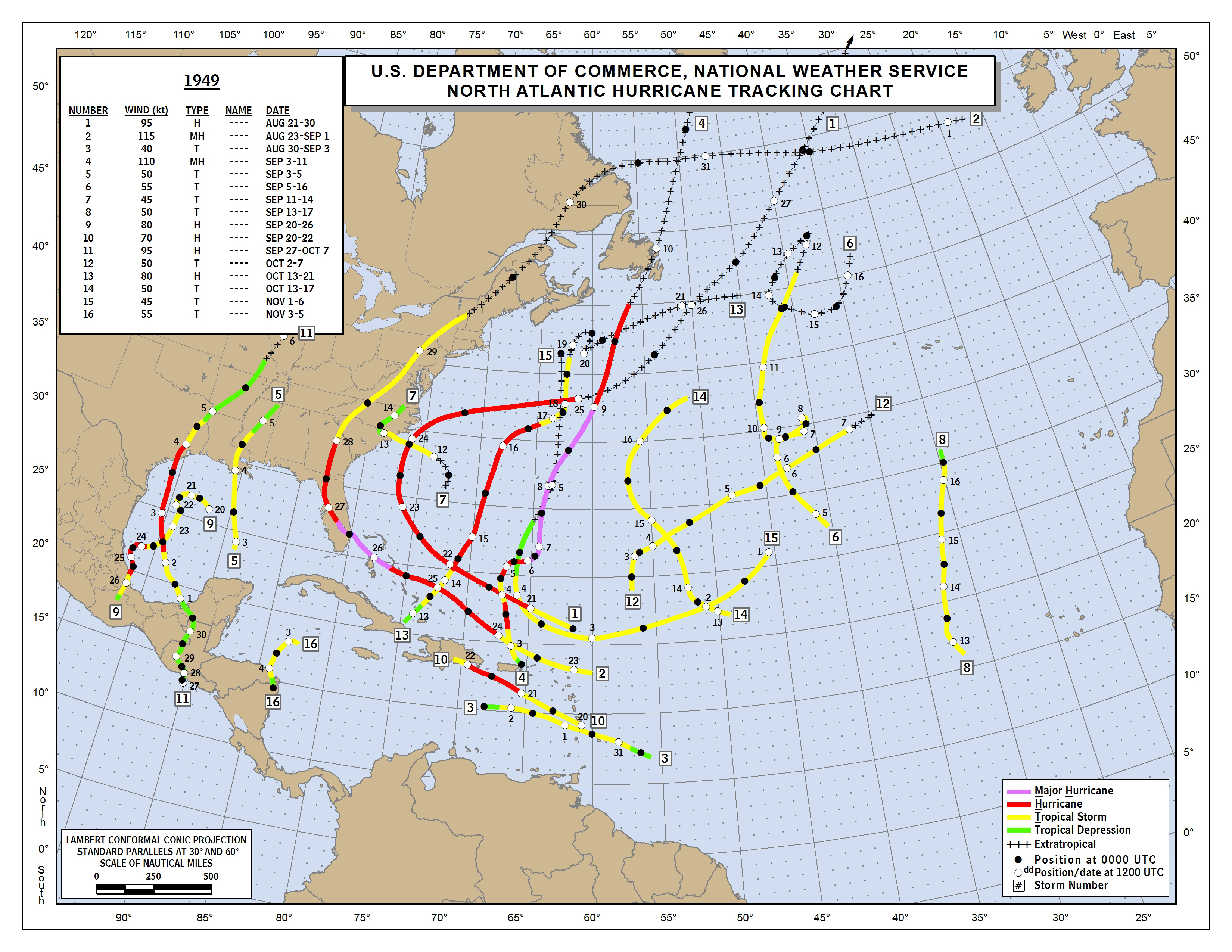
1949 Palm Beach hurricane, except that the initial landfall will be farther south, in the Miami area. We shall see.
Last edited by Shell Mound on Tue Aug 18, 2020 11:32 pm, edited 2 times in total.
0 likes   
CVW / MiamiensisWx / Shell Mound
The posts in this forum are NOT official forecasts and should not be used as such. They are just the opinion of the poster and may or may not be backed by sound meteorological data. They are NOT endorsed by any professional institution or STORM2K. For official information, please refer to products from the NHC and NWS.

User avatar
Blown Away
S2K Supporter
S2K Supporter
Posts: 10145
Joined: Wed May 26, 2004 6:17 am

Re: ATL: INVEST 98L - Models

#590 Postby Blown Away » Tue Aug 18, 2020 11:26 pm

00z GFS much slower
0 likes   
Hurricane Eye Experience: David 79, Irene 99, Frances 04, Jeanne 04, Wilma 05... EYE COMING MY WAY IN 2024…
Hurricane Brush Experience: Andrew 92, Erin 95, Floyd 99, Matthew 16, Irma 17, Ian 22, Nicole 22…

User avatar
eastcoastFL
Category 5
Category 5
Posts: 3901
Age: 43
Joined: Thu Apr 12, 2007 12:29 pm
Location: Palm City, FL

Re: ATL: INVEST 98L - Models

#591 Postby eastcoastFL » Tue Aug 18, 2020 11:27 pm

HMON is running now. Normally I’d skip this one and head to bed but I’m hooked
2 likes   
Personal Forecast Disclaimer:
The posts in this forum are NOT official forecast and should not be used as such. They are just the opinion of the poster and may or may not be backed by sound meteorological data. They are NOT endorsed by any professional institution or storm2k.org. For official information, please refer to the NHC and NWS products.

User avatar
Evil Jeremy
S2K Supporter
S2K Supporter
Posts: 5463
Age: 32
Joined: Mon Apr 10, 2006 2:10 pm
Location: Los Angeles, CA

Re: ATL: INVEST 98L - Models

#592 Postby Evil Jeremy » Tue Aug 18, 2020 11:27 pm

For some perspective:

Current model plot for 98L: https://apps.sfwmd.gov/sfwmd/common/ima ... orm_98.gif
Comparable plot for 92L (eventually Isaias): https://flhurricane.com/images/2020/sto ... 7-0756.gif
0 likes   
Frances 04 / Jeanne 04 / Katrina 05 / Wilma 05 / Fay 08 / Debby 12 / Andrea 13 / Colin 16 / Hermine 16 / Matthew 16 / Irma 17

User avatar
toad strangler
S2K Supporter
S2K Supporter
Posts: 4543
Joined: Sun Jul 28, 2013 3:09 pm
Location: Earth
Contact:

Re: ATL: INVEST 98L - Models

#593 Postby toad strangler » Tue Aug 18, 2020 11:27 pm

12z CMC no genesis through 72hrs but will clear PR to the N
0 likes   

User avatar
eastcoastFL
Category 5
Category 5
Posts: 3901
Age: 43
Joined: Thu Apr 12, 2007 12:29 pm
Location: Palm City, FL

Re: ATL: INVEST 98L - Models

#594 Postby eastcoastFL » Tue Aug 18, 2020 11:28 pm

GFS slowing and weakening in the Northern GOM
0 likes   
Personal Forecast Disclaimer:
The posts in this forum are NOT official forecast and should not be used as such. They are just the opinion of the poster and may or may not be backed by sound meteorological data. They are NOT endorsed by any professional institution or storm2k.org. For official information, please refer to the NHC and NWS products.

User avatar
FLpanhandle91
Category 5
Category 5
Posts: 1033
Age: 34
Joined: Mon Sep 13, 2010 3:50 pm
Location: Fort Walton Beach, FL

Re: ATL: INVEST 98L - Models

#595 Postby FLpanhandle91 » Tue Aug 18, 2020 11:28 pm

Seems like GFS drops most steering at the 500mb level by the time it emerges in the Gulf and 98L really slows down. Could have quite a bit of time in the Gulf if this run verifies.
0 likes   

Keldeo1997
Category 2
Category 2
Posts: 637
Joined: Fri Oct 11, 2019 11:35 pm

Re: ATL: INVEST 98L - Models

#596 Postby Keldeo1997 » Tue Aug 18, 2020 11:28 pm

GFS is stalling Dorian style just right before landfall in the MS/AL gulf coast
0 likes   

WeatherEmperor
S2K Supporter
S2K Supporter
Posts: 4806
Age: 41
Joined: Thu Sep 04, 2003 2:54 pm
Location: South Florida

Re: ATL: INVEST 98L - Models

#597 Postby WeatherEmperor » Tue Aug 18, 2020 11:30 pm

The model roaler coaster continues. Canadian comes in much weaker

Image


Sent from my iPhone using Tapatalk
0 likes   

User avatar
eastcoastFL
Category 5
Category 5
Posts: 3901
Age: 43
Joined: Thu Apr 12, 2007 12:29 pm
Location: Palm City, FL

Re: ATL: INVEST 98L - Models

#598 Postby eastcoastFL » Tue Aug 18, 2020 11:30 pm

Evil Jeremy wrote:For some perspective:

Current model plot for 98L: https://apps.sfwmd.gov/sfwmd/common/ima ... orm_98.gif
Comparable plot for 92L (eventually Isaias): https://flhurricane.com/images/2020/sto ... 7-0756.gif

A lot more recurve for Isa.
0 likes   
Personal Forecast Disclaimer:
The posts in this forum are NOT official forecast and should not be used as such. They are just the opinion of the poster and may or may not be backed by sound meteorological data. They are NOT endorsed by any professional institution or storm2k.org. For official information, please refer to the NHC and NWS products.

stormlover2013

Re: ATL: INVEST 98L - Models

#599 Postby stormlover2013 » Tue Aug 18, 2020 11:31 pm

Cmc is pretty good bit south
0 likes   

User avatar
toad strangler
S2K Supporter
S2K Supporter
Posts: 4543
Joined: Sun Jul 28, 2013 3:09 pm
Location: Earth
Contact:

Re: ATL: INVEST 98L - Models

#600 Postby toad strangler » Tue Aug 18, 2020 11:31 pm

@90hrs the CMC is hangin out with the GFS and getting tangled up in the GA's as an undeveloped wave
0 likes   


Return to “2020”

Who is online

Users browsing this forum: No registered users and 3 guests