ATL: LAURA - Post-Tropical - Discussion
Moderator: S2k Moderators
-
Do_For_Love
- Category 1

- Posts: 271
- Age: 35
- Joined: Sat May 09, 2015 7:47 am
- Location: Delaware
Re: ATL: LAURA - Hurricane - Discussion
It seems like Laura has pulsed a bit in strength since this morning, but there is a newish burst of convection with pink cloud tops on the IR. She's only predicted to be at 85 mph by 11pm according to the NHC, so she doesn't have to strengthen much today in order to be on track for major status.
2 likes
Irene '11, Sandy '12, Fay '20, Isaias '20, Ida '21
Re: ATL: LAURA - Hurricane - Discussion
zhukm29 wrote:Higher stability air is wrapping around right now, which could reduce significant intensification in the short term (the next few hours). Once that is mixed out, we could see faster RI. Luckily, this means that Laura will have less time to take advantage of perfect conditions - I'd estimate a C3 or low C4 at landfall. Anything higher is still possible (but looking less likely with this short pause in intensification), since it would require a herculean bout of RI. Luckily, C5 is looking unlikely now. (That being said, storms have done this before, so it is still important to be vigilant).
It seems like a 930-945 mbar storm is looking more likely than <930 mbar. If Laura will have a similar RI phase to Katrina in the next 36 hours (~1.4mbar/hr pressure drop), it’ll bottom out in the high 930s or low 940s. However, if it’s like Rita’s RI phase (~2.4mbar/hr), it could go below 910 mbar.
If it were to exceed all of our expectations and go for a completely bonkers RI phase like Amphan this May (~3mbar/hr), it could drop below 900-890 mbar. It’s safe to say something like that is extremely unlikely.
Last edited by aspen on Tue Aug 25, 2020 12:28 pm, edited 2 times in total.
6 likes
Irene '11 Sandy '12 Hermine '16 5/15/2018 Derecho Fay '20 Isaias '20 Elsa '21 Henri '21 Ida '21
I am only a meteorology enthusiast who knows a decent amount about tropical cyclones. Look to the professional mets, the NHC, or your local weather office for the best information.
I am only a meteorology enthusiast who knows a decent amount about tropical cyclones. Look to the professional mets, the NHC, or your local weather office for the best information.
Re: ATL: LAURA - Hurricane - Discussion
Looking a lot like it did yesterday with that dry slot.
0 likes
Igor 2010, Sandy 2012, Fay 2014, Gonzalo 2014, Joaquin 2015, Nicole 2016, Humberto 2019, Imelda 2025
I am only a tropical weather enthusiast. My predictions are not official and may or may not be backed by sound meteorological data. For official information, please refer to the NHC and NWS products.
I am only a tropical weather enthusiast. My predictions are not official and may or may not be backed by sound meteorological data. For official information, please refer to the NHC and NWS products.
Re: ATL: LAURA - Hurricane - Discussion
It's the organizational process happening today that will permit the strengthening down the road. Laura has been taking her time over the course of its life but it gets the work done over time. She's a cat 5 in terms of tenacity.
6 likes
Re: ATL: LAURA - Hurricane - Discussion
LSU Saint wrote:Blinhart wrote:Beef Stew wrote:A lot of the models that show more pronounced RI start doing so late tonight after 03z, and continue through late tomorrow. Likewise, the NHC only is forecasting 'modest' strengthening (10 mph increase for a total of 85mph sustained) over the next ~10 hours, before doubling that rate (a 20 mph increase to 105mph by 15z tomorrow) overnight. Laura doesn't look fantastic right now (which isn't to say she looks unhealthy by any stretch) due to the slight weakness in her NW region, but she's probably just tabled off for now. While she may not blow up this afternoon/evening, it probably means little if anything in regards to her chances to drastically intensify after the next 10 hours.
I still unfortunately expect this to get to high Cat 4 if not Cat 5 before starting to slowly going down in strength right before landfall in between Sabine Pass and Grand Chenier, La.
Wouldn’t a Cat 4 or 5 push the storm west?
Not necessarily that but if it goes more westerly that means more time over warm water = stronger storm
0 likes
Re: ATL: LAURA - Hurricane - Discussion
psyclone wrote:It's the organizational process happening today that will permit the strengthening down the road. Laura has been taking her time over the course of its life but it gets the work done over time. She's a cat 5 in terms of tenacity.
Agree...Michael didn't take right off after it entered the GOM. Over the last 36 hours of it's lifetime the RI was phenomenal and pressure was still dropping as it came ashore.
1 likes
Re: ATL: LAURA - Hurricane - Discussion
Would appear to be intensifying again.
1 likes
Very useful information on the Dvorak Technique --
https://severe.worldweather.wmo.int/TCF ... kBeven.pdf
https://severe.worldweather.wmo.int/TCF ... kBeven.pdf
Re: ATL: LAURA - Hurricane - Discussion
CAPE increasing to 6000 NW of the CoC.
Likely thunderstorms will fire here in a few hours and moisten the mid-levels where it appears to be currently dry.

Likely thunderstorms will fire here in a few hours and moisten the mid-levels where it appears to be currently dry.

3 likes
Re: ATL: LAURA - Hurricane - Discussion
1 likes
Irene '11 Sandy '12 Hermine '16 5/15/2018 Derecho Fay '20 Isaias '20 Elsa '21 Henri '21 Ida '21
I am only a meteorology enthusiast who knows a decent amount about tropical cyclones. Look to the professional mets, the NHC, or your local weather office for the best information.
I am only a meteorology enthusiast who knows a decent amount about tropical cyclones. Look to the professional mets, the NHC, or your local weather office for the best information.
- FLpanhandle91
- Category 5

- Posts: 1039
- Age: 34
- Joined: Mon Sep 13, 2010 3:50 pm
- Location: Fort Walton Beach, FL
Re: ATL: LAURA - Hurricane - Discussion
cheezyWXguy wrote:I don’t think it’s going to look like this much longer, there are some subtle hints on visible this has bottomed out. For one, outflow is improving in all quadrants, even on the west side, if only gradually. Second, the area where the southern eyewall should be is starting to fill in a little bit. There was some weird vort on the nw side as well that seems to have largely dissipated.
I believe some were confusing that vort with the center. The LLC is pretty much underneath all of the expanding CDO.
1 likes
-
hurricaneCW
- Category 5

- Posts: 1799
- Joined: Wed Mar 03, 2010 6:20 am
- Location: Toms River, NJ
Re: ATL: LAURA - Hurricane - Discussion
Outflow is beginning to expand on its northern side, a good indication of shear relaxation and a moistening atmosphere.
3 likes
ATL: LAURA - Hurricane - Discussion
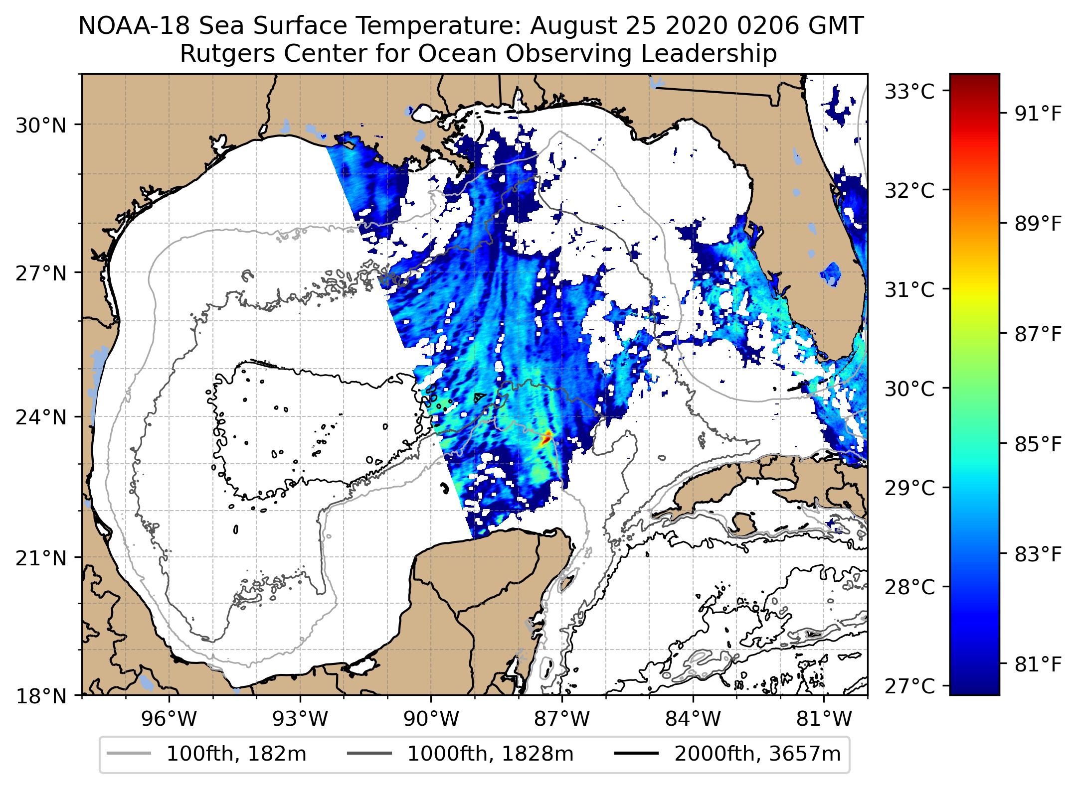
How it reacts to passing over the Loop Current coming up from the Yucatan Channel will tell you a lot...
0 likes
- Hypercane_Kyle
- Category 5

- Posts: 3465
- Joined: Sat Mar 07, 2015 7:58 pm
- Location: Cape Canaveral, FL
Re: ATL: LAURA - Hurricane - Discussion
hurricaneCW wrote:Outflow is beginning to expand on its northern side, a good indication of shear relaxation and a moistening atmosphere.
Yea, you can see the cirrus clouds starting to move away to the north. One of the things to watch for is if it can develop polar outflow channels today.

1 likes
My posts are my own personal opinion, defer to the National Hurricane Center (NHC) and other NOAA products for decision making during hurricane season.
Re: ATL: LAURA - Hurricane - Discussion
Blow_Hard wrote:psyclone wrote:It's the organizational process happening today that will permit the strengthening down the road. Laura has been taking her time over the course of its life but it gets the work done over time. She's a cat 5 in terms of tenacity.
Agree...Michael didn't take right off after it entered the GOM. Over the last 36 hours of it's lifetime the RI was phenomenal and pressure was still dropping as it came ashore.
You're right. You need to construct a foundation before you can build that jenga tower of steam (which is the goofy way i envision a cane). Michael looked grungey and smudgey relative to its strength until it neared landfall. So did Joaquin in 2015. This system has the comma shape that often (but not always) precedes significant intensification. A major or near major hurricane still seems like a reasonable bet. I'd need to see a lot more before buying into the extreme solutions. thankfully those don't happen very often.
4 likes
Re: ATL: LAURA - Hurricane - Discussion
Time for model runs! I would give a fiver to take a peak at this afternoon's FSU ensemble! This is the time where the track really firms up and this 5pm update is the most critical since Michael and Dorian.
1 likes
The following post is NOT an official forecast and should not be used as such. It is just the opinion of the poster and may or may not be backed by sound meteorological data. It is NOT endorsed by any professional institution including storm2k.org For Official Information please refer to the NHC and NWS products.
Re: ATL: LAURA - Hurricane - Discussion
Pretty intense band heading towards mobile in a few hours. We’ll see if it holds together
1 likes
- p1nheadlarry
- Category 2

- Posts: 672
- Age: 34
- Joined: Wed Jan 29, 2014 2:42 pm
- Location: SR County FL
Re: ATL: LAURA - Hurricane - Discussion
FWIW, the cold pool is depicting total heat content. The areas near the cold pool are still >= 79 C. 
Perhaps a cooler boundary layer => lower enthalpy flux => low entropy air at the low levels but this is likely sufficient to maintain it's current intensity.
edit units

Perhaps a cooler boundary layer => lower enthalpy flux => low entropy air at the low levels but this is likely sufficient to maintain it's current intensity.
edit units
Last edited by p1nheadlarry on Tue Aug 25, 2020 3:27 pm, edited 1 time in total.
2 likes
--;->#GoNoles--;->.
Re: ATL: LAURA - Hurricane - Discussion
Wow that was really quick.
Laura swallowed that high CAPE air like there was no tomorrow.
Up to 3000 in the core in the matter of 15 minutes.
Ice imagery showing CDO expanding to the NW.
Afraid to think what happens tomorrow when she starts swallowing the really heavy-duty CAPE air off the TX / LA coast.
Laura swallowed that high CAPE air like there was no tomorrow.
Up to 3000 in the core in the matter of 15 minutes.
Ice imagery showing CDO expanding to the NW.
Afraid to think what happens tomorrow when she starts swallowing the really heavy-duty CAPE air off the TX / LA coast.
3 likes
-
jlauderdal
- S2K Supporter

- Posts: 7240
- Joined: Wed May 19, 2004 5:46 am
- Location: NE Fort Lauderdale
- Contact:
Re: ATL: LAURA - Hurricane - Discussion
we know where its going...less than 75 miles either side of the NHC line...getting in the time frame where NHC is superior to the models, they can fine tune far better than nay model at this rangesponger wrote:Time for model runs! I would give a fiver to take a peak at this afternoon's FSU ensemble! This is the time where the track really firms up and this 5pm update is the most critical since Michael and Dorian.
2 likes
Who is online
Users browsing this forum: No registered users and 4 guests


