2020 Global Model Runs Discussion (Out thru day 16)

This is the general tropical discussion area. Anyone can take their shot at predicting a storms path.

Moderator: S2k Moderators

Forum rules

The posts in this forum are NOT official forecasts and should not be used as such. They are just the opinion of the poster and may or may not be backed by sound meteorological data. They are NOT endorsed by any professional institution or STORM2K. For official information, please refer to products from the National Hurricane Center and National Weather Service.

Help Support Storm2K
Message
Author
User avatar
NDG
S2K Supporter
S2K Supporter
Posts: 15446
Joined: Sun Jul 09, 2006 10:14 pm
Location: Orlando, FL

Re: 2020 Global Model Runs Discussion (Out thru day 16)

#1941 Postby NDG » Thu Sep 03, 2020 9:57 am

SFLcane wrote:
NDG wrote:
SFLcane wrote:
Just looks like the ridge is pretty far N. Looks like a lot of weakness to the NE too. Escape hatch will be open

Ridge would need to be reinforced a lot more


This is what a guaranteed OTS pattern looks like, 2010, as an example. Nothing close to what models are showing.

https://i.imgur.com/wPY7U1a.gif


NDG, that is what the EPS basically has at Day 15. Not quite that pronounced we will see if that evolves.

https://i.postimg.cc/jSRzTTzn/5-F4029-C8-7-BE1-48-FA-A96-F-4-D91-D0652-F98.jpg


It can either way at day 15 this far out.
Last edited by NDG on Thu Sep 03, 2020 10:11 am, edited 1 time in total.
0 likes   

St0rmTh0r
Category 1
Category 1
Posts: 369
Joined: Tue Jul 14, 2020 8:04 pm

Re: 2020 Global Model Runs Discussion (Out thru day 16)

#1942 Postby St0rmTh0r » Thu Sep 03, 2020 10:02 am

The models severely nerfed the strength of the ridge pre Laura. Gfs had several OTS runs if I remember correct. Looks like the same situation here.
6 likes   

User avatar
CyclonicFury
Category 5
Category 5
Posts: 2026
Age: 26
Joined: Sun Jul 02, 2017 12:32 pm
Location: NC
Contact:

Re: 2020 Global Model Runs Discussion (Out thru day 16)

#1943 Postby CyclonicFury » Thu Sep 03, 2020 10:23 am

If I remember correctly, the earliest EPS runs for Irma had it recurving near Cabo Verde. A lot can change this far out...but the deeper you get into September the lower the chance of a Cabo Verde system making it all the way west to the United States.
6 likes   
NCSU B.S. in Meteorology Class of 2021. Tropical weather blogger at http://www.cyclonicfury.com. My forecasts and thoughts are NOT official, for official forecasts please consult the National Hurricane Center.

User avatar
toad strangler
S2K Supporter
S2K Supporter
Posts: 4543
Joined: Sun Jul 28, 2013 3:09 pm
Location: Earth
Contact:

Re: 2020 Global Model Runs Discussion (Out thru day 16)

#1944 Postby toad strangler » Thu Sep 03, 2020 10:29 am

Again, no perfect thread to put this. Next year we should have a General Atlantic Basin thread for cool tidbits like this :)

 https://twitter.com/TylerJStanfield/status/1301539383426850818


8 likes   

LarryWx
S2K Supporter
S2K Supporter
Posts: 6323
Joined: Sun Sep 07, 2003 2:04 pm
Location: GA

Re: 2020 Global Model Runs Discussion (Out thru day 16)

#1945 Postby LarryWx » Thu Sep 03, 2020 10:50 am

SFLcane wrote:
NDG wrote:
TheStormExpert wrote:GFS, and Euro/EPS show nothing but fish storms with potential impacts to Bermuda. I don’t see the ridge you’ll are talking about.


Writing the tracks on stone from the GFS and Euro's long range forecast is not a good idea when ensembles show strong ridging north of Bermuda, like I said, any OTS tracks will have to be well east of Bermuda. There is no trough pattern being forecasted for the eastern US for them to recurve OTS over or west of Bermuda.


https://i.imgur.com/yMemFxM.gif


It's the trough under the ridge that's the thing. Notice that retrograding ULL That's what's gonna serve as the recurve mechanism at least for the first system or two.

Large weakness “ trap door “

https://i.postimg.cc/5NfNbjFq/60-C45865-5-C07-4-A20-9-AB7-8-C2134196-C8-A.jpg


As we all know, TCs have a strong tendency to move poleward. All they really need is a slight weakness in an overall ridging pattern to the north as that’s often enough to get it to recurve well OTS. Doing that is almost like a default.

What I’ve found over the years is that a new 500 mb ridge being established to the N is the type of thing that most easily keeps a TC from its typical recurve for at least several days. When a new 500 mb ridge appears in the far W Atlantic, that’s often the most dangerous for the E coast of the US because recurving well OTS becomes difficult. But OTOH, older ridges are more apt to allow enough weakness to eventually allow for an easier recurve. After a certain point like a few days to a week after a new upper ridge is established, that particular upper ridge will often then start to weaken. That’s when recurve potential increases through finding a weakness. Sometimes though a second upper ridge then forms thus then at least temporarily halting the recurve with a likely leftward bend. That can be dangerous, too.
4 likes   
Personal Forecast Disclaimer:
The posts in this forum are NOT official forecasts and should not be used as such. They are just the opinion of the poster and may or may not be backed by sound meteorological data. They are NOT endorsed by any professional institution or storm2k.org. For official information, please refer to the NHC and NWS products.

User avatar
SFLcane
S2K Supporter
S2K Supporter
Posts: 10163
Age: 47
Joined: Sat Jun 05, 2010 1:44 pm
Location: Lake Worth Florida

Re: 2020 Global Model Runs Discussion (Out thru day 16)

#1946 Postby SFLcane » Thu Sep 03, 2020 10:56 am

0 likes   

User avatar
GCANE
S2K Supporter
S2K Supporter
Posts: 11500
Joined: Mon Oct 22, 2007 8:03 am

Re: 2020 Global Model Runs Discussion (Out thru day 16)

#1947 Postby GCANE » Thu Sep 03, 2020 11:09 am

toad strangler wrote:Again, no perfect thread to put this. Next year we should have a General Atlantic Basin thread for cool tidbits like this :)

https://twitter.com/TylerJStanfield/status/1301539383426850818?s=20


There should be a thread called "Atlantic Monsoon Trough"
3 likes   

User avatar
NDG
S2K Supporter
S2K Supporter
Posts: 15446
Joined: Sun Jul 09, 2006 10:14 pm
Location: Orlando, FL

Re: 2020 Global Model Runs Discussion (Out thru day 16)

#1948 Postby NDG » Thu Sep 03, 2020 11:16 am


I get mixed feelings from you all the time, so which pattern do you agree with? OTS or potential threats to the US? :lol:
7 likes   

User avatar
SFLcane
S2K Supporter
S2K Supporter
Posts: 10163
Age: 47
Joined: Sat Jun 05, 2010 1:44 pm
Location: Lake Worth Florida

Re: 2020 Global Model Runs Discussion (Out thru day 16)

#1949 Postby SFLcane » Thu Sep 03, 2020 11:41 am

NDG wrote:


I get mixed feelings from you all the time, so which pattern do you agree with? OTS or potential threats to the US? :lol:


We call all speculate... Again for now it looks like a pretty classic setup for the first few waves to recurve. Again the retrograding ULL is in what I believe could be what serves as the recurve mechanism.
0 likes   

User avatar
gatorcane
S2K Supporter
S2K Supporter
Posts: 23691
Age: 47
Joined: Sun Mar 13, 2005 3:54 pm
Location: Boca Raton, FL

Re: 2020 Global Model Runs Discussion (Out thru day 16)

#1950 Postby gatorcane » Thu Sep 03, 2020 11:52 am

The much improved CMC shows an active train of weak Cape Verde storms recurving:

Image
1 likes   

AutoPenalti
Category 5
Category 5
Posts: 4030
Age: 29
Joined: Mon Aug 17, 2015 4:16 pm
Location: Ft. Lauderdale, Florida

Re: 2020 Global Model Runs Discussion (Out thru day 16)

#1951 Postby AutoPenalti » Thu Sep 03, 2020 11:56 am

Hey cool! We are back to the GFS and Euro “strong trough vs strong ridge” competition.
5 likes   
The posts in this forum are NOT official forecasts and should not be used as such. They are just the opinion of the poster and may or may not be backed by sound meteorological data. They are NOT endorsed by any professional institution or STORM2K. For official information, please refer to products from the NHC and NWS.


Model Runs Cheat Sheet:
GFS (5:30 AM/PM, 11:30 AM/PM)
HWRF, GFDL, UKMET, NAVGEM (6:30-8:00 AM/PM, 12:30-2:00 AM/PM)
ECMWF (1:45 AM/PM)

TCVN
is a weighted averaged

User avatar
CyclonicFury
Category 5
Category 5
Posts: 2026
Age: 26
Joined: Sun Jul 02, 2017 12:32 pm
Location: NC
Contact:

Re: 2020 Global Model Runs Discussion (Out thru day 16)

#1952 Postby CyclonicFury » Thu Sep 03, 2020 11:59 am

gatorcane wrote:The much improved CMC shows an active train of weak Cape Verde storms recurving:

https://i.postimg.cc/fbZKB75J/gem-mslpa-Norm-atl-39.png

The CMC seems unable to develop anything stronger than 980 mb. I wouldn't trust it for intensity, though for genesis this year it has been decent.
1 likes   
NCSU B.S. in Meteorology Class of 2021. Tropical weather blogger at http://www.cyclonicfury.com. My forecasts and thoughts are NOT official, for official forecasts please consult the National Hurricane Center.

shiny-pebble
Category 1
Category 1
Posts: 299
Joined: Thu Jul 05, 2018 1:38 pm

Re: RE: Re: 2020 Global Model Runs Discussion (Out thru day 16)

#1953 Postby shiny-pebble » Thu Sep 03, 2020 12:00 pm

CyclonicFury wrote:
gatorcane wrote:The much improved CMC shows an active train of weak Cape Verde storms recurving:

https://i.postimg.cc/fbZKB75J/gem-mslpa-Norm-atl-39.png

The CMC seems unable to develop anything stronger than 980 mb. I wouldn't trust it for intensity, though for genesis this year it has been decent.
Agreed, it's been superb at MDR genesis but struggles to get storms intense. It maxed Laura out at like 970 if I remember correctly

Sent from my SM-G970U using Tapatalk
0 likes   
Not an meteorologist! Just someone who is interested in weather. Please refer to the NHC and local weather officials to make decisions.
-Jack 8-)

User avatar
SFLcane
S2K Supporter
S2K Supporter
Posts: 10163
Age: 47
Joined: Sat Jun 05, 2010 1:44 pm
Location: Lake Worth Florida

Re: 2020 Global Model Runs Discussion (Out thru day 16)

#1954 Postby SFLcane » Thu Sep 03, 2020 12:08 pm

1 likes   

Nuno
Category 2
Category 2
Posts: 597
Joined: Fri Aug 30, 2019 8:35 am
Location: Coral Gables, FL

Re: 2020 Global Model Runs Discussion (Out thru day 16)

#1955 Postby Nuno » Thu Sep 03, 2020 12:12 pm

I'm getting mixed signals from the models AND posters. One day its recurve city, the next is monster ridge with nowhere to go but west :lol:
10 likes   
Andrew (1992), Irene (1999), Frances (2004), Katrina (2005), Wilma (2005), Fay (2008), Irma (2017), Eta (2020), Ian (2022)

Cat5James
Category 1
Category 1
Posts: 417
Joined: Fri Sep 06, 2019 7:54 pm

Re: 2020 Global Model Runs Discussion (Out thru day 16)

#1956 Postby Cat5James » Thu Sep 03, 2020 12:50 pm

Nuno wrote:I'm getting mixed signals from the models AND posters. One day its recurve city, the next is monster ridge with nowhere to go but west :lol:

Thats because nobody (including the models) has a clue how this is going to play out... the inconsistency from model run to run is astounding.
2 likes   

User avatar
MississippiWx
S2K Supporter
S2K Supporter
Posts: 1699
Joined: Sat Aug 14, 2010 1:44 pm
Location: Hattiesburg, Mississippi

Split - 2020 Global Model Runs Discussion (Out thru day 16)

#1957 Postby MississippiWx » Thu Sep 03, 2020 12:53 pm

Nuno wrote:I'm getting mixed signals from the models AND posters. One day its recurve city, the next is monster ridge with nowhere to go but west :lol:


I tend to let a system develop first. With the way the monsoon trough is this season, we have a huge headache for models. It's difficult for them to consolidate one or multiple waves into TCs. We should have a clearer idea by the weekend. I think the main point to take home is that an uptick in TC activity is coming. Track will depend on many variables, including strength.

One thing I'm fairly certain about is we aren't about to see 40 degree F temps in South MS in early September. The GFS is on crack.
7 likes   
This post is not an official forecast and should not be used as such. It is just the opinion of MississippiWx and may or may not be backed by sound meteorological data. It is not endorsed by any professional institution including storm2k.org. For Official Information please refer to the NHC and NWS products.

USTropics
Professional-Met
Professional-Met
Posts: 2659
Joined: Sun Aug 12, 2007 3:45 am
Location: Florida State University

Re: 2020 Global Model Runs Discussion (Out thru day 16)

#1958 Postby USTropics » Thu Sep 03, 2020 1:01 pm

Cat5James wrote:
Nuno wrote:I'm getting mixed signals from the models AND posters. One day its recurve city, the next is monster ridge with nowhere to go but west :lol:

Thats because nobody (including the models) has a clue how this is going to play out... the inconsistency from model run to run is astounding.


The evolution of this setup is extremely complex - we're likely to see a huge hit to model verification scores with just the upper-level pattern over NA. The global models are going to continue showing varying solutions, even the ensembles are having a difficult time. Just look at the adjustments from both the GFS and CMC ensembles over the past 6 runs alone:

GFS ensembles
Image

CMC ensembles
Image

That's before you even consider the evolution of the monsoon gyre over EATL and how that evolution will play out (another difficult process for the models to forecast). Basically, stay tuned for now. The only takeaway at this point is there are likely to be numerous areas of genesis, tracks are still to be determined with any real confidence.
6 likes   

User avatar
Steve
S2K Supporter
S2K Supporter
Posts: 9621
Joined: Sat Apr 05, 2003 11:41 pm
Location: Not a state-caster

Re: 2020 Global Model Runs Discussion (Out thru day 16)

#1959 Postby Steve » Thu Sep 03, 2020 1:24 pm

MississippiWx wrote:
Nuno wrote:I'm getting mixed signals from the models AND posters. One day its recurve city, the next is monster ridge with nowhere to go but west :lol:

I tend to let a system develop first. With the way the monsoon trough is this season, we have a huge headache for models. It's difficult for them to consolidate one or multiple waves into TCs. We should have a clearer idea by the weekend. I think the main point to take home is that an uptick in TC activity is coming. Track will depend on many variables, including strength.

One thing I'm fairly certain about is we aren't about to see 40 degree F temps in South MS in early September. The GFS is on crack.

GFS does find 2 systems developing in the MDR, both of which recurve before 60W. It also develops an STS/Nor'easter off the mid-Atlantic Coast.

ICON develops 3; one ends up at 50/20 at 180 hours, the second moves NW/NNW into the Atlantic Ocean and the other behind it is still forming off the coast of Africa.

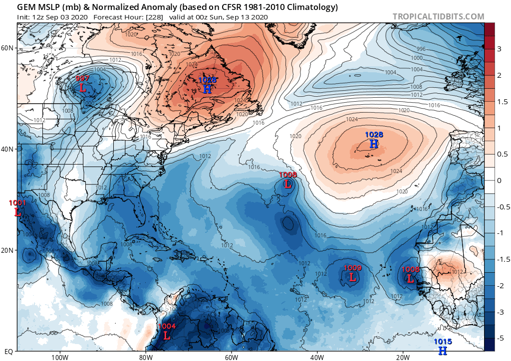
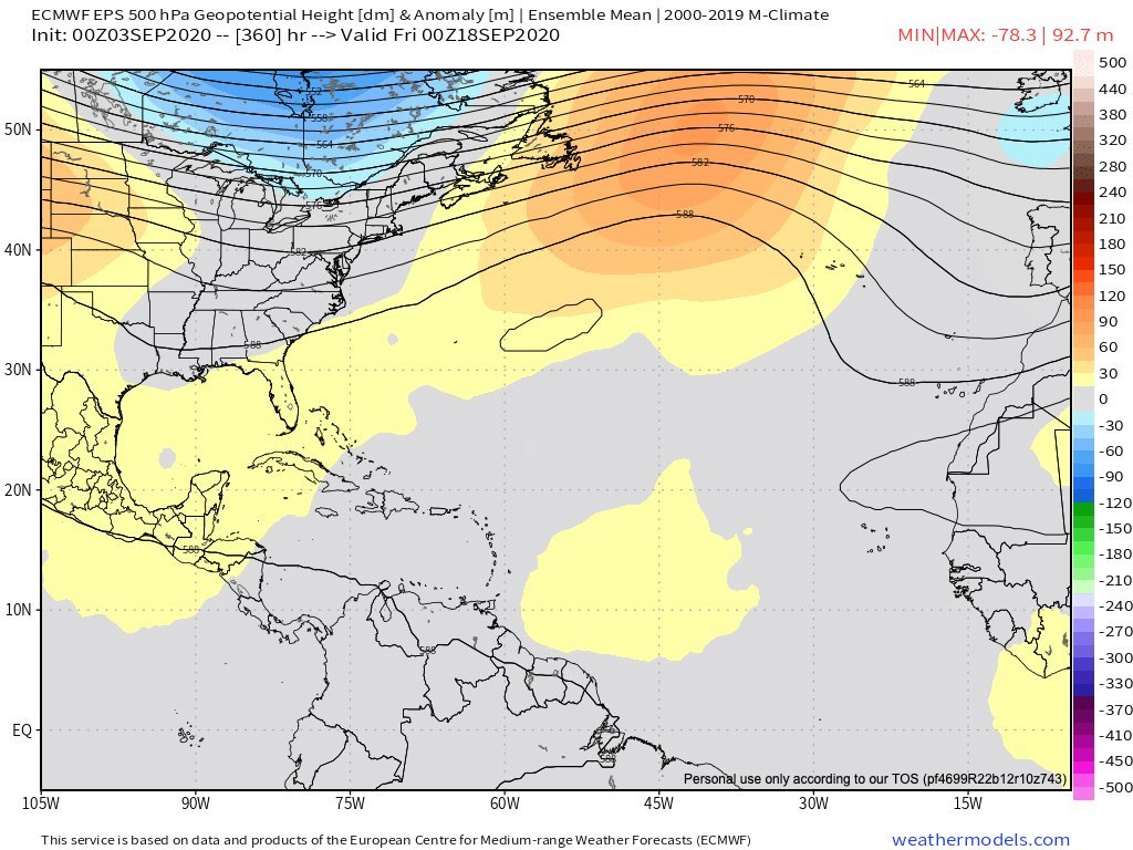
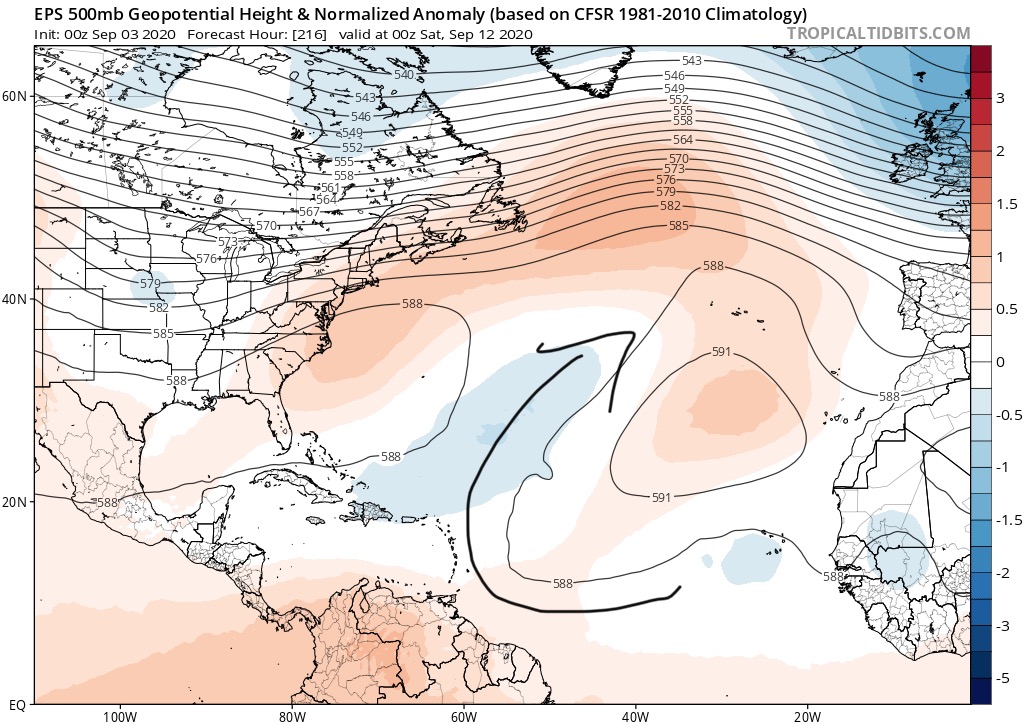
CMC, as Gatorcane noted, shows about 4 systems on recurve tracks. Some of that isn't particularly believable as reinforcement ridging is coming off the US East Coast and is not taken into account with any bend back tracks.

Most of the Dynamical Models want to take the MJO toward Phase IV (Maritime Continent). CFS loops it into the circle and likes it back in Phase 3 more or less.
0 likes   

LarryWx
S2K Supporter
S2K Supporter
Posts: 6323
Joined: Sun Sep 07, 2003 2:04 pm
Location: GA

Re: 2020 Global Model Runs Discussion (Out thru day 16)

#1960 Postby LarryWx » Thu Sep 03, 2020 1:29 pm

The fact is that there are significantly fewer ensemble members on all runs through 12Z on both the GEFS and Para GEFS that hit or even come close to the Bahamas and CONUS vs runs of 24-30 hours ago. Also, the CMC and Euro ensembles have had very few members even threatening since 12Z yesterday. That much is factual info and that should be considered in assessing the chances of these areas being threatened. I guarantee that if it were the other way around, all the talk here would be about the more threatening ensembles. Because most folks want more to talk about and who find it much more interesting if there is a potential threat, there is going to be a natural bias toward downplaying model trends going in the less threatening direction/finding reasons the models may be off and up-playing model trends going in the more threatening direction and not trying as hard to find reasons they’re off.

I’m observed that posts that have a more threatening tone tend to get more likes on average than those that do the opposite. That’s the nature of a typical wx bb.

I like to consider myself a neutral observer as regards reporting on objective model trends.

So, to summarize, the objective model trends have clearly gone in the less threatening direction vs 24 hours ago whether that trend is downplayed or not.

That being said, there’s a long way to go and the models could always trend back the other way. But my bigger concern is not that I think they’ll necessarily trend back the other way but that there could be another system that may not even exist yet that could threaten.
4 likes   
Personal Forecast Disclaimer:
The posts in this forum are NOT official forecasts and should not be used as such. They are just the opinion of the poster and may or may not be backed by sound meteorological data. They are NOT endorsed by any professional institution or storm2k.org. For official information, please refer to the NHC and NWS products.


Return to “Talkin' Tropics”

Who is online

Users browsing this forum: Blown Away, BobHarlem, ElectricStorm, LarryWx, Sciencerocks, Ulf and 41 guests