Tropical Wave in the West-Central Caribbean (Is Invest 91L)
Moderator: S2k Moderators
Forum rules

The posts in this forum are NOT official forecasts and should not be used as such. They are just the opinion of the poster and may or may not be backed by sound meteorological data. They are NOT endorsed by any professional institution or STORM2K. For official information, please refer to products from the National Hurricane Center and National Weather Service.

Re: Possible development in Western Caribbean
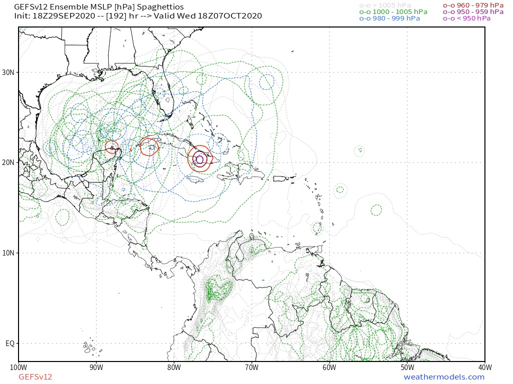
The GFS-Para within 150 hrs seems to show the best-case scenario for Gamma’s development: the precursor disturbance is just a little further north and just a little slower, and gets its act tougher a little quicker, that it has just enough time to rapidly intensify before exiting the Caribbean. That burst of intensification also appears to draw Gamma north and keep it from burying into the middle of the Yucatán.
0 likes
Irene '11 Sandy '12 Hermine '16 5/15/2018 Derecho Fay '20 Isaias '20 Elsa '21 Henri '21 Ida '21
I am only a meteorology enthusiast who knows a decent amount about tropical cyclones. Look to the professional mets, the NHC, or your local weather office for the best information.
I am only a meteorology enthusiast who knows a decent amount about tropical cyclones. Look to the professional mets, the NHC, or your local weather office for the best information.
-
gatorcane

- S2K Supporter

- Posts: 23708
- Age: 48
- Joined: Sun Mar 13, 2005 3:54 pm
- Location: Boca Raton, FL
Re: Possible development in Western Caribbean
The GFS-P finally gave in and shows what the GFS and Euro have been insisting and that is into the Yucatan and generally weak. I think the GFS-P needs more tweaking before it can replace the current GFS.
Last edited by gatorcane on Tue Sep 29, 2020 3:32 pm, edited 1 time in total.
0 likes
-
Loveweather12
- Tropical Storm

- Posts: 136
- Joined: Thu Aug 20, 2020 2:37 pm
Re: Possible development in Western Caribbean
Things could change. Something about that track isn’t right. Would wait to see an actual center form before leading people to think they don’t need to watch it or that the season is over.
gatorcane wrote:The GFS-P finally gave in and shows what the GFS and Euro have been insisting and that is into the Yucatan. I think the GFS-P needs more tweaking before it can replace the current GFS.
0 likes
-
Loveweather12
- Tropical Storm
- Posts: 136
- Joined: Thu Aug 20, 2020 2:37 pm
Re: Possible development in Western Caribbean
The GFS isn’t the brightest either.
gatorcane wrote:The GFS-P finally gave in and shows what the GFS and Euro have been insisting and that is into the Yucatan and generally weak. I think the GFS-P needs more tweaking before it can replace the current GFS.
0 likes
-
AutoPenalti
- Category 5

- Posts: 4091
- Age: 29
- Joined: Mon Aug 17, 2015 4:16 pm
- Location: Ft. Lauderdale, Florida
Re: Possible development in Western Caribbean
gatorcane wrote:The GFS-P finally gave in and shows what the GFS and Euro have been insisting and that is into the Yucatan and generally weak. I think the GFS-P needs more tweaking before it can replace the current GFS.
Nah, I think all models need tweaking, especially with what we gone through.
2 likes
The posts in this forum are NOT official forecasts and should not be used as such. They are just the opinion of the poster and may or may not be backed by sound meteorological data. They are NOT endorsed by any professional institution or STORM2K. For official information, please refer to products from the NHC and NWS.
Model Runs Cheat Sheet:
GFS (5:30 AM/PM, 11:30 AM/PM)
HWRF, GFDL, UKMET, NAVGEM (6:30-8:00 AM/PM, 12:30-2:00 AM/PM)
ECMWF (1:45 AM/PM)
TCVN is a weighted averaged

Re: Possible development in Western Caribbean
Loveweather12 wrote:So you’re saying not to watch this storm anymore?boca wrote:Our luck continues and going against climatology I’ll stay here and watch all the storms miss the peninsula in the safe zone.The panhandle is not under the deflector shield.
You know guys, sometimes I wonder if this "FL shield" is a result of the models taking the last 14 years into consideration for possibly calculating a track based on recent clinatology? Perhaps the fact is that all the misses South FL has seen since 2006, somehow screw with the models' forecast tracks, leading to such funny outcomes, hence the peninsular FL shield
0 likes
Georges '98, Irene '99, Frances '04, Jeanne '04, Katrina '05, Wilma '05, Gustav '08, Isaac '12, Matthew '16, Florence '18, Michael '18, Ian '22
-
toad strangler

- S2K Supporter
- Posts: 4546
- Joined: Sun Jul 28, 2013 3:09 pm
- Location: Earth
- Contact:
Re: Possible development in Western Caribbean
After seeing the Para go as far west as the Yucatan this morning I knew it was caving. So we sit and wait for what really happens 
0 likes
My Weather Station
https://www.wunderground.com/dashboard/pws/KFLPORTS603
https://www.wunderground.com/dashboard/pws/KFLPORTS603

Re: Possible development in Western Caribbean
FireRat wrote:Loveweather12 wrote:So you’re saying not to watch this storm anymore?boca wrote:Our luck continues and going against climatology I’ll stay here and watch all the storms miss the peninsula in the safe zone.The panhandle is not under the deflector shield.
You know guys, sometimes I wonder if this "FL shield" is a result of the models taking the last 14 years into consideration for possibly calculating a track based on recent clinatology? Perhaps the fact is that all the misses South FL has seen since 2006, somehow screw with the models' forecast tracks, leading to such funny outcomes, hence the peninsular FL shield
If only the global models had a direct consideration for climatology
The apparent "shield" is just observational, a coincidence of the steering currents over the past 15 years. Late season troughs haven't been progressive enough to bring WCarib storms to South Florida, and peak season ridging hasn't fallen in the 'goldilocks zone' to carry an intense storm north of the Caribbean but south of the Carolinas. A good stroke of luck!
4 likes
Kendall -> SLO -> PBC
Memorable Storms: Katrina (for its Florida landfall...) Wilma Matthew Irma
Memorable Storms: Katrina (for its Florida landfall...) Wilma Matthew Irma
-
toad strangler
- S2K Supporter
- Posts: 4546
- Joined: Sun Jul 28, 2013 3:09 pm
- Location: Earth
- Contact:
Re: Possible development in Western Caribbean
Ubuntwo wrote:FireRat wrote:Loveweather12 wrote:So you’re saying not to watch this storm anymore?
You know guys, sometimes I wonder if this "FL shield" is a result of the models taking the last 14 years into consideration for possibly calculating a track based on recent clinatology? Perhaps the fact is that all the misses South FL has seen since 2006, somehow screw with the models' forecast tracks, leading to such funny outcomes, hence the peninsular FL shield
If only the global models had a direct consideration for climatology
The apparent "shield" is just observational, a coincidence of the steering currents over the past 15 years. Late season troughs haven't been progressive enough to bring WCarib storms to South Florida, and peak season ridging hasn't fallen in the 'goldilocks zone' to carry an intense storm north of the Caribbean but south of the Carolinas. A good stroke of luck!
This. If one does a little research, you will find multiple long duration "breaks" since 1851 ... and really, Irma kinda broke that streak already anyway. Issue is she hit in WESTERN SOUTH FL
4 likes
My Weather Station
https://www.wunderground.com/dashboard/pws/KFLPORTS603
https://www.wunderground.com/dashboard/pws/KFLPORTS603
Re: Possible development in Western Caribbean
18z GFS: yet another SA/Yucatán run, but Gamma’s vorticity gets tougher a little quicker and is more defined as it nears landfall in Belize. Development could be starting as early as 48 hours.
0 likes
Irene '11 Sandy '12 Hermine '16 5/15/2018 Derecho Fay '20 Isaias '20 Elsa '21 Henri '21 Ida '21
I am only a meteorology enthusiast who knows a decent amount about tropical cyclones. Look to the professional mets, the NHC, or your local weather office for the best information.
I am only a meteorology enthusiast who knows a decent amount about tropical cyclones. Look to the professional mets, the NHC, or your local weather office for the best information.
-
TheStormExpert
Re: Possible development in Western Caribbean
I think part of the reason why models are far less enthusiastic with this area is that Marie in the Eastern Pacific is forecasted to become a major hurricane and induce shear in this region.
0 likes
-
SconnieCane
- Category 5
- Posts: 1013
- Joined: Thu Aug 02, 2018 5:29 pm
- Location: Madison, WI
Re: Possible development in Western Caribbean
TheStormExpert wrote:I think part of the reason why models are far less enthusiastic with this area is that Marie in the Eastern Pacific is forecasted to become a major hurricane and induce shear in this region.
I would think Marie would be moving far enough west to not be an issue. Atlantic TCs have coexisted in far closer proximity to one another than Marie will be to the western Caribbean in a few days (ex. Irma and Jose in 2017).
0 likes
-
AxaltaRacing24
- Category 5
- Posts: 1774
- Age: 25
- Joined: Wed Jul 27, 2016 11:14 am
- Location: Jupiter, FL
Re: Possible development in Western Caribbean
toad strangler wrote:Ubuntwo wrote:FireRat wrote:
You know guys, sometimes I wonder if this "FL shield" is a result of the models taking the last 14 years into consideration for possibly calculating a track based on recent clinatology? Perhaps the fact is that all the misses South FL has seen since 2006, somehow screw with the models' forecast tracks, leading to such funny outcomes, hence the peninsular FL shield
If only the global models had a direct consideration for climatology
The apparent "shield" is just observational, a coincidence of the steering currents over the past 15 years. Late season troughs haven't been progressive enough to bring WCarib storms to South Florida, and peak season ridging hasn't fallen in the 'goldilocks zone' to carry an intense storm north of the Caribbean but south of the Carolinas. A good stroke of luck!
This. If one does a little research, you will find multiple long duration "breaks" since 1851 ... and really, Irma kinda broke that streak already anyway. Issue is she hit in WESTERN SOUTH FL
yeah, i was about to say, didn't we just have a cat 3 hit the peninsula 3 years ago?
3 likes
Re: Possible development in Western Caribbean
AxaltaRacing24 wrote:toad strangler wrote:Ubuntwo wrote:If only the global models had a direct consideration for climatology
The apparent "shield" is just observational, a coincidence of the steering currents over the past 15 years. Late season troughs haven't been progressive enough to bring WCarib storms to South Florida, and peak season ridging hasn't fallen in the 'goldilocks zone' to carry an intense storm north of the Caribbean but south of the Carolinas. A good stroke of luck!
This. If one does a little research, you will find multiple long duration "breaks" since 1851 ... and really, Irma kinda broke that streak already anyway. Issue is she hit in WESTERN SOUTH FL
yeah, i was about to say, didn't we just have a cat 3 hit the peninsula 3 years ago?
Ah but Irma doesn’t count according to some posters because it didn’t landfall in Miami-Dade, Broward and Palm Beach
As to the disturbance models are having issues sorting out what is happening right now; something will develop there by end of week but I doubt will be a hurricane
4 likes
Re: Possible development in Western Caribbean
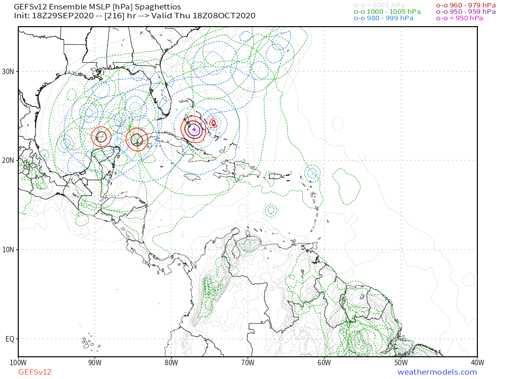
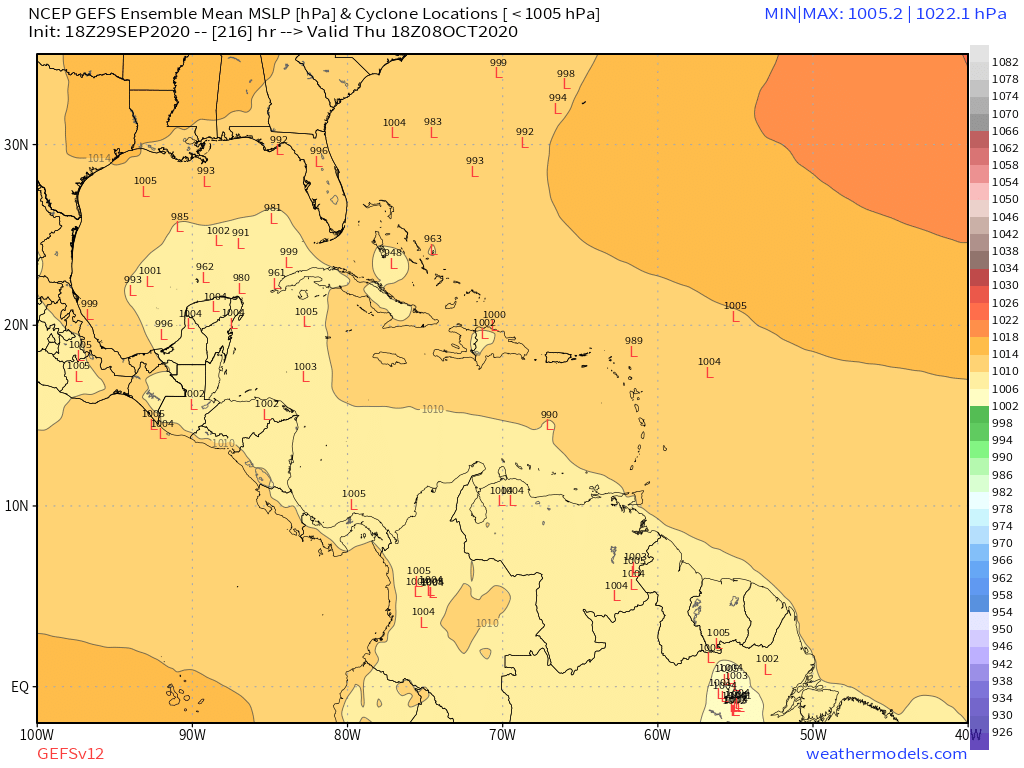
18z has this survive crossing the Yucutan Peninsula and re-intensify in the Bay of Campeche, comparable to Earl '16 or Franklin '17.


0 likes
Irene '11 Sandy '12 Hermine '16 5/15/2018 Derecho Fay '20 Isaias '20 Elsa '21 Henri '21 Ida '21
I am only a meteorology enthusiast who knows a decent amount about tropical cyclones. Look to the professional mets, the NHC, or your local weather office for the best information.
I am only a meteorology enthusiast who knows a decent amount about tropical cyclones. Look to the professional mets, the NHC, or your local weather office for the best information.
-
jlauderdal
- S2K Supporter
- Posts: 7240
- Joined: Wed May 19, 2004 5:46 am
- Location: NE Fort Lauderdale
- Contact:
Re: Possible development in Western Caribbean
It only matters if it hit SE florida..caneseddy wrote:AxaltaRacing24 wrote:toad strangler wrote:
This. If one does a little research, you will find multiple long duration "breaks" since 1851 ... and really, Irma kinda broke that streak already anyway. Issue is she hit in WESTERN SOUTH FLaway from the megalopolis. The force field is a playful hoax
yeah, i was about to say, didn't we just have a cat 3 hit the peninsula 3 years ago?
Ah but Irma doesn’t count according to some posters because it didn’t landfall in Miami-Dade, Broward and Palm Beach
As to the disturbance models are having issues sorting out what is happening right now; something will develop there by end of week but I doubt will be a hurricane

2 likes
Re: Possible development in Western Caribbean
toad strangler wrote:Ubuntwo wrote:FireRat wrote:
You know guys, sometimes I wonder if this "FL shield" is a result of the models taking the last 14 years into consideration for possibly calculating a track based on recent clinatology? Perhaps the fact is that all the misses South FL has seen since 2006, somehow screw with the models' forecast tracks, leading to such funny outcomes, hence the peninsular FL shield
If only the global models had a direct consideration for climatology
The apparent "shield" is just observational, a coincidence of the steering currents over the past 15 years. Late season troughs haven't been progressive enough to bring WCarib storms to South Florida, and peak season ridging hasn't fallen in the 'goldilocks zone' to carry an intense storm north of the Caribbean but south of the Carolinas. A good stroke of luck!
This. If one does a little research, you will find multiple long duration "breaks" since 1851 ... and really, Irma kinda broke that streak already anyway. Issue is she hit in WESTERN SOUTH FL
Yep, and SE FL isn't far past the avg return period for a major anyways. Nothing unprecedented.
OT but coastal Georgia... over 30 years past the return period for a hurricane! Lucky bunch.
2 likes
Kendall -> SLO -> PBC
Memorable Storms: Katrina (for its Florida landfall...) Wilma Matthew Irma
Memorable Storms: Katrina (for its Florida landfall...) Wilma Matthew Irma
Re: Possible development in Western Caribbean
18z GFS has this sitting in the BOC for 90 hours, becoming a 'cane for a short period. Manages to get shredded before a second landfall.
0 likes
Kendall -> SLO -> PBC
Memorable Storms: Katrina (for its Florida landfall...) Wilma Matthew Irma
Memorable Storms: Katrina (for its Florida landfall...) Wilma Matthew Irma
Re: Possible development in Western Caribbean
toad strangler wrote:Ubuntwo wrote:FireRat wrote:
You know guys, sometimes I wonder if this "FL shield" is a result of the models taking the last 14 years into consideration for possibly calculating a track based on recent clinatology? Perhaps the fact is that all the misses South FL has seen since 2006, somehow screw with the models' forecast tracks, leading to such funny outcomes, hence the peninsular FL shield
If only the global models had a direct consideration for climatology
The apparent "shield" is just observational, a coincidence of the steering currents over the past 15 years. Late season troughs haven't been progressive enough to bring WCarib storms to South Florida, and peak season ridging hasn't fallen in the 'goldilocks zone' to carry an intense storm north of the Caribbean but south of the Carolinas. A good stroke of luck!
This. If one does a little research, you will find multiple long duration "breaks" since 1851 ... and really, Irma kinda broke that streak already anyway. Issue is she hit in WESTERN SOUTH FL
Between Matthew and Dorian which both could have easily been incredibly disastrous for FL and then with Irma making landfall in the same 4 year period I think it’s safe to say the “forcefield’s” days are numbered. Not to mention Tampa Bay would easily qualify as a bad bad place to see a big storm.... possibly worse than Miami? I don’t know the topography well enough to say Tampa would be worse than Miami-Dade. The average is 15 years for a south Florida major.
0 likes

Who is online
Users browsing this forum: No registered users and 260 guests