
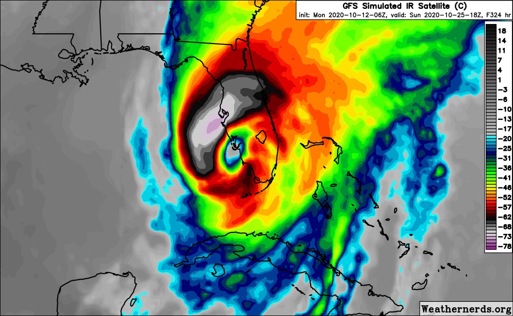
Fantasyland on 18z GFS...but its a nightmare for S Florida. This is the strongest run yet for the western Caribbean modeled low pressure.
https://www.tropicaltidbits.com/analysis/models/?model=gfs®ion=seus&pkg=mslp_pcpn&runtime=2020101118&fh=336
2020 Global Model Runs Discussion (Out thru day 16)
Moderator: S2k Moderators
Forum rules

The posts in this forum are NOT official forecasts and should not be used as such. They are just the opinion of the poster and may or may not be backed by sound meteorological data. They are NOT endorsed by any professional institution or STORM2K. For official information, please refer to products from the National Hurricane Center and National Weather Service.
-
SouthFLTropics

- Category 5

- Posts: 4258
- Age: 50
- Joined: Thu Aug 14, 2003 8:04 am
- Location: Port St. Lucie, Florida
Re: 2020 Global Model Runs Discussion (Out thru day 16)
The big question that remains and will most likely be answered in the next two weeks is whether or not South Florida has used up its 9 lives or not. Let's hope this cat still has some life in it.
0 likes
Fourth Generation Florida Native
Personal Storm History: David 79, Andrew 92, Erin 95, Floyd 99, Irene 99, Frances 04, Jeanne 04, Wilma 05, Matthew 16, Irma 17, Ian 22, Nicole 22, Milton 24
Personal Storm History: David 79, Andrew 92, Erin 95, Floyd 99, Irene 99, Frances 04, Jeanne 04, Wilma 05, Matthew 16, Irma 17, Ian 22, Nicole 22, Milton 24

Re: 2020 Global Model Runs Discussion (Out thru day 16)
GEFS stronger and more concentrated.

0 likes
The following post is NOT an official forecast and should not be used as such. It is just the opinion of the poster and may or may not be backed by sound meteorological data. It is NOT endorsed by any professional institution including storm2k.org For Official Information please refer to the NHC and NWS products.
Re: 2020 Global Model Runs Discussion (Out thru day 16)
The Happy Hour GEFS is saying that 2020 will have a good chance to be only the 3rd season on record going back to 1851 with 3 October W Caribbean geneses. The other two are 2005 (3rd one was Beta with genesis on 10/26) and 1870 (3rd one had genesis on 10/29). So, 2020 would by a good number of days have the earliest 3rd Oct W Car genesis on record:

7 likes
Personal Forecast Disclaimer:
The posts in this forum are NOT official forecasts and should not be used as such. They are just the opinion of the poster and may or may not be backed by sound meteorological data. They are NOT endorsed by any professional institution or storm2k.org. For official information, please refer to the NHC and NWS products.
The posts in this forum are NOT official forecasts and should not be used as such. They are just the opinion of the poster and may or may not be backed by sound meteorological data. They are NOT endorsed by any professional institution or storm2k.org. For official information, please refer to the NHC and NWS products.

Re: 2020 Global Model Runs Discussion (Out thru day 16)
Larry, care to make a poll lol? So this year will either remain with two Caribbean storm formation, tie the record with perhaps this long range storm threat, or even exceed and beat the record with a total of 4 (or even more?) Tropical cyclones to develop in the Caribbean this record-breaking year. My guess? I think we'll see 4 storms form in the Caribbean before it's all said & done.
0 likes
Andy D
(For official information, please refer to the NHC and NWS products.)
(For official information, please refer to the NHC and NWS products.)
Re: 2020 Global Model Runs Discussion (Out thru day 16)
chaser1 wrote:Larry, care to make a poll lol? So this year will either remain with two Caribbean storm formation, tie the record with perhaps this long range storm threat, or even exceed and beat the record with a total of 4 (or even more?) Tropical cyclones to develop in the Caribbean this record-breaking year. My guess? I think we'll see 4 storms form in the Caribbean before it's all said & done.
Chaser1,
Just to clarify, the record I'm referring to is W Caribbean (W of 75W) TS+ geneses in October. Regarding the entire Caribbean, 2005 actually has 4 since Alpha formed on 10/22/2005 in the E Caribbean. I'm nearly 100% sure that 2005's 4 is the record for the most Oct geneses in the entire Caribbean in Oct.
Are you predicting 4+ in Oct for the entire Caribbean or just for W Caribbean? I'm currently going with tieing 2005 and 1870 for the WESTERN Caribbean at 3 based on model consensus.
0 likes
Personal Forecast Disclaimer:
The posts in this forum are NOT official forecasts and should not be used as such. They are just the opinion of the poster and may or may not be backed by sound meteorological data. They are NOT endorsed by any professional institution or storm2k.org. For official information, please refer to the NHC and NWS products.
The posts in this forum are NOT official forecasts and should not be used as such. They are just the opinion of the poster and may or may not be backed by sound meteorological data. They are NOT endorsed by any professional institution or storm2k.org. For official information, please refer to the NHC and NWS products.
Re: 2020 Global Model Runs Discussion (Out thru day 16)
Meanwhile PARA says you other models have it wrong. He says ridge pushing this into CA.

0 likes
The following post is NOT an official forecast and should not be used as such. It is just the opinion of the poster and may or may not be backed by sound meteorological data. It is NOT endorsed by any professional institution including storm2k.org For Official Information please refer to the NHC and NWS products.
-
toad strangler

- S2K Supporter

- Posts: 4546
- Joined: Sun Jul 28, 2013 3:09 pm
- Location: Earth
- Contact:
Re: 2020 Global Model Runs Discussion (Out thru day 16)
blp wrote:Meanwhile PARA says you other models have it wrong. He says ridge pushing this into CA.
https://i.ibb.co/FhjW8xx/gfsp-z500a-watl-51.png
300 hours lol.... he isn’t saying anything other than a potential storm
2 likes
My Weather Station
https://www.wunderground.com/dashboard/pws/KFLPORTS603
https://www.wunderground.com/dashboard/pws/KFLPORTS603
Re: 2020 Global Model Runs Discussion (Out thru day 16)
LarryWx wrote:chaser1 wrote:Larry, care to make a poll lol? So this year will either remain with two Caribbean storm formation, tie the record with perhaps this long range storm threat, or even exceed and beat the record with a total of 4 (or even more?) Tropical cyclones to develop in the Caribbean this record-breaking year. My guess? I think we'll see 4 storms form in the Caribbean before it's all said & done.
Chaser1,
Just to clarify, the record I'm referring to is W Caribbean (W of 75W) TS+ geneses in October. Regarding the entire Caribbean, 2005 actually has 4 since Alpha formed on 10/22/2005 in the E Caribbean. I'm nearly 100% sure that 2005's 4 is the record for the most Oct geneses in the entire Caribbean in Oct.
Are you predicting 4+ in Oct for the entire Caribbean or just for W Caribbean? I'm currently going with tieing 2005 and 1870 for the WESTERN Caribbean at 3 based on model consensus.
Ahhh, understood. Up to now I hadn't really thought out east vs west genesis, but certainly do feel that there will be 4 storms forming in the Caribbean basin as a whole. Having said that, i'd be inclined to guess that all four would in fact form west of 75W.
2 likes
Andy D
(For official information, please refer to the NHC and NWS products.)
(For official information, please refer to the NHC and NWS products.)
Re: 2020 Global Model Runs Discussion (Out thru day 16)
toad strangler wrote:blp wrote:Meanwhile PARA says you other models have it wrong. He says ridge pushing this into CA.
https://i.ibb.co/FhjW8xx/gfsp-z500a-watl-51.png
300 hours lol.... he isn’t saying anything other than a potential storm
Here's what I think. Pretend there's no storm in 300 hours but let's acknowledge that we are pushing deeper into a LaNina pattern. Your choices are the following:
A) A sweeping cold front will drive through South Florida like 100,000 crazed screaming banchies OR
B) A sharp trough will drop into the Mississippi Valley within a very progressive pattern, yet the trough will then quickly and sharply pull up and out leaving Southern Georgia and Florida under the influence of warm high pressure and a WSW mid to upper level flow.
I'll place my $20 on "B". Now...... if by chance there happens to be a hurricane lurking to the south at that time??
 But hey, that's 300 hr's away so how 'bout we just sit back and check back in 100 hours from now and see what things look like then.
2 likes
Andy D
(For official information, please refer to the NHC and NWS products.)
(For official information, please refer to the NHC and NWS products.)
Re: 2020 Global Model Runs Discussion (Out thru day 16)
chaser1 wrote:toad strangler wrote:blp wrote:Meanwhile PARA says you other models have it wrong. He says ridge pushing this into CA.
https://i.ibb.co/FhjW8xx/gfsp-z500a-watl-51.png
300 hours lol.... he isn’t saying anything other than a potential storm
Here's what I think. Pretend there's no storm in 300 hours but let's acknowledge that we are pushing deeper into a LaNina pattern. Your choices are the following:
A) A sweeping cold front will drive through South Florida like 100,000 crazed screaming banchies OR
B) A sharp trough will drop into the Mississippi Valley within a very progressive pattern, yet the trough will then quickly and sharply pull up and out leaving Southern Georgia and Florida under the influence of warm high pressure and a WSW mid to upper level flow.
I'll place my $20 on "B". Now...... if by chance there happens to be a hurricane lurking to the south at that time??
Exactly, those are the two options in the models right now. That was my only point in the post which he missed... As we work closer to the end of October even throw in option c storm heading ENE through the Carribean which is still possible. October and November have the most unpredictable paths of the season.
0 likes
The following post is NOT an official forecast and should not be used as such. It is just the opinion of the poster and may or may not be backed by sound meteorological data. It is NOT endorsed by any professional institution including storm2k.org For Official Information please refer to the NHC and NWS products.
Re: 2020 Global Model Runs Discussion (Out thru day 16)
00z GFS still holds to idea the storm heading North.
CMC moves over CA. Looks like the trough is late on the CMC and allows it to move over CA.
CMC moves over CA. Looks like the trough is late on the CMC and allows it to move over CA.
0 likes
The following post is NOT an official forecast and should not be used as such. It is just the opinion of the poster and may or may not be backed by sound meteorological data. It is NOT endorsed by any professional institution including storm2k.org For Official Information please refer to the NHC and NWS products.
-
USTropics
- Professional-Met

- Posts: 2738
- Joined: Sun Aug 12, 2007 3:45 am
- Location: Florida State University
Re: 2020 Global Model Runs Discussion (Out thru day 16)
LarryWx wrote:chaser1 wrote:Larry, care to make a poll lol? So this year will either remain with two Caribbean storm formation, tie the record with perhaps this long range storm threat, or even exceed and beat the record with a total of 4 (or even more?) Tropical cyclones to develop in the Caribbean this record-breaking year. My guess? I think we'll see 4 storms form in the Caribbean before it's all said & done.
Chaser1,
Just to clarify, the record I'm referring to is W Caribbean (W of 75W) TS+ geneses in October. Regarding the entire Caribbean, 2005 actually has 4 since Alpha formed on 10/22/2005 in the E Caribbean. I'm nearly 100% sure that 2005's 4 is the record for the most Oct geneses in the entire Caribbean in Oct.
Are you predicting 4+ in Oct for the entire Caribbean or just for W Caribbean? I'm currently going with tieing 2005 and 1870 for the WESTERN Caribbean at 3 based on model consensus.
In the modern satellite era, 2005 is the only season to have experienced 4 storms in the Caribbean during October. Before this, you have to go all the way back to 1870 to see a strong case for at least 4 (possibly 5 on reanalysis):
Hurricane Six
First reported on October 5th, made landfall on October 7th in Cuba as a cat3. An estimated 1200 deaths occurred, still one of the deadliest tropical systems on record for Cuba.
Hurricane Nine
First reported in the western Caribbean on October 19th. Made landfall on October 20th in Cuba as a cat2. An estimated 52 deaths occurred.
Hurricane Ten
First reported by ship on October 23rd. While this was estimated to obtain hurricane force north of GA on the 24th, reanalysis suggests the system originated over the central Caribbean before move through the Mona Passage.
Hurricane Eleven
First reported on October 27th in the western Caribbean. Reanalysis suggests this obtained hurricane force winds before interacting with the mountainous terrain of Yucatan. It's estimated to have then headed NE towards the GOM. It was again reported on November 3rd by a passing ship as a hurricane south of Florida.
3 likes

Re: 2020 Global Model Runs Discussion (Out thru day 16)
I see the models seem to be locking on landfall or approach dates for South FL and Cuba, Oct 24 and Oct 25. This is quite interesting, because 10/24 happens to be the anniversary of Wilma in South FL and 10/25 the anniversary of the Tampa Hurricane of 1921. These dates have been historically big ones for FL during the late October time frame, and here we might go again.
It will be interesting to see if the models keep locking onto those two dates as the big dates to watch, as we get closer and closer to that time frame.
It will be interesting to see if the models keep locking onto those two dates as the big dates to watch, as we get closer and closer to that time frame.
0 likes
Georges '98, Irene '99, Frances '04, Jeanne '04, Katrina '05, Wilma '05, Gustav '08, Isaac '12, Matthew '16, Florence '18, Michael '18, Ian '22
Re: 2020 Global Model Runs Discussion (Out thru day 16)
blp wrote:chaser1 wrote:toad strangler wrote:
300 hours lol.... he isn’t saying anything other than a potential storm
Here's what I think. Pretend there's no storm in 300 hours but let's acknowledge that we are pushing deeper into a LaNina pattern. Your choices are the following:
A) A sweeping cold front will drive through South Florida like 100,000 crazed screaming banchies OR
B) A sharp trough will drop into the Mississippi Valley within a very progressive pattern, yet the trough will then quickly and sharply pull up and out leaving Southern Georgia and Florida under the influence of warm high pressure and a WSW mid to upper level flow.
I'll place my $20 on "B". Now...... if by chance there happens to be a hurricane lurking to the south at that time??
Exactly, those are the two options in the models right now. That was my only point in the post which he missed... As we work closer to the end of October even throw in option c storm heading ENE through the Carribean which is still possible. October and November have the most unpredictable paths of the season.
Boy is THAT a fact! Late season storms can be very squirrely!
2 likes
Andy D
(For official information, please refer to the NHC and NWS products.)
(For official information, please refer to the NHC and NWS products.)
-
SouthFLTropics
- Category 5
- Posts: 4258
- Age: 50
- Joined: Thu Aug 14, 2003 8:04 am
- Location: Port St. Lucie, Florida
Re: 2020 Global Model Runs Discussion (Out thru day 16)
Oh boy... This 06z GFS is not going to end well. 

2 likes
Fourth Generation Florida Native
Personal Storm History: David 79, Andrew 92, Erin 95, Floyd 99, Irene 99, Frances 04, Jeanne 04, Wilma 05, Matthew 16, Irma 17, Ian 22, Nicole 22, Milton 24
Personal Storm History: David 79, Andrew 92, Erin 95, Floyd 99, Irene 99, Frances 04, Jeanne 04, Wilma 05, Matthew 16, Irma 17, Ian 22, Nicole 22, Milton 24
-
chris_fit

- Category 5
- Posts: 3261
- Age: 43
- Joined: Wed Sep 10, 2003 11:58 pm
- Location: Tampa Bay Area, FL
Re: 2020 Global Model Runs Discussion (Out thru day 16)
SouthFLTropics wrote:Oh boy... This 06z GFS is not going to end well.
https://i.imgur.com/RMfe8sp.gif
Indeed. Having said that, this is EXACTLY where you want to be 300+ hours out

Last edited by chris_fit on Mon Oct 12, 2020 5:56 am, edited 1 time in total.
2 likes
-
SouthFLTropics
- Category 5
- Posts: 4258
- Age: 50
- Joined: Thu Aug 14, 2003 8:04 am
- Location: Port St. Lucie, Florida
Re: 2020 Global Model Runs Discussion (Out thru day 16)
Shades of Charley and Wilma

2 likes
Fourth Generation Florida Native
Personal Storm History: David 79, Andrew 92, Erin 95, Floyd 99, Irene 99, Frances 04, Jeanne 04, Wilma 05, Matthew 16, Irma 17, Ian 22, Nicole 22, Milton 24
Personal Storm History: David 79, Andrew 92, Erin 95, Floyd 99, Irene 99, Frances 04, Jeanne 04, Wilma 05, Matthew 16, Irma 17, Ian 22, Nicole 22, Milton 24
-
SFLcane

- S2K Supporter
- Posts: 10281
- Age: 48
- Joined: Sat Jun 05, 2010 1:44 pm
- Location: Lake Worth Florida
Re: 2020 Global Model Runs Discussion (Out thru day 16)
As wxman57 mentioned and there is your Wilma 2.0 possibility.
3 days before my 43 birthday what a present.
3 days before my 43 birthday what a present.
3 likes
-
SconnieCane
- Category 5
- Posts: 1013
- Joined: Thu Aug 02, 2018 5:29 pm
- Location: Madison, WI
Re: 2020 Global Model Runs Discussion (Out thru day 16)
chris_fit wrote:SouthFLTropics wrote:Oh boy... This 06z GFS is not going to end well.
https://i.imgur.com/RMfe8sp.gif
Indeed. Having said that, this is EXACTLY where you want to be 300+ hours out
https://i.imgur.com/839OC70.png
Signs of genesis are ~210 hours out, very likely this storm is not a phantom. However ultimate track and intensity still very much up in the air.
0 likes
Who is online
Users browsing this forum: No registered users and 290 guests