2020 WPAC Season

This is the general tropical discussion area. Anyone can take their shot at predicting a storms path.

Moderator: S2k Moderators

Forum rules

The posts in this forum are NOT official forecasts and should not be used as such. They are just the opinion of the poster and may or may not be backed by sound meteorological data. They are NOT endorsed by any professional institution or STORM2K. For official information, please refer to products from the National Hurricane Center and National Weather Service.

Help Support Storm2K
Message
Author
User avatar
Hayabusa
Category 5
Category 5
Posts: 4349
Joined: Sun Sep 16, 2018 1:05 pm

Re: 2020 WPAC Season

#521 Postby Hayabusa » Mon Oct 19, 2020 7:31 pm

Weather Dude wrote:
euro6208 wrote:Even stronger on the 12z EURO.

https://i.imgur.com/NRjrY7C.png

964mb is pretty significant for a Euro run

It's 960 mb actually thanks to the the hi-res version the ECMWF provides, if you saw my posts above, really I've been making and posting these plots and yet... :roll:
Image
1 likes   
ヤンデレ女が寝取られるているのを見たい!!!
ECMWF ensemble NWPAC plots: https://ecmwfensnwpac.imgbb.com/
Multimodel NWPAC plots: https://multimodelnwpac.imgbb.com/
GFS Ensemble NWPAC plots (16 & 35 day forecast): https://gefsnwpac.imgbb.com/
Plots updated automatically

User avatar
ElectricStorm
Category 5
Category 5
Posts: 5044
Age: 24
Joined: Tue Aug 13, 2019 11:23 pm
Location: Skiatook, OK / Norman, OK

Re: 2020 WPAC Season

#522 Postby ElectricStorm » Tue Oct 20, 2020 12:00 am

Pretty wacky 0z GFS run. Following behind Saudel and 97W, its got what appears to be a short-lived TD spin up, impact the Marianas, then dissipate. After that its got a broad system spin up, landfall in central Philippines before stalling for several days in the SCS while bottoming out at 978mb. Meanwhile, the long-tracker struggles to develop and hits the Marianas as a TD/TS before peaking at 986mb as it recurves. Looks like the reason it recurves could be that system stalling in the SCS. Messy run with several other weak lows that can't get going out there.
0 likes   
B.S Meteorology, University of Oklahoma '25

Please refer to the NHC, NWS, or SPC for official information.

euro6208

Re: 2020 WPAC Season

#523 Postby euro6208 » Tue Oct 20, 2020 7:49 am

How many is that?

Image
0 likes   

User avatar
mrbagyo
Category 5
Category 5
Posts: 3715
Age: 33
Joined: Thu Apr 12, 2012 9:18 am
Location: 14.13N 120.98E
Contact:

Re: 2020 WPAC Season

#524 Postby mrbagyo » Tue Oct 20, 2020 8:12 am

Image
Image
0 likes   
The posts in this forum are NOT official forecast and should not be used as such. They are just the opinion of the poster and may or may not be backed by sound meteorological data. They are NOT endorsed by any professional institution or storm2k.org. For official information, please refer to RSMC, NHC and NWS products.

euro6208

Re: 2020 WPAC Season

#525 Postby euro6208 » Tue Oct 20, 2020 8:48 am

FireRat wrote:Late October and November can produce fearsome monsters in this side of the world. Could 2020 be such a year? It will be very interesting to track the WPAC since it has been relatively quiet in this region most of the season. 2010 & 2013 come to mind.


2013 wasn't a la nina year unfortunately although it produce an incredible 5 cat 4 and 3 cat 5.
Last edited by euro6208 on Wed Oct 21, 2020 8:40 am, edited 1 time in total.
0 likes   

euro6208

Re: 2020 WPAC Season

#526 Postby euro6208 » Tue Oct 20, 2020 8:54 am

Even the strongest La nina's cannot damper the WPAC.

2010 produce 20 TC which is the LOWEST EVER in recorded history.

1998 produce 27 TC's.

1975 with 25 TC's.

All 3 years occurred during a strong nina.

1983 in a weak la nina produce 25 TC's.

Other Nina years include 2007 which produce 27 TC's.

2016 produce 32 TC's.

1970 produce 27 TC's

1995 produce 35 TC's

1984 produce 30 TC's.

2017 with a monster 33 TC's.
Last edited by euro6208 on Wed Oct 21, 2020 12:18 am, edited 4 times in total.
0 likes   

User avatar
Hayabusa
Category 5
Category 5
Posts: 4349
Joined: Sun Sep 16, 2018 1:05 pm

Re: 2020 WPAC Season

#527 Postby Hayabusa » Tue Oct 20, 2020 9:07 am


Looks like the one next to watch within 5 days is the area around 140E, another close to landmass
Image

Not sure if this is the same area JMA is mentioning.
WWJP27 RJTD 200600
WARNING AND SUMMARY 200600.
WARNING VALID 210600.
WARNING IS UPDATED EVERY 6 HOURS.
LOW PRESSURE AREA 1006 HPA NEAR 07N 146E WEST SLOWLY.
2 likes   
ヤンデレ女が寝取られるているのを見たい!!!
ECMWF ensemble NWPAC plots: https://ecmwfensnwpac.imgbb.com/
Multimodel NWPAC plots: https://multimodelnwpac.imgbb.com/
GFS Ensemble NWPAC plots (16 & 35 day forecast): https://gefsnwpac.imgbb.com/
Plots updated automatically

euro6208

Re: 2020 WPAC Season

#528 Postby euro6208 » Tue Oct 20, 2020 9:48 am

euro6208 wrote:Even the strongest La nina's cannot damper the WPAC.

2010 produce 20 TC which is the LOWEST EVER in recorded history.

1998 produce 27 TC's.

1975 with 25 TC's.

All 3 years occurred during a strong nina.

1983 in a weak la nina produce 25 TC's.

Other Nina years include 2007 which produce 27 TC's.

2016 produce 32 TC's.

1970 produce 27 TC's

1995 produce 35 TC's

1984 produce 30 TC's.

2017 with a monster 33 TC's.


This season is already at 19 with more potentially on the way.
Last edited by euro6208 on Wed Oct 21, 2020 12:24 am, edited 2 times in total.
0 likes   

euro6208

Re: 2020 WPAC Season

#529 Postby euro6208 » Tue Oct 20, 2020 7:03 pm

Image

If the MJO does propagate eastward as fast as some ensemble members suggest, increased tropical cyclone (TC) activity over the East Pacific and Caribbean is more likely during late October. However, if the intraseasonal signal is slow to propagate, continued TC activity is anticipated over the West Pacific.

Following Saudel, the GEFS continues to favor the development of another area of low pressure in the Philippine Sea late in week-1. The ECWMF ensemble mean, however, is relatively more delayed with this development, increasing TC formation potential by early week-2, while also depicting increasing signals for TC formation farther west in the South China Sea likely tied to Rossby wave activity in the region. To address the uncertainties with timing and location, a moderate confidence area is added over the Philippine Sea during week-1, and a broader moderate confidence area is posted to cover these areas during week-2.
0 likes   

User avatar
mrbagyo
Category 5
Category 5
Posts: 3715
Age: 33
Joined: Thu Apr 12, 2012 9:18 am
Location: 14.13N 120.98E
Contact:

Re: 2020 WPAC Season

#530 Postby mrbagyo » Tue Oct 20, 2020 11:41 pm

Image
0 likes   
The posts in this forum are NOT official forecast and should not be used as such. They are just the opinion of the poster and may or may not be backed by sound meteorological data. They are NOT endorsed by any professional institution or storm2k.org. For official information, please refer to RSMC, NHC and NWS products.

euro6208

Re: 2020 WPAC Season

#531 Postby euro6208 » Wed Oct 21, 2020 6:25 am

Image
Image

EURO develops the next system southwest of Guam and landfalls in central Philippines.
0 likes   

euro6208

Re: 2020 WPAC Season

#532 Postby euro6208 » Wed Oct 21, 2020 6:45 am

GFS has trended weaker with this. Only shows 1000 mb at landfall.
0 likes   

euro6208

Re: 2020 WPAC Season

#533 Postby euro6208 » Wed Oct 21, 2020 6:48 am

My goodness. GFS is all over the place.

12z

Image

18z

Image

00z

Image

Latest 06z run

Image
0 likes   

euro6208

Re: 2020 WPAC Season

#534 Postby euro6208 » Wed Oct 21, 2020 8:17 am

I think what's more startling than a global slowness in ACE despite the Atlantic producing 27 TC's is how slow the WPAC has been.
Models are incredibly in agreement on some type of burst and a few incredibly powerful typhoons with literally untapped waters in the Philippine Sea, most prone to the strongest TC's and Cat 5's, in the world.
0 likes   

euro6208

Re: 2020 WPAC Season

#535 Postby euro6208 » Wed Oct 21, 2020 9:56 am

98W thread

Up for next Philippine system.
0 likes   

al78
Professional-Met
Professional-Met
Posts: 332
Joined: Thu Nov 01, 2018 12:20 pm

Re: 2020 WPAC Season

#536 Postby al78 » Wed Oct 21, 2020 12:25 pm

euro6208 wrote:Even the strongest La nina's cannot damper the WPAC.

2010 produce 20 TC which is the LOWEST EVER in recorded history.

1998 produce 27 TC's.

1975 with 25 TC's.

All 3 years occurred during a strong nina.

1983 in a weak la nina produce 25 TC's.

Other Nina years include 2007 which produce 27 TC's.

2016 produce 32 TC's.

1970 produce 27 TC's

1995 produce 35 TC's

1984 produce 30 TC's.

2017 with a monster 33 TC's.


La Nina clearly did dampen the NWP in most of those years. 2010 was one of the lowest ACE years on record. 1998 ACE was barely over half the long term average, and 1999 was even lower. 1975, 1983, 2007, and 2017 were all well below average ACE, and 2016 was 10% below average, 1984, a bit less than 10% below average. Only 1970 on that list would be classed as near average ACE. Storm numbers in isolation is not a good metric for activity. La Nina --> below average ACE across the whole Pacific, not just the NW PAcific.
0 likes   

al78
Professional-Met
Professional-Met
Posts: 332
Joined: Thu Nov 01, 2018 12:20 pm

Re: 2020 WPAC Season

#537 Postby al78 » Wed Oct 21, 2020 12:32 pm

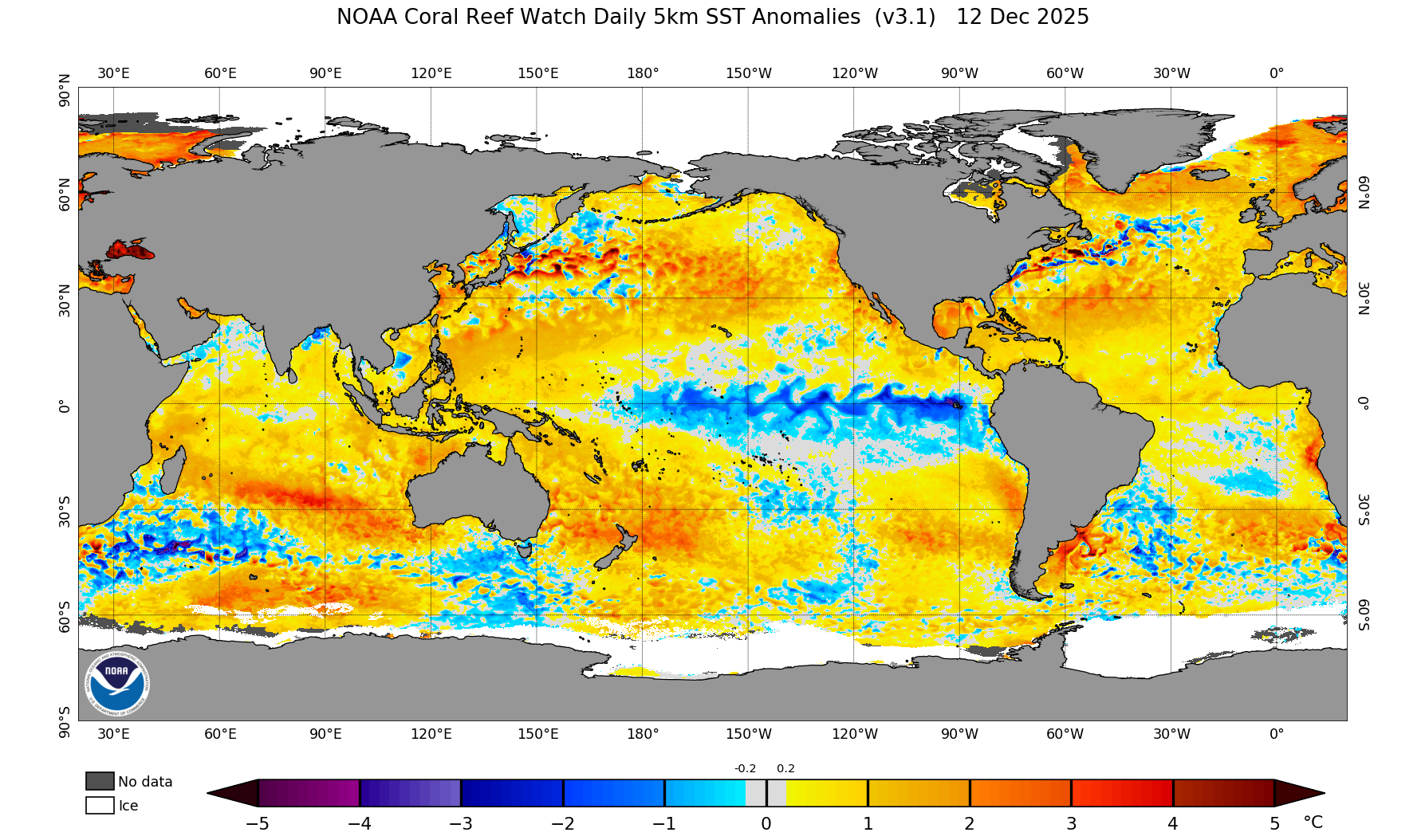
euro6208 wrote:I think what's more startling than a global slowness in ACE despite the Atlantic producing 27 TC's is how slow the WPAC has been.


Not that surprising that both the NWP and NEP have been well below normal when you look at the sea surface temperature anomalies. Huge swathe of significant negative SST anomalies in the central equatorial Pacific, with above normal temperatures near the Philippines/SCS, classic dipole which perturbs the Walker circulation generating easterly trade wind anomalies over the NW Pacific basin, leading to anticyclonic vorticity anomalies where typhoons form i.e. unfavourable.

Image
0 likes   

euro6208

Re: 2020 WPAC Season

#538 Postby euro6208 » Wed Oct 21, 2020 6:35 pm

al78 wrote:
euro6208 wrote:Even the strongest La nina's cannot damper the WPAC.

2010 produce 20 TC which is the LOWEST EVER in recorded history.

1998 produce 27 TC's.

1975 with 25 TC's.

All 3 years occurred during a strong nina.

1983 in a weak la nina produce 25 TC's.

Other Nina years include 2007 which produce 27 TC's.

2016 produce 32 TC's.

1970 produce 27 TC's

1995 produce 35 TC's

1984 produce 30 TC's.

2017 with a monster 33 TC's.


La Nina clearly did dampen the NWP in most of those years. 2010 was one of the lowest ACE years on record. 1998 ACE was barely over half the long term average, and 1999 was even lower. 1975, 1983, 2007, and 2017 were all well below average ACE, and 2016 was 10% below average, 1984, a bit less than 10% below average. Only 1970 on that list would be classed as near average ACE. Storm numbers in isolation is not a good metric for activity. La Nina --> below average ACE across the whole Pacific, not just the NW PAcific.


Yes i agree with you on ACE being the sole metric to determine how active a season is but my post was purely about storm numbers. Thanks for those stats though. :D
Last edited by euro6208 on Wed Oct 21, 2020 7:58 pm, edited 2 times in total.
0 likes   

euro6208

Re: 2020 WPAC Season

#539 Postby euro6208 » Wed Oct 21, 2020 6:44 pm

Past 2 runs of GFS shows triplets with the first one developing on Sunday/Monday as an active trough located at 10N is embedded with several weak circulations that will boost disturbances.

12z

Image

18z

Image
Last edited by euro6208 on Wed Oct 21, 2020 6:53 pm, edited 1 time in total.
0 likes   

euro6208

Re: 2020 WPAC Season

#540 Postby euro6208 » Wed Oct 21, 2020 6:49 pm

Some showers early this morning, by noon they should push to the
north of the forecast zones. The only major change to the forecast
is addition of scattered showers Sunday and Monday. This is due to
a circulation forming and moving either through or just south and
west of the Marianas. The GFS, ECMWF-HiRes, and Canadian Ensemble all
have this feature. And, if the Canadian Ensemble has it, that means
that a majority of the members have it. We`ve been dodging them all
year, we`ll have to see if we can dodge this one too. Not that it
would matter all that much, it should just be a rain bag still, with
little in the way of winds developing. After this, we should settle
down into a regular wet season pattern.
0 likes   


Return to “Talkin' Tropics”

Who is online

Users browsing this forum: Google Adsense [Bot], SconnieCane and 26 guests