
2021 EPAC Season
Moderator: S2k Moderators
Forum rules

The posts in this forum are NOT official forecasts and should not be used as such. They are just the opinion of the poster and may or may not be backed by sound meteorological data. They are NOT endorsed by any professional institution or STORM2K. For official information, please refer to products from the National Hurricane Center and National Weather Service.
-
Yellow Evan

- Professional-Met

- Posts: 16240
- Age: 27
- Joined: Fri Jul 15, 2011 12:48 pm
- Location: Henderson, Nevada/Honolulu, HI
- Contact:
-
Kingarabian

- S2K Supporter

- Posts: 16366
- Joined: Sat Aug 08, 2009 3:06 am
- Location: Honolulu, Hawaii
Re: 2021 EPAC Season
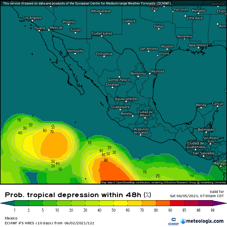
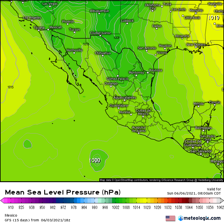
18z GFS:


Models getting bullish on a TC developing in 5 days.
UKMET which has been very conservative so far is also showing it:
12z EPS:

http://www.weathermodels.com
Models getting bullish on a TC developing in 5 days.
UKMET which has been very conservative so far is also showing it:
NEW TROPICAL CYCLONE FORECAST TO DEVELOP AFTER 120 HOURS
FORECAST POSITION AT T+120 : 13.8N 108.0W
LEAD CENTRAL MAXIMUM WIND
VERIFYING TIME TIME POSITION PRESSURE (MB) SPEED (KNOTS)
-------------- ---- -------- ------------- -------------
1200UTC 07.06.2021 120 13.8N 108.0W 1006 21
0000UTC 08.06.2021 132 13.8N 109.5W 1004 24
1200UTC 08.06.2021 144 13.9N 111.1W 1007 20
12z EPS:
http://www.weathermodels.com
0 likes
RIP Kobe Bryant
-
Yellow Evan
- Professional-Met
- Posts: 16240
- Age: 27
- Joined: Fri Jul 15, 2011 12:48 pm
- Location: Henderson, Nevada/Honolulu, HI
- Contact:


-
Kingarabian
- S2K Supporter
- Posts: 16366
- Joined: Sat Aug 08, 2009 3:06 am
- Location: Honolulu, Hawaii

-
cycloneye

- Admin

- Posts: 149505
- Age: 69
- Joined: Thu Oct 10, 2002 10:54 am
- Location: San Juan, Puerto Rico
Re: 2021 EPAC Season
A broad area of low pressure is expected to form several hundred
miles offshore of the southwestern coast of Mexico by this weekend.
Some gradual development of this system is possible thereafter as it
moves slowly westward through early next week.
* Formation chance through 48 hours...low...near 0 percent.
* Formation chance through 5 days...low...20 percent.
miles offshore of the southwestern coast of Mexico by this weekend.
Some gradual development of this system is possible thereafter as it
moves slowly westward through early next week.
* Formation chance through 48 hours...low...near 0 percent.
* Formation chance through 5 days...low...20 percent.
0 likes
Visit the Caribbean-Central America Weather Thread where you can find at first post web cams,radars
and observations from Caribbean basin members Click Here
and observations from Caribbean basin members Click Here
-
Yellow Evan
- Professional-Met
- Posts: 16240
- Age: 27
- Joined: Fri Jul 15, 2011 12:48 pm
- Location: Henderson, Nevada/Honolulu, HI
- Contact:


-
Yellow Evan
- Professional-Met
- Posts: 16240
- Age: 27
- Joined: Fri Jul 15, 2011 12:48 pm
- Location: Henderson, Nevada/Honolulu, HI
- Contact:

-
Kingarabian
- S2K Supporter
- Posts: 16366
- Joined: Sat Aug 08, 2009 3:06 am
- Location: Honolulu, Hawaii
Re: 2021 EPAC Season
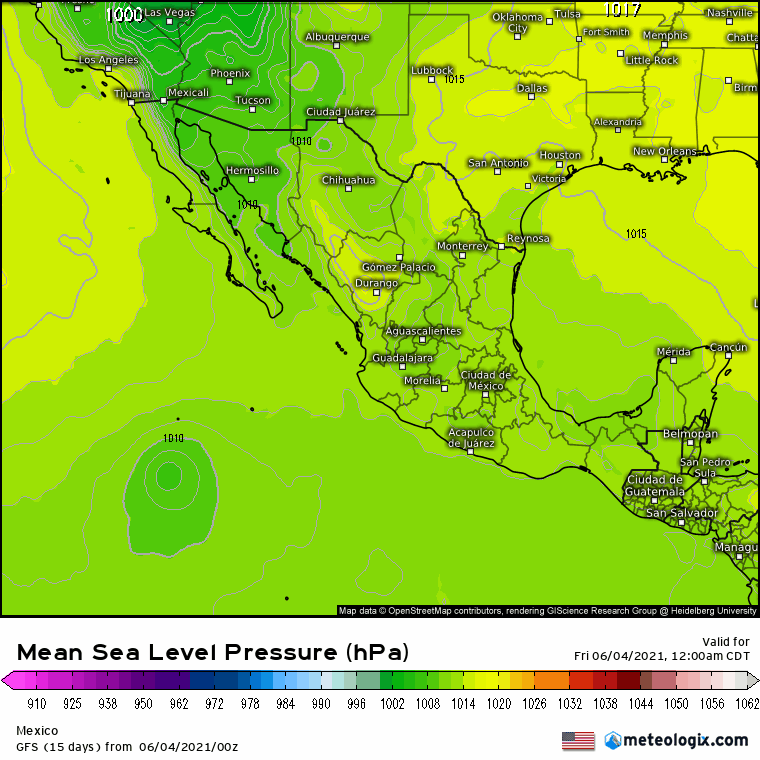
12z GFS and Euro continuing to show the 0/20 system. 12z Euro showing a deeper vort this run in the EPAC from the CAG.
0 likes
RIP Kobe Bryant
-
Yellow Evan
- Professional-Met
- Posts: 16240
- Age: 27
- Joined: Fri Jul 15, 2011 12:48 pm
- Location: Henderson, Nevada/Honolulu, HI
- Contact:

-
Nancy Smar

- Category 5

- Posts: 1081
- Age: 25
- Joined: Wed Aug 16, 2017 10:03 pm
Re: 2021 EPAC Season
GENESIS005, EP, E, , , , , 75, 2021, DB, O, 2021060300, 9999999999, , 005, , , , GENESIS, , EP752021
cycloneye wrote:A broad area of low pressure is expected to form several hundred
miles offshore of the southwestern coast of Mexico by this weekend.
Some gradual development of this system is possible thereafter as it
moves slowly westward through early next week.
* Formation chance through 48 hours...low...near 0 percent.
* Formation chance through 5 days...low...20 percent.
0 likes
-
JW-_-
Re: 2021 EPAC Season
EC sees another chance for a ts.
GFS 18z was seeing it forming roughly around the 6th.
0 likes
-
cycloneye
- Admin
- Posts: 149505
- Age: 69
- Joined: Thu Oct 10, 2002 10:54 am
- Location: San Juan, Puerto Rico
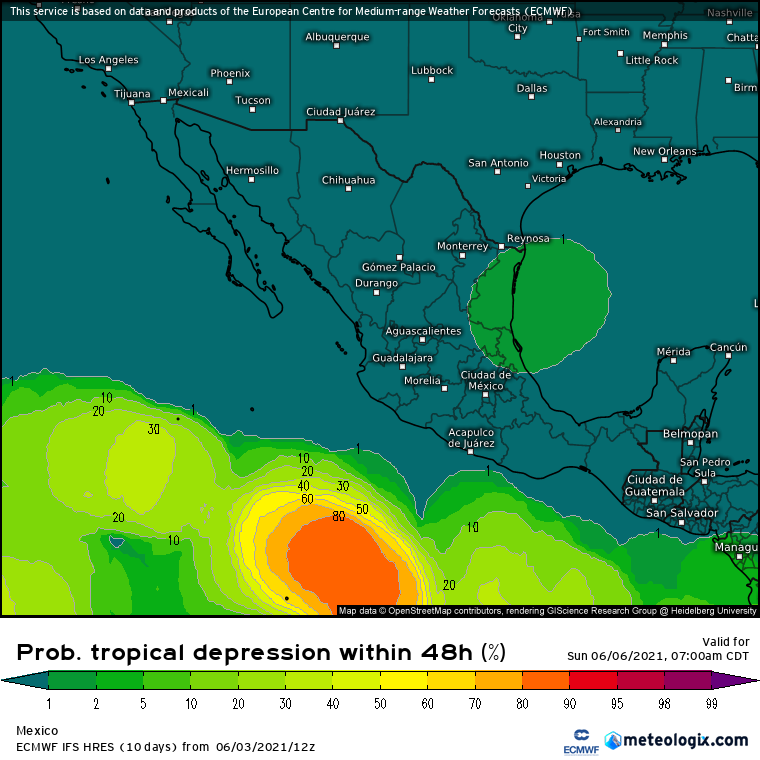
Re: 2021 EPAC Season
A trough of low pressure is producing disorganized showers and
thunderstorms several hundred miles south of Manzanillo, Mexico.
Gradual development of this system is possible during the next
several days while it drifts west-northwestward well off the coast
of Mexico.
* Formation chance through 48 hours...low...10 percent.
* Formation chance through 5 days...low...30 percent.
0 likes
Visit the Caribbean-Central America Weather Thread where you can find at first post web cams,radars
and observations from Caribbean basin members Click Here
and observations from Caribbean basin members Click Here
-
Yellow Evan
- Professional-Met
- Posts: 16240
- Age: 27
- Joined: Fri Jul 15, 2011 12:48 pm
- Location: Henderson, Nevada/Honolulu, HI
- Contact:


-
JW-_-
Re: 2021 EPAC Season
Waiting to see what the next bom run does. In my neck of the woods, we regard it better than
the USA global model.
0 likes
-
Yellow Evan
- Professional-Met
- Posts: 16240
- Age: 27
- Joined: Fri Jul 15, 2011 12:48 pm
- Location: Henderson, Nevada/Honolulu, HI
- Contact:


-
Yellow Evan
- Professional-Met
- Posts: 16240
- Age: 27
- Joined: Fri Jul 15, 2011 12:48 pm
- Location: Henderson, Nevada/Honolulu, HI
- Contact:
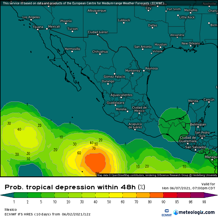
Re: 2021 EPAC Season
A trough of low pressure is producing disorganized showers and
thunderstorms several hundred miles south of Manzanillo, Mexico.
Gradual development of this system is possible during the next
several days, and a tropical depression could form late this weekend
or early next week while it drifts west-northwestward well off the
coast of Mexico.
* Formation chance through 48 hours...low...10 percent.
* Formation chance through 5 days...medium...40 percent.
0 likes
-
Yellow Evan
- Professional-Met
- Posts: 16240
- Age: 27
- Joined: Fri Jul 15, 2011 12:48 pm
- Location: Henderson, Nevada/Honolulu, HI
- Contact:


Who is online
Users browsing this forum: Kingarabian, ljmac75, Ntxw, Ulf, USTropics and 259 guests