http://twitter.com/drrickknabb/status/1423777331626323969
2021 Indicators: SST's / SAL / MSLP / Shear / Steering / Instability / Sat Images
Moderator: S2k Moderators
Forum rules

The posts in this forum are NOT official forecasts and should not be used as such. They are just the opinion of the poster and may or may not be backed by sound meteorological data. They are NOT endorsed by any professional institution or STORM2K. For official information, please refer to products from the National Hurricane Center and National Weather Service.
-
toad strangler

- S2K Supporter

- Posts: 4546
- Joined: Sun Jul 28, 2013 3:09 pm
- Location: Earth
- Contact:
-
AlphaToOmega
- Category 5

- Posts: 1448
- Joined: Sat Jun 26, 2021 10:51 am
- Location: Somewhere in Massachusetts
Re: 2021 Indicators: SST's / SAL / MSLP / Shear / Steering / Instability / Sat Images
I would like to bring up 2010 as an analog year. Before August 20, only three storms formed: Alex, Bonnie, and Colin. Ultimately, 19 storms formed in 2010. 2010 seems like a pretty good analog year for 2021 based on the SST and VP patterns. So far, five storms formed in 2021, and a few more could form in the coming days. 2010 was actually stunted by a significant amount of dry air. If that were not there, it might have rivalled 2005 and 2020. There will be very little dry air in the Atlantic come August 20, and the SST and VP patterns are forecasted to be very similar to that of 2010. Based on this, I believe 2021 has a shot at rivalling 2020, 2005, and 1933 in terms of activity. I am not saying 2021 will definitely rival 2020, 2005, and 1933; such an event is incredibly rare for a reason. I am just pointing out the possibility.
Last edited by AlphaToOmega on Sat Aug 07, 2021 6:46 am, edited 1 time in total.
0 likes

Re: 2021 Indicators: SST's / SAL / MSLP / Shear / Steering / Instability / Sat Images
AlphaToOmega wrote:I would like to bring up 2010 as an analog year. Before August 20, only three storms formed: Alex, Bonnie, and Colin. Ultimately, 19 storms formed in 2010. 2010 seems like a pretty good analog year for 2021 based on the SST and VP patterns. So far, five storms formed in 2021, and a few more could form in the coming days. 2010 was actually stunted by a significant amount of dry air. If that were not there, it might have rivalled 2005 and 2020. There were be very little dry air in the Atlantic come August 20, and the SST and VP patterns are forecasted to be very similar to that of 2010. Based on this, I believe 2021 has a shot at rivalling 2020, 2005, and 1933 in terms of activity. I am not saying 2021 will definitely rival 2020, 2005, and 1933; such an event is incredibly rare for a reason. I am just pointing out the possibility.
I highly doubt 2021 will rival 1933/2005 — it has not been nearly consistently active enough — but I do agree with the 2010 analogy. Lots of weak struggle storms between the anomaly that was Hurricane Alex in June/July and Hurricane Danielle on August 23rd, and then it went nuts with 8 storms in September and 5 in October/November. It’s impossible to predict how many storms 2021 will have between mid-August and the end of September, but even just having 2 in the rest of August followed by 6 in September and 2 in the rest of the year would bring the total up to 15 NS.
Still, it’s kinda baffling the Atlantic is struggling this hard while the EPac is popping out storms like rabbits. 2010 had the opposite situation: barely any activity at all.
0 likes
Irene '11 Sandy '12 Hermine '16 5/15/2018 Derecho Fay '20 Isaias '20 Elsa '21 Henri '21 Ida '21
I am only a meteorology enthusiast who knows a decent amount about tropical cyclones. Look to the professional mets, the NHC, or your local weather office for the best information.
I am only a meteorology enthusiast who knows a decent amount about tropical cyclones. Look to the professional mets, the NHC, or your local weather office for the best information.
-
Category5Kaiju

- Category 5
- Posts: 4336
- Joined: Thu Dec 24, 2020 12:45 pm
- Location: Seattle during the summer, Phoenix during the winter
Re: 2021 Indicators: SST's / SAL / MSLP / Shear / Steering / Instability / Sat Images
aspen wrote:AlphaToOmega wrote:I would like to bring up 2010 as an analog year. Before August 20, only three storms formed: Alex, Bonnie, and Colin. Ultimately, 19 storms formed in 2010. 2010 seems like a pretty good analog year for 2021 based on the SST and VP patterns. So far, five storms formed in 2021, and a few more could form in the coming days. 2010 was actually stunted by a significant amount of dry air. If that were not there, it might have rivalled 2005 and 2020. There were be very little dry air in the Atlantic come August 20, and the SST and VP patterns are forecasted to be very similar to that of 2010. Based on this, I believe 2021 has a shot at rivalling 2020, 2005, and 1933 in terms of activity. I am not saying 2021 will definitely rival 2020, 2005, and 1933; such an event is incredibly rare for a reason. I am just pointing out the possibility.
I highly doubt 2021 will rival 1933/2005 — it has not been nearly consistently active enough — but I do agree with the 2010 analogy. Lots of weak struggle storms between the anomaly that was Hurricane Alex in June/July and Hurricane Danielle on August 23rd, and then it went nuts with 8 storms in September and 5 in October/November. It’s impossible to predict how many storms 2021 will have between mid-August and the end of September, but even just having 2 in the rest of August followed by 6 in September and 2 in the rest of the year would bring the total up to 15 NS.
Still, it’s kinda baffling the Atlantic is struggling this hard while the EPac is popping out storms like rabbits. 2010 had the opposite situation: barely any activity at all.
What's even weirder is that the EPAC, while popping storms out like rabbits, has really not seen very quality storms; by this time of the year the EPAC in recent years regardless of ENSO state has typically seen at least 2 major hurricanes, but this year aside from Felicia it has really not been at its greatest of its abilities. This is why I still think there's a very tangible limitation on the EPAC activity given the ENSO state and why I think the Atlantic will take over soon. Now while I don't expect a mind boggling 240+ ACE year like 2005 or 1933, I still think at worst case scenario we could still see a 150+ ACE year.
2 likes
Unless explicitly stated, all information in my posts is based on my own opinions and observations. Tropical storms and hurricanes can be extremely dangerous. Refer to an accredited weather research agency or meteorologist if you need to make serious decisions regarding an approaching storm.
-
cycloneye

- Admin

- Posts: 149523
- Age: 69
- Joined: Thu Oct 10, 2002 10:54 am
- Location: San Juan, Puerto Rico
Re: 2021 Indicators: SST's / SAL / MSLP / Shear / Steering / Instability / Sat Images
0 likes
Visit the Caribbean-Central America Weather Thread where you can find at first post web cams,radars
and observations from Caribbean basin members Click Here
and observations from Caribbean basin members Click Here
-
AlphaToOmega
- Category 5
- Posts: 1448
- Joined: Sat Jun 26, 2021 10:51 am
- Location: Somewhere in Massachusetts
Re: 2021 Indicators: SST's / SAL / MSLP / Shear / Steering / Instability / Sat Images
Category5Kaiju wrote:aspen wrote:AlphaToOmega wrote:I would like to bring up 2010 as an analog year. Before August 20, only three storms formed: Alex, Bonnie, and Colin. Ultimately, 19 storms formed in 2010. 2010 seems like a pretty good analog year for 2021 based on the SST and VP patterns. So far, five storms formed in 2021, and a few more could form in the coming days. 2010 was actually stunted by a significant amount of dry air. If that were not there, it might have rivalled 2005 and 2020. There were be very little dry air in the Atlantic come August 20, and the SST and VP patterns are forecasted to be very similar to that of 2010. Based on this, I believe 2021 has a shot at rivalling 2020, 2005, and 1933 in terms of activity. I am not saying 2021 will definitely rival 2020, 2005, and 1933; such an event is incredibly rare for a reason. I am just pointing out the possibility.
I highly doubt 2021 will rival 1933/2005 — it has not been nearly consistently active enough — but I do agree with the 2010 analogy. Lots of weak struggle storms between the anomaly that was Hurricane Alex in June/July and Hurricane Danielle on August 23rd, and then it went nuts with 8 storms in September and 5 in October/November. It’s impossible to predict how many storms 2021 will have between mid-August and the end of September, but even just having 2 in the rest of August followed by 6 in September and 2 in the rest of the year would bring the total up to 15 NS.
Still, it’s kinda baffling the Atlantic is struggling this hard while the EPac is popping out storms like rabbits. 2010 had the opposite situation: barely any activity at all.
What's even weirder is that the EPAC, while popping storms out like rabbits, has really not seen very quality storms; by this time of the year the EPAC in recent years regardless of ENSO state has typically seen at least 2 major hurricanes, but this year aside from Felicia it has really not been at its greatest of its abilities. This is why I still think there's a very tangible limitation on the EPAC activity given the ENSO state and why I think the Atlantic will take over soon. Now while I don't expect a mind boggling 240+ ACE year like 2005 or 1933, I still think at worst case scenario we could still see a 150+ ACE year.
Many La Nina years have incredibly front-loaded Pacific hurricane seasons. This was seen in 1998, 2008, 2010, 2016, and 2017; what we are seeing now is normal for La Nina years. Early season East/Central Pacific activity is not a bellwether for overall Pacific hurricane activity. This surge of activity is just a result of an MJO phase, which I have been preaching for a while now. In fact, MJO can explain a lot of things.
4 likes
-
Yellow Evan

- Professional-Met

- Posts: 16241
- Age: 27
- Joined: Fri Jul 15, 2011 12:48 pm
- Location: Henderson, Nevada/Honolulu, HI
- Contact:
Re: 2021 Indicators: SST's / SAL / MSLP / Shear / Steering / Instability / Sat Images
It’s highly unlikely to. As I’ve said repeatedly, this is a longstanding issue with the GFS that seems to have gotten worse ever since the African Standing Wave became dominant around around 2017-19. He even acknowledges such as well:
https://twitter.com/derekortt/status/1423789713631105027
https://twitter.com/derekortt/status/1423792783731613698
Last edited by Yellow Evan on Fri Aug 06, 2021 7:27 pm, edited 1 time in total.
6 likes
-
toad strangler
- S2K Supporter
- Posts: 4546
- Joined: Sun Jul 28, 2013 3:09 pm
- Location: Earth
- Contact:
Re: 2021 Indicators: SST's / SAL / MSLP / Shear / Steering / Instability / Sat Images
384 hours
PLUS we already got 1983 beat by one storm haha
0 likes
My Weather Station
https://www.wunderground.com/dashboard/pws/KFLPORTS603
https://www.wunderground.com/dashboard/pws/KFLPORTS603
-
Category5Kaiju
- Category 5
- Posts: 4336
- Joined: Thu Dec 24, 2020 12:45 pm
- Location: Seattle during the summer, Phoenix during the winter
Re: 2021 Indicators: SST's / SAL / MSLP / Shear / Steering / Instability / Sat Images
Now I will also say this as I feel it is a very important point to understand, but I think there's a very prevalent attitude around the wx community that this lull is very surprising; however, let's say you switched Bill, Claudette, and Danny as occurring in July and Elsa in June instead. That's still a healthy start to a season; it just so happened that June ended up being the most active June recorded and that it just feels like with the dissipation of Elsa that high activity levels have not occurred for a while (making this lull seemingly longer and more unusual than it really is).
0 likes
Unless explicitly stated, all information in my posts is based on my own opinions and observations. Tropical storms and hurricanes can be extremely dangerous. Refer to an accredited weather research agency or meteorologist if you need to make serious decisions regarding an approaching storm.
-
Category5Kaiju
- Category 5
- Posts: 4336
- Joined: Thu Dec 24, 2020 12:45 pm
- Location: Seattle during the summer, Phoenix during the winter
Re: 2021 Indicators: SST's / SAL / MSLP / Shear / Steering / Instability / Sat Images
Yellow Evan wrote:
It’s highly unlikely to. As I’ve said repeatedly, this is a longstanding issue with the GFS that seems to have gotten worse ever since the African Standing Wave became dominant around around 2017-19. He even acknowledges such as well:
https://twitter.com/derekortt/status/1423789713631105027?s=21
https://twitter.com/derekortt/status/1423792783731613698?s=21
Derek Ortt is such an amusing and informative hurricane Tweeter.
Oh, and don't forget this part of the thread, I think it really explains what we've been seeing with the GFS constantly blowing up storms as if we were in 1983 again
https://twitter.com/WxTca/status/1423794277893689350
0 likes
Unless explicitly stated, all information in my posts is based on my own opinions and observations. Tropical storms and hurricanes can be extremely dangerous. Refer to an accredited weather research agency or meteorologist if you need to make serious decisions regarding an approaching storm.
-
gatorcane

- S2K Supporter
- Posts: 23708
- Age: 48
- Joined: Sun Mar 13, 2005 3:54 pm
- Location: Boca Raton, FL
Re: 2021 Indicators: SST's / SAL / MSLP / Shear / Steering / Instability / Sat Images
Category5Kaiju wrote:Yellow Evan wrote:
It’s highly unlikely to. As I’ve said repeatedly, this is a longstanding issue with the GFS that seems to have gotten worse ever since the African Standing Wave became dominant around around 2017-19. He even acknowledges such as well:
https://twitter.com/derekortt/status/1423789713631105027?s=21
https://twitter.com/derekortt/status/1423792783731613698?s=21
Derek Ortt is such an amusing and informative hurricane Tweeter.
Oh, and don't forget this part of the thread, I think it really explains what we've been seeing with the GFS constantly blowing up storms as if we were in 1983 again
https://twitter.com/WxTca/status/1423794277893689350
Last year the GFS showed similar hostile conditions across the Atlantic in the long-range around this time with one storm after the other blowing up in the EPAC, we know what happened after that.
4 likes
-
Category5Kaiju
- Category 5
- Posts: 4336
- Joined: Thu Dec 24, 2020 12:45 pm
- Location: Seattle during the summer, Phoenix during the winter
Re: 2021 Indicators: SST's / SAL / MSLP / Shear / Steering / Instability / Sat Images
To be fair, I really think that us just coming out of a record-smashing 30 NS season is one of the underlying reasons why I think there are some individuals who are not very optimistic about this season. With last year producing NSs incessantly and 12 US NS landfalls while this year seeing a long lull so far, I think it's naturally tempting to believe that this year is not going to be as active and impactful. However, if you compare 2021 with other very active years such as 1950, 1961, 1995, 1996, 2004, 2010, and 2017, based on where we are NS-wise at least, we are waiting for the 6th NS, which typically would be expected to occur in mid-August. In other words, where we are currently NS-wise is not anything abnormal. If the factors for an above average season are to hold, then we could easily achieve at least 18 NSs by the end of the season imho (given CSU's 18 NS forecast), and that would still make 2021 at least within the top 5 most active years. In short, I think it's important to understand that for very active years, what we saw in 2005 and 2020 with more than 25 NSs (let alone a very active July) is not something you should expect to happen extremely frequently, and even with 18-20 or so NSs, 2021 could still end up as a historically active year, at least NS-wise.
5 likes
Unless explicitly stated, all information in my posts is based on my own opinions and observations. Tropical storms and hurricanes can be extremely dangerous. Refer to an accredited weather research agency or meteorologist if you need to make serious decisions regarding an approaching storm.
-
AtlanticWind

- S2K Supporter
- Posts: 1898
- Age: 67
- Joined: Sun Aug 08, 2004 9:57 pm
- Location: Plantation,Fla
Re: 2021 Indicators: SST's / SAL / MSLP / Shear / Steering / Instability / Sat Images
Its only August 6th and a lot of talk already about 2021 being kind of a bust.
Seems to me its a result of too much model watching. Its interesting to look past 5 days in the models
but I think we all sometimes put too much weight in longer range model runs.
I expect the lid will come off at some point in next 2 to 4 weeks.
Seems to me its a result of too much model watching. Its interesting to look past 5 days in the models
but I think we all sometimes put too much weight in longer range model runs.
I expect the lid will come off at some point in next 2 to 4 weeks.
7 likes

Re: 2021 Indicators: SST's / SAL / MSLP / Shear / Steering / Instability / Sat Images
AtlanticWind wrote:Its only August 6th and a lot of talk already about 2021 being kind of a bust.
Seems to me its a result of too much model watching. Its interesting to look past 5 days in the models
but I think we all sometimes put too much weight in longer range model runs.
I expect the lid will come off at some point in next 2 to 4 weeks.
People seem to have a short term memory with this.
Even this year, Elsa wasn't showing up in most runs until less than five days out. After last year and what happened with Laura, I've realized the models are pretty much useless as far as genesis beyond 72 hours.
8 likes
The above post is not official and should not be used as such. It is the opinion of the poster and may or may not be backed by sound meteorological data. It is not endorsed by any professional institution or storm2k.org. For official information, please refer to the NHC and NWS products.
-
storminabox
- Category 1

- Posts: 263
- Joined: Sun Jul 09, 2017 10:50 pm
Re: 2021 Indicators: SST's / SAL / MSLP / Shear / Steering / Instability / Sat Images
aspen wrote:AlphaToOmega wrote:I would like to bring up 2010 as an analog year. Before August 20, only three storms formed: Alex, Bonnie, and Colin. Ultimately, 19 storms formed in 2010. 2010 seems like a pretty good analog year for 2021 based on the SST and VP patterns. So far, five storms formed in 2021, and a few more could form in the coming days. 2010 was actually stunted by a significant amount of dry air. If that were not there, it might have rivalled 2005 and 2020. There were be very little dry air in the Atlantic come August 20, and the SST and VP patterns are forecasted to be very similar to that of 2010. Based on this, I believe 2021 has a shot at rivalling 2020, 2005, and 1933 in terms of activity. I am not saying 2021 will definitely rival 2020, 2005, and 1933; such an event is incredibly rare for a reason. I am just pointing out the possibility.
I highly doubt 2021 will rival 1933/2005 — it has not been nearly consistently active enough — but I do agree with the 2010 analogy. Lots of weak struggle storms between the anomaly that was Hurricane Alex in June/July and Hurricane Danielle on August 23rd, and then it went nuts with 8 storms in September and 5 in October/November. It’s impossible to predict how many storms 2021 will have between mid-August and the end of September, but even just having 2 in the rest of August followed by 6 in September and 2 in the rest of the year would bring the total up to 15 NS.
Still, it’s kinda baffling the Atlantic is struggling this hard while the EPac is popping out storms like rabbits. 2010 had the opposite situation: barely any activity at all.
Yet all of the EPAC storms have been slop — similar in a lot of ways to 2017/2019.
1 likes
-
Shell Mound
- Category 5
- Posts: 2432
- Age: 33
- Joined: Thu Sep 07, 2017 3:39 pm
- Location: St. Petersburg, FL → Scandinavia
Re: 2021 Indicators: SST's / SAL / MSLP / Shear / Steering / Instability / Sat Images
2 likes
CVW / MiamiensisWx / Shell Mound
The posts in this forum are NOT official forecasts and should not be used as such. They are just the opinion of the poster and may or may not be backed by sound meteorological data. They are NOT endorsed by any professional institution or STORM2K. For official information, please refer to products from the NHC and NWS.
-
AlphaToOmega
- Category 5
- Posts: 1448
- Joined: Sat Jun 26, 2021 10:51 am
- Location: Somewhere in Massachusetts
Re: 2021 Indicators: SST's / SAL / MSLP / Shear / Steering / Instability / Sat Images
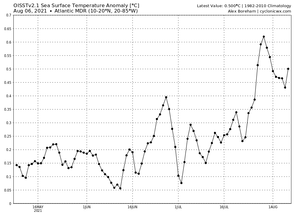
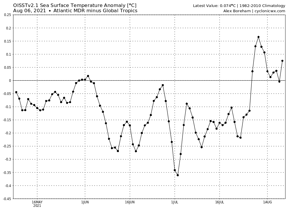
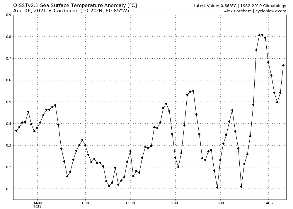
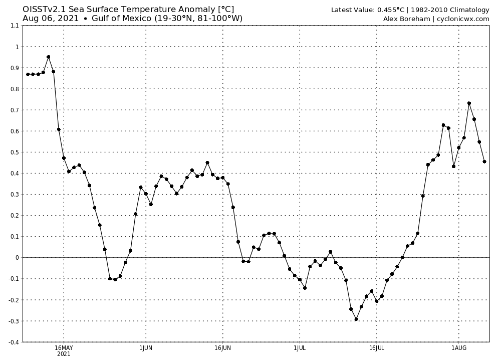

The Atlantic Main Development Region is relatively warmer than both the global tropics and the Atlantic subtropics. The Caribbean and Gulf of Mexico are both above-average in terms of sea surface temperatures.
4 likes
-
AlphaToOmega
- Category 5
- Posts: 1448
- Joined: Sat Jun 26, 2021 10:51 am
- Location: Somewhere in Massachusetts
Re: 2021 Indicators: SST's / SAL / MSLP / Shear / Steering / Instability / Sat Images
The monsoon trough in the Atlantic is creating a large area of enhanced convection, and the waves could develop once they reach the Western Atlantic, just like in 2020.
"Just like in 2020" is a phrase you do not want to hear in any context, not just weather.
"Just like in 2020" is a phrase you do not want to hear in any context, not just weather.
1 likes
-
Category5Kaiju
- Category 5
- Posts: 4336
- Joined: Thu Dec 24, 2020 12:45 pm
- Location: Seattle during the summer, Phoenix during the winter
Re: 2021 Indicators: SST's / SAL / MSLP / Shear / Steering / Instability / Sat Images
https://twitter.com/iCyclone/status/1423576997645766661
So here’s a recent tweet from the legendary epic hurricane chaser Josh Morgerman, and his comment imho reflects an even broader but notable to understand issue: the WPAC at this point in time is definitely not performing at its best, generating many weak storms (with the same that can be said for the EPAC at least so far). The fact that both basins are not doing very hot now in terms of quality storms makes me want to believe that we’re going to see the Atlantic take over soon as the dominant basin
So here’s a recent tweet from the legendary epic hurricane chaser Josh Morgerman, and his comment imho reflects an even broader but notable to understand issue: the WPAC at this point in time is definitely not performing at its best, generating many weak storms (with the same that can be said for the EPAC at least so far). The fact that both basins are not doing very hot now in terms of quality storms makes me want to believe that we’re going to see the Atlantic take over soon as the dominant basin
6 likes
Unless explicitly stated, all information in my posts is based on my own opinions and observations. Tropical storms and hurricanes can be extremely dangerous. Refer to an accredited weather research agency or meteorologist if you need to make serious decisions regarding an approaching storm.
Re: 2021 Indicators: SST's / SAL / MSLP / Shear / Steering / Instability / Sat Images
So far the first half of August is doing what it tends to do...behaving as July's 3rd half.
1 likes
Who is online
Users browsing this forum: No registered users and 202 guests