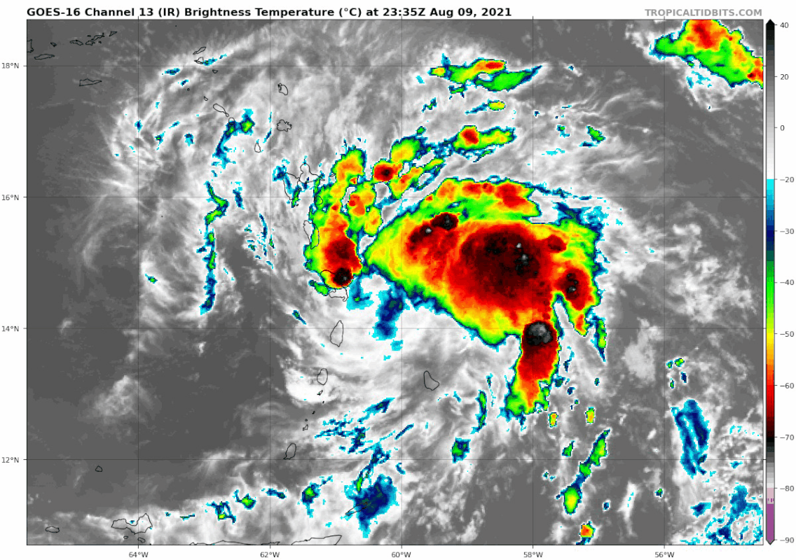
This is one of weirdest looking PTCS I've ever seen. Convection looks fairly decent with the banding (and improving) in the northern section of the potential cyclone and the south is just completely devoid of any convection...also looks to me like the center is going due west for right now and has just passed over Martinque. Lets if it can fight off the dry air
ATL: FRED - Post-Tropical - Discussion
Moderator: S2k Moderators
-
Stormybajan

- Category 1

- Posts: 453
- Joined: Thu May 20, 2021 3:21 pm
- Location: Windward Islands
Re: ATL: SIX - Potential Tropical Cyclone - Discussion
This is one of weirdest looking PTCS I've ever seen. Convection looks fairly decent with the banding (and improving) in the northern section of the potential cyclone and the south is just completely devoid of any convection...also looks to me like the center is going due west for right now and has just passed over Martinque. Lets if it can fight off the dry air
0 likes
Sad West Indies and Manchester United fan ⚽️
-
tropicwatch

- Category 5

- Posts: 3426
- Age: 62
- Joined: Sat Jun 02, 2007 10:01 am
- Location: The Villages, Florida
- Contact:
Re: ATL: SIX - Potential Tropical Cyclone - Discussion
chaser1 wrote:Despite much of the convection shunted a bit north and east, it appears to me that the LLC continues to become better defined. Another observation is that the present term motion of the COC appears practically due west. Finally, banding features are far more impressive then 24 hr's ago.
The circulation appears more concentrated and looks like a decent outflow has started.
3 likes
Tropicwatch
Agnes 72', Eloise 75, Elena 85', Kate 85', Charley 86', Florence 88', Beryl 94', Dean 95', Erin 95', Opal 95', Earl 98', Georges 98', Ivan 2004', Arlene 2005', Dennis 2005', Ida 2009' Debby 2012' Irma 2017' Michael 2018'
Agnes 72', Eloise 75, Elena 85', Kate 85', Charley 86', Florence 88', Beryl 94', Dean 95', Erin 95', Opal 95', Earl 98', Georges 98', Ivan 2004', Arlene 2005', Dennis 2005', Ida 2009' Debby 2012' Irma 2017' Michael 2018'
-
SFLcane

- S2K Supporter

- Posts: 10281
- Age: 48
- Joined: Sat Jun 05, 2010 1:44 pm
- Location: Lake Worth Florida
Re: ATL: SIX - Potential Tropical Cyclone - Discussion
From 11pm advisory.
However, the environmental conditions could become more favorable for strengthening again by the end of the week, which
is the reason why the forecast shows slightly higher wind speeds at those time periods.
However, the environmental conditions could become more favorable for strengthening again by the end of the week, which
is the reason why the forecast shows slightly higher wind speeds at those time periods.
4 likes
-
toad strangler

- S2K Supporter
- Posts: 4546
- Joined: Sun Jul 28, 2013 3:09 pm
- Location: Earth
- Contact:
Re: ATL: SIX - Potential Tropical Cyclone - Discussion
SFLcane wrote:From 11pm advisory.
However, the environmental conditions could become more favorable for strengthening again by the end of the week, which
is the reason why the forecast shows slightly higher wind speeds at those time periods.
11PM 5 day cone turned oh so slightly to the N & E
Last edited by toad strangler on Mon Aug 09, 2021 10:04 pm, edited 1 time in total.
0 likes
My Weather Station
https://www.wunderground.com/dashboard/pws/KFLPORTS603
https://www.wunderground.com/dashboard/pws/KFLPORTS603
-
SFLcane
- S2K Supporter
- Posts: 10281
- Age: 48
- Joined: Sat Jun 05, 2010 1:44 pm
- Location: Lake Worth Florida
Re: ATL: SIX - Potential Tropical Cyclone - Discussion
toad strangler wrote:SFLcane wrote:From 11pm advisory.
However, the environmental conditions could become more favorable for strengthening again by the end of the week, which
is the reason why the forecast shows slightly higher wind speeds at those time periods.
11PM 5 day cone turned oh so lightly to the N & E
Weakness will be there. If this relocates north or goes north of islands I would definitely go much higher in intensity.
4 likes
-
Yellow Evan

- Professional-Met

- Posts: 16242
- Age: 27
- Joined: Fri Jul 15, 2011 12:48 pm
- Location: Henderson, Nevada/Honolulu, HI
- Contact:

-
toad strangler
- S2K Supporter
- Posts: 4546
- Joined: Sun Jul 28, 2013 3:09 pm
- Location: Earth
- Contact:
Re: ATL: SIX - Potential Tropical Cyclone - Discussion
SFLcane wrote:toad strangler wrote:SFLcane wrote:From 11pm advisory.
However, the environmental conditions could become more favorable for strengthening again by the end of the week, which
is the reason why the forecast shows slightly higher wind speeds at those time periods.
11PM 5 day cone turned oh so lightly to the N & E
Weakness will be there. If this relocates north or goes north of islands I would definitely go much higher in intensity.
The only way for PTC6 to go N of Hispaniola is to hit PR head on ...
0 likes
My Weather Station
https://www.wunderground.com/dashboard/pws/KFLPORTS603
https://www.wunderground.com/dashboard/pws/KFLPORTS603
-
floridasun78
- Category 5
- Posts: 3755
- Joined: Sun May 17, 2009 10:16 pm
- Location: miami fl
Re: ATL: SIX - Potential Tropical Cyclone - Discussion
you can see dry air hitting from south side of PTC6 tonight
0 likes

Re: ATL: SIX - Potential Tropical Cyclone - Discussion
Well that’s a really annoying position for a storm to get an ASCAT pass. Much of the maximum winds were likely missed because of the islands. We’ll have to wait for recon to figure out if we have an open TD-force wave or a closed TS by tomorrow morning.
1 likes
Irene '11 Sandy '12 Hermine '16 5/15/2018 Derecho Fay '20 Isaias '20 Elsa '21 Henri '21 Ida '21
I am only a meteorology enthusiast who knows a decent amount about tropical cyclones. Look to the professional mets, the NHC, or your local weather office for the best information.
I am only a meteorology enthusiast who knows a decent amount about tropical cyclones. Look to the professional mets, the NHC, or your local weather office for the best information.

Re: ATL: SIX - Potential Tropical Cyclone - Discussion
Half the cone is in Hispaniola half is out. It also should be noted that the "shredder" parts of Hispaniola are in the Center and South. The Northern third which still features mountains rises to about 1000m a little under half in height of the Central and Southern mountains.
Puerto Rico could have a significant influence on the Storm, but probably not enough to kill it.
Sent from my SM-G988U1 using Tapatalk
Puerto Rico could have a significant influence on the Storm, but probably not enough to kill it.
Sent from my SM-G988U1 using Tapatalk
6 likes
-
IsabelaWeather
- Category 1
- Posts: 316
- Age: 36
- Joined: Tue Jul 07, 2020 7:29 am
- Location: Isabela, Puerto Rico
Re: ATL: SIX - Potential Tropical Cyclone - Discussion
toad strangler wrote:SFLcane wrote:toad strangler wrote:
11PM 5 day cone turned oh so lightly to the N & E
Weakness will be there. If this relocates north or goes north of islands I would definitely go much higher in intensity.
The only way for PTC6 to go N of Hispaniola is to hit PR head on ...
I mean, not really. It could hit anywhere in the SW corner and be ok, which would line it up to hit the north shore of the DR neither of which would hurt it much.
1 likes
Re: ATL: SIX - Potential Tropical Cyclone - Discussion
Here is a terrain map of Hispaniola from NASA that shows the various features.
Sent from my SM-G988U1 using Tapatalk
Sent from my SM-G988U1 using Tapatalk
3 likes
-
Category5Kaiju

- Category 5
- Posts: 4338
- Joined: Thu Dec 24, 2020 12:45 pm
- Location: Seattle during the summer, Phoenix during the winter
Re: ATL: SIX - Potential Tropical Cyclone - Discussion
Woofde wrote:Half the cone is in Hispaniola half is out. It also should be noted that the "shredder" parts of Hispaniola are in the Center and South. The Northern third which still features mountains rises to about 1000m a little under half in height of the Central and Southern mountains.
Puerto Rico could have a significant influence on the Storm, but probably not enough to kill it.
Sent from my SM-G988U1 using Tapatalk
This is very much a key point that should definitely be worth considering. Many people seem to think that the entire island itself is like some sort of glaring deathtrap for any storms that go near or over it, but in reality the angle of the storm strike, the linear speed of the storm, and the exact location on that island where the storm tracks over could mean the difference between an intact storm that is barely scathed versus disintegration.
4 likes
Unless explicitly stated, all information in my posts is based on my own opinions and observations. Tropical storms and hurricanes can be extremely dangerous. Refer to an accredited weather research agency or meteorologist if you need to make serious decisions regarding an approaching storm.
-
toad strangler
- S2K Supporter
- Posts: 4546
- Joined: Sun Jul 28, 2013 3:09 pm
- Location: Earth
- Contact:
Re: ATL: SIX - Potential Tropical Cyclone - Discussion
Category5Kaiju wrote:Woofde wrote:Half the cone is in Hispaniola half is out. It also should be noted that the "shredder" parts of Hispaniola are in the Center and South. The Northern third which still features mountains rises to about 1000m a little under half in height of the Central and Southern mountains.
Puerto Rico could have a significant influence on the Storm, but probably not enough to kill it.
Sent from my SM-G988U1 using Tapatalk
This is very much a key point that should definitely be worth considering. Many people seem to think that the entire island itself is like some sort of glaring deathtrap for any storms that go near or over it, but in reality the angle of the storm strike, the linear speed of the storm, and the exact location on that island where the storm tracks over could mean the difference between an intact storm that is barely scathed versus disintegration.
These are things dissected over and over again when a system dances with the Shredder Chain. These islands didn't just pop up last night out of the Caribbean
5 likes
My Weather Station
https://www.wunderground.com/dashboard/pws/KFLPORTS603
https://www.wunderground.com/dashboard/pws/KFLPORTS603
-
Blown Away

- S2K Supporter
- Posts: 10253
- Joined: Wed May 26, 2004 6:17 am
Re: ATL: SIX - Potential Tropical Cyclone - Discussion
5pm had PTC6 at 15.4N/61.4W at 2am EST...
0 likes
Hurricane Eye Experience: David 79, Irene 99, Frances 04, Jeanne 04, Wilma 05… Hurricane Brush Experience: Andrew 92, Erin 95, Floyd 99, Matthew 16, Irma 17, Ian 22, Nicole 22…
-
Hurricane Mike
- Category 2

- Posts: 675
- Joined: Tue Apr 10, 2018 7:44 am
Re: ATL: SIX - Potential Tropical Cyclone - Discussion
Here is an 11:30pm video on PTC 6
https://www.youtube.com/watch?v=1G9YCLwLDO0
https://www.youtube.com/watch?v=1G9YCLwLDO0
0 likes
Re: ATL: SIX - Potential Tropical Cyclone - Discussion
True, but the geography of Hispaniola is quite complex and it never hurts to brush up on it.toad strangler wrote:Category5Kaiju wrote:Woofde wrote:Half the cone is in Hispaniola half is out. It also should be noted that the "shredder" parts of Hispaniola are in the Center and South. The Northern third which still features mountains rises to about 1000m a little under half in height of the Central and Southern mountains.
Puerto Rico could have a significant influence on the Storm, but probably not enough to kill it.
Sent from my SM-G988U1 using Tapatalk
This is very much a key point that should definitely be worth considering. Many people seem to think that the entire island itself is like some sort of glaring deathtrap for any storms that go near or over it, but in reality the angle of the storm strike, the linear speed of the storm, and the exact location on that island where the storm tracks over could mean the difference between an intact storm that is barely scathed versus disintegration.
These are things dissected over and over again when a system dances with the Shredder Chain. These islands didn't just pop up last night out of the Caribbean
Sent from my SM-G988U1 using Tapatalk
4 likes
-
ElectricStorm

- Category 5
- Posts: 5148
- Age: 25
- Joined: Tue Aug 13, 2019 11:23 pm
- Location: Norman, OK
Re: ATL: SIX - Potential Tropical Cyclone - Discussion
If I was in S FL I would be watching this one very closely. If it follows the current NHC track, it might miss the tallest mountains and have a better chance to survive. Of course if it stays weak then the mountains may not affect it much anyway. If it gets through there and finds some favorable conditions, it might intensify pretty quickly. Personally, I think we'll be looking at a mid-TS in the Caribbean followed by an upper TS into FL. I can't rule out a Cat 1 hurricane but I think the chances of that are low for now. We'll have to see how it interacts with the islands first. If it gets through there intact then watch out. HWRF and GFS hinting at favorable conditions.
I just hope it doesn't find good conditions and strengthen quickly on approach to FL as that wouldn't give people much time to prepare for it. Again, I think the odds of that are low but I would be watching this like a hawk if I was there since it's been awhile since they've had a direct hit by any storm.
I just hope it doesn't find good conditions and strengthen quickly on approach to FL as that wouldn't give people much time to prepare for it. Again, I think the odds of that are low but I would be watching this like a hawk if I was there since it's been awhile since they've had a direct hit by any storm.
Last edited by ElectricStorm on Mon Aug 09, 2021 11:29 pm, edited 1 time in total.
3 likes
B.S Meteorology, University of Oklahoma '25
Please refer to the NHC, NWS, or SPC for official information.
Please refer to the NHC, NWS, or SPC for official information.
-
emeraldislenc
- Category 2
- Posts: 601
- Joined: Fri Aug 24, 2012 4:49 pm
- Location: Emerald Isle NC
Re: ATL: SIX - Potential Tropical Cyclone - Discussion
To be honest I get tired of hearing the word shredder to me it seems like an overkill as if a storm never made it past Haiti or the Dominican Republic. Just my two cents worth!
6 likes
-
IsabelaWeather
- Category 1
- Posts: 316
- Age: 36
- Joined: Tue Jul 07, 2020 7:29 am
- Location: Isabela, Puerto Rico
Re: ATL: SIX - Potential Tropical Cyclone - Discussion
Hmm, is that the center with the 3 new strong thunderstorms? They look like they are wrapping around a central point.

Last edited by IsabelaWeather on Mon Aug 09, 2021 11:36 pm, edited 3 times in total.
2 likes
Who is online
Users browsing this forum: No registered users and 10 guests