
All the LL clouds west of the axis are pretty much stationary now.
Should start to pull in next few hours
ATL: FRED - Post-Tropical - Discussion
Moderator: S2k Moderators
-
captainbarbossa19

- Professional-Met

- Posts: 1094
- Age: 27
- Joined: Wed Aug 21, 2019 11:09 pm
- Location: Beaumont, TX
Re: ATL: SIX - Potential Tropical Cyclone - Discussion
What amazes me is that the Eastern Caribbean Sea has been a lot more kind this season to systems passing through it. It's often very hostile to any development.
4 likes
-
tolakram
- Admin

- Posts: 20186
- Age: 62
- Joined: Sun Aug 27, 2006 8:23 pm
- Location: Florence, KY (name is Mark)
Re: ATL: SIX - Potential Tropical Cyclone - Discussion
1 likes
M a r k
- - - - -
Join us in chat: Storm2K Chatroom Invite. Android and IOS apps also available.
The posts in this forum are NOT official forecasts and should not be used as such. Posts are NOT endorsed by any professional institution or STORM2K.org. For official information and forecasts, please refer to NHC and NWS products.
-
Spacecoast

- Category 2

- Posts: 773
- Joined: Thu Aug 31, 2017 2:03 pm
Re: ATL: SIX - Potential Tropical Cyclone - Discussion
Enhanced Infrared (IR) Imagery (4 km Mercator)
(as of 19:20)


(as of 19:20)
0 likes
-
Category5Kaiju

- Category 5

- Posts: 4339
- Joined: Thu Dec 24, 2020 12:45 pm
- Location: Seattle during the summer, Phoenix during the winter
Re: ATL: SIX - Potential Tropical Cyclone - Discussion
captainbarbossa19 wrote:What amazes me is that the Eastern Caribbean Sea has been a lot more kind this season to systems passing through it. It's often very hostile to any development.
It’s not a graveyard anymore…it’s a big bottle of energy drink
2 likes
Unless explicitly stated, all information in my posts is based on my own opinions and observations. Tropical storms and hurricanes can be extremely dangerous. Refer to an accredited weather research agency or meteorologist if you need to make serious decisions regarding an approaching storm.
-
TallyTracker
- Category 2
- Posts: 787
- Joined: Thu Oct 11, 2018 2:46 pm
Re: ATL: SIX - Potential Tropical Cyclone - Discussion
It’s hard to believe looking at the satellite that this could still be a wave, but we have seen it before in this area. I believe it was Dolly in 2008 that had 55-60 mph sustained winds as a wave with excellent satellite presentation.
0 likes
Fran '96, Georges '98, Gordon '00, Gabrielle '01, Charley '04, Frances '04, Jeanne '04, Barry '07, Fay '08, Debby '12, Matthew '16, Emily '17, Irma '17, Michael ‘18, Elsa ‘21, Fred ‘21, Mindy ‘21, Nicole ‘22, Idalia ‘23, Debby ‘24, Helene ‘24

Re: ATL: SIX - Potential Tropical Cyclone - Discussion
Where is the recon when you need it the most.

0 likes

Re: ATL: SIX - Potential Tropical Cyclone - Discussion
Looks a little better than last time I checked a few hours ago. Almost seems like it has a CDO forming. Banding remains excellent.
Is recon going out again today?
Is recon going out again today?
Last edited by aspen on Tue Aug 10, 2021 2:55 pm, edited 1 time in total.
0 likes
Irene '11 Sandy '12 Hermine '16 5/15/2018 Derecho Fay '20 Isaias '20 Elsa '21 Henri '21 Ida '21
I am only a meteorology enthusiast who knows a decent amount about tropical cyclones. Look to the professional mets, the NHC, or your local weather office for the best information.
I am only a meteorology enthusiast who knows a decent amount about tropical cyclones. Look to the professional mets, the NHC, or your local weather office for the best information.

Re: ATL: SIX - Potential Tropical Cyclone - Discussion
Hot towers might be an indication we have a center all the way down to the surface now.
Might get some ship or buoy obs before this reaches southwestern Puerto Rico.
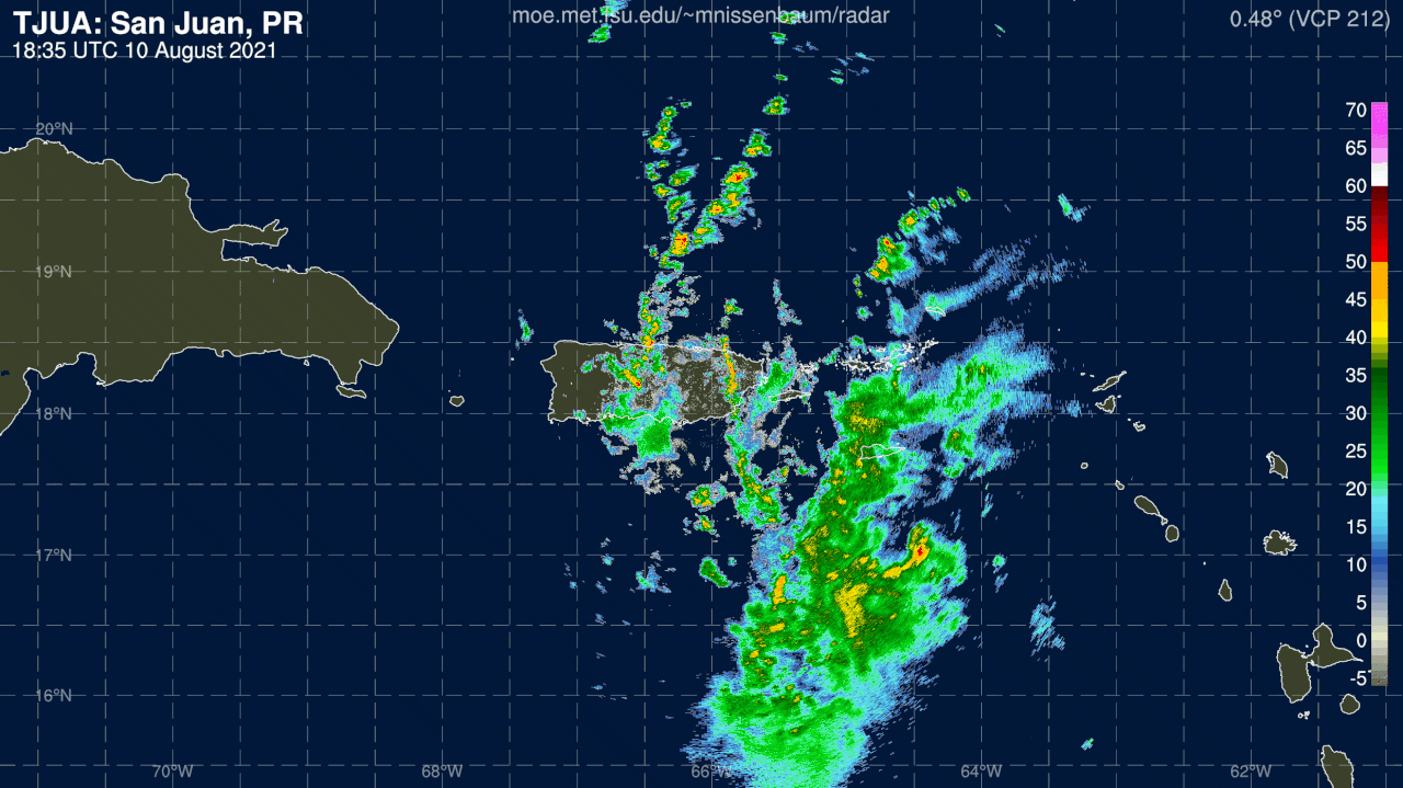
Radar is still looking at the mid levels and recon didn't find much with dropsondes right at the surface where the dry air has been undercutting the circulation up to 600 MBs.
Might get some ship or buoy obs before this reaches southwestern Puerto Rico.
Radar is still looking at the mid levels and recon didn't find much with dropsondes right at the surface where the dry air has been undercutting the circulation up to 600 MBs.
1 likes
-
Sciencerocks
- Category 5
- Posts: 10186
- Age: 40
- Joined: Thu Jul 06, 2017 1:51 am
Re: ATL: SIX - Potential Tropical Cyclone - Discussion
I have a hard time believing that this isn't closed. I expect Fred soon!

0 likes
-
AutoPenalti
- Category 5
- Posts: 4091
- Age: 29
- Joined: Mon Aug 17, 2015 4:16 pm
- Location: Ft. Lauderdale, Florida
Re: ATL: SIX - Potential Tropical Cyclone - Discussion
This is still moving due west, not sure the HWRF will verify.
0 likes
The posts in this forum are NOT official forecasts and should not be used as such. They are just the opinion of the poster and may or may not be backed by sound meteorological data. They are NOT endorsed by any professional institution or STORM2K. For official information, please refer to products from the NHC and NWS.
Model Runs Cheat Sheet:
GFS (5:30 AM/PM, 11:30 AM/PM)
HWRF, GFDL, UKMET, NAVGEM (6:30-8:00 AM/PM, 12:30-2:00 AM/PM)
ECMWF (1:45 AM/PM)
TCVN is a weighted averaged
Re: ATL: SIX - Potential Tropical Cyclone - Discussion
We are finally seeing some pressures falling in the area, St Croix.
Good indication the LLC is finally getting going.
METAR for: TISX (St Croix/Rohlsen Arp, VI, US)
Text: TISX 101953Z 09022G29KT 6SM RA BR BKN015 OVC070 26/25 A2988 RMK AO2 PK WND 09029/1944 SLP115 P0000 T02610250
Temperature: 26.1°C ( 79°F)
Dewpoint: 25.0°C ( 77°F) [RH = 94%]
Pressure (altimeter): 29.88 inches Hg (1011.9 mb) [Sea level pressure: 1011.5 mb]
Winds: from the E (90 degrees) at 25 MPH (22 knots; 11.3 m/s) gusting to 33 MPH (29 knots; 14.9 m/s)
Visibility: 6 sm ( 10 km)
Ceiling: 1500 feet AGL
Clouds: broken clouds at 1500 feet AGL, overcast cloud deck at 7000 feet AGL
Weather: RA BR (moderate rain, mist)
1 likes
-
SFLcane

- S2K Supporter

- Posts: 10281
- Age: 48
- Joined: Sat Jun 05, 2010 1:44 pm
- Location: Lake Worth Florida
Re: ATL: SIX - Potential Tropical Cyclone - Discussion
NDG wrote:We are finally seeing some pressures falling in the area, St Croix.
Good indication the LLC is finally getting going.
METAR for: TISX (St Croix/Rohlsen Arp, VI, US)
Text: TISX 101953Z 09022G29KT 6SM RA BR BKN015 OVC070 26/25 A2988 RMK AO2 PK WND 09029/1944 SLP115 P0000 T02610250
Temperature: 26.1°C ( 79°F)
Dewpoint: 25.0°C ( 77°F) [RH = 94%]
Pressure (altimeter): 29.88 inches Hg (1011.9 mb) [Sea level pressure: 1011.5 mb]
Winds: from the E (90 degrees) at 25 MPH (22 knots; 11.3 m/s) gusting to 33 MPH (29 knots; 14.9 m/s)
Visibility: 6 sm ( 10 km)
Ceiling: 1500 feet AGL
Clouds: broken clouds at 1500 feet AGL, overcast cloud deck at 7000 feet AGL
Weather: RA BR (moderate rain, mist)
Link?
0 likes
Re: ATL: SIX - Potential Tropical Cyclone - Discussion
SFLcane wrote:NDG wrote:We are finally seeing some pressures falling in the area, St Croix.
Good indication the LLC is finally getting going.
METAR for: TISX (St Croix/Rohlsen Arp, VI, US)
Text: TISX 101953Z 09022G29KT 6SM RA BR BKN015 OVC070 26/25 A2988 RMK AO2 PK WND 09029/1944 SLP115 P0000 T02610250
Temperature: 26.1°C ( 79°F)
Dewpoint: 25.0°C ( 77°F) [RH = 94%]
Pressure (altimeter): 29.88 inches Hg (1011.9 mb) [Sea level pressure: 1011.5 mb]
Winds: from the E (90 degrees) at 25 MPH (22 knots; 11.3 m/s) gusting to 33 MPH (29 knots; 14.9 m/s)
Visibility: 6 sm ( 10 km)
Ceiling: 1500 feet AGL
Clouds: broken clouds at 1500 feet AGL, overcast cloud deck at 7000 feet AGL
Weather: RA BR (moderate rain, mist)
Link?
https://www.wrh.noaa.gov/mesowest/times ... aw=0&w=325
0 likes
Re: ATL: SIX - Potential Tropical Cyclone - Discussion
AutoPenalti wrote:This is still moving due west, not sure the HWRF will verify.
h85 Vorticity has not been moving due W, over all it has been moving WNW for the past 24 hrs.
1 likes
Re: ATL: SIX - Potential Tropical Cyclone - Discussion
captainbarbossa19 wrote:What amazes me is that the Eastern Caribbean Sea has been a lot more kind this season to systems passing through it. It's often very hostile to any development.
We've seen this in storms traversing through the northeast part of the Caribbean Sea, its when they come into the sea at due west or further south where conditions are generally more unfavorable
0 likes
Andrew (1992), Irene (1999), Frances (2004), Katrina (2005), Wilma (2005), Fay (2008), Irma (2017), Eta (2020), Ian (2022)

Re: ATL: SIX - Potential Tropical Cyclone - Discussion
I’m still thinking it’s a broad elongated center near 16.4N 65.4 W with a strong MLC evident on radar rotating around that broad center for now. The shredder will rip it apart IMHO.
0 likes
The following post is NOT an official forecast and should not be used as such. It is just the opinion of the poster and may or may not be backed by sound meteorological data. It is NOT endorsed by any professional institution including storm2k.org For Official Information please refer to the NHC and NWS products.
-
SFLcane
- S2K Supporter
- Posts: 10281
- Age: 48
- Joined: Sat Jun 05, 2010 1:44 pm
- Location: Lake Worth Florida
Re: ATL: SIX - Potential Tropical Cyclone - Discussion
NDG wrote:We are finally seeing some pressures falling in the area, St Croix.
Good indication the LLC is finally getting going.
METAR for: TISX (St Croix/Rohlsen Arp, VI, US)
Text: TISX 101953Z 09022G29KT 6SM RA BR BKN015 OVC070 26/25 A2988 RMK AO2 PK WND 09029/1944 SLP115 P0000 T02610250
Temperature: 26.1°C ( 79°F)
Dewpoint: 25.0°C ( 77°F) [RH = 94%]
Pressure (altimeter): 29.88 inches Hg (1011.9 mb) [Sea level pressure: 1011.5 mb]
Winds: from the E (90 degrees) at 25 MPH (22 knots; 11.3 m/s) gusting to 33 MPH (29 knots; 14.9 m/s)
Visibility: 6 sm ( 10 km)
Ceiling: 1500 feet AGL
Clouds: broken clouds at 1500 feet AGL, overcast cloud deck at 7000 feet AGL
Weather: RA BR (moderate rain, mist)
This is indeed descent pressure falls sense recon was there.
1 likes
-
AxaltaRacing24
- Category 5
- Posts: 1774
- Age: 25
- Joined: Wed Jul 27, 2016 11:14 am
- Location: Jupiter, FL
Re: ATL: SIX - Potential Tropical Cyclone - Discussion
AutoPenalti wrote:This is still moving due west, not sure the HWRF will verify.
That’s just expansion of the CDO and outflow. but the COC itself is tracking WNW.
0 likes
Who is online
Users browsing this forum: No registered users and 45 guests