ATL: IDA - Models

Moderator: S2k Moderators

Message
Author
User avatar
Steve
S2K Supporter
S2K Supporter
Posts: 9591
Joined: Sat Apr 05, 2003 11:41 pm
Location: Not a state-caster

Re: ATL: NINE - Models

#761 Postby Steve » Thu Aug 26, 2021 12:52 pm

txwatcher91 wrote:HWRF a 942mb bomb at landfall.


Beast. A little farther west than the globals though toward St. Mary/Iberia parishes (New Iberia, Franklin, Ricohoc, Lydia, Morgan City, etc.). There are a couple hundred thousand people down that way and then a couple hundred more in the bayou just east of there (Lafourche/Terrebonne/Assumption Parishes).
0 likes   

Senobia
Category 1
Category 1
Posts: 278
Joined: Sat Aug 05, 2006 2:59 pm
Location: Somewhere over the rainbow

Re: ATL: NINE - Models

#762 Postby Senobia » Thu Aug 26, 2021 12:57 pm

captainbarbossa19 wrote:It looks like the 12z GEFS is more west than the operational GFS. Some members still show landfall as far west as the LA/TX state line.


Link? Graphic?
0 likes   

tolakram
Admin
Admin
Posts: 19990
Age: 61
Joined: Sun Aug 27, 2006 8:23 pm
Location: Florence, KY (name is Mark)

Re: ATL: NINE - Models

#763 Postby tolakram » Thu Aug 26, 2021 12:58 pm

HWRF
Image
0 likes   
M a r k
- - - - -
Join us in chat: Storm2K Chatroom Invite. Android and IOS apps also available.

The posts in this forum are NOT official forecasts and should not be used as such. Posts are NOT endorsed by any professional institution or STORM2K.org. For official information and forecasts, please refer to NHC and NWS products.

Senobia
Category 1
Category 1
Posts: 278
Joined: Sat Aug 05, 2006 2:59 pm
Location: Somewhere over the rainbow

Re: ATL: NINE - Models

#764 Postby Senobia » Thu Aug 26, 2021 12:59 pm

Steve wrote:CMC is coming in with a western component still. This is different than what usually happens and would probably indicate strengthening up until landfall or at least maintaining vs. fading northeast and getting absorbed/weakening. Looks to come in around Grand Isle/Fourchon which means everyone from Harrison County over to Terrebonne are going to get hit pretty hard <-- per the CMC.

However, CMC is fast and landfalls Sunday am. I haven't looked at ICON or GFS 12z to see if they have sped up landfall as well.


Harrison County....where?
0 likes   

tolakram
Admin
Admin
Posts: 19990
Age: 61
Joined: Sun Aug 27, 2006 8:23 pm
Location: Florence, KY (name is Mark)

Re: ATL: NINE - Models

#765 Postby tolakram » Thu Aug 26, 2021 1:01 pm

Senobia wrote:
captainbarbossa19 wrote:It looks like the 12z GEFS is more west than the operational GFS. Some members still show landfall as far west as the LA/TX state line.


Link? Graphic?


Very misleading. Those members all show consolidation south of the current position.

Image
1 likes   
M a r k
- - - - -
Join us in chat: Storm2K Chatroom Invite. Android and IOS apps also available.

The posts in this forum are NOT official forecasts and should not be used as such. Posts are NOT endorsed by any professional institution or STORM2K.org. For official information and forecasts, please refer to NHC and NWS products.

User avatar
ROCK
Category 5
Category 5
Posts: 9483
Age: 54
Joined: Tue Aug 17, 2004 7:30 am
Location: Kemah, Texas

Re: ATL: NINE - Models

#766 Postby ROCK » Thu Aug 26, 2021 1:01 pm

If the winds catch up to 944MB dude god speed LA.. :eek: :eek: .I would be road trippin it west. just my opinion of course.
1 likes   

Senobia
Category 1
Category 1
Posts: 278
Joined: Sat Aug 05, 2006 2:59 pm
Location: Somewhere over the rainbow

Re: ATL: NINE - Models

#767 Postby Senobia » Thu Aug 26, 2021 1:04 pm

tolakram wrote:
Senobia wrote:
captainbarbossa19 wrote:It looks like the 12z GEFS is more west than the operational GFS. Some members still show landfall as far west as the LA/TX state line.


Link? Graphic?


Very misleading. Those members all show consolidation south of the current position.

https://i.imgur.com/bz1DDdN.png


Thanks. That's what I thought I saw. Was just wondering there was some phenomenal W shift I had missed.
0 likes   

tolakram
Admin
Admin
Posts: 19990
Age: 61
Joined: Sun Aug 27, 2006 8:23 pm
Location: Florence, KY (name is Mark)

Re: ATL: NINE - Models

#768 Postby tolakram » Thu Aug 26, 2021 1:11 pm

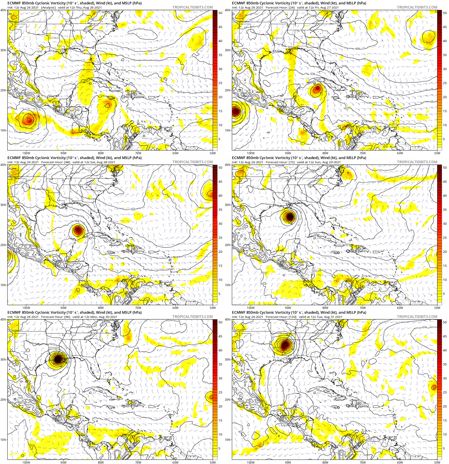
12Z Euro running
Image
0 likes   
M a r k
- - - - -
Join us in chat: Storm2K Chatroom Invite. Android and IOS apps also available.

The posts in this forum are NOT official forecasts and should not be used as such. Posts are NOT endorsed by any professional institution or STORM2K.org. For official information and forecasts, please refer to NHC and NWS products.

User avatar
Steve
S2K Supporter
S2K Supporter
Posts: 9591
Joined: Sat Apr 05, 2003 11:41 pm
Location: Not a state-caster

Re: ATL: NINE - Models

#769 Postby Steve » Thu Aug 26, 2021 1:12 pm

Senobia wrote:
Steve wrote:CMC is coming in with a western component still. This is different than what usually happens and would probably indicate strengthening up until landfall or at least maintaining vs. fading northeast and getting absorbed/weakening. Looks to come in around Grand Isle/Fourchon which means everyone from Harrison County over to Terrebonne are going to get hit pretty hard <-- per the CMC.

However, CMC is fast and landfalls Sunday am. I haven't looked at ICON or GFS 12z to see if they have sped up landfall as well.


Harrison County....where?


Coastal mostly, but pretty much the whole county. They'll be under training bands as the system pulls up just west of due north. Obviously the farther west it goes, the less the impacts over that way. But press play on these for an idea:

GFS Simulated IR4
https://www.tropicaltidbits.com/analysi ... 612&fh=222

GFS Rainfall Estimates (a foot for Harrison & Hancock Co's)
https://www.tropicaltidbits.com/analysi ... 612&fh=168

Now the CMC which is what you specifically quoted that I posted:

CMC IR4 Simulated Sattelite
https://www.tropicaltidbits.com/analysi ... 2612&fh=37
0 likes   

User avatar
SoupBone
Category 5
Category 5
Posts: 3111
Joined: Tue Sep 20, 2005 5:24 pm

Re: ATL: NINE - Models

#770 Postby SoupBone » Thu Aug 26, 2021 1:13 pm

Euro looks further south and west of the previous run at 80 hours. Looks to graze Terrebonne this time.
0 likes   
Personal Forecast Disclaimer:
The posts in this forum are NOT official forecast and should not be used as such. They are just the opinion of the poster and may or may not be backed by sound meteorological data. They are NOT endorsed by any professional institution or storm2k.org. For official information, please refer to the NHC and NWS products.

tolakram
Admin
Admin
Posts: 19990
Age: 61
Joined: Sun Aug 27, 2006 8:23 pm
Location: Florence, KY (name is Mark)

Re: ATL: NINE - Models

#771 Postby tolakram » Thu Aug 26, 2021 1:14 pm

Image
1 likes   
M a r k
- - - - -
Join us in chat: Storm2K Chatroom Invite. Android and IOS apps also available.

The posts in this forum are NOT official forecasts and should not be used as such. Posts are NOT endorsed by any professional institution or STORM2K.org. For official information and forecasts, please refer to NHC and NWS products.

User avatar
gatorcane
S2K Supporter
S2K Supporter
Posts: 23689
Age: 47
Joined: Sun Mar 13, 2005 3:54 pm
Location: Boca Raton, FL

Re: ATL: NINE - Models

#772 Postby gatorcane » Thu Aug 26, 2021 1:27 pm

12Z Euro saved 0-120 hour loop, LA cannot catch a break picking off where they left off in 2020: :eek:

Image
1 likes   

User avatar
MONTEGUT_LA
Tropical Storm
Tropical Storm
Posts: 105
Joined: Sun Jul 20, 2003 7:29 pm
Location: Montegut, Louisiana

Re: ATL: NINE - Models

#773 Postby MONTEGUT_LA » Thu Aug 26, 2021 1:32 pm

Blinhart wrote:
Iceresistance wrote:12z NAM 3km is very terrifying! :eek:

https://s9.gifyu.com/images/nam3km_ir_seus_fh26-60.gif

https://s9.gifyu.com/images/nam3km_mslp_wind_seus_60.png

This NAM 3km sounding is from the Western Eyewall, 175 knots just above the surface!

https://s9.gifyu.com/images/nam3km_2021082612_fh60_sounding_25.84N_89.97W.png


If this would come to truth, that would destroy almost all of South Louisiana south of I-10, don't know what 200 MPH storm would do.


Definitely a nightmare for us down here... And most ppl wont leave. I know ppl personally who stayed knowing a cat 4 or 5 is heading our way.

I pray this didnt pan out for anyone
0 likes   
::::::Danny & Juan '85, Andrew '92, Lili '02, Katrina & Rita '05, Gustav & Ike '08, Isaac '12, Ida 2021::::::

::::It's been a wild ride, but you just gotta love living on the gulf coast!::::

tolakram
Admin
Admin
Posts: 19990
Age: 61
Joined: Sun Aug 27, 2006 8:23 pm
Location: Florence, KY (name is Mark)

Re: ATL: NINE - Models

#774 Postby tolakram » Thu Aug 26, 2021 1:32 pm

12Z Landfall MSLP

Image
0 likes   
M a r k
- - - - -
Join us in chat: Storm2K Chatroom Invite. Android and IOS apps also available.

The posts in this forum are NOT official forecasts and should not be used as such. Posts are NOT endorsed by any professional institution or STORM2K.org. For official information and forecasts, please refer to NHC and NWS products.

User avatar
Steve
S2K Supporter
S2K Supporter
Posts: 9591
Joined: Sat Apr 05, 2003 11:41 pm
Location: Not a state-caster

Re: ATL: NINE - Models

#775 Postby Steve » Thu Aug 26, 2021 1:35 pm

Solid consensus on the SFWMD spaghetti plots.

https://www.sfwmd.gov/weather-radar/hur ... odel-plots
1 likes   

User avatar
dantonlsu
Tropical Depression
Tropical Depression
Posts: 95
Joined: Wed Aug 24, 2016 9:59 am

Re: ATL: NINE - Models

#776 Postby dantonlsu » Thu Aug 26, 2021 1:37 pm

Steve wrote:Solid consensus on the SFWMD spaghetti plots.

https://www.sfwmd.gov/weather-radar/hur ... odel-plots


Crazy consensus this far out.
1 likes   

StormPyrate
Category 1
Category 1
Posts: 278
Joined: Sun May 27, 2018 8:41 pm
Location: Clearwater, FL

Re: ATL: NINE - Models

#777 Postby StormPyrate » Thu Aug 26, 2021 1:39 pm

dantonlsu wrote:
Steve wrote:Solid consensus on the SFWMD spaghetti plots.

https://www.sfwmd.gov/weather-radar/hur ... odel-plots


Crazy consensus this far out.

It is not really that far out, this being Thursday with some models showing Sunday landfall.
1 likes   
St Petersburg Florida

LSU Saint
Tropical Low
Tropical Low
Posts: 44
Joined: Wed Jul 22, 2020 5:44 pm

Re: ATL: NINE - Models

#778 Postby LSU Saint » Thu Aug 26, 2021 2:12 pm

A sigh of relief was let out all over Houston today with those models. Prayers to my guys and gals in LA
1 likes   

User avatar
SoupBone
Category 5
Category 5
Posts: 3111
Joined: Tue Sep 20, 2005 5:24 pm

Re: ATL: NINE - Models

#779 Postby SoupBone » Thu Aug 26, 2021 2:33 pm

LSU Saint wrote:A sigh of relief was let out all over Houston today with those models. Prayers to my guys and gals in LA


Not at least until the 00Z models with the new center fix runs are done. Even then, I'm in the fully inland and dissipated crowd.
3 likes   
Personal Forecast Disclaimer:
The posts in this forum are NOT official forecast and should not be used as such. They are just the opinion of the poster and may or may not be backed by sound meteorological data. They are NOT endorsed by any professional institution or storm2k.org. For official information, please refer to the NHC and NWS products.

User avatar
HurryKane
Category 5
Category 5
Posts: 1941
Joined: Sun Sep 12, 2004 8:08 pm
Location: Diamondhead, Mississippi

Re: ATL: NINE - Models

#780 Postby HurryKane » Thu Aug 26, 2021 2:35 pm

Steve wrote:
HurryKane wrote:
Christiana wrote:I am in Pass Christian, MGC, 28ft of surge in Katrina, lost it all. I am SO stressed right now. Local WM is closing today at 2 due to Covid outbreak, do I make a trip for supplies? Start preparing to evacuate? HELP. I am limited financially due to just paying an astronomical NFIP premium, ironic huh?


Hi Christiana, I am nearby and am preparing as if this were going to be a duplicate of Zeta. Definitely recommend making a trip for supplies and going over your evacuation plan to see if there’s anything you might need to complete in the next two days. That stress is an awful feeling, sending you hugs.


One of the biggest differences between this and Zeta will be the duration. Zeta, though it had a punch, was PDQ. In New Orleans, we might have had 3 1/2 hours of weather, and the eye passed over us. This is a day+ and a foot or more of rain. Should be much stronger overall even though Zeta was fairly strong just at landfall and quickly faded out.


Good point. I was thinking in terms of wind intensity and path, and not water…my house is at a high elevation. Yes in the details it will not be an exact duplicate of Zeta. But it is going to suck a lot.
Last edited by HurryKane on Thu Aug 26, 2021 3:04 pm, edited 3 times in total.
0 likes   


Return to “2021”

Who is online

Users browsing this forum: No registered users and 36 guests