ATL: SAM - Remnants - Discussion
Moderator: S2k Moderators

Re: ATL: SAM - Hurricane - Discussion
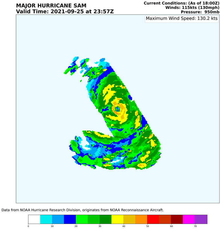
The NHC has been going 5kt above the BT intensity for several previous advisories, so given the wealth of recon data, they’ll probably go higher at 130 kt — although I’d go for 135 kt.
1 likes
Irene '11 Sandy '12 Hermine '16 5/15/2018 Derecho Fay '20 Isaias '20 Elsa '21 Henri '21 Ida '21
I am only a meteorology enthusiast who knows a decent amount about tropical cyclones. Look to the professional mets, the NHC, or your local weather office for the best information.
I am only a meteorology enthusiast who knows a decent amount about tropical cyclones. Look to the professional mets, the NHC, or your local weather office for the best information.

Re: ATL: SAM - Hurricane - Discussion
And just like that, Sam is back to almost as impressive as earlier (around the 5pm advisory time). Cloud tops might be even colder, though both the CDO and the eye are still a bit ragged.
0 likes
TC naming lists: retirements and intensity
Most aggressive Advisory #1's in North Atlantic (cr. kevin for starting the list)
Most aggressive Advisory #1's in North Atlantic (cr. kevin for starting the list)


-
wxman57

- Moderator-Pro Met

- Posts: 23175
- Age: 68
- Joined: Sat Jun 21, 2003 8:06 pm
- Location: Houston, TX (southwest)
Re: ATL: SAM - Hurricane - Discussion
I'm thinking the NHC might go with 125 kts. Max FL winds "only" 140 kts. Sam is a tiny hurricane. Looking more like it will safely miss the NE Caribbean islands and possibly Bermuda, too. Newfoundland might not be so lucky. Looks like Levi is having trouble with his website again.
8 likes
-
Iceresistance

- Category 5

- Posts: 9592
- Age: 22
- Joined: Sat Oct 10, 2020 9:45 am
- Location: Tecumseh, OK/Norman, OK
Re: ATL: SAM - Hurricane - Discussion
wxman57 wrote:I'm thinking the NHC might go with 125 kts. Max FL winds "only" 140 kts. Sam is a tiny hurricane. Looking more like it will safely miss the NE Caribbean islands and possibly Bermuda, too. Newfoundland might not be so lucky. Looks like Levi is having trouble with his website again.
At least it was working when Recon was inside the storm . . .
0 likes
Bill 2015 & Beta 2020
Winter 2020-2021
All observations are in Tecumseh, OK unless otherwise noted.
Winter posts are focused mainly for Oklahoma & Texas.
Take any of my forecasts with a grain of salt, refer to the NWS, SPC, and NHC for official information
Never say Never with weather! Because ANYTHING is possible!
Winter 2020-2021
All observations are in Tecumseh, OK unless otherwise noted.
Winter posts are focused mainly for Oklahoma & Texas.
Take any of my forecasts with a grain of salt, refer to the NWS, SPC, and NHC for official information
Never say Never with weather! Because ANYTHING is possible!
-
tolakram
- Admin

- Posts: 20186
- Age: 62
- Joined: Sun Aug 27, 2006 8:23 pm
- Location: Florence, KY (name is Mark)
Re: ATL: SAM - Hurricane - Discussion
zzh wrote:NHC just want to stick to their forecast, they ignored the recon.
That's absurd. Best Track is not NHC, NHC can and often does modify best track. They are not going to go with a figure just to "stick to their forecast'.
10 likes
M a r k
- - - - -
Join us in chat: Storm2K Chatroom Invite. Android and IOS apps also available.
The posts in this forum are NOT official forecasts and should not be used as such. Posts are NOT endorsed by any professional institution or STORM2K.org. For official information and forecasts, please refer to NHC and NWS products.
-
cheezyWXguy

- Category 5
- Posts: 6282
- Joined: Mon Feb 13, 2006 12:29 am
- Location: Dallas, TX
Re: ATL: SAM - Hurricane - Discussion
Sam is an impressive storm. The flat western edge of the cdo implies it may be dealing with some light shear, but since the coldest convection is upshear, I imagine it will at least maintain intensity. If the light shear breaks for just a couple of hours, it could reach cat 5 tonight
1 likes
-
Sciencerocks
- Category 5
- Posts: 10186
- Age: 40
- Joined: Thu Jul 06, 2017 1:51 am

-
EquusStorm
- Category 5
- Posts: 1649
- Age: 35
- Joined: Thu Nov 07, 2013 1:04 pm
- Location: Jasper, AL
- Contact:
Re: ATL: SAM - Hurricane - Discussion
It would be nice to get a high end hurricane with a normal wind profile again sometime; I have no idea what to make of the weird FL/SFMR disconnect. Stellar looking cane earlier though, glad we got another decent MDR storm after the last few sloppy looking strugglers.
2 likes
Colors of lost purpose on the canvas of irrelevance
Not a meteorologist, in fact more of an idiot than anything. You should probably check with the NHC or a local NWS office for official information.
Not a meteorologist, in fact more of an idiot than anything. You should probably check with the NHC or a local NWS office for official information.
-
Yellow Evan

- Professional-Met

- Posts: 16240
- Age: 27
- Joined: Fri Jul 15, 2011 12:48 pm
- Location: Henderson, Nevada/Honolulu, HI
- Contact:
Re: ATL: SAM - Hurricane - Discussion
wxman57 wrote:I'm thinking the NHC might go with 125 kts. Max FL winds "only" 140 kts. Sam is a tiny hurricane. Looking more like it will safely miss the NE Caribbean islands and possibly Bermuda, too. Newfoundland might not be so lucky. Looks like Levi is having trouble with his website again.
The 90% rule doesn't really always apply with intense hurricanes (see Patricia, Dorian, Irma, Maria).
9 likes

Re: ATL: SAM - Hurricane - Discussion
tolakram wrote:zzh wrote:NHC just want to stick to their forecast, they ignored the recon.
That's absurd. Best Track is not NHC, NHC can and often does modify best track. They are not going to go with a figure just to "stick to their forecast'.
Is it maintained by NRL?
0 likes
The above post is not official and should not be used as such. It is the opinion of the poster and may or may not be backed by sound meteorological data. It is not endorsed by any professional institution or storm2k.org. For official information, please refer to the NHC and NWS products.
-
skyline385

- Category 5
- Posts: 2728
- Age: 35
- Joined: Wed Aug 26, 2020 11:15 pm
- Location: Houston TX
Re: ATL: SAM - Hurricane - Discussion
Yellow Evan wrote:wxman57 wrote:I'm thinking the NHC might go with 125 kts. Max FL winds "only" 140 kts. Sam is a tiny hurricane. Looking more like it will safely miss the NE Caribbean islands and possibly Bermuda, too. Newfoundland might not be so lucky. Looks like Levi is having trouble with his website again.
The 90% rule doesn't really always apply with intense hurricanes (see Patricia, Dorian, Irma, Maria).
I was reading the Patricia discussions from the NHC archives a few days ago and remembered them talking about this
The plane measured peak 700-mb flight level winds of 179 kt in the northeastern eyewall, and this may be an unprecedented value for a tropical cyclone. Using the 90percent adjustment value to convert this to a surface wind speed yields an intensity estimate of 160 kt
The aircraft measured 192 kt flight-level winds at 700 mb in the southeastern eyewall, with a 166 kt surface wind estimate from the Stepped Frequency Microwave radiometer.
Last edited by skyline385 on Sat Sep 25, 2021 9:05 pm, edited 1 time in total.
0 likes
-
Yankee Corn Husker

- Tropical Low

- Posts: 15
- Age: 65
- Joined: Fri Sep 24, 2021 1:10 pm
Re: ATL: SAM - Hurricane - Discussion
HOLY COW! This pic actually sent a chill down my spine!
0 likes

Re: ATL: SAM - Hurricane - Discussion
Yankee Corn Husker wrote:
HOLY COW! This pic actually sent a chill down my spine!
Yeah, the eye actually looks like an eyeball!!! Spooky.
1 likes
-
CrazyC83
- Professional-Met
- Posts: 34315
- Joined: Tue Mar 07, 2006 11:57 pm
- Location: Deep South, for the first time!
Re: ATL: SAM - Hurricane - Discussion
Yellow Evan wrote:wxman57 wrote:I'm thinking the NHC might go with 125 kts. Max FL winds "only" 140 kts. Sam is a tiny hurricane. Looking more like it will safely miss the NE Caribbean islands and possibly Bermuda, too. Newfoundland might not be so lucky. Looks like Levi is having trouble with his website again.
The 90% rule doesn't really always apply with intense hurricanes (see Patricia, Dorian, Irma, Maria).
Those flight level winds translate to 126 kt at the surface. I see no reason to go at least 130 kt given the data.
2 likes
-
tolakram
- Admin
- Posts: 20186
- Age: 62
- Joined: Sun Aug 27, 2006 8:23 pm
- Location: Florence, KY (name is Mark)
Re: ATL: SAM - Hurricane - Discussion
Hammy wrote:tolakram wrote:zzh wrote:NHC just want to stick to their forecast, they ignored the recon.
That's absurd. Best Track is not NHC, NHC can and often does modify best track. They are not going to go with a figure just to "stick to their forecast'.
Is it maintained by NRL?
It's maintained by the NHC but the initial data is somewhat? automated (ATCF). http://hurricanes.ral.ucar.edu/realtime/
It's not the most clear cut process. I gather it's a best estimate prior to review, similar to DVORAK best estimates. Recon data is one of the review items, I don't know if ever makes it into best track real time, but I'm just not sure about it. Regardless, we have seen NHC increase and decrease best track after analysis.
2 likes
M a r k
- - - - -
Join us in chat: Storm2K Chatroom Invite. Android and IOS apps also available.
The posts in this forum are NOT official forecasts and should not be used as such. Posts are NOT endorsed by any professional institution or STORM2K.org. For official information and forecasts, please refer to NHC and NWS products.
- - - - -
Join us in chat: Storm2K Chatroom Invite. Android and IOS apps also available.
The posts in this forum are NOT official forecasts and should not be used as such. Posts are NOT endorsed by any professional institution or STORM2K.org. For official information and forecasts, please refer to NHC and NWS products.
-
supercane4867
- Category 5
- Posts: 4966
- Joined: Wed Nov 14, 2012 10:43 am
Re: ATL: SAM - Hurricane - Discussion
EquusStorm wrote:It would be nice to get a high end hurricane with a normal wind profile again sometime; I have no idea what to make of the weird FL/SFMR disconnect. Stellar looking cane earlier though, glad we got another decent MDR storm after the last few sloppy looking strugglers.
There is no such thing as a "normal" wind profile. The standard deduction used for the conversion of FL level to surface winds is derived from historical dropsonde data itself and is by no means conclusive. In Sam's case the boundary layer measurements from dropsonde clearly supports an intensity higher than what the standard deduction implies and thus should be given more weight in the assessment
3 likes

Re: ATL: SAM - Hurricane - Discussion
supercane4867 wrote:EquusStorm wrote:It would be nice to get a high end hurricane with a normal wind profile again sometime; I have no idea what to make of the weird FL/SFMR disconnect. Stellar looking cane earlier though, glad we got another decent MDR storm after the last few sloppy looking strugglers.
There is no such thing as a "normal" wind profile. The standard deduction used for the conversion of FL level to surface winds is derived from historical dropsonde data itself and is by no means conclusive. In Sam's case the boundary layer measurements from dropsonde clearly supports an intensity higher than what the standard deduction implies and thus should be given more weight in the assessment
Further research needed. Sam's tight melded core is quite rare and the few similar cyclones that have been sampled displayed a downward shift in vertical wind profile. Sam is especially low latitude which only compounds that. Even accounting for the SFMR bias, 125kt seems low.
3 likes
Kendall -> SLO -> PBC
Memorable Storms: Katrina (for its Florida landfall...) Wilma Matthew Irma
Memorable Storms: Katrina (for its Florida landfall...) Wilma Matthew Irma
Re: ATL: SAM - Hurricane - Discussion
Ubuntwo wrote:supercane4867 wrote:EquusStorm wrote:It would be nice to get a high end hurricane with a normal wind profile again sometime; I have no idea what to make of the weird FL/SFMR disconnect. Stellar looking cane earlier though, glad we got another decent MDR storm after the last few sloppy looking strugglers.
There is no such thing as a "normal" wind profile. The standard deduction used for the conversion of FL level to surface winds is derived from historical dropsonde data itself and is by no means conclusive. In Sam's case the boundary layer measurements from dropsonde clearly supports an intensity higher than what the standard deduction implies and thus should be given more weight in the assessment
Further research needed. Sam's tight melded core is quite rare and the few similar cyclones that have been sampled displayed a downward shift in vertical wind profile. Sam is especially low latitude which only compounds that. Even accounting for the SFMR bias, 125kt seems low.
Is Sam still supposed to miss the Lesser Antilles. I hear lots of discussion about strength but not so much about its track. It sure seems to be moving more
west or maybe wnw and that could be a problem perhaps.
0 likes

Re: ATL: SAM - Hurricane - Discussion
LOCATION...13.5N 49.0W
ABOUT 990 MI...1595 KM ESE OF THE NORTHERN LEEWARD ISLANDS
MAXIMUM SUSTAINED WINDS...145 MPH...230 KM/H
PRESENT MOVEMENT...WNW OR 295 DEGREES AT 8 MPH...13 KM/H
MINIMUM CENTRAL PRESSURE...943 MB...27.85 INCHES
ABOUT 990 MI...1595 KM ESE OF THE NORTHERN LEEWARD ISLANDS
MAXIMUM SUSTAINED WINDS...145 MPH...230 KM/H
PRESENT MOVEMENT...WNW OR 295 DEGREES AT 8 MPH...13 KM/H
MINIMUM CENTRAL PRESSURE...943 MB...27.85 INCHES
First!
Last edited by abajan on Sat Sep 25, 2021 9:52 pm, edited 1 time in total.
1 likes
Who is online
Users browsing this forum: No registered users and 20 guests