2021 Global Model Runs Discussion (Out thru day 16)

This is the general tropical discussion area. Anyone can take their shot at predicting a storms path.

Moderator: S2k Moderators

Forum rules

The posts in this forum are NOT official forecasts and should not be used as such. They are just the opinion of the poster and may or may not be backed by sound meteorological data. They are NOT endorsed by any professional institution or STORM2K. For official information, please refer to products from the National Hurricane Center and National Weather Service.

Help Support Storm2K
Message
Author
User avatar
kevin
Category 5
Category 5
Posts: 2554
Age: 26
Joined: Wed Aug 28, 2019 4:35 am

Re: 2021 Global Model Runs Discussion (Out thru day 16)

#1881 Postby kevin » Fri Oct 01, 2021 8:37 am

LarryWx wrote:
kevin wrote:06zGFS, probably the busiest GFS ensemble we've had in the last few weeks since Sam formed. It consists of three independent clusters within the next 200 hours: WCar activity around +120 (11 members, 50%), weak subtropical development N of the Bahamas around +132 (13 members, 59%), even more WCar activity around +180 (not really sure how many members since it's difficult to distinguish from the first AOI). However the Euro is still very quiet so we'll see what happens.

https://i.imgur.com/2iFoNXm.png


Good post. To add, the GEFS now has 31-32 members instead of just 21-22.


Thanks for the correction, I have to keep myself more up to date on these model upgrades. In that case the percentages are 35% and 41%, respectively.
2 likes   

User avatar
gatorcane
S2K Supporter
S2K Supporter
Posts: 23689
Age: 47
Joined: Sun Mar 13, 2005 3:54 pm
Location: Boca Raton, FL

Re: 2021 Global Model Runs Discussion (Out thru day 16)

#1882 Postby gatorcane » Fri Oct 01, 2021 9:47 am

I am a little skeptical of the GFS storm as well seeing how it seems to develop out of “thin air” (unless I am missing something). Also looks small as well. There is one model that is showing a low also and that is the ICON.

GFS animation:
Image

ICON:
Image
0 likes   

User avatar
Ubuntwo
Category 5
Category 5
Posts: 1401
Age: 31
Joined: Thu Oct 05, 2017 10:41 pm

Re: 2021 Global Model Runs Discussion (Out thru day 16)

#1883 Postby Ubuntwo » Fri Oct 01, 2021 10:18 am

gatorcane wrote:I am a little skeptical of the GFS storm as well seeing how it seems to develop out of “thin air” (unless I am missing something). Also looks small as well. There is one model that is showing a low also and that is the ICON.

The impulse is the tropical wave currently east of the Caribbean. I believe it was marked as an invest at one point.
0 likes   
Kendall -> SLO -> PBC

Memorable Storms: Katrina (for its Florida landfall...) Wilma Matthew Irma

User avatar
Category5Kaiju
Category 5
Category 5
Posts: 4052
Joined: Thu Dec 24, 2020 12:45 pm
Location: Seattle

Re: 2021 Global Model Runs Discussion (Out thru day 16)

#1884 Postby Category5Kaiju » Fri Oct 01, 2021 10:26 am

Actually the GFS's idea of how this potential WCAR system sets up is somewhat like Michael or Nate, where there's a CAG and a sleeper tropical wave sparks the cyclonic flow; for early October and a rising CCKW in that specific region of the Atlantic during that timeframe, its' not that unreasonable to see something like that
1 likes   
Unless explicitly stated, all info in my posts is based on my own opinions and observations. Tropical storms and hurricanes can be extremely dangerous. Do not think you can beat Mother Nature. Refer to an accredited weather research agency or meteorologist if you need to make serious decisions regarding an approaching storm.

User avatar
chaser1
S2K Supporter
S2K Supporter
Posts: 5407
Age: 64
Joined: Sat Oct 15, 2005 5:59 pm
Location: Longwood, Fl

Re: 2021 Global Model Runs Discussion (Out thru day 16)

#1885 Postby chaser1 » Fri Oct 01, 2021 10:34 am

kevin wrote:
LarryWx wrote:
kevin wrote:06zGFS, probably the busiest GFS ensemble we've had in the last few weeks since Sam formed. It consists of three independent clusters within the next 200 hours: WCar activity around +120 (11 members, 50%), weak subtropical development N of the Bahamas around +132 (13 members, 59%), even more WCar activity around +180 (not really sure how many members since it's difficult to distinguish from the first AOI). However the Euro is still very quiet so we'll see what happens.

https://i.imgur.com/2iFoNXm.png


Good post. To add, the GEFS now has 31-32 members instead of just 21-22.


Thanks for the correction, I have to keep myself more up to date on these model upgrades. In that case the percentages are 35% and 41%, respectively.


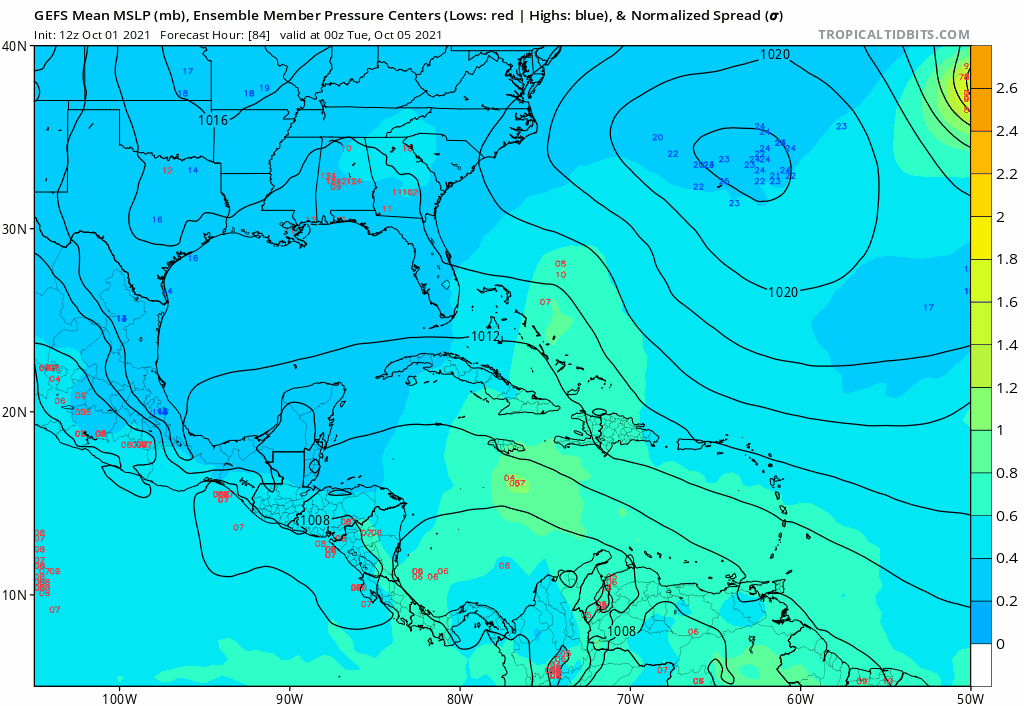
The only nuance that I can take away this early is that it appears to me that the 6Z GFS ensembles have seemed to additionally trended a bit westward over the recent runs. Spread out as they are still, I'm less focused in on the 6Z Operational forecast for the small forecasted low that develops just south of Jamaica at 114 hr.'s, especially given the only other model suggesting vague support being ICON with broad 1008 pressures primarily parked further south and west in the Caribbean. I personally think that any development that might occur in the West or Central Caribbean which the GFS is hinting, will:
1) be enhanced or develop from the southern extension of the TW previously associated with "ex-91L"..... and
2) Probably not consolidate quite as early as the 6Z Operational GFS presently suggests at around 114 hr's, but perhaps more like 1-3 days further out.

Ultimately, it's yet to be seen whether the GFS will even begin to show model run after run forecast consistency for a Caribbean disturbance. Happy hour is over and let's see if the 12Z concurs. I don't expect it to... "quite yet" though. Probably best to just see what trends the ensembles suggest and whether other models (UK included) begin to hint toward development as well. My only concern with this presently "low confidence" potential disturbance is, that IF genesis were to occur but the time frame be pushed a bit further out then there may be increased mid level ridging taking place and possibly increased risk of Yucatan or East GOM impact at such a time.
0 likes   
Andy D

(For official information, please refer to the NHC and NWS products.)

User avatar
chaser1
S2K Supporter
S2K Supporter
Posts: 5407
Age: 64
Joined: Sat Oct 15, 2005 5:59 pm
Location: Longwood, Fl

Re: 2021 Global Model Runs Discussion (Out thru day 16)

#1886 Postby chaser1 » Fri Oct 01, 2021 10:39 am

Ubuntwo wrote:
gatorcane wrote:I am a little skeptical of the GFS storm as well seeing how it seems to develop out of “thin air” (unless I am missing something). Also looks small as well. There is one model that is showing a low also and that is the ICON.

The impulse is the tropical wave currently east of the Caribbean. I believe it was marked as an invest at one point.


You beat me to it LOL. I agree with yours and Catagory5Kaiju thoughts. This time of year, just takes one match.... especially if there's a broad CAG tinderbox already in place.
0 likes   
Andy D

(For official information, please refer to the NHC and NWS products.)

User avatar
chris_fit
Category 5
Category 5
Posts: 3222
Age: 42
Joined: Wed Sep 10, 2003 11:58 pm
Location: Tampa Bay Area, FL

Re: 2021 Global Model Runs Discussion (Out thru day 16)

#1887 Postby chris_fit » Fri Oct 01, 2021 11:13 am

Looks like 12Z GFS OP coming in a little stronger this time, so far...

Edit - Not stronger, but still there

Here's a trend
Image
0 likes   

User avatar
'CaneFreak
Category 5
Category 5
Posts: 1486
Joined: Mon Jun 05, 2006 10:50 am
Location: New Bern, NC

Re: 2021 Global Model Runs Discussion (Out thru day 16)

#1888 Postby 'CaneFreak » Fri Oct 01, 2021 11:24 am

Yeah I'm trying to figure out what is going on. At hour 115, on the GFS Forecast Satellite it shows a very robust looking TC over Jamaica. But in the subsequent frames on the MSLP, it shows it diminishing and we lose it. The UL winds are very favorable with a large anticyclone overhead. So I wonder if it is dry air that kills it, interaction with land kills it, or why the GFS all of a sudden drops it. Maybe it is some kind of feedback issue?
0 likes   

User avatar
chris_fit
Category 5
Category 5
Posts: 3222
Age: 42
Joined: Wed Sep 10, 2003 11:58 pm
Location: Tampa Bay Area, FL

Re: 2021 Global Model Runs Discussion (Out thru day 16)

#1889 Postby chris_fit » Fri Oct 01, 2021 11:43 am

Here's the interesting 12Z GPS Op Run through 240 hours - I don't think anything else after that really matters...

Image
0 likes   

User avatar
SFLcane
S2K Supporter
S2K Supporter
Posts: 10162
Age: 47
Joined: Sat Jun 05, 2010 1:44 pm
Location: Lake Worth Florida

Re: 2021 Global Model Runs Discussion (Out thru day 16)

#1890 Postby SFLcane » Fri Oct 01, 2021 11:58 am

chris_fit wrote:Here's the interesting 12Z GPS Op Run through 240 hours - I don't think anything else after that really matters...

https://i.imgur.com/fVgiyW7.gif


Looks like it develops in the subtropics.
0 likes   

User avatar
chris_fit
Category 5
Category 5
Posts: 3222
Age: 42
Joined: Wed Sep 10, 2003 11:58 pm
Location: Tampa Bay Area, FL

Re: 2021 Global Model Runs Discussion (Out thru day 16)

#1891 Postby chris_fit » Fri Oct 01, 2021 12:07 pm

GEFS are coming in quite a but W of the OP - and they are being feisty @ 180hrs already!
0 likes   

User avatar
toad strangler
S2K Supporter
S2K Supporter
Posts: 4543
Joined: Sun Jul 28, 2013 3:09 pm
Location: Earth
Contact:

Re: 2021 Global Model Runs Discussion (Out thru day 16)

#1892 Postby toad strangler » Fri Oct 01, 2021 12:18 pm

chris_fit wrote:GEFS are coming in quite a but W of the OP - and they are being feisty @ 180hrs already!


ya, 12z GEFS rather active and honing in on the Fl peninsula ….. this go around.
0 likes   

User avatar
gatorcane
S2K Supporter
S2K Supporter
Posts: 23689
Age: 47
Joined: Sun Mar 13, 2005 3:54 pm
Location: Boca Raton, FL

Re: 2021 Global Model Runs Discussion (Out thru day 16)

#1893 Postby gatorcane » Fri Oct 01, 2021 12:25 pm

toad strangler wrote:
chris_fit wrote:GEFS are coming in quite a but W of the OP - and they are being feisty @ 180hrs already!


ya, 12z GEFS rather active and honing in on the Fl peninsula ….. this go around.


Saved loop:

Image
0 likes   

AutoPenalti
Category 5
Category 5
Posts: 4029
Age: 28
Joined: Mon Aug 17, 2015 4:16 pm
Location: Ft. Lauderdale, Florida

Re: 2021 Global Model Runs Discussion (Out thru day 16)

#1894 Postby AutoPenalti » Fri Oct 01, 2021 12:31 pm

gatorcane wrote:
toad strangler wrote:
chris_fit wrote:GEFS are coming in quite a but W of the OP - and they are being feisty @ 180hrs already!


ya, 12z GEFS rather active and honing in on the Fl peninsula ….. this go around.


Saved loop:

https://i.postimg.cc/zG8pp93y/gfs-ememb-lowlocs-watl-fh84-222.gif

It's interesting that no other models except the ICON show this.
0 likes   
The posts in this forum are NOT official forecasts and should not be used as such. They are just the opinion of the poster and may or may not be backed by sound meteorological data. They are NOT endorsed by any professional institution or STORM2K. For official information, please refer to products from the NHC and NWS.


Model Runs Cheat Sheet:
GFS (5:30 AM/PM, 11:30 AM/PM)
HWRF, GFDL, UKMET, NAVGEM (6:30-8:00 AM/PM, 12:30-2:00 AM/PM)
ECMWF (1:45 AM/PM)

TCVN
is a weighted averaged

User avatar
chris_fit
Category 5
Category 5
Posts: 3222
Age: 42
Joined: Wed Sep 10, 2003 11:58 pm
Location: Tampa Bay Area, FL

Re: 2021 Global Model Runs Discussion (Out thru day 16)

#1895 Postby chris_fit » Fri Oct 01, 2021 12:37 pm

That one Ens Member pretty much shows a 1921 Tampa Bay hurricane redux

Image
0 likes   

User avatar
chris_fit
Category 5
Category 5
Posts: 3222
Age: 42
Joined: Wed Sep 10, 2003 11:58 pm
Location: Tampa Bay Area, FL

Re: 2021 Global Model Runs Discussion (Out thru day 16)

#1896 Postby chris_fit » Fri Oct 01, 2021 12:40 pm

AutoPenalti wrote:
gatorcane wrote:
toad strangler wrote:
ya, 12z GEFS rather active and honing in on the Fl peninsula ….. this go around.


Saved loop:

https://i.postimg.cc/zG8pp93y/gfs-ememb-lowlocs-watl-fh84-222.gif

It's interesting that no other models except the ICON show this.


And also interesting that the GEFS having hinting at something for over a week now, with the time frame coming in. Either it's really right, or really wrong! Being that it trumped Sam over pretty much every other model - it raises an eyebrow.
0 likes   

User avatar
Category5Kaiju
Category 5
Category 5
Posts: 4052
Joined: Thu Dec 24, 2020 12:45 pm
Location: Seattle

Re: 2021 Global Model Runs Discussion (Out thru day 16)

#1897 Postby Category5Kaiju » Fri Oct 01, 2021 12:43 pm

chris_fit wrote:That one Ens Member pretty much shows a 1921 Tampa Bay hurricane redux

https://i.imgur.com/FLOgy8a.gif


Imagine the "Big One" occurring exactly 100 years after the last "Big One," now that would be a storm that would almost certainly be talked about by wx enthusiasts and mets for a while going forward. We'll see if the GEFS is right or wrong, but it certainly looks to be bullish on something in that region in early-mid October.
2 likes   
Unless explicitly stated, all info in my posts is based on my own opinions and observations. Tropical storms and hurricanes can be extremely dangerous. Do not think you can beat Mother Nature. Refer to an accredited weather research agency or meteorologist if you need to make serious decisions regarding an approaching storm.

User avatar
chris_fit
Category 5
Category 5
Posts: 3222
Age: 42
Joined: Wed Sep 10, 2003 11:58 pm
Location: Tampa Bay Area, FL

Re: 2021 Global Model Runs Discussion (Out thru day 16)

#1898 Postby chris_fit » Fri Oct 01, 2021 12:48 pm

Category5Kaiju wrote:
chris_fit wrote:That one Ens Member pretty much shows a 1921 Tampa Bay hurricane redux

https://i.imgur.com/FLOgy8a.gif


Imagine the "Big One" occurring exactly 100 years after the last "Big One," now that would be a storm that would almost certainly be talked about by wx enthusiasts and mets for a while going forward. We'll see if the GEFS is right or wrong, but it certainly looks to be bullish on something in that region in early-mid October.


Wow I didn't even realize that would be exactly 100 years ago! That would be somethin'!
0 likes   

User avatar
Spacecoast
Category 2
Category 2
Posts: 758
Joined: Thu Aug 31, 2017 2:03 pm

Re: 2021 Global Model Runs Discussion (Out thru day 16)

#1899 Postby Spacecoast » Fri Oct 01, 2021 12:55 pm

12z GEFS...about 7-11 members head N into Gulf...shear disappears
Image
Last edited by Spacecoast on Fri Oct 01, 2021 1:17 pm, edited 2 times in total.
0 likes   

User avatar
SFLcane
S2K Supporter
S2K Supporter
Posts: 10162
Age: 47
Joined: Sat Jun 05, 2010 1:44 pm
Location: Lake Worth Florida

Re: 2021 Global Model Runs Discussion (Out thru day 16)

#1900 Postby SFLcane » Fri Oct 01, 2021 1:12 pm

GEFS Seems like convective bias to me. Nothing else has anything.
0 likes   


Return to “Talkin' Tropics”

Who is online

Users browsing this forum: hurricanes1234, MarioProtVI, mixedDanilo.E, Sciencerocks and 179 guests