2021 Global Model Runs Discussion (Out thru day 16)
Moderator: S2k Moderators
Forum rules

The posts in this forum are NOT official forecasts and should not be used as such. They are just the opinion of the poster and may or may not be backed by sound meteorological data. They are NOT endorsed by any professional institution or STORM2K. For official information, please refer to products from the National Hurricane Center and National Weather Service.

Re: 2021 Global Model Runs Discussion (Out thru day 16)
18z GEFS have less support for the operational GFS’ Omar/Sebastian hybrid and more support for a WCar system like what the CMC is suggesting.
0 likes
Irene '11 Sandy '12 Hermine '16 5/15/2018 Derecho Fay '20 Isaias '20 Elsa '21 Henri '21 Ida '21
I am only a meteorology enthusiast who knows a decent amount about tropical cyclones. Look to the professional mets, the NHC, or your local weather office for the best information.
I am only a meteorology enthusiast who knows a decent amount about tropical cyclones. Look to the professional mets, the NHC, or your local weather office for the best information.
Re: 2021 Global Model Runs Discussion (Out thru day 16)
18Z & 0Z GEFS/12Z EPS about as busy as anytime recently late in their runs in the W Caribbean. Early Nov climo supports this to some extent with still a respectable 13 geneses over the 10 day period 11/1-10 vs about the same rate during the 11 day period 10/21-31 of 15..so this area may bear watching, folks, as that's one every 13 years on average with the last one being Ida of 2009:

2 likes
Personal Forecast Disclaimer:
The posts in this forum are NOT official forecasts and should not be used as such. They are just the opinion of the poster and may or may not be backed by sound meteorological data. They are NOT endorsed by any professional institution or storm2k.org. For official information, please refer to the NHC and NWS products.
The posts in this forum are NOT official forecasts and should not be used as such. They are just the opinion of the poster and may or may not be backed by sound meteorological data. They are NOT endorsed by any professional institution or storm2k.org. For official information, please refer to the NHC and NWS products.
Re: 2021 Global Model Runs Discussion (Out thru day 16)
00z CMC shows a little more development with its SW Caribbean low, and its ensembles show it too. The GEFS continues to lean towards that system as well.
0 likes
Irene '11 Sandy '12 Hermine '16 5/15/2018 Derecho Fay '20 Isaias '20 Elsa '21 Henri '21 Ida '21
I am only a meteorology enthusiast who knows a decent amount about tropical cyclones. Look to the professional mets, the NHC, or your local weather office for the best information.
I am only a meteorology enthusiast who knows a decent amount about tropical cyclones. Look to the professional mets, the NHC, or your local weather office for the best information.
-
crownweather

- S2K Supporter

- Posts: 576
- Age: 49
- Joined: Sat Aug 12, 2006 9:21 am
- Location: Sturbridge, Massachusetts
- Contact:
Re: 2021 Global Model Runs Discussion (Out thru day 16)
aspen wrote:00z CMC shows a little more development with its SW Caribbean low, and its ensembles show it too. The GEFS continues to lean towards that system as well.
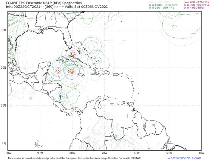
00Z EPS is showing an uptick in members showing development right at the start of November in the western Caribbean.
1 likes
Rob Lightbown
Crown Weather Services
https://crownweather.com
Crown Weather Services
https://crownweather.com
Re: 2021 Global Model Runs Discussion (Out thru day 16)
06z GFS has finally caved into the CMC and ensembles, and shows the wave becoming a system with an Eta/Iota-like track in the WCar instead of an Omar-like OTS system in the East Caribbean. It even has the same time frame as Eta.
0 likes
Irene '11 Sandy '12 Hermine '16 5/15/2018 Derecho Fay '20 Isaias '20 Elsa '21 Henri '21 Ida '21
I am only a meteorology enthusiast who knows a decent amount about tropical cyclones. Look to the professional mets, the NHC, or your local weather office for the best information.
I am only a meteorology enthusiast who knows a decent amount about tropical cyclones. Look to the professional mets, the NHC, or your local weather office for the best information.

Re: 2021 Global Model Runs Discussion (Out thru day 16)
aspen wrote:00z CMC shows a little more development with its SW Caribbean low, and its ensembles show it too. The GEFS continues to lean towards that system as well.
That’s originating from the same wave earlier GFS runs developed in the eastern Caribbean. Just with different synoptics - increased heights keeping the wave low until the western Caribbean. If troughing remains weak, could continue into Central America without doing much. So development hinges on hard to forecast specifics. Still very far out.
3 likes
Kendall -> SLO -> PBC
Memorable Storms: Katrina (for its Florida landfall...) Wilma Matthew Irma
Memorable Storms: Katrina (for its Florida landfall...) Wilma Matthew Irma
-
Iceresistance

- Category 5

- Posts: 8913
- Age: 20
- Joined: Sat Oct 10, 2020 9:45 am
- Location: Tecumseh, OK/Norman, OK
Re: 2021 Global Model Runs Discussion (Out thru day 16)
6z GFS sends the Caribbean system to Nicaragua, just like Eta & Iota did last year
0 likes
Bill 2015 & Beta 2020
Winter 2020-2021
All observations are in Tecumseh, OK unless otherwise noted.
Winter posts are focused mainly for Oklahoma & Texas.
Take any of my forecasts with a grain of salt, refer to the NWS, SPC, and NHC for official information
Never say Never with weather! Because ANYTHING is possible!
Winter 2020-2021
All observations are in Tecumseh, OK unless otherwise noted.
Winter posts are focused mainly for Oklahoma & Texas.
Take any of my forecasts with a grain of salt, refer to the NWS, SPC, and NHC for official information
Never say Never with weather! Because ANYTHING is possible!


-
Category5Kaiju

- Category 5
- Posts: 3357
- Age: 22
- Joined: Thu Dec 24, 2020 12:45 pm
- Location: Seattle
Re: 2021 Global Model Runs Discussion (Out thru day 16)
Considering how troughiness has been a dominant player in this season compared to, say, 2020, I think if something were to develop in the WCAR it would more than likely lift northward like Elsa or Ida rather than bury itself in C America like Eta or Iota. Just a personal thought though
3 likes
Unless explicitly stated, all information covered in my posts is based on my opinions and observations. Please refer to a professional meteorologist or an accredited weather research agency otherwise, especially if serious decisions must be made in the event of a potentially life-threatening tropical storm or hurricane.
-
SFLcane

- S2K Supporter
- Posts: 9606
- Age: 46
- Joined: Sat Jun 05, 2010 1:44 pm
- Location: Lake Worth Florida
Re: 2021 Global Model Runs Discussion (Out thru day 16)
Combo of the tropical wave over the Atlantic and then the stalling front after it pushes through here would be catalyst. But again we’ll see
0 likes
Re: 2021 Global Model Runs Discussion (Out thru day 16)
The 12z GFS has even stronger ridging burying the wave into South America, no development. This is similar to what the Euro has been showing all along. Just one run but that’s what it shows.
0 likes
Kendall -> SLO -> PBC
Memorable Storms: Katrina (for its Florida landfall...) Wilma Matthew Irma
Memorable Storms: Katrina (for its Florida landfall...) Wilma Matthew Irma
-
Category5Kaiju
- Category 5
- Posts: 3357
- Age: 22
- Joined: Thu Dec 24, 2020 12:45 pm
- Location: Seattle
Re: 2021 Global Model Runs Discussion (Out thru day 16)
Oh of course the GFS did that, although I will say given its pretty decent consistency in consecutive runs prior to this that had that sort of system, I honestly do not believe that this 12z run is well representative of what will likely pan out in the future.
0 likes
Unless explicitly stated, all information covered in my posts is based on my opinions and observations. Please refer to a professional meteorologist or an accredited weather research agency otherwise, especially if serious decisions must be made in the event of a potentially life-threatening tropical storm or hurricane.
Re: 2021 Global Model Runs Discussion (Out thru day 16)
I thought ‘phantom’ described model storms with no associated impulse other than “mystery vorticity”? Not the case here, wave is in the central Atlantic:

Last edited by Ubuntwo on Fri Oct 22, 2021 2:26 pm, edited 1 time in total.
0 likes
Kendall -> SLO -> PBC
Memorable Storms: Katrina (for its Florida landfall...) Wilma Matthew Irma
Memorable Storms: Katrina (for its Florida landfall...) Wilma Matthew Irma
-
CyclonicFury

- Category 5
- Posts: 1975
- Age: 25
- Joined: Sun Jul 02, 2017 12:32 pm
- Location: NC
- Contact:
Re: 2021 Global Model Runs Discussion (Out thru day 16)
I wouldn't dismiss it as a phantom just yet when EPS and CMC have also been showing genesis down there.
2 likes
NCSU B.S. in Meteorology Class of 2021. Tropical weather blogger at http://www.cyclonicfury.com. My forecasts and thoughts are NOT official, for official forecasts please consult the National Hurricane Center.

Re: 2021 Global Model Runs Discussion (Out thru day 16)
Yeah the OPS was always suspect. The GEFS looks like the real deal though very close to the CMC and last night Euro. This is going to be more of a W. Carribean system. I expect the 18z Ops to bring something back but closer to GEFS.
1 likes
The following post is NOT an official forecast and should not be used as such. It is just the opinion of the poster and may or may not be backed by sound meteorological data. It is NOT endorsed by any professional institution including storm2k.org For Official Information please refer to the NHC and NWS products.
-
Category5Kaiju
- Category 5
- Posts: 3357
- Age: 22
- Joined: Thu Dec 24, 2020 12:45 pm
- Location: Seattle
Re: 2021 Global Model Runs Discussion (Out thru day 16)
Also keep in mind that the GEFS has a tendency (for reasons I am not sure about) to show a system in consecutive runs, drop it, and then resurrect it when the time period gets closer.
2 likes
Unless explicitly stated, all information covered in my posts is based on my opinions and observations. Please refer to a professional meteorologist or an accredited weather research agency otherwise, especially if serious decisions must be made in the event of a potentially life-threatening tropical storm or hurricane.
Re: 2021 Global Model Runs Discussion (Out thru day 16)
GEFS ensembles still show an Eta-like storm at the same time frame as last run, and while the GEPS (CMC) ensembles also show a WCar system, it isn’t until a day or two later.
0 likes
Irene '11 Sandy '12 Hermine '16 5/15/2018 Derecho Fay '20 Isaias '20 Elsa '21 Henri '21 Ida '21
I am only a meteorology enthusiast who knows a decent amount about tropical cyclones. Look to the professional mets, the NHC, or your local weather office for the best information.
I am only a meteorology enthusiast who knows a decent amount about tropical cyclones. Look to the professional mets, the NHC, or your local weather office for the best information.
-
AlphaToOmega
- Category 5
- Posts: 1448
- Joined: Sat Jun 26, 2021 10:51 am
- Location: Somewhere in Massachusetts
Re: 2021 Global Model Runs Discussion (Out thru day 16)
As of now, the GEFS and ECENS ensembles have settled on a compromise in terms of deep tropics activity: they both agree on a Western Caribbean storm (a la Beta (2005) et Eta (2020)), and they both, bizarrely, agree on an MDR system (a la rien). In terms of the subtropics, the GEFS is catching a subtropical system forming around October 27, but the ECENS is not. The Western Caribbean and subtropics model storms are reasonable given the time of year; however, I have difficulty wrapping my head around the MDR storm. Normally, I would say the part of the MDR east of 35 W is closed November, but the ensembles keep latching onto this system: is there something they are seeing that I am not seeing?
0 likes
Who is online
Users browsing this forum: Christiana, Google [Bot], NotSparta, tiger_deF and 170 guests