Ok, I'm going to try starting a discussion on how intense Typhoon Rai was, since that's kind of the point of this forum
(I've tried spurring the discussion elsewhere
Twitter is much too rude for my taste, and people seem unable to accept that the JTWC or just other people in general can have their own opinion and that that's ok, and also the limit for wordcount is too tight for any kind of proper discussion
I've tried in the forum here about Rai but I think there's other stuff that should also be focused on there
but I decided to go with another Storm2K forum because people here seem to be more civil)
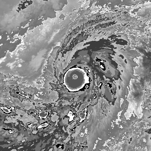
The topic of the discussion is simple: how strong was Rai at both its first (Philippine Sea) and second peak (South China Sea), and how intense was it throughout the Philippines? Most people I've seen can generally agree on 135-140kt for its first peak (high-end cat 4 to low-end cat 5), but there's a lot, lot, more debate on its second peak.
As for it's first peak, I don't know of any direct measurements from stations or barometers on Siargao or the Dinagat Islands that didn't stop recording mid-way through. However, I believe Rai was trying to undergo an eyewall replacement cycle and weakened to category 4 intensity soon after landfall anyways (based on the JTWC's estimate). But for this peak, most people can agree on 140kt (some 135kt but that's barely a difference), which is the JTWC's intensity estimate.
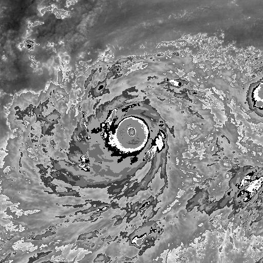
For the intensity throughout the Philippines, I've found some direct measurements. There was
950.5mb recorded north of the eye in Maasin City (Southern Leyte) at 18:00 PST (10:00 UTC) (thanks to user
Imran_doomhaMwx for the information).
After looking through Philsensors data I found some other stuff (all recordings listed will be for 16 Dec unless stated otherwise). For Southern Leyte, a station in Malitbog recorded 988.7mb (1000.9mb at SLP assuming stated elevation of 107 is in meters) at 14:18 PST (6:18 UTC).
For Bohol, a station in Dagohoy recorded 954.78mb at 19:45 (11:45 UTC), Dangay Elementary School at Alburquerque recorded 975.83mb at 20:45 PST (12:45 UTC), DOST PSTC Bohol, Tagbilaran recorded 984.07mb at 21:45 PST (13:45 UTC), and San Miguel Municipal Hall, San Miguel recorded 971.13mb at 19:45 PST (11:45 UTC); all measurements were south of the eye and are station pressures (elevation unknown).
For Cebu, Motorpool Cansaga, Consolacion recorded 985.54mb (it says 98554.0 but I think that's an error) at 21:00 PST (13:00 UTC), BRGY. Canjue, Argao, recorded 908.1mb at 22:00 PST (14:00 UTC), 960.68mb and 973.9mb was recorded at Toledo City by two different sensors at 20:00 PST (12:00 UTC) and 19:00 PST (11:00 UTC) respectively, BRGY. Hall Manipis, Talisay City recorded 939.05mb at 20:00 PST (12:00 UTC), BRGY. Poblacion, Ginatilan recorded 987.55mb at 00:00 PST on 17 Dec (16:00 UTC 16 Dec), Catmon Seaside Park Flores, Catmon recorded 996.17mb at 19:45 PST (11:45 UTC), Cordova Municipal Hall recorded 969.34mb on 21:30 PST (13:30 UTC) (elevation is stated at 30, I'm assuming meters, but no temperature), DOST VII, Cebu City recorded 976.12mb at 21:30 PST (13:30 UTC) (elevation is stated at 62; no temp), Moalboal recorded 968.73mb at 22:30 PST (14:30 UTC) (elevation is stated at 1; no temp), Ollfi, Sibonga recorded 967.59mb at 21:30 PST (13:30 UTC) (elevation is stated at 88; no temp), Pasil, Santander recorded 989.73mb at 22:45 PST (14:45 UTC) (elevation is stated at 19; no temp), Pinamungajan, Pandacan recorded 982.35mb 22:00 PST (14:00 UTC) (elevation is stated at 29; no temp), Central Visayas Campus, Argao recorded 951.45mb at 22:30 PST (14:30 UTC), and Cabancalan-Canduman Bridge, Mandaue City recorded 980.7mb at 20:40 PST (12:40 UTC). All aforementioned readings are station level pressure.
There's more places but it's taking forever to sort through them. It doesn't look like that much but most of the stations are non-operational and I have to look through those as well.
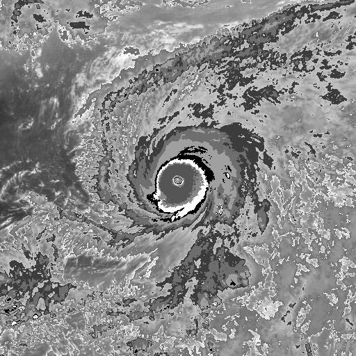
For the second peak, this is what people cannot agree on. The JTWC put the intensity at 145kt, but I believe they changed it to 140kt. Now, Most people, specifically on Twitter, think it was 125-130kt at second peak intensity (I think I saw someone say 135kt-140kt and another 140kt) and that the JTWC was overestimating it due to Dvorak.
At 15:05 Vietnam Time (8:05 UTC) on the 18th of October, 953mb was recorded on Southwest Cay (possibly in the eye), and, I quote: "The wind recorded at 13:52 was 45.61m/s; wind gust 56.79m/s." (I got the info from a YT reply and I would like to give this person credit however I'm not sure if they're comfortable with it). Twitter user Joshua C. Agar stated in a tweet that (about the station readings): "Second photo is the simulated 10-min sustained winds, with max 10-min wind estimate to be 49.35 m/s at 14:00 (GMT+7). Max. gust projected was 60.7 m/s. #Rai doesn't sound like Cat. 5." I'm assuming this was supposed to debunk the JTWC's category 5 estimate; ironically, this actually supports their estimate for the time, which was 110-115kt (110kt on 06:00 UTC and 115kt at 12:00 UTC), and they upgraded Rai to a category 5 nearly 10 hours (around 18:00 UTC) after the 953mb reading was recorded and 11 hours after the simulated wind speeds. Unfortunately, as far as I know, there was nothing to directly record Rai's intensity at 18:00 UTC.
All of this of course, is very confusing, and so my question is: is it possible that Rai reached category 5 intensity in the South China Sea?
(Also a little note: From what I've seen, there are a number of tropical cyclones that really don't follow the look, at least on like, Dvorak (and even visible), for intense tropical cyclones (Typhoon Flo 1990 and Typhoon Tip 1979 at peak size for example). On the other side of the spectrum, there're also storms that look more intense than they actually are, like Hurricane Eta 2020 and Typhoon Vera 1979 (but then again most of Eta's ADT estimates were like T6.2-6.3 and the only thing that was T8.3 was the Raw T, in contrast to Rai where the FinalT, AdjT, and CI number were all T7+). I don't understand microwave imagery and other things enough so maybe that's a thing to consider.)
Anyways sorry if I wasted your time or something


