

https://www.ssd.noaa.gov/PS/TROP/TCFP/data/current/al_rCUMP_048.gif
https://www.ssd.noaa.gov/PS/TROP/TCFP/data/current/ts_al_tat_THDV.gif
https://www.ssd.noaa.gov/PS/TROP/TCFP/data/current/ts_al_car_THDV.gif
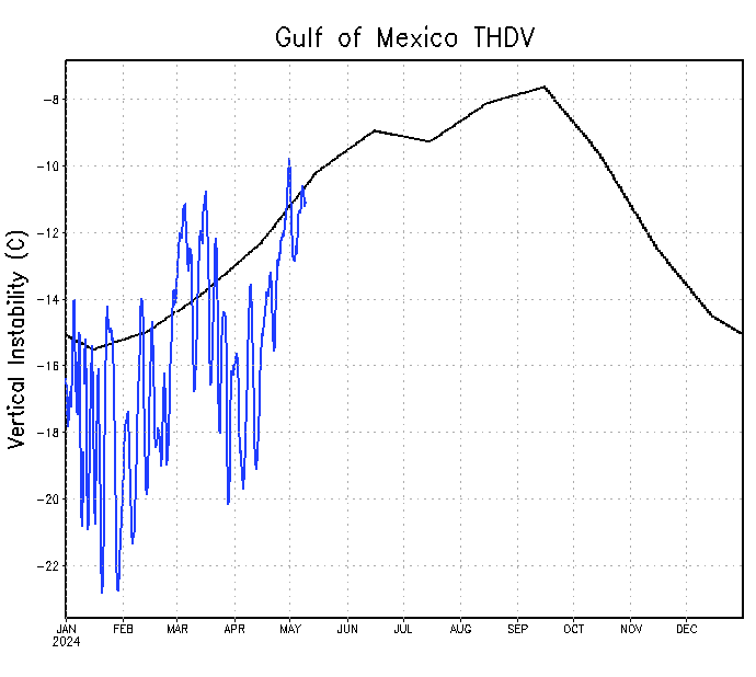
https://www.ssd.noaa.gov/PS/TROP/TCFP/data/current/ts_al_gmx_THDV.gif
https://www.ssd.noaa.gov/PS/TROP/TCFP/atlantic.html
https://www.cpc.ncep.noaa.gov/products/precip/CWlink/pna/nao.gefs.sprd2.png
https://www.cpc.ncep.noaa.gov/products/ ... /nao.shtml
https://www.aoml.noaa.gov/phod/cyclone/data/
https://cyclonicwx.com/data/sst/crw_ssta_natl.png
https://cyclonicwx.com/data/sst/crw_ssta_tropatl.png
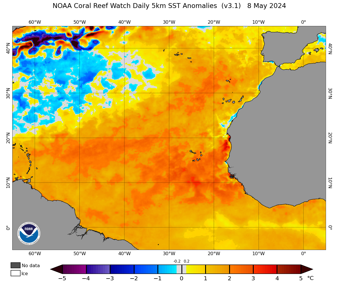
https://coralreefwatch.noaa.gov/data_current/5km/v3.1_op/daily/png/ct5km_ssta_v3.1_nwel_current.png
https://cyclonicwx.com/data/sst/ssta_natl.png
https://cyclonicwx.com/data/sst/ssta_tropatl.png
https://cyclonicwx.com/data/sst/ssta_change_natl.png
https://cyclonicwx.com/data/sst/ssta_change_tropatl.png
https://cyclonicwx.com/sst/
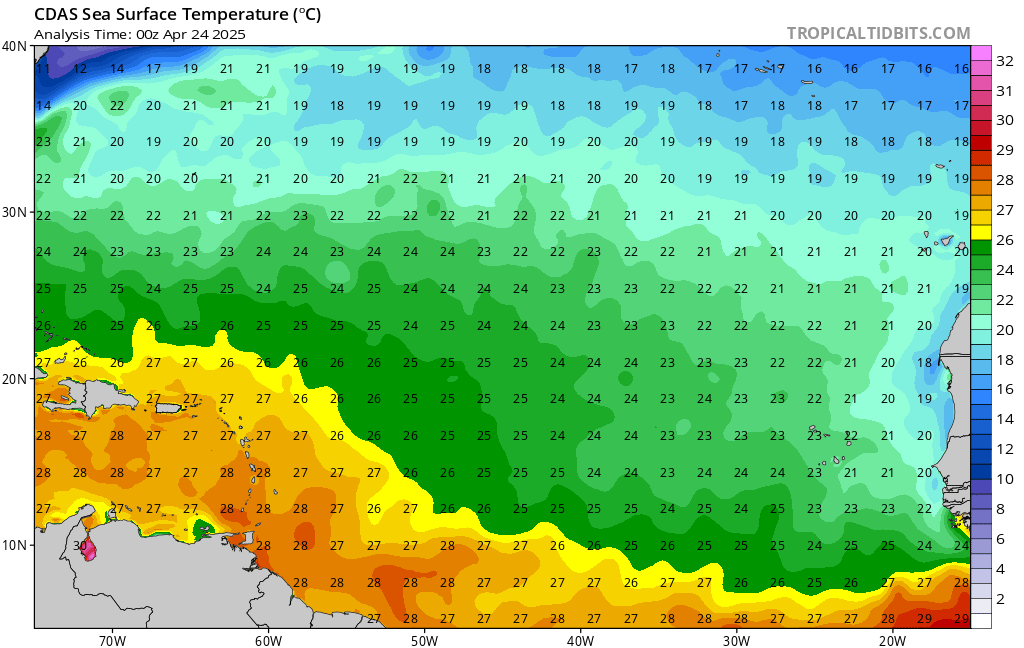
https://www.tropicaltidbits.com/analysis/ocean/cdas-sflux_sst_atl_1.png
https://www.tropicaltidbits.com/analysis/ocean/cdas-sflux_sst_eatl_1.png
https://www.tropicaltidbits.com/analysis/ocean/cdas-sflux_sst_watl_1.png
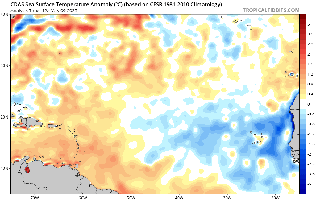
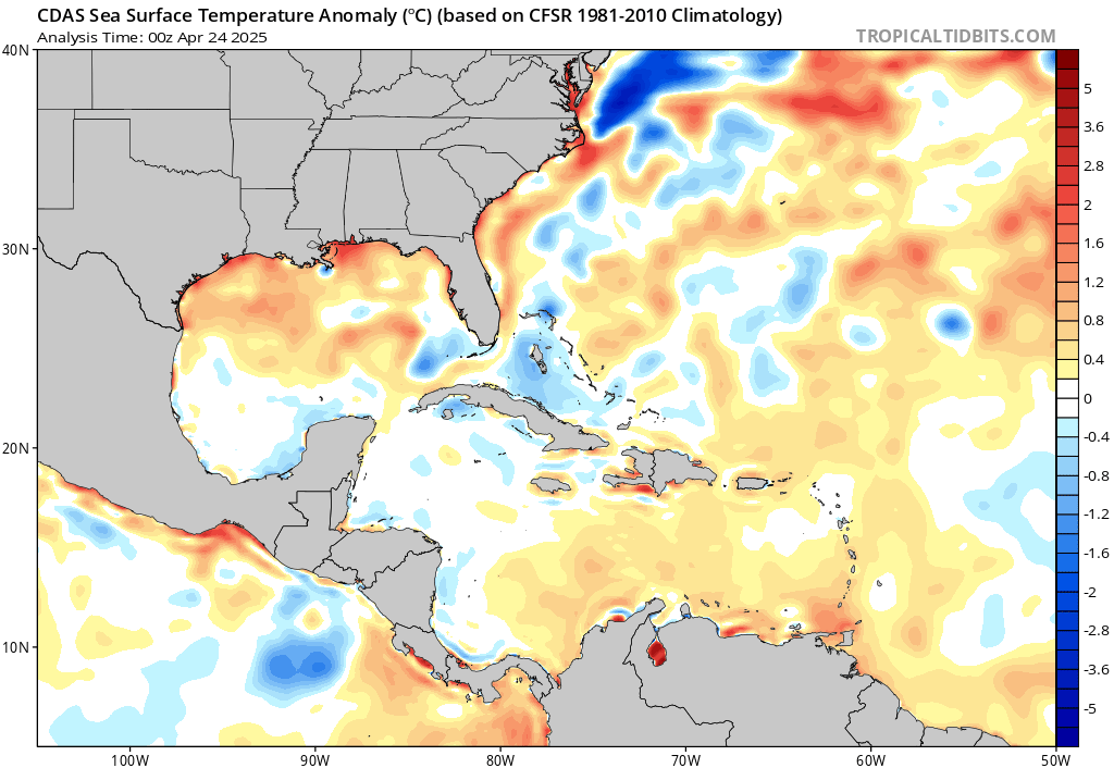
https://www.tropicaltidbits.com/analysis/ocean/cdas-sflux_ssta_atl_1.png
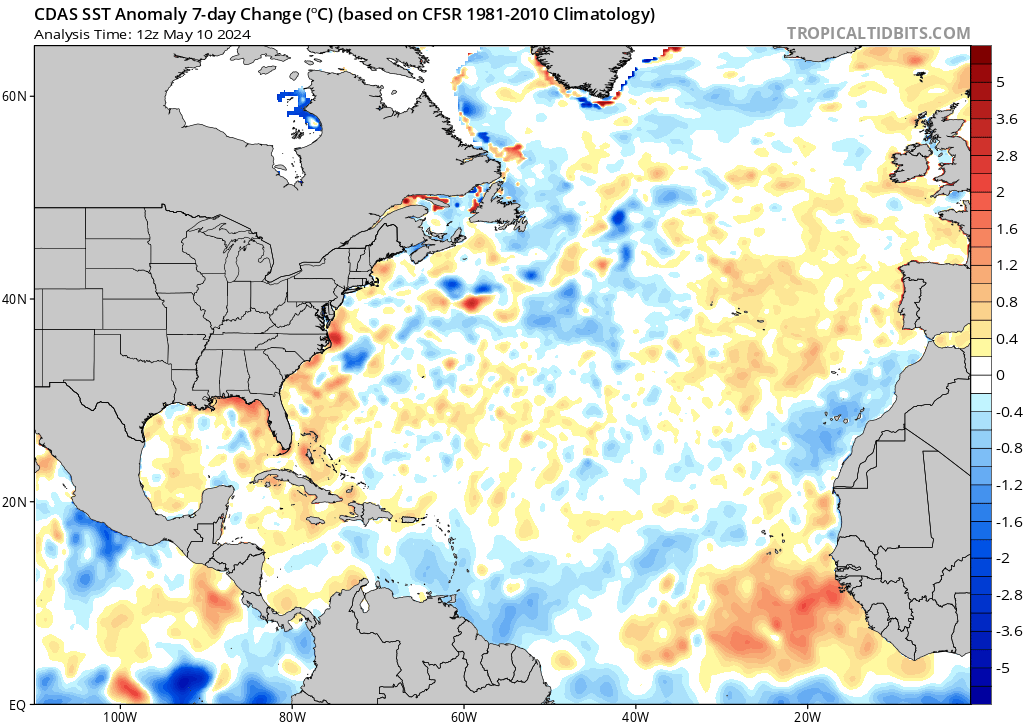
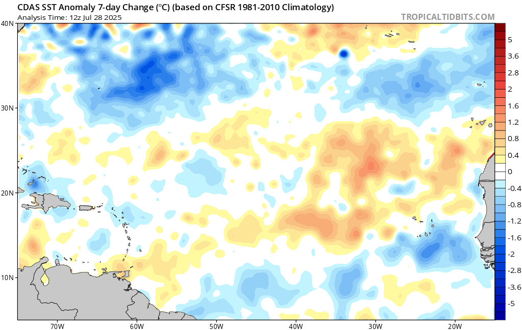
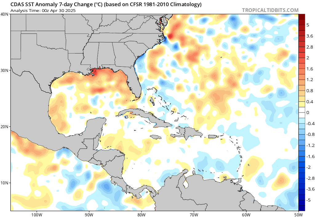
https://www.tropicaltidbits.com/analysis/ocean/cdas-sflux_ssta7diff_atl_1.png
https://www.tropicaltidbits.com/analysis/ocean/cdas-sflux_ssta_eatl_1.png
https://www.tropicaltidbits.com/analysis/ocean/cdas-sflux_ssta7diff_eatl_1.png
https://www.tropicaltidbits.com/analysis/ocean/cdas-sflux_ssta_watl_1.png
https://www.tropicaltidbits.com/analysis/ocean/cdas-sflux_ssta7diff_watl_1.png
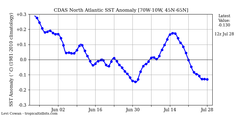
https://www.tropicaltidbits.com/analysis/ocean/natlssta.png
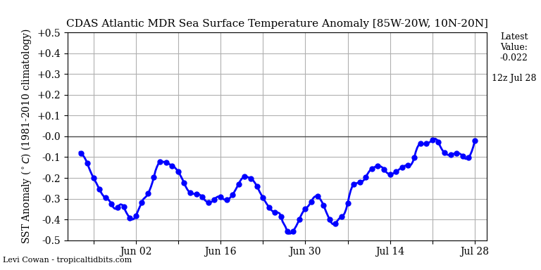
https://www.tropicaltidbits.com/analysis/ocean/mdrssta.png
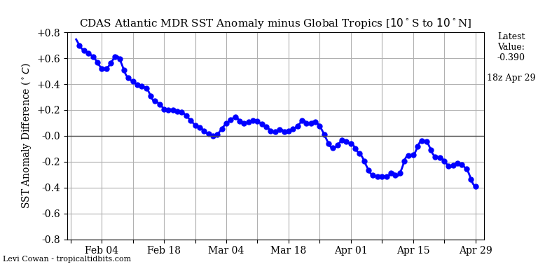
https://www.tropicaltidbits.com/analysis/ocean/mdrglob.png
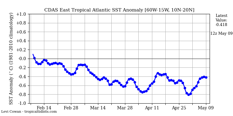
https://www.tropicaltidbits.com/analysis/ocean/eatlssta.png
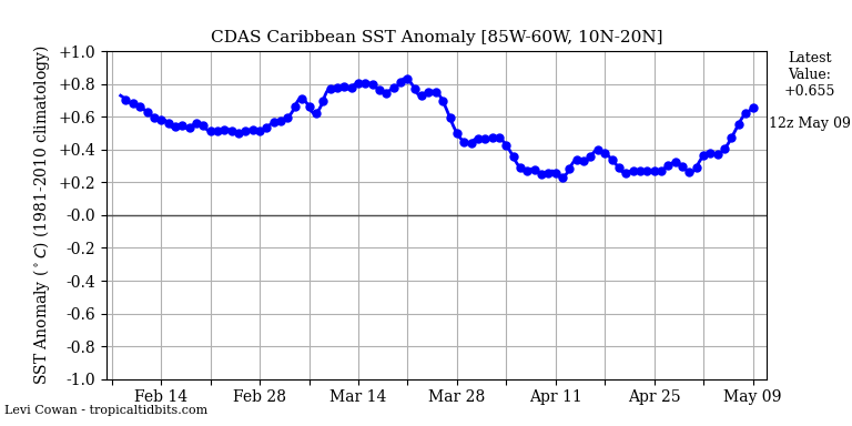
https://www.tropicaltidbits.com/analysis/ocean/carssta.png
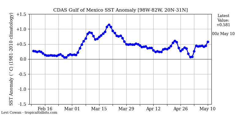
https://www.tropicaltidbits.com/analysis/ocean/gomssta.png
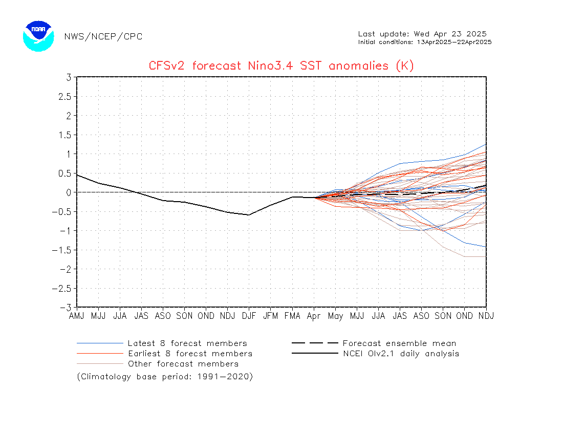
https://www.tropicaltidbits.com/analysis/ocean/nino34.png
https://www.tropicaltidbits.com/analysis/ocean/
http://tropic.ssec.wisc.edu/real-time/sal/splitE.jpg
https://tropic.ssec.wisc.edu/real-time/ ... plit&time=
https://cdn.star.nesdis.noaa.gov/GOES16/ABI/SECTOR/taw/GEOCOLOR/1800x1080.jpg
https://cdn.star.nesdis.noaa.gov/GOES16/ABI/SECTOR/taw/13/1800x1080.jpg
https://cdn.star.nesdis.noaa.gov/GOES16/ABI/SECTOR/pr/GEOCOLOR/1200x1200.jpg
https://cdn.star.nesdis.noaa.gov/GOES16/ABI/SECTOR/pr/13/600x600.jpg
https://cdn.star.nesdis.noaa.gov/GOES16/ABI/SECTOR/car/GEOCOLOR/1000x1000.jpg
https://cdn.star.nesdis.noaa.gov/GOES16/ABI/SECTOR/car/13/1000x1000.jpg
https://cdn.star.nesdis.noaa.gov/GOES16/ABI/SECTOR/gm/GEOCOLOR/1000x1000.jpg
https://cdn.star.nesdis.noaa.gov/GOES16/ABI/SECTOR/gm/13/1000x1000.jpg
https://cdn.star.nesdis.noaa.gov/GOES16/ABI/SECTOR/eus/GEOCOLOR/1000x1000.jpg
https://cdn.star.nesdis.noaa.gov/GOES16/ABI/SECTOR/eus/13/1000x1000.jpg
ECMWF MSLP Updates


