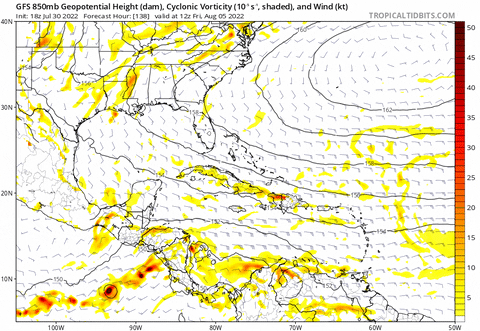
2022 Indicators (SSTs/SAL/MSLP/Shear/Steering/Instability) and >Day 16 Models

This is the general tropical discussion area. Anyone can take their shot at predicting a storms path.

Moderator: S2k Moderators

Forum rules

The posts in this forum are NOT official forecasts and should not be used as such. They are just the opinion of the poster and may or may not be backed by sound meteorological data. They are NOT endorsed by any professional institution or STORM2K. For official information, please refer to products from the National Hurricane Center and National Weather Service.

Help Support Storm2K
Message
Author
User avatar
weeniepatrol
Category 5
Category 5
Posts: 1276
Joined: Sat Aug 22, 2020 5:30 pm
Location: WA State

Re: 2022 Indicators (SSTs/SAL/MSLP/Shear/Steering/Instability) and >Day 16 Models

#2301 Postby weeniepatrol » Sat Jul 30, 2022 9:13 pm

skyline385 wrote:Looks like a decently large eddy has also recently broken off from the loop current in the center of the Gulf as well. These eddies breaking off and camping are particularly dangerous and have been responsible for the bombing of Katrina, Rita and Ida amongst others.

https://i.imgur.com/Bpi5aaq.png

https://i.imgur.com/Y8qhpKb.png


I love how evident the effects of southern Caribbean trade wind divergence are. That gradient goes from 100 to near 0 kj/cm² over just a few degrees of latitude!! :lol:
1 likes   

User avatar
Hammy
Category 5
Category 5
Posts: 5849
Age: 42
Joined: Fri May 25, 2012 5:25 pm
Contact:

Re: 2022 Indicators (SSTs/SAL/MSLP/Shear/Steering/Instability) and >Day 16 Models

#2302 Postby Hammy » Sat Jul 30, 2022 10:04 pm

Category5Kaiju wrote:
Teban54 wrote:
aspen wrote:You’d think the models would be showing unambiguous signs of life in the long-range (I’m guessing that GEFS WCar storm is Phantom #67261 this year) and the 2013 comments would be on the decline, but nope.

This didn't age well :lol:


It's one thing if it's May or June.

It's a completely different story when it's August, especially during a period when the favorable velocity pattern phase should set in, and when the GoM has an extremely pronounced LC as well as 29-30 and in some isolated places 31 C skin temperatures.

While we have yet to see what will really unfold by then and if other models hop on, I have a feeling that this could be that moment where the GFS, having given false alarms in the W. Atlantic throughout the past several months, finally gets it right.


Always be wary of GFS storms 300+ hours out, especially in the Caribbean where it always amplifies the monsoon trough and also has a north bias with it. In all likelihood, whenever the next storm develops we won't see it coming more than week out.
4 likes   
The above post is not official and should not be used as such. It is the opinion of the poster and may or may not be backed by sound meteorological data. It is not endorsed by any professional institution or storm2k.org. For official information, please refer to the NHC and NWS products.

zzh
Category 1
Category 1
Posts: 375
Joined: Fri Aug 27, 2021 2:18 pm

Re: 2022 Indicators (SSTs/SAL/MSLP/Shear/Steering/Instability) and >Day 16 Models

#2303 Postby zzh » Sat Jul 30, 2022 10:15 pm

https://journals.ametsoc.org/view/journals/mwre/145/5/mwr-d-16-0411.1.xml
Image
ZERO CAG event was identified in July and August.
1 likes   

User avatar
skyline385
Category 5
Category 5
Posts: 2728
Age: 35
Joined: Wed Aug 26, 2020 11:15 pm
Location: Houston TX

Re: 2022 Indicators (SSTs/SAL/MSLP/Shear/Steering/Instability) and >Day 16 Models

#2304 Postby skyline385 » Sat Jul 30, 2022 10:25 pm


Happy hour GFS still finds a way to setup a Gyre (you can see it travel northwards along CA) and spawn two systems off it, one in the EPAC and other eventually in the Gulf :D

Image
1 likes   

LarryWx
S2K Supporter
S2K Supporter
Posts: 6326
Joined: Sun Sep 07, 2003 2:04 pm
Location: GA

Re: 2022 Indicators (SSTs/SAL/MSLP/Shear/Steering/Instability) and >Day 16 Models

#2305 Postby LarryWx » Sat Jul 30, 2022 10:44 pm

Comparing 2022 to 3rd year ENSO analogs:

1. Date of 3rd NS
2022: 7/2 (earlier than all 8 analogs)
2000: 8/17
1985: 8/9
1975: 8/24
1956: 7/25..this was only analog season with 3 NS as of now just like 2022
1917: 8/30
1910: 9/5
1894: 8/30
1874: 8/28

2. 1st MDR storm
2022: 7/1 (earlier than all 8 analogs)
2000: 8/3
1985: 8/12
1975: 9/13
1956: 8/9
1917: 7/6
1910: 8/23
1894: 8/30
1874: 8/28

3. 1st MH
2022: very likely after 8/7
2000: 8/11
1985: 8/30
1975: 8/30
1956: 8/9 (earliest)
1917: 8/30
1910: 10/11
1894: 9/1 (this year had highest ACE of analogs with 135)
1874: no MH
0 likes   
Personal Forecast Disclaimer:
The posts in this forum are NOT official forecasts and should not be used as such. They are just the opinion of the poster and may or may not be backed by sound meteorological data. They are NOT endorsed by any professional institution or storm2k.org. For official information, please refer to the NHC and NWS products.

User avatar
skyline385
Category 5
Category 5
Posts: 2728
Age: 35
Joined: Wed Aug 26, 2020 11:15 pm
Location: Houston TX

Re: 2022 Indicators (SSTs/SAL/MSLP/Shear/Steering/Instability) and >Day 16 Models

#2306 Postby skyline385 » Sun Jul 31, 2022 1:28 am

Made a little loop showing the Eddy in the Gulf split off from the Loop current.

Image
4 likes   

User avatar
ThomasW
Tropical Depression
Tropical Depression
Posts: 78
Age: 44
Joined: Thu May 19, 2022 10:59 am
Contact:

Re: 2022 Indicators (SSTs/SAL/MSLP/Shear/Steering/Instability) and >Day 16 Models

#2307 Postby ThomasW » Sun Jul 31, 2022 7:13 am

With the GFS showing continued atmospheric wavebreaking in the subtropics, pushing massive amounts of dry air into the MDR, prospects for an above average season this year are starting to look dim at best. No waves are able to cross the MDR intact as a result of this pattern. No MDR invests in the last month. Not a hint at genuine TCG from models up to TAUU 384. This isn't your "normal lull". This is what a below average season looks like. If the Atlantic is lucky, it can squeeze in a couple stronger homegrown storms in September and October. But the MDR looks dead for the foreseeable future (up to the end of August). The only hope for above average activity is the CFS/ECMWF solution playing out, but with the biases of those models that feels unlikely. Feels like 2007 in a way, likely without Dean and possibly Felix too. I expect fully to see CSU, etc drop their forecasts massively on August 20 when Danielle hasn't formed by then.
0 likes   

MHC Tracking
Tropical Storm
Tropical Storm
Posts: 195
Joined: Mon Mar 15, 2021 10:05 am

Re: 2022 Indicators (SSTs/SAL/MSLP/Shear/Steering/Instability) and >Day 16 Models

#2308 Postby MHC Tracking » Sun Jul 31, 2022 7:16 am

ThomasW wrote:With the GFS showing continued atmospheric wavebreaking in the subtropics, pushing massive amounts of dry air into the MDR, prospects for an above average season this year are starting to look dim at best. No waves are able to cross the MDR intact as a result of this pattern. No MDR invests in the last month. Not a hint at genuine TCG from models up to TAUU 384. This isn't your "normal lull". This is what a below average season looks like. If the Atlantic is lucky, it can squeeze in a couple stronger homegrown storms in September and October. But the MDR looks dead for the foreseeable future (up to the end of August). The only hope for above average activity is the CFS/ECMWF solution playing out, but with the biases of those models that feels unlikely. Feels like 2007 in a way, likely without Dean and possibly Felix too. I expect fully to see CSU, etc drop their forecasts massively on August 20 when Danielle hasn't formed by then.

Has the GFS been reliable this season? Far from it. +, why are you taking long-range model output as verbatim? This post reeks of impatience and acidic bustcasting.
:spam:
10 likes   

User avatar
ElectricStorm
Category 5
Category 5
Posts: 5051
Age: 24
Joined: Tue Aug 13, 2019 11:23 pm
Location: Skiatook, OK / Norman, OK

Re: 2022 Indicators (SSTs/SAL/MSLP/Shear/Steering/Instability) and >Day 16 Models

#2309 Postby ElectricStorm » Sun Jul 31, 2022 7:33 am

ThomasW wrote:With the GFS showing continued atmospheric wavebreaking in the subtropics, pushing massive amounts of dry air into the MDR, prospects for an above average season this year are starting to look dim at best. No waves are able to cross the MDR intact as a result of this pattern. No MDR invests in the last month. Not a hint at genuine TCG from models up to TAUU 384. This isn't your "normal lull". This is what a below average season looks like. If the Atlantic is lucky, it can squeeze in a couple stronger homegrown storms in September and October. But the MDR looks dead for the foreseeable future (up to the end of August). The only hope for above average activity is the CFS/ECMWF solution playing out, but with the biases of those models that feels unlikely. Feels like 2007 in a way, likely without Dean and possibly Felix too. I expect fully to see CSU, etc drop their forecasts massively on August 20 when Danielle hasn't formed by then.

Bruh :spam:

It's literally July 31st...

I just don't understand how people seem to always trust a 384 hr model run when it shows nothing, even though it's just as unreliable as when it shows a major hurricane that far out.

:spam: :spam:

If we get to September and it's still like this then we can talk but that's highly unlikely
Last edited by ElectricStorm on Sun Jul 31, 2022 9:23 am, edited 1 time in total.
9 likes   
B.S Meteorology, University of Oklahoma '25

Please refer to the NHC, NWS, or SPC for official information.

User avatar
cycloneye
Admin
Admin
Posts: 145484
Age: 68
Joined: Thu Oct 10, 2002 10:54 am
Location: San Juan, Puerto Rico

Re: 2022 Indicators (SSTs/SAL/MSLP/Shear/Steering/Instability) and >Day 16 Models

#2310 Postby cycloneye » Sun Jul 31, 2022 8:14 am

0 likes   
Visit the Caribbean-Central America Weather Thread where you can find at first post web cams,radars
and observations from Caribbean basin members Click Here

User avatar
NDG
S2K Supporter
S2K Supporter
Posts: 15446
Joined: Sun Jul 09, 2006 10:14 pm
Location: Orlando, FL

Re: 2022 Indicators (SSTs/SAL/MSLP/Shear/Steering/Instability) and >Day 16 Models

#2311 Postby NDG » Sun Jul 31, 2022 8:18 am

ThomasW wrote:With the GFS showing continued atmospheric wavebreaking in the subtropics, pushing massive amounts of dry air into the MDR, prospects for an above average season this year are starting to look dim at best. No waves are able to cross the MDR intact as a result of this pattern. No MDR invests in the last month. Not a hint at genuine TCG from models up to TAUU 384. This isn't your "normal lull". This is what a below average season looks like. If the Atlantic is lucky, it can squeeze in a couple stronger homegrown storms in September and October. But the MDR looks dead for the foreseeable future (up to the end of August). The only hope for above average activity is the CFS/ECMWF solution playing out, but with the biases of those models that feels unlikely. Feels like 2007 in a way, likely without Dean and possibly Felix too. I expect fully to see CSU, etc drop their forecasts massively on August 20 when Danielle hasn't formed by then.


If today would have been mid to late August instead of July 31st I would have agreed with you about looking like a below average season so far.
By no ways this is looking like a hyperactive season in the making but to say it will be a below average or even an average season is way too soon to say, IMO.
1 likes   

User avatar
SFLcane
S2K Supporter
S2K Supporter
Posts: 10163
Age: 47
Joined: Sat Jun 05, 2010 1:44 pm
Location: Lake Worth Florida

Re: 2022 Indicators (SSTs/SAL/MSLP/Shear/Steering/Instability) and >Day 16 Models

#2312 Postby SFLcane » Sun Jul 31, 2022 8:53 am

I honestly don’t expect much reduction in Phil K’s numbers on Tuesday the sst profile is still rather similar to his last outlook and though not perfect has the look of an active season.

Image

Image
0 likes   

User avatar
Category5Kaiju
Category 5
Category 5
Posts: 4103
Joined: Thu Dec 24, 2020 12:45 pm
Location: Seattle

Re: 2022 Indicators (SSTs/SAL/MSLP/Shear/Steering/Instability) and >Day 16 Models

#2313 Postby Category5Kaiju » Sun Jul 31, 2022 9:04 am

ThomasW wrote:With the GFS showing continued atmospheric wavebreaking in the subtropics, pushing massive amounts of dry air into the MDR, prospects for an above average season this year are starting to look dim at best. No waves are able to cross the MDR intact as a result of this pattern. No MDR invests in the last month. Not a hint at genuine TCG from models up to TAUU 384. This isn't your "normal lull". This is what a below average season looks like. If the Atlantic is lucky, it can squeeze in a couple stronger homegrown storms in September and October. But the MDR looks dead for the foreseeable future (up to the end of August). The only hope for above average activity is the CFS/ECMWF solution playing out, but with the biases of those models that feels unlikely. Feels like 2007 in a way, likely without Dean and possibly Felix too. I expect fully to see CSU, etc drop their forecasts massively on August 20 when Danielle hasn't formed by then.


But….it’s only July 31 :D

Not to mention we have a solid La Niña, a warm MDR (something 2007 seriously lacked), and a -PDO. If this season busts, then that would literally defy everything we have known about what general conditions would favor Atlantic activity.
4 likes   
Unless explicitly stated, all info in my posts is based on my own opinions and observations. Tropical storms and hurricanes can be extremely dangerous. Do not think you can beat Mother Nature. Refer to an accredited weather research agency or meteorologist if you need to make serious decisions regarding an approaching storm.

User avatar
Category5Kaiju
Category 5
Category 5
Posts: 4103
Joined: Thu Dec 24, 2020 12:45 pm
Location: Seattle

Re: 2022 Indicators (SSTs/SAL/MSLP/Shear/Steering/Instability) and >Day 16 Models

#2314 Postby Category5Kaiju » Sun Jul 31, 2022 9:09 am

SFLcane wrote:I honestly don’t expect much reduction in Phil K’s numbers on Tuesday the sst profile is still rather similar to his last outlook and though not perfect has the look of an active season.

https://i.postimg.cc/1Xhrj5b5/82135422-5042-4-BF1-8-B7-E-910-EFADBC5-A8.png

https://i.postimg.cc/cCRByGN7/0612-F1-B1-7-FC8-40-DA-9381-68-BD4-AB53-DAF.png


If this season busts, then imagine how useless the idea of “La Nina” and “warm MDR” will become in future forecasts for hurricane seasons. :lol:
4 likes   
Unless explicitly stated, all info in my posts is based on my own opinions and observations. Tropical storms and hurricanes can be extremely dangerous. Do not think you can beat Mother Nature. Refer to an accredited weather research agency or meteorologist if you need to make serious decisions regarding an approaching storm.

tolakram
Admin
Admin
Posts: 20012
Age: 62
Joined: Sun Aug 27, 2006 8:23 pm
Location: Florence, KY (name is Mark)

Re: 2022 Indicators (SSTs/SAL/MSLP/Shear/Steering/Instability) and >Day 16 Models

#2315 Postby tolakram » Sun Jul 31, 2022 9:50 am

ThomasW wrote:With the GFS showing continued atmospheric wavebreaking in the subtropics, pushing massive amounts of dry air into the MDR, prospects for an above average season this year are starting to look dim at best. No waves are able to cross the MDR intact as a result of this pattern. No MDR invests in the last month. Not a hint at genuine TCG from models up to TAUU 384. This isn't your "normal lull". This is what a below average season looks like. If the Atlantic is lucky, it can squeeze in a couple stronger homegrown storms in September and October. But the MDR looks dead for the foreseeable future (up to the end of August). The only hope for above average activity is the CFS/ECMWF solution playing out, but with the biases of those models that feels unlikely. Feels like 2007 in a way, likely without Dean and possibly Felix too. I expect fully to see CSU, etc drop their forecasts massively on August 20 when Danielle hasn't formed by then.


Atmospheric wave breaking and not a normal lull? Not sure what you mean there.
3 likes   
M a r k
- - - - -
Join us in chat: Storm2K Chatroom Invite. Android and IOS apps also available.

The posts in this forum are NOT official forecasts and should not be used as such. Posts are NOT endorsed by any professional institution or STORM2K.org. For official information and forecasts, please refer to NHC and NWS products.

User avatar
Spacecoast
Category 2
Category 2
Posts: 758
Joined: Thu Aug 31, 2017 2:03 pm

Re: 2022 Indicators (SSTs/SAL/MSLP/Shear/Steering/Instability) and >Day 16 Models

#2316 Postby Spacecoast » Sun Jul 31, 2022 10:09 am

NDG wrote:
ThomasW wrote:With the GFS showing continued atmospheric wavebreaking in the subtropics, pushing massive amounts of dry air into the MDR, prospects for an above average season this year are starting to look dim at best. No waves are able to cross the MDR intact as a result of this pattern. No MDR invests in the last month. Not a hint at genuine TCG from models up to TAUU 384. This isn't your "normal lull". This is what a below average season looks like. If the Atlantic is lucky, it can squeeze in a couple stronger homegrown storms in September and October. But the MDR looks dead for the foreseeable future (up to the end of August). The only hope for above average activity is the CFS/ECMWF solution playing out, but with the biases of those models that feels unlikely. Feels like 2007 in a way, likely without Dean and possibly Felix too. I expect fully to see CSU, etc drop their forecasts massively on August 20 when Danielle hasn't formed by then.


If today would have been mid to late August instead of July 31st I would have agreed with you about looking like a below average season so far.
By no ways this is looking like a hyperactive season in the making but to say it will be a below average or even an average season is way too soon to say, IMO.


My amateurish thoughts.
categorizing seasons into nine types, (in terms of distribution / activity):

Front loaded season, hyperactivity level
Front loaded season, normal activity level: -Looking less likely
Front loaded season, tepid activity level: -Possible, not likely (La Niña)

Normal distribution, hyperactivity level: -looking less likely?
Normal distribution, normal activity level: -Possible
Normal distribution, tepid activity level: -Not likely, due to La Niña


Back loaded season, hyperactivity level: -Possible. -Too early to tell
Back loaded season, normal activity level: -Possible, (maybe looking more likely). -Too early to tell
Back loaded season, tepid activity level: -Possible. -Not likely?(La Niña). Too early to tell.

It may be safe to say that 2022 will not be a front loaded, hyper season.
Everything else is still on the table, IMHO.

Perhaps 2022 will be a back loaded season, with just 'above average' activity .

note: "average" activity depends on how far back you go. ...
CSU uses 1991-2020 (14.4 NS/ 7.2 Hurr / 3.2 MH), but there are others:
1950-2021 (11.8 NS/ 6.4 Hurr / 2.8 MH)
1851-2021 (9.7 NS/ 5.5 Hurr / 2.0 MH)
Last edited by Spacecoast on Sun Jul 31, 2022 11:00 am, edited 2 times in total.
1 likes   

User avatar
Category5Kaiju
Category 5
Category 5
Posts: 4103
Joined: Thu Dec 24, 2020 12:45 pm
Location: Seattle

Re: 2022 Indicators (SSTs/SAL/MSLP/Shear/Steering/Instability) and >Day 16 Models

#2317 Postby Category5Kaiju » Sun Jul 31, 2022 10:18 am

I've been recently reading the 2019 sst indicators thread for fun, and I gotta admit, I cannot see how this year is any different from the lull and attitudes that were seen in that year around this time. They're very similar- dry air, models unenthusiastic, doubts about an active year...

Then again, for this year (which, unlike 2013 or 2019, is a true La Nina with a cool subtropics and above average MDR) to bust tremendously would be extremely weird. I mean, EXTREMELY weird. :lol:
0 likes   
Unless explicitly stated, all info in my posts is based on my own opinions and observations. Tropical storms and hurricanes can be extremely dangerous. Do not think you can beat Mother Nature. Refer to an accredited weather research agency or meteorologist if you need to make serious decisions regarding an approaching storm.

User avatar
skyline385
Category 5
Category 5
Posts: 2728
Age: 35
Joined: Wed Aug 26, 2020 11:15 pm
Location: Houston TX

Re: 2022 Indicators (SSTs/SAL/MSLP/Shear/Steering/Instability) and >Day 16 Models

#2318 Postby skyline385 » Sun Jul 31, 2022 10:52 am

SFLcane wrote:I honestly don’t expect much reduction in Phil K’s numbers on Tuesday the sst profile is still rather similar to his last outlook and though not perfect has the look of an active season.

https://i.postimg.cc/1Xhrj5b5/82135422-5042-4-BF1-8-B7-E-910-EFADBC5-A8.png

https://i.postimg.cc/cCRByGN7/0612-F1-B1-7-FC8-40-DA-9381-68-BD4-AB53-DAF.png


That plot was Phil's correlation with SSTs at the beginning of July, the August correlation is slightly different. Phil also uses a 14-day SSTa average in his forecasts so here's a composite comparing August correlation to 14-day SSTa, its not all ideal (also usual disclaimer that SSTs aren't everything).
Also, wxman lowered his numbers by 3/1/1 and said its likely Phil will lower his numbers as well.

Image
1 likes   

User avatar
AnnularCane
S2K Supporter
S2K Supporter
Posts: 2864
Joined: Thu Jun 08, 2006 9:18 am
Location: Wytheville, VA

Re: 2022 Indicators (SSTs/SAL/MSLP/Shear/Steering/Instability) and >Day 16 Models

#2319 Postby AnnularCane » Sun Jul 31, 2022 11:03 am

Category5Kaiju wrote:I've been recently reading the 2019 sst indicators thread for fun, and I gotta admit, I cannot see how this year is any different from the lull and attitudes that were seen in that year around this time. They're very similar- dry air, models unenthusiastic, doubts about an active year...

Then again, for this year (which, unlike 2013 or 2019, is a true La Nina with a cool subtropics and above average MDR) to bust tremendously would be extremely weird. I mean, EXTREMELY weird. :lol:


I'm looking at the indicators thread from 2017 right now. If I may post a few comments that were posted in late July that year:

Scorpion:
Starting to remind me of 2013 here. All the discussion was very similar, just wait until August. Seeing nothing in the models at long range is alarming. Still think we might see a threat or two in September and October but doesn't seem to be an active season coming.


SFLcane:
Boy... a threat or two in August maybe September? Guys we are still in " JULY " nothing in the long range models I mean come on every year it's the same season over talk only for things to explode 2-3 week of aug. Nothing looks like 2013 one thing which has concern is all that heat focused in the main development region with cold ssts to the north ( horse shoe config) spells trouble when the real season starts. Abviously plenty other factors to consider but the one I just mentioned is what sticks out for me. Also shear has been below normal across the central and eastern Atlantic for weeks now. Just let things play out before you know it this forum will be lighting up at all hrs.

Can't wait! :cheesy:


Gatorcane:
To summarize some of the key points discussed in this thread as of late:

1. July is climatologically an unfavorable month for development across the Atlantic so it is really difficult to use this month's indicators to make any prediction for peak hurricane season months. SAL, shear, TUTTs are all usually ubiquitous across the basin this month.

2. The GFS has shown it is much more conservative in the deep Atlantic MDR than the previous GFS - seems more similar to the ECMWF now which was always on the conservative side - this could mean we may not always get as much notice of tropical development as we have gotten in the past. Could be more like less than a week (3-5 days?) than a week or later.

3. Active seasons do not necessarily need to start in July or even early August in fact many active seasons did not start getting going until late August.

4. We are just about ready to start the steep ramp in climatologically favored hurricane activity which peaks Sept 10th so not a surprise thing are still slow now - we would expect conditions to gradually improve from here on out but particularly after Aug 15th.

5. Indicators suggest this season is not comparable to 2013 (much less active than expected) or 2005 (much more active than expected).


TheStormExpert:
Yeah I thought that Nor'easter seemed quite off. This very well could be a bad sign for those (like me) hoping for an active Atlantic hurricane season. If in 2 weeks the models still show zilch 10-16 days out I'm willing to call it season cancel especially if the pattern starts changing to more of a fall/winter type pattern.


And I haven't even gotten to the August posts yet! :cheesy:
7 likes   
"But it never rained rain. It never snowed snow. And it never blew just wind. It rained things like soup and juice. It snowed mashed potatoes and green peas. And sometimes the wind blew in storms of hamburgers." -- Judi Barrett, Cloudy with a Chance of Meatballs

User avatar
WiscoWx02
Category 1
Category 1
Posts: 391
Joined: Sat Jul 31, 2021 8:09 pm

Re: 2022 Indicators (SSTs/SAL/MSLP/Shear/Steering/Instability) and >Day 16 Models

#2320 Postby WiscoWx02 » Sun Jul 31, 2022 11:22 am

AnnularCane wrote:
Category5Kaiju wrote:I've been recently reading the 2019 sst indicators thread for fun, and I gotta admit, I cannot see how this year is any different from the lull and attitudes that were seen in that year around this time. They're very similar- dry air, models unenthusiastic, doubts about an active year...

Then again, for this year (which, unlike 2013 or 2019, is a true La Nina with a cool subtropics and above average MDR) to bust tremendously would be extremely weird. I mean, EXTREMELY weird. :lol:


I'm looking at the indicators thread from 2017 right now. If I may post a few comments that were posted in late July that year:

Scorpion:
Starting to remind me of 2013 here. All the discussion was very similar, just wait until August. Seeing nothing in the models at long range is alarming. Still think we might see a threat or two in September and October but doesn't seem to be an active season coming.


SFLcane:
Boy... a threat or two in August maybe September? Guys we are still in " JULY " nothing in the long range models I mean come on every year it's the same season over talk only for things to explode 2-3 week of aug. Nothing looks like 2013 one thing which has concern is all that heat focused in the main development region with cold ssts to the north ( horse shoe config) spells trouble when the real season starts. Abviously plenty other factors to consider but the one I just mentioned is what sticks out for me. Also shear has been below normal across the central and eastern Atlantic for weeks now. Just let things play out before you know it this forum will be lighting up at all hrs.

Can't wait! :cheesy:


Gatorcane:
To summarize some of the key points discussed in this thread as of late:

1. July is climatologically an unfavorable month for development across the Atlantic so it is really difficult to use this month's indicators to make any prediction for peak hurricane season months. SAL, shear, TUTTs are all usually ubiquitous across the basin this month.

2. The GFS has shown it is much more conservative in the deep Atlantic MDR than the previous GFS - seems more similar to the ECMWF now which was always on the conservative side - this could mean we may not always get as much notice of tropical development as we have gotten in the past. Could be more like less than a week (3-5 days?) than a week or later.

3. Active seasons do not necessarily need to start in July or even early August in fact many active seasons did not start getting going until late August.

4. We are just about ready to start the steep ramp in climatologically favored hurricane activity which peaks Sept 10th so not a surprise thing are still slow now - we would expect conditions to gradually improve from here on out but particularly after Aug 15th.

5. Indicators suggest this season is not comparable to 2013 (much less active than expected) or 2005 (much more active than expected).


TheStormExpert:
Yeah I thought that Nor'easter seemed quite off. This very well could be a bad sign for those (like me) hoping for an active Atlantic hurricane season. If in 2 weeks the models still show zilch 10-16 days out I'm willing to call it season cancel especially if the pattern starts changing to more of a fall/winter type pattern.


And I haven't even gotten to the August posts yet! :cheesy:


Look back at the 2016 posts as well for July into early August. Reading back through those a few days back made me kinda depressed…until Matthew came along that is, then the tunes changed.
3 likes   


Return to “Talkin' Tropics”

Who is online

Users browsing this forum: Blown Away, ed, jaguars_22, StormWeather, wwizard and 42 guests