ATL: IAN - Models

Moderator: S2k Moderators

Message
Author
sma10
Category 5
Category 5
Posts: 1709
Joined: Tue Aug 02, 2005 1:13 pm

Re: ATL: INVEST 98L - Models

#81 Postby sma10 » Tue Sep 20, 2022 1:22 pm

MississippiWx wrote:
SFLcane wrote:Updated 12z GEFS even further east.

https://i.postimg.cc/Pxm86h1Y/gefs.png


Looks like the farthest east members went even more to the east. Looks like more spread than before. We have a long way to go with this one.


Yes, long way to go. And attention to the models in short range: no model "blows this up" in the first 72-96 hours. It's not until around Jamaica that we can expect major intensification
0 likes   

Fancy1001
Category 1
Category 1
Posts: 452
Joined: Thu Jul 16, 2020 10:16 pm

Re: ATL: INVEST 98L - Models

#82 Postby Fancy1001 » Tue Sep 20, 2022 1:32 pm

aspen wrote:
Iceresistance wrote:First HWRF weakens this back to a TD because of the Northerly Wind Shear by Fiona.

Pretty much the same as the GFS. This shear ablates in the day 4-5 range as an upper-level anticyclone begins to establish itself over 98L/Hermine. The end of the HWRF run should, in theory, show reorganization and intensification.

Bingo
0 likes   

Frank P
S2K Supporter
S2K Supporter
Posts: 2408
Joined: Fri Aug 29, 2003 10:52 am
Location: Biloxi Beach, Ms

Re: ATL: INVEST 98L - Models

#83 Postby Frank P » Tue Sep 20, 2022 1:34 pm

unless I'm reading this wrong the 12z EURO thru 144h is stronger 995mb, faster and NNW of the 00Z model run at 1005mb.
0 likes   

LarryWx
Category 5
Category 5
Posts: 5703
Joined: Sun Sep 07, 2003 2:04 pm
Location: GA

Re: ATL: INVEST 98L - Models

#84 Postby LarryWx » Tue Sep 20, 2022 1:34 pm

AutoPenalti wrote:
SFLcane wrote:Updated 12z GEFS even further east.

https://i.postimg.cc/Pxm86h1Y/gefs.png

That's weird, the ensembles members are a bit west before SFL...


I thought the same thing. I took another look at the 12Z GEFS members and there are actually more strong members that hit FL north of Tampa vs the prior run. But they do that after hour 240, which doesn't show on this map. Regardless of whether north of Tampa or not, the Gulf coast of FL is the # target of the 12Z GEFS and it looks scary for them overall.
3 likes   
Personal Forecast Disclaimer:
The posts in this forum are NOT official forecasts and should not be used as such. They are just the opinion of the poster and may or may not be backed by sound meteorological data. They are NOT endorsed by any professional institution or storm2k.org. For official information, please refer to the NHC and NWS products.

Frank P
S2K Supporter
S2K Supporter
Posts: 2408
Joined: Fri Aug 29, 2003 10:52 am
Location: Biloxi Beach, Ms

Re: ATL: INVEST 98L - Models

#85 Postby Frank P » Tue Sep 20, 2022 1:38 pm

euro 162h down to 986mb heading for west cuba and dropping
1 likes   

LarryWx
Category 5
Category 5
Posts: 5703
Joined: Sun Sep 07, 2003 2:04 pm
Location: GA

Re: ATL: INVEST 98L - Models

#86 Postby LarryWx » Tue Sep 20, 2022 1:40 pm

It appears to me that the 12Z Euro is headed toward the Gulf coast of FL, similar to the 12Z GEFS target area.
1 likes   
Personal Forecast Disclaimer:
The posts in this forum are NOT official forecasts and should not be used as such. They are just the opinion of the poster and may or may not be backed by sound meteorological data. They are NOT endorsed by any professional institution or storm2k.org. For official information, please refer to the NHC and NWS products.

User avatar
Sambucol
Tropical Storm
Tropical Storm
Posts: 220
Joined: Wed Jul 25, 2007 5:09 pm

Re: ATL: INVEST 98L - Models

#87 Postby Sambucol » Tue Sep 20, 2022 1:40 pm

CrazyC83 wrote:
AutoPenalti wrote:
SFLcane wrote:Updated 12z GEFS even further east.

https://i.postimg.cc/Pxm86h1Y/gefs.png

That's weird, the ensembles members are a bit west before SFL...


That would be because of a strong trough most likely.

Or a bad run?
0 likes   

Frank P
S2K Supporter
S2K Supporter
Posts: 2408
Joined: Fri Aug 29, 2003 10:52 am
Location: Biloxi Beach, Ms

Re: ATL: INVEST 98L - Models

#88 Postby Frank P » Tue Sep 20, 2022 1:44 pm

looks like another FL west gulf coast strike but we'll see shortly..
0 likes   

jhpigott
Category 2
Category 2
Posts: 538
Joined: Wed Jan 02, 2008 8:09 pm
Location: North Palm Beach, Florida

Re: ATL: INVEST 98L - Models

#89 Postby jhpigott » Tue Sep 20, 2022 1:44 pm

12z Euro NE of 00z at hour 192. Looks like it's heading toward FL's Big Bend

https://www.tropicaltidbits.com/analysi ... 92012&fh=6
0 likes   

User avatar
Spacecoast
Category 2
Category 2
Posts: 687
Joined: Thu Aug 31, 2017 2:03 pm

Re: ATL: INVEST 98L - Models

#90 Postby Spacecoast » Tue Sep 20, 2022 1:53 pm

CrazyC83 wrote:
AutoPenalti wrote:
SFLcane wrote:Updated 12z GEFS even further east.

https://i.postimg.cc/Pxm86h1Y/gefs.png

That's weird, the ensembles members are a bit west before SFL...


That would be because of a strong trough most likely.

500-hPA Trough Probability looks like 50%
Image
0 likes   

LarryWx
Category 5
Category 5
Posts: 5703
Joined: Sun Sep 07, 2003 2:04 pm
Location: GA

Re: ATL: INVEST 98L - Models

#91 Postby LarryWx » Tue Sep 20, 2022 1:53 pm

A very dangerous track for Tampa on the 12Z Euro.
2 likes   
Personal Forecast Disclaimer:
The posts in this forum are NOT official forecasts and should not be used as such. They are just the opinion of the poster and may or may not be backed by sound meteorological data. They are NOT endorsed by any professional institution or storm2k.org. For official information, please refer to the NHC and NWS products.

Pelicane
Tropical Depression
Tropical Depression
Posts: 51
Joined: Tue Sep 13, 2022 1:52 pm
Location: Lafayette, Louisiana

Re: ATL: INVEST 98L - Models

#92 Postby Pelicane » Tue Sep 20, 2022 1:53 pm

For some reason tropical tidbits and pivotal weather have a discrepancy at 216 hours. Pivotal drops this to 954 MB.
0 likes   

BobHarlem
Category 5
Category 5
Posts: 1665
Joined: Thu Oct 20, 2005 6:11 pm

Re: ATL: INVEST 98L - Models

#93 Postby BobHarlem » Tue Sep 20, 2022 1:54 pm

Image
3 likes   

User avatar
Steve
S2K Supporter
S2K Supporter
Posts: 8606
Joined: Sat Apr 05, 2003 11:41 pm
Location: Not a state-caster

Re: ATL: INVEST 98L - Models

#94 Postby Steve » Tue Sep 20, 2022 2:05 pm

tarheelprogrammer wrote:I think the models will flip to an East Coast threat in a few days. Ensembles show this as a possibility.


They probably show plenty of possibilities. It could be east coast or Gulf. But when US, EU, German and Canadian all have a major surface low honed in somewhere in the basin in this part of the season that far away, pay attention. It’s more realistic to think there will be low pressure in the Caribbean than to think it’s going to do x or y. 8 or 9 days out, we have no idea - and that assumes something forms (which I’d say is a fairly good bet).
Last edited by Steve on Tue Sep 20, 2022 2:13 pm, edited 1 time in total.
3 likes   

User avatar
Teban54
Category 5
Category 5
Posts: 1958
Joined: Sat May 19, 2018 1:19 pm

Re: ATL: INVEST 98L - Models

#95 Postby Teban54 » Tue Sep 20, 2022 2:11 pm

The 12z Euro is basically a Hurricane Phoenix scenario for Tampa.
1 likes   

User avatar
Steve
S2K Supporter
S2K Supporter
Posts: 8606
Joined: Sat Apr 05, 2003 11:41 pm
Location: Not a state-caster

Re: ATL: INVEST 98L - Models

#96 Postby Steve » Tue Sep 20, 2022 2:12 pm

jhpigott wrote:12z Euro NE of 00z at hour 192. Looks like it's heading toward FL's Big Bend

https://www.tropicaltidbits.com/analysi ... 92012&fh=6


That most likely would be a fading* storm track which is a better scenario than an intensifying one or one that is holding steady.

*unless it comes in south of the Big Bend*
Last edited by Steve on Tue Sep 20, 2022 2:15 pm, edited 1 time in total.
0 likes   

LarryWx
Category 5
Category 5
Posts: 5703
Joined: Sun Sep 07, 2003 2:04 pm
Location: GA

Re: ATL: INVEST 98L - Models

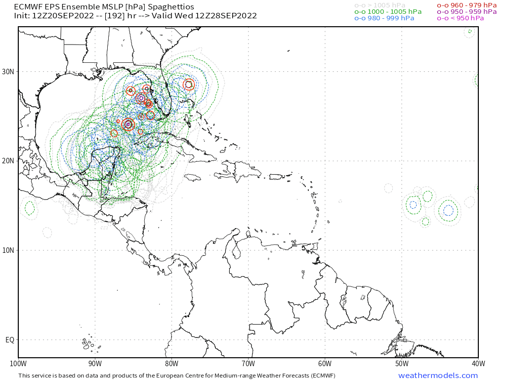
#97 Postby LarryWx » Tue Sep 20, 2022 2:12 pm

The 12Z UKMET at 144 hours is ~200 miles S of the 12Z Euro 144 position, which puts it ~100-150 miles NE of Honduras moving NW. The UKMET is often on the left side of the model consensus mean:


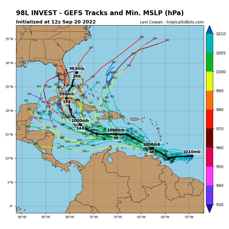
NEW TROPICAL CYCLONE FORECAST TO DEVELOP AFTER 114 HOURS
FORECAST POSITION AT T+114 : 13.9N 76.4W

LEAD CENTRAL MAXIMUM WIND
VERIFYING TIME TIME POSITION PRESSURE (MB) SPEED (KNOTS)
-------------- ---- -------- ------------- -------------
1200UTC 25.09.2022 120 14.2N 77.4W 1004 26
0000UTC 26.09.2022 132 14.6N 79.0W 1003 27
1200UTC 26.09.2022 144 15.6N 80.6W 1002 31
1 likes   
Personal Forecast Disclaimer:
The posts in this forum are NOT official forecasts and should not be used as such. They are just the opinion of the poster and may or may not be backed by sound meteorological data. They are NOT endorsed by any professional institution or storm2k.org. For official information, please refer to the NHC and NWS products.

Stormcenter
S2K Supporter
S2K Supporter
Posts: 6617
Joined: Wed Sep 03, 2003 11:27 am
Location: Houston, TX

Re: ATL: INVEST 98L - Models

#98 Postby Stormcenter » Tue Sep 20, 2022 2:16 pm

I personally don’t get excited about these model runs
until 5 days out. So much can change until we are there.
0 likes   

User avatar
SFLcane
S2K Supporter
S2K Supporter
Posts: 9606
Age: 46
Joined: Sat Jun 05, 2010 1:44 pm
Location: Lake Worth Florida

Re: ATL: INVEST 98L - Models

#99 Postby SFLcane » Tue Sep 20, 2022 2:17 pm

I have this " wilma " type vibe with 98L not so much intensity but track. We shall see

Image
1 likes   

underthwx
Category 5
Category 5
Posts: 1928
Joined: Sat Jul 30, 2011 2:14 pm
Location: Brazoria County Texas

Re: ATL: INVEST 98L - Models

#100 Postby underthwx » Tue Sep 20, 2022 2:22 pm

CrazyC83 wrote:The keys I think are the speed of 98L/Hermine and the trough incoming. There's strong support for a powerful trough coming down around the end of September.


If I may, I agree, with my limited knowledge and understanding, to me it just makes sense, a tropical system responding to the influence of a trough, and moving on a path accordingly, and I feel the models are displaying this.
0 likes   


Return to “2022”

Who is online

Users browsing this forum: No registered users and 15 guests