ATL: IAN - Post-Tropical - Discussion
Moderator: S2k Moderators
-
HurricaneWarning92
- Category 2

- Posts: 519
- Joined: Sat Jul 23, 2011 4:33 pm
- Location: Pembroke Pines, S. Florida (Lat: 26.00N, Lon: 80.22W)
Re: ATL: INVEST 98L - Discussion
Hey guys, long time no post. Been lurking the forums though. I live in Broward. Been watching this wave since day 1. Already alerted my parents to start prepping just in case, because ya never know. Got a BS degree in atmos. science, but you guys have wayy more experience. Love to see everyone’s posts specially SFLcane, Ustropics, of course wxman57, Aric Dunn, GCane, and the list goes on, can’t list everyone  but anyways. This *might* rival Wilma if does hook NE like some of the Euro/ensembles show. But still a little too early to know. Needs to form first. Like you all, interesting days ahead!
1 likes
The posts in this forum are NOT official forecast and should not be used as such. They are just the opinion of the poster and may or may not be backed by sound meteorological data. They are NOT endorsed by any professional institution or storm2k.org. For official information, please refer to the NHC and NWS products.
-
ConvergenceZone
.gif)
- Category 5

- Posts: 4833
- Joined: Fri Jul 29, 2005 1:40 am
- Location: Northern California
Re: ATL: INVEST 98L - Discussion
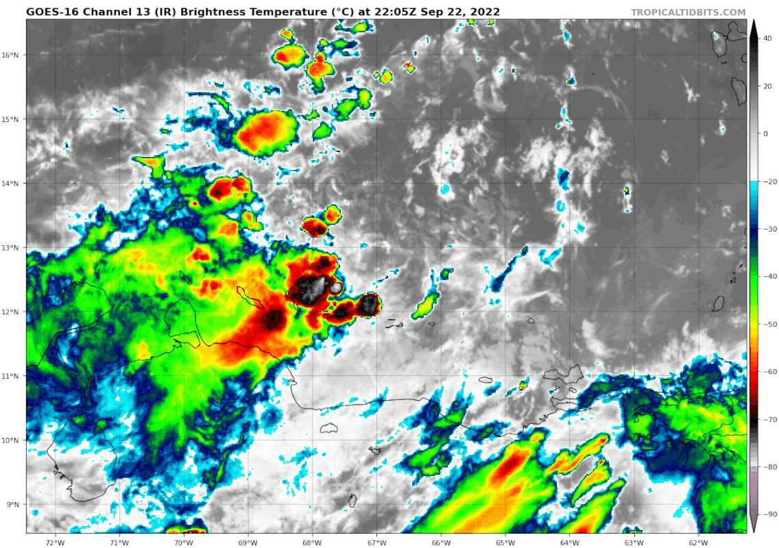
galaxy401 wrote:Finally starting to improve now. Should really start picking up tomorrow.
yep. Convection looking real nice now compared to earlier. Originally I was thinking a depression on Saturday, but based on how it's steadily improving, I'm thinking a depression tomorrow....
0 likes
Re: ATL: INVEST 98L - Discussion
Hurricane Mike wrote:I think the further east this goes, the stronger. If it mills in the Gulf too long interacting with the trough, it'll weaken more prior to landfall. It's also possible further east movement with the trough could allow it to strengthen similar to Charley or Wilma on their approach to Florida.
This was a slight concern based on the early model path projections. A NE landfall direction means the chance exists for a trough to help the storm rather than hinder it.
0 likes

Re: ATL: INVEST 98L - Discussion
Things won't really get hopping at the stores until NHC puts out their 5 day track. Most people aren't like us weather nerds that plan our day for 00z, 06z, 12z, and 18z model runs.
6 likes
-
wxman57

- Moderator-Pro Met

- Posts: 22480
- Age: 66
- Joined: Sat Jun 21, 2003 8:06 pm
- Location: Houston, TX (southwest)
Re: ATL: INVEST 98L - Discussion
Hurricane Mike wrote:I think the further east this goes, the stronger. If it mills in the Gulf too long interacting with the trough, it'll weaken more prior to landfall. It's also possible further east movement with the trough could allow it to strengthen similar to Charley or Wilma on their approach to Florida.
I think the opposite. The farther east it goes, it's because it's encountering strong westerly winds aloft (shear). In addition, it would cut across some tall mountains in Cuba. Might peak east of Florida in that case.
5 likes
-
Category5Kaiju

- Category 5
- Posts: 3351
- Age: 22
- Joined: Thu Dec 24, 2020 12:45 pm
- Location: Seattle
Re: ATL: INVEST 98L - Discussion
TallyTracker wrote:eastcoastFL wrote:IsabelaWeather wrote:
Wilma didn't miss FL to the south either.
Did Wilma turn on a dime? I know she was moving fast but I thought it was always forecast to hit S. Fl
Now Charlie turned on a dime for sure.
Wilma stalled out over Cancun and Cozumel for 36 hours before a very strong front grabbed it a shot the hurricane NE rapidly. This trough won’t be that strong. Wilma was also 3 weeks later in the year. I expect a more gradual turn like Charley or Ivan.
If I am not mistaken, storms that miss Florida to the east despite being in the Caribbean typically happen in late October or November (Cuba 1932 hurricane for example) when troughs really become strong; this trough doesn't seem to really have indications of being that exceptional
1 likes
Unless explicitly stated, all information covered in my posts is based on my opinions and observations. Please refer to a professional meteorologist or an accredited weather research agency otherwise, especially if serious decisions must be made in the event of a potentially life-threatening tropical storm or hurricane.


Re: ATL: INVEST 98L - Discussion
eastcoastFL wrote:IsabelaWeather wrote:cane5 wrote:
Just curious Wilma turned on a dime and quickly what caused that ?
Wilma didn't miss FL to the south either.
Did Wilma turn on a dime? I know she was moving fast but I thought it was always forecast to hit S. Fl
Now Charlie turned on a dime for sure.
I don't remember being surprised by Wilma's arrival as I had put the shutters up the day before. I was surprised by the baroclinic forcing on the backside though, that was unexpected. Charley only surprised me in that it turned right at us, but we had the shutters up for that one too, thank God!
We have a nice giclee canvas photo of the Sanibel lighthouse in our living room. When we bought it a few years ago the shop said that photo was taken the day before Wilma hit. It was a beautiful and serene day.
Last edited by beachnut on Thu Sep 22, 2022 7:40 pm, edited 3 times in total.
3 likes
Elena '85 - Charley '04 - Wilma '05 - Irma '17 - Ian '22 - Idalia '23
-
Poonwalker
- Tropical Storm

- Posts: 146
- Joined: Tue Sep 20, 2022 11:12 am
Re: ATL: INVEST 98L - Discussion
JaxGator wrote:Hey guys, it’s been awhile. Hope everyone is doing well. Watching this one closely. I was thinking that 98L/future Hermine’s potential path “could” be similar to the Cedar Key Hurricane of 1896 (It’s one analog that I could find besides the Tampa Bay Hurricane of 1921). That hurricane did form further north than 98L is currently located, but the path after that once it gets to Jamaica eerily looks similar to some of the more east leaning forecast models atm.
The hurricane also formed on September 22nd and made landfall on September 29th. A hurricane of similar strength and path would not bode well for the folks living on n the Florida West Coast depending on the size. That would bring the dirty side of the hurricane and storm surge up the coast/the peninsula. I pray not. The large scale weather pattern at the time might have been similar too considering the hurricane started to accelerate upon entering the Gulf.
Yeah I checked those two out and both were end of September Canes with very similar origins to what we are seeing right now with this one. There was also the September 25th 1848 Tampa Hurricane but early tracks were not available when it came in from the gulf. That one was 954mb when it hit and put 15 feet of water on pinellas county. In my opinion the worst outcome would be a tarpon springs hit by a major. I don’t think people realize how much water would pile up over that shallow shelf and compound even higher as it funnels into the Bay Area. Let’s pray it doesn’t happen cause insurance would go through the roof and much of the landscape would never be the same.
Last edited by Poonwalker on Thu Sep 22, 2022 7:38 pm, edited 1 time in total.
2 likes
-
Aric Dunn
- Category 5
- Posts: 21228
- Age: 41
- Joined: Sun Sep 19, 2004 9:58 pm
- Location: Ready for the Chase.
- Contact:
Re: ATL: INVEST 98L - Discussion
Should be TD ..
0 likes
Note: If I make a post that is brief. Please refer back to previous posts for the analysis or reasoning. I do not re-write/qoute what my initial post said each time.
If there is nothing before... then just ask
Space & Atmospheric Physicist, Embry-Riddle Aeronautical University,
I believe the sky is falling...
If there is nothing before... then just ask
Space & Atmospheric Physicist, Embry-Riddle Aeronautical University,
I believe the sky is falling...

-
ConvergenceZone
- Category 5
- Posts: 4833
- Joined: Fri Jul 29, 2005 1:40 am
- Location: Northern California
Re: ATL: INVEST 98L - Discussion
wxman57 wrote:Hurricane Mike wrote:I think the further east this goes, the stronger. If it mills in the Gulf too long interacting with the trough, it'll weaken more prior to landfall. It's also possible further east movement with the trough could allow it to strengthen similar to Charley or Wilma on their approach to Florida.
I think the opposite. The farther east it goes, it's because it's encountering strong westerly winds aloft (shear). In addition, it would cut across some tall mountains in Cuba. Might peak east of Florida in that case.
So does this mean that you think it's going to stay East of Florida? Let's hope so! That would be great news if that happens.........
0 likes
-
Category5Kaiju
- Category 5
- Posts: 3351
- Age: 22
- Joined: Thu Dec 24, 2020 12:45 pm
- Location: Seattle
Re: ATL: INVEST 98L - Discussion
How exactly common do you get hurricanes in the Caribbean that recurve but miss Florida to the east during late September? Echoing off of my earlier comment, isn't that kind of track more of a late October/November thing?
1 likes
Unless explicitly stated, all information covered in my posts is based on my opinions and observations. Please refer to a professional meteorologist or an accredited weather research agency otherwise, especially if serious decisions must be made in the event of a potentially life-threatening tropical storm or hurricane.
Re: ATL: INVEST 98L - Discussion
eastcoastFL wrote:IsabelaWeather wrote:cane5 wrote:
Just curious Wilma turned on a dime and quickly what caused that ?
Wilma didn't miss FL to the south either.
Nobody was talking about Wilma it was in the Yucatán then the next thing you know we had to get ready in Miami, first hit Naples and crossed over…
Did Wilma turn on a dime? I know she was moving fast but I thought it was always forecast to hit S. Fl
Now Charlie turned on a dime for sure.
0 likes
-
Hurricaneman

- Category 5
- Posts: 7280
- Age: 43
- Joined: Tue Aug 31, 2004 3:24 pm
- Location: central florida
Re: ATL: INVEST 98L - Discussion
Aric Dunn wrote:Should be TD ..
If current organization continues this should be a depression maybe even a storm by the time recon gets there
0 likes
-
skyline385

- Category 5
- Posts: 2444
- Age: 33
- Joined: Wed Aug 26, 2020 11:15 pm
- Location: Palm Beach County FL

-
ScottNAtlanta

- Category 5
- Posts: 1998
- Joined: Sat May 25, 2013 3:11 pm
- Location: Atlanta, GA
Re: ATL: INVEST 98L - Discussion
SFLcane wrote:Aric Dunn wrote:Should be TD ..
Engines ready!
https://i.postimg.cc/c1BQ33Hf/8-F4-E0364-2794-4-A8-F-B069-2-B76-B10-A8-FBD.gif
I am starting to think the GFS developing the south end of the wave is right as opposed to the Euro trying to spin up the top. It looks like the spin is already started on the south end
0 likes
The posts in this forum are NOT official forecast and should not be used as such. They are just the opinion of the poster and may or may not be backed by sound meteorological data. They are NOT endorsed by any professional institution or storm2k.org. For official information, please refer to the NHC and NWS products.
-
eastcoastFL

- Category 5
- Posts: 3437
- Age: 42
- Joined: Thu Apr 12, 2007 12:29 pm
- Location: Palm City, FL
Re: ATL: INVEST 98L - Discussion
beachnut wrote:eastcoastFL wrote:IsabelaWeather wrote:
Wilma didn't miss FL to the south either.
Did Wilma turn on a dime? I know she was moving fast but I thought it was always forecast to hit S. Fl
Now Charlie turned on a dime for sure.
I don't remember being surprised by Wilma's arrival as I had put the shutters up the day before. I was surprised by the baroclinic forcing on the backside though, that was unexpected. Charley only surprised me in that it turned right at us, but we had the shutters up for that one too, thank God!
We have a nice giclee canvas photo of the Sanibel lighthouse in our living room. When we bought it a few years ago the shop said that photo was taken the day before Wilma hit. It was a beautiful and serene day.
Yes, Wilma and the back end were far worse than we expected. Wilma is the worst storm I’ve experienced so far in my 20 years of living in Florida. Hopefully if this one comes it’s nothing like that.
1 likes
Personal Forecast Disclaimer:
The posts in this forum are NOT official forecast and should not be used as such. They are just the opinion of the poster and may or may not be backed by sound meteorological data. They are NOT endorsed by any professional institution or storm2k.org. For official information, please refer to the NHC and NWS products.
The posts in this forum are NOT official forecast and should not be used as such. They are just the opinion of the poster and may or may not be backed by sound meteorological data. They are NOT endorsed by any professional institution or storm2k.org. For official information, please refer to the NHC and NWS products.
Re: ATL: INVEST 98L - Discussion
Yes. Typically it’s late October that they shoot east of Florida and through the Bahamas. Irene was an exception. I have a bad feeling about this one. Plus the fact that I’m heading out of town on the 30th. My selfish thought. Still waiting for a tc to form though. No definitive track yet.
0 likes

Re: ATL: INVEST 98L - Discussion
The race to be named Hermine is really heating up. This might get named first if convective trends keep up because we’re getting recon, while 90L will have to rely on satellite estimates.
1 likes
Irene '11 Sandy '12 Hermine '16 5/15/2018 Derecho Fay '20 Isaias '20 Elsa '21 Henri '21 Ida '21
I am only a meteorology enthusiast who knows a decent amount about tropical cyclones. Look to the professional mets, the NHC, or your local weather office for the best information.
I am only a meteorology enthusiast who knows a decent amount about tropical cyclones. Look to the professional mets, the NHC, or your local weather office for the best information.
Who is online
Users browsing this forum: No registered users and 26 guests