ATL: IAN - Models

Moderator: S2k Moderators

Message
Author
Fancy1001
Category 1
Category 1
Posts: 452
Joined: Thu Jul 16, 2020 10:16 pm

Re: ATL: INVEST 98L - Models

#1021 Postby Fancy1001 » Thu Sep 22, 2022 7:34 pm

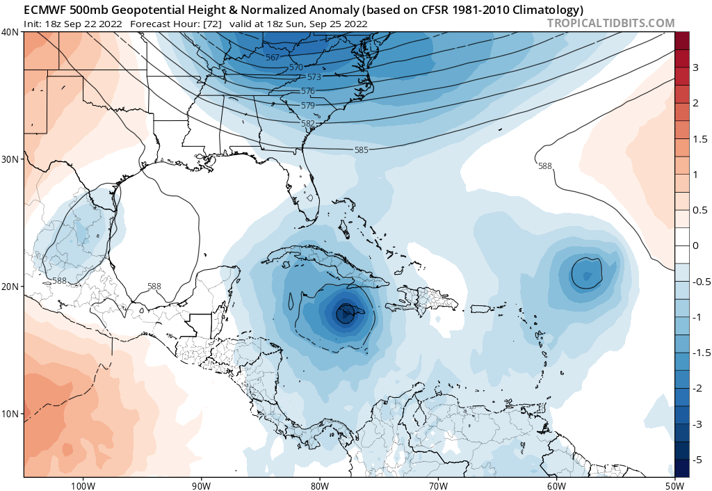
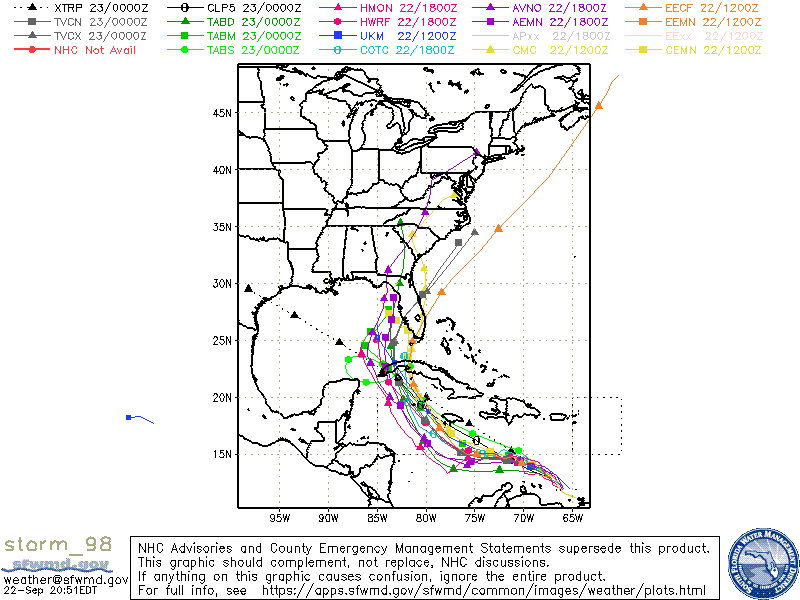
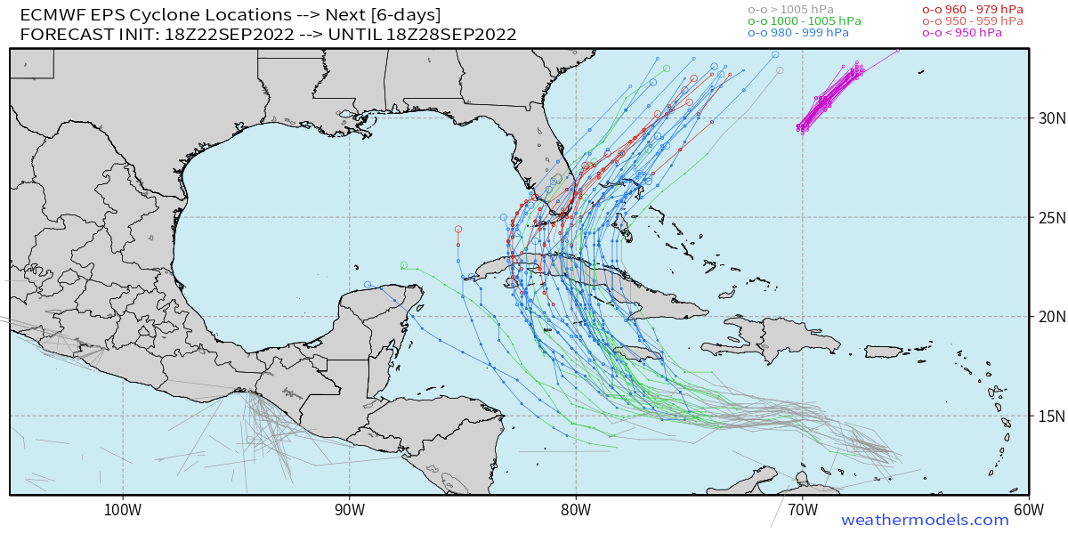
AJC3 wrote:'The center hasn't even formed yet' talk is quickly on its way to becoming null and void from here on out. In fact, this morning's scatterometer data (13Z-14Z) and satellite derived winds showed a pretty well-defined surface-850MB vorticity center that should have gone into the initialization of the 18Z model guidance, and I suspect it will be at least as well-defined in the upcoming 00Z runs. How well the model guidance initializes it is another matter, however we're at the point now where we have a decent LL center fix to work with.

So now it's off to the races.
1 likes   

User avatar
CronkPSU
S2K Supporter
S2K Supporter
Posts: 1900
Joined: Sun Aug 07, 2005 10:44 pm
Location: Avalon Park, FL

Re: ATL: INVEST 98L - Models

#1022 Postby CronkPSU » Thu Sep 22, 2022 7:36 pm


what is going on with the storm once it hits florida, looks like a paintball and scatters all over the place before consolidating again when it hits the Atlantic
3 likes   
Just like Jon Snow..."I know nothing" except what I know, and most of what I know is gathered by the fine people of the NHC

User avatar
SouthFLTropics
Category 5
Category 5
Posts: 4156
Age: 48
Joined: Thu Aug 14, 2003 8:04 am
Location: Port St. Lucie, Florida

Re: ATL: INVEST 98L - Models

#1023 Postby SouthFLTropics » Thu Sep 22, 2022 7:50 pm

Bigger takeaway on the 18z HWRF is the fact that it appears to be turning northeast during the final few frames.


Sent from my iPhone using Tapatalk
0 likes   
Fourth Generation Floridian...With lots of storm knowledge passed down from my elders...

Personal Storm History: David 79, Andrew 92, Erin 95, Floyd 99, Irene 99, Frances 04, Jeanne 04, Wilma 05, Matthew 16, Irma 17

User avatar
gatorcane
S2K Supporter
S2K Supporter
Posts: 23499
Age: 46
Joined: Sun Mar 13, 2005 3:54 pm
Location: Boca Raton, FL

Re: ATL: INVEST 98L - Models

#1024 Postby gatorcane » Thu Sep 22, 2022 7:58 pm

18Z Euro looks a bit stronger and a bit more north at 72 hours. The trough looks stronger too. Wonder if it continues on if it misses Florida to the east entirely? Keep in mind even if it barely misses to the east, there would be minimal impacts with Florida on “dry side” of storm. Bahamas not so much though.

Image
1 likes   

User avatar
SFLcane
S2K Supporter
S2K Supporter
Posts: 9606
Age: 46
Joined: Sat Jun 05, 2010 1:44 pm
Location: Lake Worth Florida

Re: ATL: INVEST 98L - Models

#1025 Postby SFLcane » Thu Sep 22, 2022 8:01 pm

Tcvn now almost to Fort Myers…00z

Image
1 likes   

shah83
Category 1
Category 1
Posts: 269
Joined: Sun Jul 31, 2016 4:55 pm

Re: ATL: INVEST 98L - Models

#1026 Postby shah83 » Thu Sep 22, 2022 8:04 pm

Crazy strong trough on that 18z Euro.
1 likes   

User avatar
ConvergenceZone
Category 5
Category 5
Posts: 4833
Joined: Fri Jul 29, 2005 1:40 am
Location: Northern California

Re: ATL: INVEST 98L - Models

#1027 Postby ConvergenceZone » Thu Sep 22, 2022 8:07 pm

gatorcane wrote:18Z Euro looks a bit stronger and a bit more north at 72 hours. The trough looks stronger too. Wonder if it continues on if it misses Florida to the east entirely? Keep in mind even if it barely misses to the east, there would be minimal impacts with Florida on “dry side” of storm. Bahamas not so much though.

https://i.postimg.cc/3RGSxWB4/ec-fast-z500a-Norm-watl-4.png


Hmm, I wonder if this will be the run where it completely misses Florida?...I guess we will find out.......
Last edited by ConvergenceZone on Thu Sep 22, 2022 8:08 pm, edited 1 time in total.
0 likes   

User avatar
eastcoastFL
Category 5
Category 5
Posts: 3437
Age: 42
Joined: Thu Apr 12, 2007 12:29 pm
Location: Palm City, FL

Re: ATL: INVEST 98L - Models

#1028 Postby eastcoastFL » Thu Sep 22, 2022 8:07 pm

gatorcane wrote:18Z Euro looks a bit stronger and a bit more north at 72 hours. The trough looks stronger too. Wonder if it continues on if it misses Florida to the east entirely? Keep in mind even if it barely misses to the east, there would be minimal impacts with Florida on “dry side” of storm. Bahamas not so much though.

https://i.postimg.cc/3RGSxWB4/ec-fast-z500a-Norm-watl-4.png


Are there any models that are that Far East right now? Would it be weaker since it would spend less time over water and less time near the warmer spots around Cuba and Florida?
0 likes   
Personal Forecast Disclaimer:
The posts in this forum are NOT official forecast and should not be used as such. They are just the opinion of the poster and may or may not be backed by sound meteorological data. They are NOT endorsed by any professional institution or storm2k.org. For official information, please refer to the NHC and NWS products.

SconnieCane
Category 4
Category 4
Posts: 913
Joined: Thu Aug 02, 2018 5:29 pm
Location: Madison, WI

Re: RE: Re: ATL: INVEST 98L - Models

#1029 Postby SconnieCane » Thu Sep 22, 2022 8:08 pm

CronkPSU wrote:


what is going on with the storm once it hits florida, looks like a paintball and scatters all over the place before consolidating again when it hits the Atlantic
That's an ensemble suite, all those low pressure centers are different members' tracks.

Sent from my Pixel 4a using Tapatalk
1 likes   

User avatar
gatorcane
S2K Supporter
S2K Supporter
Posts: 23499
Age: 46
Joined: Sun Mar 13, 2005 3:54 pm
Location: Boca Raton, FL

Re: ATL: INVEST 98L - Models

#1030 Postby gatorcane » Thu Sep 22, 2022 8:09 pm

eastcoastFL wrote:
gatorcane wrote:18Z Euro looks a bit stronger and a bit more north at 72 hours. The trough looks stronger too. Wonder if it continues on if it misses Florida to the east entirely? Keep in mind even if it barely misses to the east, there would be minimal impacts with Florida on “dry side” of storm. Bahamas not so much though.

https://i.postimg.cc/3RGSxWB4/ec-fast-z500a-Norm-watl-4.png


Are there any models that are that Far East right now? Would it be weaker since it would spend less time over water and less time near the warmer spots around Cuba and Florida?


Yes but only the lowly NAVGEM. It shows a weaker storm just missing Florida to the east. Usually you use the NAVGEM to figure out where the storm is not going. :lol: but oddly enough the Euro has been trending toward the NAVGEM.

Image
4 likes   

User avatar
eastcoastFL
Category 5
Category 5
Posts: 3437
Age: 42
Joined: Thu Apr 12, 2007 12:29 pm
Location: Palm City, FL

Re: ATL: INVEST 98L - Models

#1031 Postby eastcoastFL » Thu Sep 22, 2022 8:15 pm

gatorcane wrote:
eastcoastFL wrote:
gatorcane wrote:18Z Euro looks a bit stronger and a bit more north at 72 hours. The trough looks stronger too. Wonder if it continues on if it misses Florida to the east entirely? Keep in mind even if it barely misses to the east, there would be minimal impacts with Florida on “dry side” of storm. Bahamas not so much though.

https://i.postimg.cc/3RGSxWB4/ec-fast-z500a-Norm-watl-4.png


Are there any models that are that Far East right now? Would it be weaker since it would spend less time over water and less time near the warmer spots around Cuba and Florida?


Yes but only the lowly NAVGEM. It shows a weaker storm just missing Florida to the east. Usually you use the NAVGEM to figure out where the storm is not going. :lol: but oddly enough the Euro has been trending toward the NAVGEM.

https://i.postimg.cc/4dGtpdGh/nvg10-sfc10m-120-go-mex.gif


Interesting, a stronger trough in this run looks like a player now. I wonder if that will continue in future runs. Would sure be nice for this to miss the peninsula.
Last edited by eastcoastFL on Thu Sep 22, 2022 8:17 pm, edited 1 time in total.
0 likes   
Personal Forecast Disclaimer:
The posts in this forum are NOT official forecast and should not be used as such. They are just the opinion of the poster and may or may not be backed by sound meteorological data. They are NOT endorsed by any professional institution or storm2k.org. For official information, please refer to the NHC and NWS products.

AutoPenalti
Category 5
Category 5
Posts: 3949
Age: 27
Joined: Mon Aug 17, 2015 4:16 pm
Location: Ft. Lauderdale, Florida

Re: ATL: INVEST 98L - Models

#1032 Postby AutoPenalti » Thu Sep 22, 2022 8:16 pm

Euro 18z a bit east again.
0 likes   
The posts in this forum are NOT official forecasts and should not be used as such. They are just the opinion of the poster and may or may not be backed by sound meteorological data. They are NOT endorsed by any professional institution or STORM2K. For official information, please refer to products from the NHC and NWS.


Model Runs Cheat Sheet:
GFS (5:30 AM/PM, 11:30 AM/PM)
HWRF, GFDL, UKMET, NAVGEM (6:30-8:00 AM/PM, 12:30-2:00 AM/PM)
ECMWF (1:45 AM/PM)

TCVN
is a weighted averaged

LarryWx
Category 5
Category 5
Posts: 5699
Joined: Sun Sep 07, 2003 2:04 pm
Location: GA

Re: ATL: INVEST 98L - Models

#1033 Postby LarryWx » Thu Sep 22, 2022 8:19 pm

18Z EPS mean significantly SE of the 12Z EPS mean with the mean track now just off the SE tip of FL vs over S FL on the 12Z! Practically every track of the 51 18Z members is SE of Ft Myers! There are more tracks SE of FL than in S FL.
Last edited by LarryWx on Thu Sep 22, 2022 8:20 pm, edited 2 times in total.
0 likes   
Personal Forecast Disclaimer:
The posts in this forum are NOT official forecasts and should not be used as such. They are just the opinion of the poster and may or may not be backed by sound meteorological data. They are NOT endorsed by any professional institution or storm2k.org. For official information, please refer to the NHC and NWS products.

User avatar
gatorcane
S2K Supporter
S2K Supporter
Posts: 23499
Age: 46
Joined: Sun Mar 13, 2005 3:54 pm
Location: Boca Raton, FL

Re: ATL: INVEST 98L - Models

#1034 Postby gatorcane » Thu Sep 22, 2022 8:19 pm

AutoPenalti wrote:Euro 18z a bit east again.


And weaker. It would have to cross over the high Terrain of Cuba to reach Florida and also probably would miss Florida to the east.

Saved loop:

Image
0 likes   

User avatar
gatorcane
S2K Supporter
S2K Supporter
Posts: 23499
Age: 46
Joined: Sun Mar 13, 2005 3:54 pm
Location: Boca Raton, FL

Re: ATL: INVEST 98L - Models

#1035 Postby gatorcane » Thu Sep 22, 2022 8:23 pm

LarryWx wrote:18Z EPS mean significantly SE of the 12Z EPS mean with the mean track now just off the SE tip of FL vs over S FL on the 12Z! Practically every track of the 51 18Z members is SE of Ft Myers! There are more tracks SE of FL than in S FL.


Wow this is some trough! Is it November?!? To think it could track east of Florida is not what I expected. We will know with tonight’s runs if it is a trend or just windshield wiping.
0 likes   

User avatar
Iceresistance
Category 5
Category 5
Posts: 8910
Age: 20
Joined: Sat Oct 10, 2020 9:45 am
Location: Tecumseh, OK/Norman, OK

Re: ATL: INVEST 98L - Models

#1036 Postby Iceresistance » Thu Sep 22, 2022 8:25 pm

gatorcane wrote:
LarryWx wrote:18Z EPS mean significantly SE of the 12Z EPS mean with the mean track now just off the SE tip of FL vs over S FL on the 12Z! Practically every track of the 51 18Z members is SE of Ft Myers! There are more tracks SE of FL than in S FL.


Wow this is some trough! Is it November?!? To think it could track east of Florida is not going with climo that is for sure.


It seems like Winter wants to start early.

Does it seem like that the models either underestimate or overestimate the trough more often than not?
0 likes   
Bill 2015 & Beta 2020

Winter 2020-2021 :cold:

All observations are in Tecumseh, OK unless otherwise noted.

Winter posts are focused mainly for Oklahoma & Texas.

Take any of my forecasts with a grain of salt, refer to the NWS, SPC, and NHC for official information

Never say Never with weather! Because ANYTHING is possible!

Pelicane
Tropical Depression
Tropical Depression
Posts: 51
Joined: Tue Sep 13, 2022 1:52 pm
Location: Lafayette, Louisiana

Re: ATL: INVEST 98L - Models

#1037 Postby Pelicane » Thu Sep 22, 2022 8:26 pm

18z Euro Ensembles
Image
1 likes   

AxaltaRacing24
Category 5
Category 5
Posts: 1709
Age: 23
Joined: Wed Jul 27, 2016 11:14 am
Location: Jupiter, FL

Re: ATL: INVEST 98L - Models

#1038 Postby AxaltaRacing24 » Thu Sep 22, 2022 8:27 pm

gatorcane wrote:
LarryWx wrote:18Z EPS mean significantly SE of the 12Z EPS mean with the mean track now just off the SE tip of FL vs over S FL on the 12Z! Practically every track of the 51 18Z members is SE of Ft Myers! There are more tracks SE of FL than in S FL.


Wow this is some trough! Is it November?!? To think it could track east of Florida is not what I expected. We will know with tonight’s runs if it is a trend or just windshield wiping.

My guess is that it is 65% trend and 35% windshield wiping. Irma's tracks did this too
0 likes   

caneseddy
Category 5
Category 5
Posts: 1138
Joined: Fri Sep 03, 2004 9:31 pm
Location: Plantation, FL

Re: ATL: INVEST 98L - Models

#1039 Postby caneseddy » Thu Sep 22, 2022 8:30 pm


Interesting that the stronger members hit south Florida and weaker ones stay east
0 likes   

User avatar
toad strangler
S2K Supporter
S2K Supporter
Posts: 4162
Joined: Sun Jul 28, 2013 3:09 pm
Location: Earth
Contact:

Re: ATL: INVEST 98L - Models

#1040 Postby toad strangler » Thu Sep 22, 2022 8:30 pm

gatorcane wrote:
AutoPenalti wrote:Euro 18z a bit east again.


And weaker. It would have to cross over the high Terrain of Cuba to reach Florida and also probably would miss Florida to the east.

Saved loop:

https://i.postimg.cc/y8F0xc4z/ecmwf-z850-vort-watl-fh0-90.gif


Quite a bit different than buying into the GFS west of FL solutions just 24 hours ago right gator? Perhaps you are learning that loyalty to a climo calendar isn’t bullet proof! We never stop learning!
Last edited by toad strangler on Thu Sep 22, 2022 8:31 pm, edited 2 times in total.
1 likes   


Return to “2022”

Who is online

Users browsing this forum: No registered users and 19 guests