ATL: IAN - Post-Tropical - Discussion
Moderator: S2k Moderators
-
CrazyC83
- Professional-Met

- Posts: 33393
- Joined: Tue Mar 07, 2006 11:57 pm
- Location: Deep South, for the first time!
Re: ATL: INVEST 98L - Discussion
Would the ABC Islands need a Tropical Storm Warning now? If so, they should pull the trigger on PTC 9 or TD 9.
0 likes
-
SFLcane

- S2K Supporter

- Posts: 9606
- Age: 46
- Joined: Sat Jun 05, 2010 1:44 pm
- Location: Lake Worth Florida
Re: ATL: INVEST 98L - Discussion
2 likes
-
REDHurricane

- Tropical Storm

- Posts: 206
- Age: 26
- Joined: Sun Jul 03, 2022 2:36 pm
- Location: Northeast Pacific Ocean
Re: ATL: INVEST 98L - Discussion
CrazyC83 wrote:Would the ABC Islands need a Tropical Storm Warning now? If so, they should pull the trigger on PTC 9 or TD 9.
Yep looks like it, just based on the previous PTCs this season I'm thinking they will definitely do it within the next few hours
2 likes
-
Keldeo1997
- Category 2

- Posts: 514
- Joined: Fri Oct 11, 2019 11:35 pm

Re: ATL: INVEST 98L - Discussion
Keldeo1997 wrote:I know some people on here like their Hebert box's
New one on me, and I'm iffy on whether it's "a thing", but now I want to see something similar for Louisiana.
1 likes
Baton Rouge area cyclone dilettante, PSWAGGER* tropical weather & hydrology model developer
(* Pseudo-Scientific Wild-A** Guesses Generally Expressed Ridiculously)
The GFDL would've had all this figured out by now.
(* Pseudo-Scientific Wild-A** Guesses Generally Expressed Ridiculously)
The GFDL would've had all this figured out by now.
-
eastcoastFL

- Category 5

- Posts: 3437
- Age: 42
- Joined: Thu Apr 12, 2007 12:29 pm
- Location: Palm City, FL
Re: ATL: INVEST 98L - Discussion
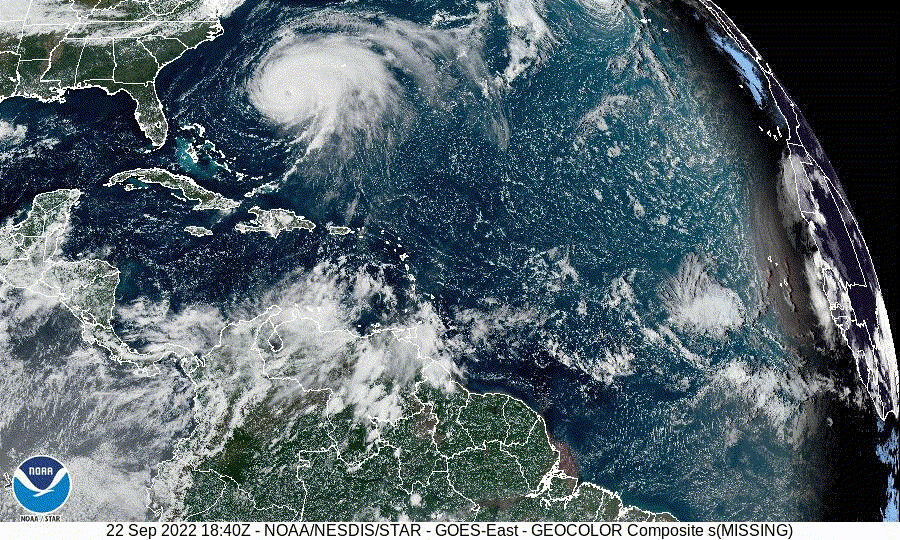
Anyone know when the next ASCAT pass is? The last one looked pretty close to being closed off.
0 likes
Personal Forecast Disclaimer:
The posts in this forum are NOT official forecast and should not be used as such. They are just the opinion of the poster and may or may not be backed by sound meteorological data. They are NOT endorsed by any professional institution or storm2k.org. For official information, please refer to the NHC and NWS products.
The posts in this forum are NOT official forecast and should not be used as such. They are just the opinion of the poster and may or may not be backed by sound meteorological data. They are NOT endorsed by any professional institution or storm2k.org. For official information, please refer to the NHC and NWS products.
-
skyline385

- Category 5
- Posts: 2444
- Age: 33
- Joined: Wed Aug 26, 2020 11:15 pm
- Location: Palm Beach County FL
Re: ATL: INVEST 98L - Discussion
Should have atleast been a TD especially with the the Radar loop and the ASCAT pass from earlier

Sent from my iPhone using Tapatalk
Sent from my iPhone using Tapatalk
5 likes
-
Aric Dunn
- Category 5
- Posts: 21228
- Age: 41
- Joined: Sun Sep 19, 2004 9:58 pm
- Location: Ready for the Chase.
- Contact:
Re: ATL: INVEST 98L - Discussion
All I have to say about this ( and well many other systems recently).....
" Can’t help but think NHC forecasters are delighted they’re not issuing PTC advisories on 98L tonight. Because that’s a 5-day forecast you’re really not ready to make."
darn those models.. just so indecisive....
" Can’t help but think NHC forecasters are delighted they’re not issuing PTC advisories on 98L tonight. Because that’s a 5-day forecast you’re really not ready to make."
darn those models.. just so indecisive....
12 likes
Note: If I make a post that is brief. Please refer back to previous posts for the analysis or reasoning. I do not re-write/qoute what my initial post said each time.
If there is nothing before... then just ask
Space & Atmospheric Physicist, Embry-Riddle Aeronautical University,
I believe the sky is falling...
If there is nothing before... then just ask
Space & Atmospheric Physicist, Embry-Riddle Aeronautical University,
I believe the sky is falling...

Re: ATL: INVEST 98L - Discussion
I’m in agreement that this is (or at least is imminently becoming) a TD. Thought we might see the NHC pull the trigger at 11 PM, but I guess we’ll have to wait a few hours. Best-track may end up reflecting this later on when revisions are made.
4 likes

Re: ATL: INVEST 98L - Discussion
I didnt think it would be classified until Saturday but now am fairly certain this will at least be a TD tomorrow (Friday). With what appears to be a closed low, doubt PTC advisories will be needed. If this trend continues we might have a TD at 5am.
5 likes
-
TheHurricaneGod
- Tropical Storm
- Posts: 146
- Age: 21
- Joined: Thu Apr 16, 2020 6:19 pm
- Location: Fort Lauderdale
Re: ATL: INVEST 98L - Discussion
Aric Dunn wrote:All I have to say about this ( and well many other systems recently).....
" Can’t help but think NHC forecasters are delighted they’re not issuing PTC advisories on 98L tonight. Because that’s a 5-day forecast you’re really not ready to make."
darn those models.. just so indecisive....
Hall & Oates - Out of Touch
1 likes
-
Poonwalker
- Tropical Storm
- Posts: 146
- Joined: Tue Sep 20, 2022 11:12 am
Re: ATL: INVEST 98L - Discussion
I think we will be skipping the TD status after the recon mission enters this. Fiona is picking up speed and exiting, shear should lessen, and that convection popping will only improve with Dmax coming. I reckon we will have a TS early morning.
2 likes
-
Aric Dunn
- Category 5
- Posts: 21228
- Age: 41
- Joined: Sun Sep 19, 2004 9:58 pm
- Location: Ready for the Chase.
- Contact:
Re: ATL: INVEST 98L - Discussion
Jr0d wrote:I didnt think it would be classified until Saturday but now am fairly certain this will at least be a TD tomorrow (Friday). With what appears to be a closed low, doubt PTC advisories will be needed. If this trend continues we might have a TD at 5am.
I bet 57 will still say sunday/monday just because.
9 likes
Note: If I make a post that is brief. Please refer back to previous posts for the analysis or reasoning. I do not re-write/qoute what my initial post said each time.
If there is nothing before... then just ask
Space & Atmospheric Physicist, Embry-Riddle Aeronautical University,
I believe the sky is falling...
If there is nothing before... then just ask
Space & Atmospheric Physicist, Embry-Riddle Aeronautical University,
I believe the sky is falling...
-
stormhunter7

- Category 2
- Posts: 733
- Joined: Mon May 26, 2008 3:13 pm
- Location: Panama City Beach, Florida
- Contact:
Re: ATL: INVEST 98L - Discussion
I think all we are missing is a ground obs report or ship report? Radar velocity data might make this a TD as it passes by the Island. If the shear keeps up for next two days... This may be what keeps the system a little further south of potential track. Deep convection fires on SW side... Pulls the surface CoC to the SW. If the convection is this tall/cold now. Hang on to your hat, cus it's gonna be really interesting come Sunday/Monday... Or when it reaches the western Caribbean, IMO.
2 likes
The following post is NOT an official forecast and should not be used as such. It is just the opinion of the poster and may or may not be backed by sound meteorological data. It is NOT endorsed by any professional institution including storm2k.org For Official Information please refer to the NHC and NWS products. http://www.nhc.noaa.gov
-
Craters
- Category 1

- Posts: 349
- Joined: Sat Aug 24, 2013 2:34 pm
- Location: Alvin, TX (south of Houston)
Re: ATL: INVEST 98L - Discussion
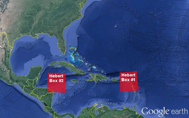
LARanger wrote:Keldeo1997 wrote:I know some people on here like their Hebert box's
New one on me, and I'm iffy on whether it's "a thing", but now I want to see something similar for Louisiana.
Ask and you shall receive, LARanger:

(I think the US boundaries are a little bit off...)
20 likes
Nothing that I post here should ever be treated as a forecast or anything resembling one. Please check with your local NWS office or the NHC for forecasts, watches, and warnings.
-
skyline385
- Category 5
- Posts: 2444
- Age: 33
- Joined: Wed Aug 26, 2020 11:15 pm
- Location: Palm Beach County FL
Re: ATL: INVEST 98L - Discussion
Aric Dunn wrote:All I have to say about this ( and well many other systems recently).....
" Can’t help but think NHC forecasters are delighted they’re not issuing PTC advisories on 98L tonight. Because that’s a 5-day forecast you’re really not ready to make."
darn those models.. just so indecisive....
And just as you said that, 0Z ICON decided to be west of previous runs
0 likes

Re: ATL: INVEST 98L - Discussion
skyline385 wrote:Aric Dunn wrote:All I have to say about this ( and well many other systems recently).....
" Can’t help but think NHC forecasters are delighted they’re not issuing PTC advisories on 98L tonight. Because that’s a 5-day forecast you’re really not ready to make."
darn those models.. just so indecisive....
And just as you said that, 0Z ICON decided to be west of previous runs
And significantly stronger too (966 mb at landfall). That's probably a result of the W track giving it more time to intensify.
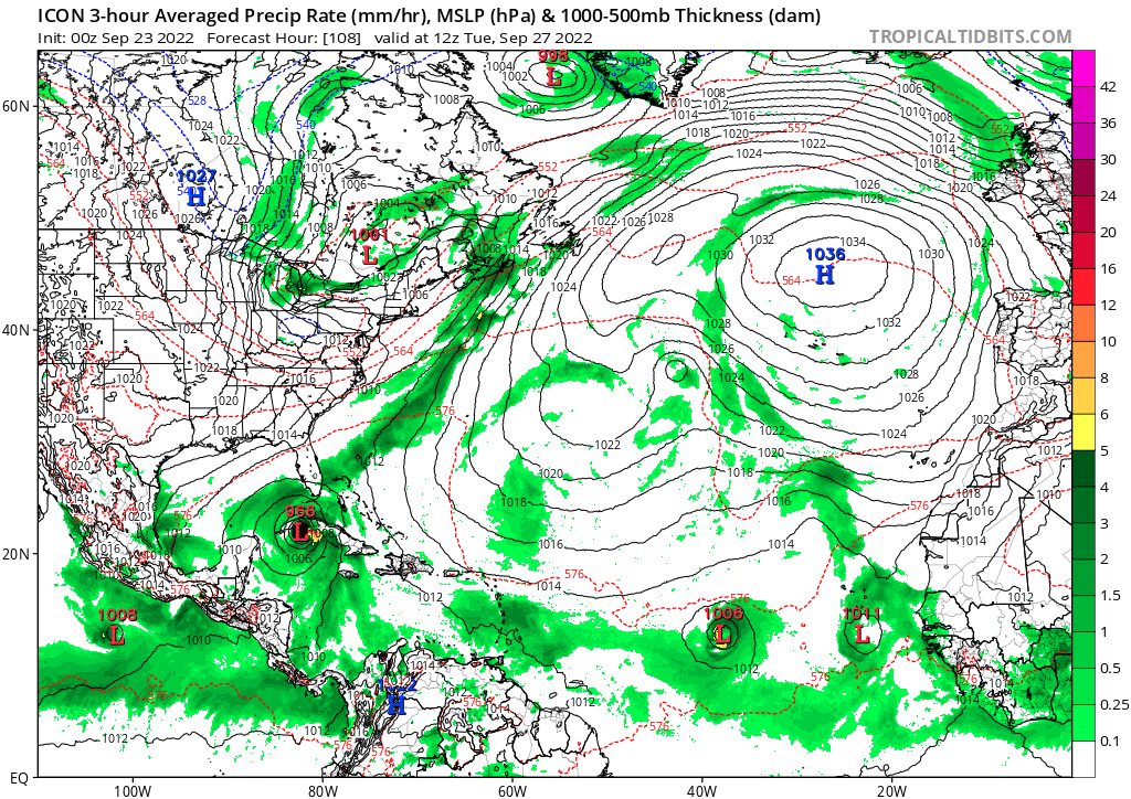
Edit: Can a mod move this to the models thread? I didn't realize this is in the discussion thread.
Last edited by Teban54 on Thu Sep 22, 2022 10:36 pm, edited 1 time in total.
1 likes
-
Aric Dunn
- Category 5
- Posts: 21228
- Age: 41
- Joined: Sun Sep 19, 2004 9:58 pm
- Location: Ready for the Chase.
- Contact:
Re: ATL: INVEST 98L - Discussion
skyline385 wrote:Aric Dunn wrote:All I have to say about this ( and well many other systems recently).....
" Can’t help but think NHC forecasters are delighted they’re not issuing PTC advisories on 98L tonight. Because that’s a 5-day forecast you’re really not ready to make."
darn those models.. just so indecisive....
And just as you said that, 0Z ICON decided to be west of previous runs
well I mean.. not that ICON is particularly reliable amongst the rest.. but earlier I said not to buy stock in the eastern solutions..
5 likes
Note: If I make a post that is brief. Please refer back to previous posts for the analysis or reasoning. I do not re-write/qoute what my initial post said each time.
If there is nothing before... then just ask
Space & Atmospheric Physicist, Embry-Riddle Aeronautical University,
I believe the sky is falling...
If there is nothing before... then just ask
Space & Atmospheric Physicist, Embry-Riddle Aeronautical University,
I believe the sky is falling...
-
Sciencerocks
- Category 5
- Posts: 7282
- Age: 38
- Joined: Thu Jul 06, 2017 1:51 am
Who is online
Users browsing this forum: No registered users and 22 guests