ATL: IAN - Models
Moderator: S2k Moderators
-
TheHurricaneGod
- Tropical Storm

- Posts: 146
- Age: 21
- Joined: Thu Apr 16, 2020 6:19 pm
- Location: Fort Lauderdale
Re: ATL: INVEST 98L - Models
Going to settle in between the euro and GFS for now. After considering those model biases. good night. see yall tomorrow morning.
0 likes
-
sphelps8681
- Category 2

- Posts: 673
- Joined: Thu Aug 16, 2007 5:37 pm
- Location: Somewhere over the rainbow

-
cheezyWXguy

- Category 5

- Posts: 5554
- Joined: Mon Feb 13, 2006 12:29 am
- Location: Dallas, TX
Re: ATL: INVEST 98L - Models
Keldeo1997 wrote:https://twitter.com/DerekOrtt/status/1573079149815775234
One thing to note is that the GFS might be over doing the shear in the gulf.
Yes and no. It’s probably not overdoing shear from an environmental standpoint, given the setup, but it probably is from a storm-relative standpoint. A more realistic outcome would be for the storm to travel more east with the flow, instead of fighting it.
4 likes
-
eastcoastFL

- Category 5
- Posts: 3437
- Age: 42
- Joined: Thu Apr 12, 2007 12:29 pm
- Location: Palm City, FL
Re: ATL: INVEST 98L - Models
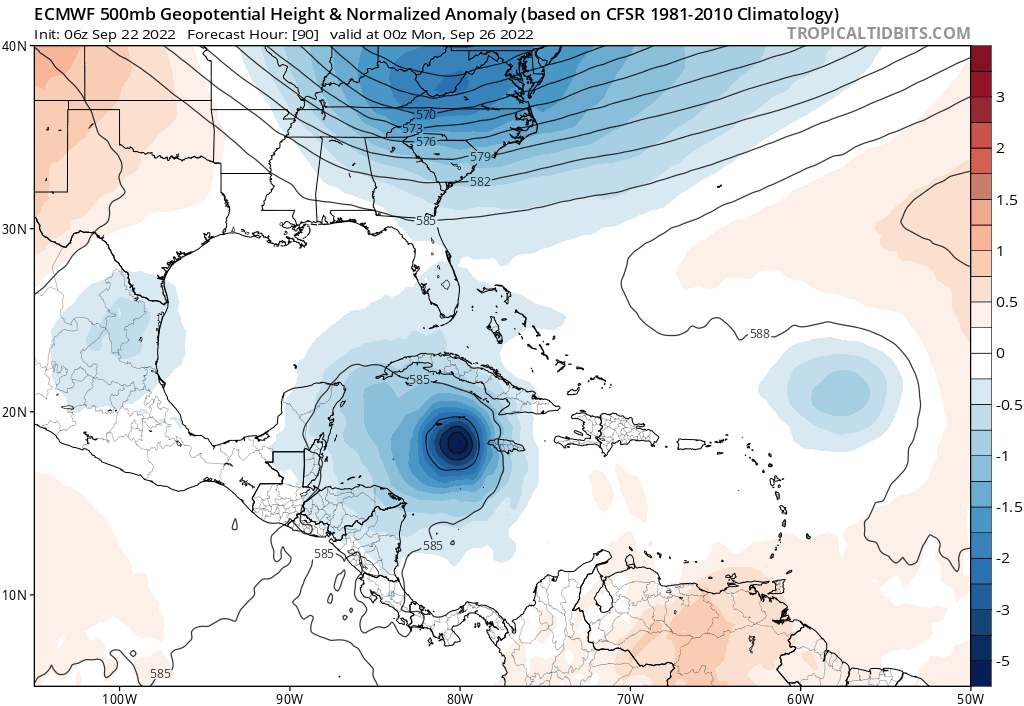
AxaltaRacing24 wrote:eastcoastFL wrote:aspen wrote:What causes the Euro to be weaker but turn north sooner, and the GFS/HWRF to be stronger and further south? It’s such a weird flip-flop of typical model track biases.
I think it’s weaker because it spends more time over mountainous parts of Cuba in this run and misses out on more time over the warmest waters. So it’s kinda beat after it crosses Cuba. That part makes sense. The quicker turn north I’m not so sold on. It will be interesting if the other models predict a trough as strong as the euro has in this run.
At this point I would not be shocked if at least 20% of this is just windshield wiping. Definitely could miss us to the east, but too early to see if it won't swing back west just as easily. I remember the windshield wiping with Irma, as it appeared there was a good chance it would miss us to the east.
I think you’re right and we’re in for a weekend full of model shifts back and fourth. Irma had me drive to my in laws west of Orlando only to wake up the next day and drive back to PSL. Fun stuff
5 likes
Personal Forecast Disclaimer:
The posts in this forum are NOT official forecast and should not be used as such. They are just the opinion of the poster and may or may not be backed by sound meteorological data. They are NOT endorsed by any professional institution or storm2k.org. For official information, please refer to the NHC and NWS products.
The posts in this forum are NOT official forecast and should not be used as such. They are just the opinion of the poster and may or may not be backed by sound meteorological data. They are NOT endorsed by any professional institution or storm2k.org. For official information, please refer to the NHC and NWS products.
Re: ATL: INVEST 98L - Models
The 18z euro is already to far N and E with its initialization and the furthest sw members all end up in w Cuba and don’t miss FL. This is important in the trends… and it will almost have to correct back west on upcoming runs. We should have a td very soon so initializations should get much better
3 likes
-
skyline385

- Category 5
- Posts: 2460
- Age: 33
- Joined: Wed Aug 26, 2020 11:15 pm
- Location: Houston TX
Re: ATL: INVEST 98L - Models
0Z ICON decides to go significantly west of previous runs, 18Z was almost missing SFL entirely.
And then it rides up the spine of Florida to 180 hours, literally worst case scenario

And then it rides up the spine of Florida to 180 hours, literally worst case scenario
Last edited by skyline385 on Thu Sep 22, 2022 10:51 pm, edited 2 times in total.
1 likes
-
cheezyWXguy
- Category 5
- Posts: 5554
- Joined: Mon Feb 13, 2006 12:29 am
- Location: Dallas, TX
Re: ATL: INVEST 98L - Models
skyline385 wrote:0Z ICON decides to go significantly west of previous runs, 18Z was almost missing SFL entirely.
And then it rides up the spine of Florida to 180 hours, literally worst case scenario
https://i.imgur.com/YULDT5v.png
Guessing because it shows a much stronger system
1 likes
Re: ATL: INVEST 98L - Models
skyline385 wrote:0Z ICON decides to go significantly west of previous runs, 18Z was almost missing SFL entirely.
https://i.imgur.com/YULDT5v.png
From the SE tip of Florida to Naples..putting South Florida on the dirty side..Wilma part 2
Oof that run of Icon is really bad for the whole state. eyewall rake the entire East Coast of the state up to Orlando
2 likes
-
skyline385
- Category 5
- Posts: 2460
- Age: 33
- Joined: Wed Aug 26, 2020 11:15 pm
- Location: Houston TX
Re: ATL: INVEST 98L - Models
GFS 0Z going to be west again probably, there's the center relocation again

2 likes
Re: ATL: INVEST 98L - Models
caneseddy wrote:skyline385 wrote:0Z ICON decides to go significantly west of previous runs, 18Z was almost missing SFL entirely.
https://i.imgur.com/YULDT5v.png
From the SE tip of Florida to Naples..putting South Florida on the dirty side..Wilma part 2
Oof that run of Icon is really bad for the whole state. eyewall rake the entire East Coast of the state up to Orlando
As depicted, likely worse than Wilma, because at least she was booking along at 20mph. This one is a lingerer...
1 likes

-
Keldeo1997
- Category 2
- Posts: 514
- Joined: Fri Oct 11, 2019 11:35 pm

Re: ATL: INVEST 98L - Models
0Z GFS has a strong hurricane hitting W Cuba. Guessing this will be a big bend hit again.
0 likes
-
skyline385
- Category 5
- Posts: 2460
- Age: 33
- Joined: Wed Aug 26, 2020 11:15 pm
- Location: Houston TX
Re: ATL: INVEST 98L - Models
Keldeo1997 wrote:https://cdn.discordapp.com/attachments/1022688973581201488/1022719056199032852/unknown.png
GFS much stronger
951mb landfall on Cuba
0 likes

Re: ATL: INVEST 98L - Models
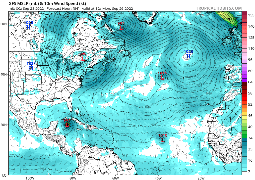
GFS running showing a 957 system moving N through Western Cuba. Florida may be in big big trouble!
https://www.tropicaltidbits.com/analysis/models/?model=gfs®ion=us&pkg=mslp_pcpn_frzn&runtime=2022092300&fh=96
https://www.tropicaltidbits.com/analysis/models/?model=gfs®ion=us&pkg=mslp_pcpn_frzn&runtime=2022092300&fh=96
Last edited by sponger on Thu Sep 22, 2022 11:07 pm, edited 1 time in total.
0 likes
The following post is NOT an official forecast and should not be used as such. It is just the opinion of the poster and may or may not be backed by sound meteorological data. It is NOT endorsed by any professional institution including storm2k.org For Official Information please refer to the NHC and NWS products.
-
skyline385
- Category 5
- Posts: 2460
- Age: 33
- Joined: Wed Aug 26, 2020 11:15 pm
- Location: Houston TX
Re: ATL: INVEST 98L - Models
sponger wrote:GFS running showing a 957 system moving N through Western Cuba. Florida may be in big big trouble!
https://www.tropicaltidbits.com/analysis/models/?model=gfs®ion=us&pkg=mslp_pcpn_frzn&runtime=2022092300&fh=96
Just completed the turn, headed towards Ft. Meyers probably this run

Last edited by skyline385 on Thu Sep 22, 2022 11:09 pm, edited 2 times in total.
0 likes
-
HurricaneBelle

- S2K Supporter

- Posts: 975
- Joined: Sun Aug 27, 2006 6:12 pm
- Location: Clearwater, FL

-
HurricaneBelle
- S2K Supporter
- Posts: 975
- Joined: Sun Aug 27, 2006 6:12 pm
- Location: Clearwater, FL
Re: ATL: INVEST 98L - Models
Well this is an east shift for the GFS, since it's headed into west central Florida instead of the panhandle
Last edited by HurricaneBelle on Thu Sep 22, 2022 11:09 pm, edited 1 time in total.
0 likes
-
CrazyC83
- Professional-Met

- Posts: 33393
- Joined: Tue Mar 07, 2006 11:57 pm
- Location: Deep South, for the first time!
Re: ATL: INVEST 98L - Models
That's less than 5 days away too. That's going to have to show up on the first forecast if they call this PTC 9 or TD 9 tomorrow morning (say, at the 5 am advisory).
4 likes
Who is online
Users browsing this forum: No registered users and 41 guests