
ATL: IAN - Models
Moderator: S2k Moderators
-
AutoPenalti
- Category 5

- Posts: 4091
- Age: 29
- Joined: Mon Aug 17, 2015 4:16 pm
- Location: Ft. Lauderdale, Florida
Re: ATL: NINE - Models
Quite the change.
3 likes
The posts in this forum are NOT official forecasts and should not be used as such. They are just the opinion of the poster and may or may not be backed by sound meteorological data. They are NOT endorsed by any professional institution or STORM2K. For official information, please refer to products from the NHC and NWS.
Model Runs Cheat Sheet:
GFS (5:30 AM/PM, 11:30 AM/PM)
HWRF, GFDL, UKMET, NAVGEM (6:30-8:00 AM/PM, 12:30-2:00 AM/PM)
ECMWF (1:45 AM/PM)
TCVN is a weighted averaged
-
TheHurricaneGod
- Tropical Storm

- Posts: 165
- Age: 23
- Joined: Thu Apr 16, 2020 6:19 pm
- Location: Fort Lauderdale
Re: ATL: NINE - Models
SFLcane wrote:AutoPenalti wrote:So why is the GFS ramming through the trough?
https://i.imgur.com/dom8FUP.png
Thats just dumb!
It should have started turning NE around hour 90 if you look at the z500 vort map.
1 likes
Re: ATL: NINE - Models
caneman wrote:SFLcane wrote:I have my money on the most consistent ECMWF and its mean which are still across South Florida. GFS is likely as stated many times to far west still and its been all over the place.
https://i.postimg.cc/bNLPgTHY/tcvn.jpg
Tampa or Ft. Myers coming from South to North is only a 30-50 mile adjustment east or west. I'm not putting my money on either wIth such a small margin of error. Both need to be prepared. CHARLEY proved a small jog can be massive on impacts.
Yeah, that "Charley jog" certainly took a lot of people by surprise. I saw that slight "right turn jog" Charley took and knew it was game on.
But it was the "Andrew 1-degree" that made a believer outta me! We were "1 degree" difference from Ft. Lauderdale to Homestead when Andrew blew through. We went through 12 hours of no electricity, but barely even a limb off one tree.....compared to.....well, compared to Homestead.
One degree, 60 miles can be a world of difference.
5 likes
Cleo - 1964, Betsy - 1965, David - 1979, Andrew - 1992, Charlie (Francis, Ivan, Jeanne) - 2004, Irma - 2017, Ian - 2022, Milton - 2024

Re: ATL: NINE - Models
The GFS is real stubborn... still insisting on that stall and well west of the other models.
3 likes
Igor 2010, Sandy 2012, Fay 2014, Gonzalo 2014, Joaquin 2015, Nicole 2016, Humberto 2019, Imelda 2025
I am only a tropical weather enthusiast. My predictions are not official and may or may not be backed by sound meteorological data. For official information, please refer to the NHC and NWS products.
I am only a tropical weather enthusiast. My predictions are not official and may or may not be backed by sound meteorological data. For official information, please refer to the NHC and NWS products.
Re: ATL: NINE - Models
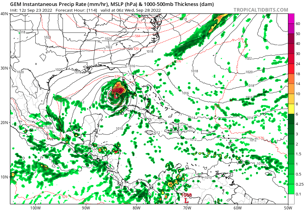
Strange run of the GFS
Appears to stall well west of Tampa and begins to weaken a little.
Appears to stall well west of Tampa and begins to weaken a little.
1 likes
-
toad strangler

- S2K Supporter

- Posts: 4546
- Joined: Sun Jul 28, 2013 3:09 pm
- Location: Earth
- Contact:
Re: ATL: NINE - Models
Kazmit wrote:The GFS is real stubborn... still insisting on that stall and well west of the other models.
I've been saying for days that this stall just isn't on the table. I don't buy it for a second. FUBAR
2 likes
My Weather Station
https://www.wunderground.com/dashboard/pws/KFLPORTS603
https://www.wunderground.com/dashboard/pws/KFLPORTS603
-
skyline385

- Category 5
- Posts: 2728
- Age: 35
- Joined: Wed Aug 26, 2020 11:15 pm
- Location: Houston TX
Re: ATL: NINE - Models
AutoPenalti wrote:So why is the GFS ramming through the trough?

Because of the ridge to the east of it (look at the 588 dm height)

Sent from my iPhone using Tapatalk
3 likes
-
gatorcane

- S2K Supporter
- Posts: 23708
- Age: 48
- Joined: Sun Mar 13, 2005 3:54 pm
- Location: Boca Raton, FL
Re: ATL: NINE - Models
ncapps wrote:Strange run of the GFS
Appears to stall well west of Tampa and begins to weaken a little.
Tampa shield in full-effect. Last time that areas saw a major was 1921.
4 likes
-
tolakram
- Admin

- Posts: 20186
- Age: 62
- Joined: Sun Aug 27, 2006 8:23 pm
- Location: Florence, KY (name is Mark)
Re: ATL: NINE - Models
Slow north and weakening. I think the GFS believes it gets stuck on the left side of that ridge.

4 likes
M a r k
- - - - -
Join us in chat: Storm2K Chatroom Invite. Android and IOS apps also available.
The posts in this forum are NOT official forecasts and should not be used as such. Posts are NOT endorsed by any professional institution or STORM2K.org. For official information and forecasts, please refer to NHC and NWS products.
Re: ATL: NINE - Models
Still landfalls in the Cape Coral/Fort Myers area which is not that different from the last run.
1 likes
-
jlauderdal
- S2K Supporter
- Posts: 7240
- Joined: Wed May 19, 2004 5:46 am
- Location: NE Fort Lauderdale
- Contact:
Re: RE: Re: ATL: NINE - Models
Because the gfs does that sometimes, models are far from perfect. NHC track looks real good, maybe a little too far W but they have time too adjust.AutoPenalti wrote:So why is the GFS ramming through the trough?
1 likes
-
skyline385
- Category 5
- Posts: 2728
- Age: 35
- Joined: Wed Aug 26, 2020 11:15 pm
- Location: Houston TX
Re: ATL: NINE - Models
ICON has the same ridge too just more eastwards so it stalls offshore near WPB

Sent from my iPhone using Tapatalk
Sent from my iPhone using Tapatalk
1 likes
Re: ATL: NINE - Models
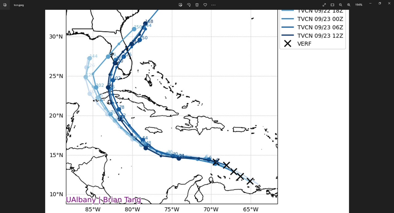
12Z UKMET a big shift back to the SW with it stalling at the 85W longitude 200 miles west of Naples:
TROPICAL DEPRESSION 09L ANALYSED POSITION : 14.4N 69.4W
ATCF IDENTIFIER : AL092022
LEAD CENTRAL MAXIMUM WIND
VERIFYING TIME TIME POSITION PRESSURE (MB) SPEED (KNOTS)
-------------- ---- -------- ------------- -------------
1200UTC 23.09.2022 0 14.4N 69.4W 1009 24
0000UTC 24.09.2022 12 15.1N 71.6W 1008 26
1200UTC 24.09.2022 24 15.0N 74.1W 1007 29
0000UTC 25.09.2022 36 15.0N 76.2W 1005 28
1200UTC 25.09.2022 48 15.8N 78.5W 1004 31
0000UTC 26.09.2022 60 17.3N 80.4W 1002 33
1200UTC 26.09.2022 72 19.1N 82.1W 1000 34
0000UTC 27.09.2022 84 21.2N 82.8W 998 40
1200UTC 27.09.2022 96 23.4N 84.1W 997 38
0000UTC 28.09.2022 108 24.5N 85.0W 995 42
1200UTC 28.09.2022 120 25.2N 85.1W 996 44
0000UTC 29.09.2022 132 25.9N 84.9W 996 48
1200UTC 29.09.2022 144 26.1N 84.8W 996 50
Last edited by LarryWx on Fri Sep 23, 2022 11:21 am, edited 1 time in total.
1 likes
Personal Forecast Disclaimer:
The posts in this forum are NOT official forecasts and should not be used as such. They are just the opinion of the poster and may or may not be backed by sound meteorological data. They are NOT endorsed by any professional institution or storm2k.org. For official information, please refer to the NHC and NWS products.
The posts in this forum are NOT official forecasts and should not be used as such. They are just the opinion of the poster and may or may not be backed by sound meteorological data. They are NOT endorsed by any professional institution or storm2k.org. For official information, please refer to the NHC and NWS products.
-
RevanTheJedi96
- Tropical Storm
- Posts: 106
- Joined: Wed Sep 01, 2021 10:40 am
Re: ATL: NINE - Models
Very strange run. The GFS has been so good recently that it makes me believe it's seeing something the other models aren't.
Guessing that TD 09 riding up the East Cosst is off the table now?
Guessing that TD 09 riding up the East Cosst is off the table now?
Last edited by RevanTheJedi96 on Fri Sep 23, 2022 11:20 am, edited 1 time in total.
1 likes
-
SFLcane

- S2K Supporter
- Posts: 10281
- Age: 48
- Joined: Sat Jun 05, 2010 1:44 pm
- Location: Lake Worth Florida
Re: ATL: NINE - Models
caneseddy wrote:
Still landfalls in the Cape Coral/Fort Myers area which is not that different from the last run.
Old run my bad. Yes a shift into the gulf. Euro next.
South florida ends with a few showers
1 likes
-
SouthFLTropics

- Category 5
- Posts: 4258
- Age: 50
- Joined: Thu Aug 14, 2003 8:04 am
- Location: Port St. Lucie, Florida
Re: ATL: NINE - Models
CMC I’m seeing is way west of 00z…. Looks like it’s making a loop in the GOM.
1 likes
Fourth Generation Florida Native
Personal Storm History: David 79, Andrew 92, Erin 95, Floyd 99, Irene 99, Frances 04, Jeanne 04, Wilma 05, Matthew 16, Irma 17, Ian 22, Nicole 22, Milton 24
Personal Storm History: David 79, Andrew 92, Erin 95, Floyd 99, Irene 99, Frances 04, Jeanne 04, Wilma 05, Matthew 16, Irma 17, Ian 22, Nicole 22, Milton 24
-
tolakram
- Admin
- Posts: 20186
- Age: 62
- Joined: Sun Aug 27, 2006 8:23 pm
- Location: Florence, KY (name is Mark)
Re: ATL: NINE - Models

1 likes
M a r k
- - - - -
Join us in chat: Storm2K Chatroom Invite. Android and IOS apps also available.
The posts in this forum are NOT official forecasts and should not be used as such. Posts are NOT endorsed by any professional institution or STORM2K.org. For official information and forecasts, please refer to NHC and NWS products.
- - - - -
Join us in chat: Storm2K Chatroom Invite. Android and IOS apps also available.
The posts in this forum are NOT official forecasts and should not be used as such. Posts are NOT endorsed by any professional institution or STORM2K.org. For official information and forecasts, please refer to NHC and NWS products.

Re: ATL: NINE - Models
tolakram wrote:Slow north and weakening. I think the GFS believes it gets stuck on the left side of that ridge.
https://i.imgur.com/PUQtxCV.png
florida's gulf coast would be still hit very hard by this depending on the size of the storm
3 likes
Just like Jon Snow..."I know nothing" except what I know, and most of what I know is gathered by the fine people of the NHC
Who is online
Users browsing this forum: No registered users and 22 guests