ATL: IAN - Post-Tropical - Discussion

Moderator: S2k Moderators

Message
Author
cane5
Category 1
Category 1
Posts: 252
Joined: Fri Jul 02, 2021 4:24 pm

Re: ATL: IAN - Tropical Storm - Discussion

#961 Postby cane5 » Sat Sep 24, 2022 10:18 am

wxman57 wrote:NHC track right on top of mine, as expected. They stick close to TVCN, which is not a bad strategy. I thing shear and dry air may prevent it from reaching Cat 3 in the Gulf, but lots of uncertainty there.


Yup but I don’t think it’s the end of the story. Perhaps the high pressure ridge that was fairly strong to the west is weakening and allows the storm to go as far as Louisiana before it’s all said and done.
2 likes   

Patrick99
Category 5
Category 5
Posts: 1762
Joined: Mon May 24, 2004 3:43 pm
Location: Miami, FL

Re: ATL: IAN - Models

#962 Postby Patrick99 » Sat Sep 24, 2022 10:19 am

boca wrote:
AutoPenalti wrote:I just heard from local news that SE Florida may dodge yet another bad storm.


Not sure how much I believe that.


We might only get outer band squalls out of this down here but I agree with the local met as well but it also depends on the size of the storm too.


We always do dodge them, don't we? Was looking forward to at least some squally weather to watch from the patio.....I should know better than to get my hopes up
3 likes   

User avatar
ScottNAtlanta
Category 5
Category 5
Posts: 2354
Joined: Sat May 25, 2013 3:11 pm
Location: Atlanta, GA

Re: ATL: IAN - Tropical Storm - Discussion

#963 Postby ScottNAtlanta » Sat Sep 24, 2022 10:21 am

wxman57 wrote:Ok, I've been going solid for 6 hrs since 4:30am on Ian, Gaston, and Hermine. Time for a break.


Well deserved!
1 likes   
The posts in this forum are NOT official forecast and should not be used as such. They are just the opinion of the poster and may or may not be backed by sound meteorological data. They are NOT endorsed by any professional institution or storm2k.org. For official information, please refer to the NHC and NWS products.

cane5
Category 1
Category 1
Posts: 252
Joined: Fri Jul 02, 2021 4:24 pm

Re: ATL: IAN - Tropical Storm - Discussion

#964 Postby cane5 » Sat Sep 24, 2022 10:25 am

ScottNAtlanta wrote:
wxman57 wrote:Ok, I've been going solid for 6 hrs since 4:30am on Ian, Gaston, and Hermine. Time for a break.


Well deserved!


Old age
1 likes   

User avatar
ScottNAtlanta
Category 5
Category 5
Posts: 2354
Joined: Sat May 25, 2013 3:11 pm
Location: Atlanta, GA

Re: ATL: IAN - Tropical Storm - Discussion

#965 Postby ScottNAtlanta » Sat Sep 24, 2022 10:26 am

cane5 wrote:
ScottNAtlanta wrote:
wxman57 wrote:Ok, I've been going solid for 6 hrs since 4:30am on Ian, Gaston, and Hermine. Time for a break.


Well deserved!


Old age

Wisdom before youth...
1 likes   
The posts in this forum are NOT official forecast and should not be used as such. They are just the opinion of the poster and may or may not be backed by sound meteorological data. They are NOT endorsed by any professional institution or storm2k.org. For official information, please refer to the NHC and NWS products.

User avatar
Blown Away
S2K Supporter
S2K Supporter
Posts: 10127
Joined: Wed May 26, 2004 6:17 am

Re: ATL: IAN - Tropical Storm - Discussion

#966 Postby Blown Away » Sat Sep 24, 2022 10:28 am

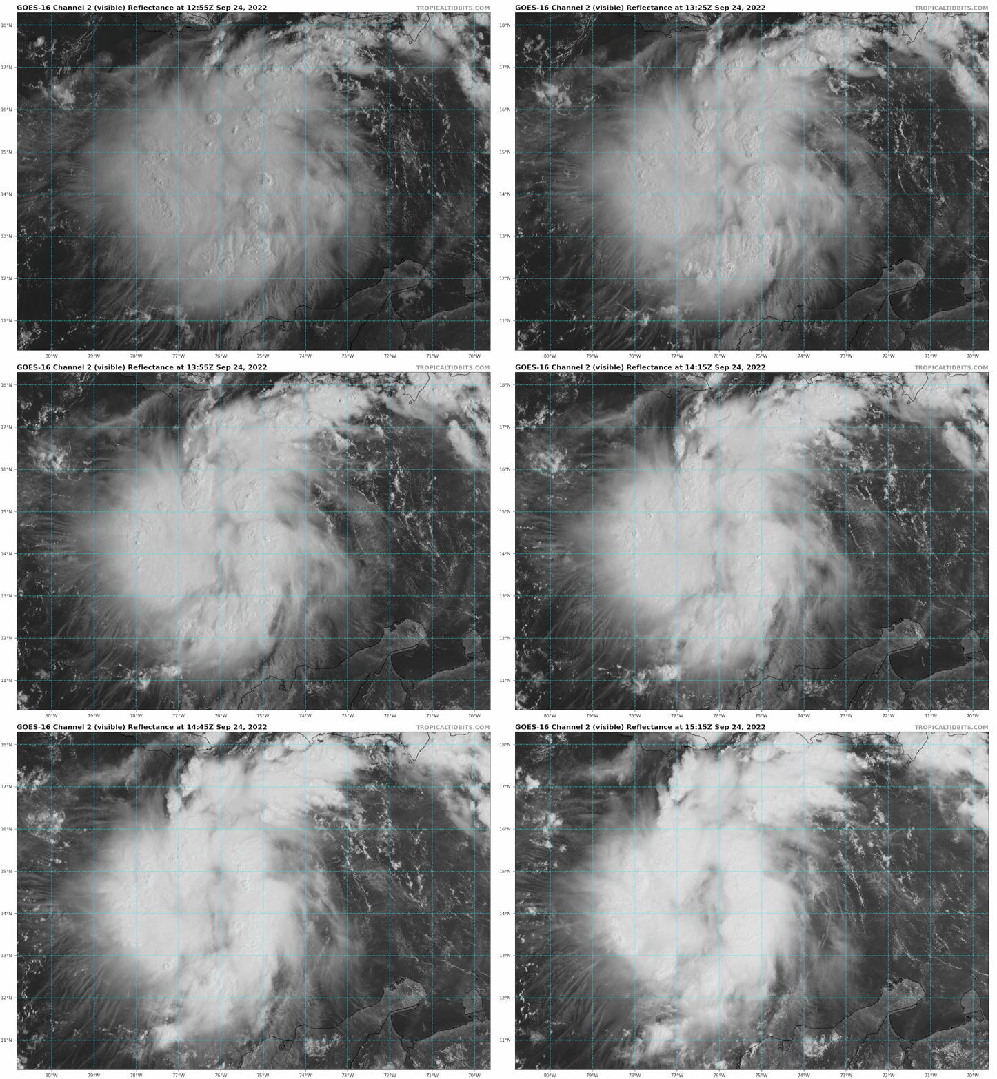
Image

Ian’s a bubbling! Blob kinda with more a NW hint past few frames. Large dry slot in the middle.
5 likes   
Hurricane Eye Experience: David 79, Irene 99, Frances 04, Jeanne 04, Wilma 05... EYE COMING MY WAY IN 2024…
Hurricane Brush Experience: Andrew 92, Erin 95, Floyd 99, Matthew 16, Irma 17, Ian 22, Nicole 22…

User avatar
NDG
S2K Supporter
S2K Supporter
Posts: 15425
Joined: Sun Jul 09, 2006 10:14 pm
Location: Orlando, FL

Re: ATL: IAN - Tropical Storm - Discussion

#967 Postby NDG » Sat Sep 24, 2022 10:29 am

wxman57 wrote:
NDG wrote:Officially from the NHC's latest discussion:
https://www.nhc.noaa.gov/text/refresh/M ... 1454.shtml
Limited land interaction is
expected as the cyclone quickly passes over western Cuba, and Ian
is forecast to be a major hurricane over the eastern Gulf of Mexico
on Tuesday and Wednesday as it approaches the west coast of Florida.


I personally think it will become a MH before crossing Cuba and stay as a MH as it approaches FL.


I'm not buying the MH into FL yet. Lots of wind shear in the NE Gulf that it will be fighting. Dry air, too. NHC may be erring on the high side to get the public to take action, not a bad move on their part. We may not even be certain where Ian will make landfall by Tuesday morning. Similar to Charley. Small changes in its heading will make a big difference in track. Fort Myers not out of the question, neither is eastern Panhandle.

Ok, I've been going solid for 6 hrs since 4:30am on Ian, Gaston, and Hermine. Time for a break.


We shall see as time gets closer, as we always say :D
You are not doing your 20 miles today on your bike?
3 likes   

Poonwalker
Category 1
Category 1
Posts: 270
Joined: Tue Sep 20, 2022 11:12 am

Re: ATL: IAN - Tropical Storm - Discussion

#968 Postby Poonwalker » Sat Sep 24, 2022 10:30 am

gatorcane wrote:
NDG wrote:Officially from the NHC's latest discussion:
https://www.nhc.noaa.gov/text/refresh/M ... 1454.shtml
Limited land interaction is
expected as the cyclone quickly passes over western Cuba, and Ian
is forecast to be a major hurricane over the eastern Gulf of Mexico
on Tuesday and Wednesday as it approaches the west coast of Florida.


I personally think it will become a MH before crossing Cuba and stay as a MH as it approaches FL.


Agreed


I agree also. I think a major in the GOM is going to be insulated for quite some time having those SST’s and water depth to work with prior to traversing the shelf. I would prepare for a cat 3 on the west coast of Florida.
1 likes   

User avatar
ScottNAtlanta
Category 5
Category 5
Posts: 2354
Joined: Sat May 25, 2013 3:11 pm
Location: Atlanta, GA

Re: ATL: IAN - Tropical Storm - Discussion

#969 Postby ScottNAtlanta » Sat Sep 24, 2022 10:30 am

I keep looking at recon and asking...Are we there yet?
3 likes   
The posts in this forum are NOT official forecast and should not be used as such. They are just the opinion of the poster and may or may not be backed by sound meteorological data. They are NOT endorsed by any professional institution or storm2k.org. For official information, please refer to the NHC and NWS products.

Mouton
S2K Supporter
S2K Supporter
Posts: 218
Age: 79
Joined: Sat Jul 30, 2011 8:13 am
Location: Amelia Island Florida

Re: ATL: IAN - Tropical Storm - Discussion

#970 Postby Mouton » Sat Sep 24, 2022 10:31 am

Two of the three parameters present for RI but what will be the venting. Right now, it looks like the north side will be sheared and include dry air intake after it leaves Cuba. Hopefully that is the case and the top end does not get to monstrous proportions. Most models show a back to the left bent after getting into the peninsula. Interesting.
Here in extreme NE Florida FWIW, barometric pressure has been rising quite a bit of late and it feels like the air is much drier than it has been in a long time. Yes,this is 3 to 4 days from when the storm should be near here but it does seem to show a building high.

Originally, I suspected a Charlie like path. I don't see that now, more a path left of Orlando and Lake City. 4-5 days out, many more nudges to make. :flag:
1 likes   

User avatar
ScottNAtlanta
Category 5
Category 5
Posts: 2354
Joined: Sat May 25, 2013 3:11 pm
Location: Atlanta, GA

Re: ATL: IAN - Tropical Storm - Discussion

#971 Postby ScottNAtlanta » Sat Sep 24, 2022 10:33 am

Blown Away wrote:[url]https://i.postimg.cc/rmnVMvN2/goes16-vis-09-L-202209241255.gif [/url]

Ian’s a bubbling! Blob kinda with more a NW hint past few frames. Large dry slot in the middle.

Levi posted a video a couple of days ago about the small distance between where the GFS and EURO placed Ian when it got close to the longitude of Jamaica. I am going to rewatch it to see where it is in regards to the video
3 likes   
The posts in this forum are NOT official forecast and should not be used as such. They are just the opinion of the poster and may or may not be backed by sound meteorological data. They are NOT endorsed by any professional institution or storm2k.org. For official information, please refer to the NHC and NWS products.

User avatar
Hypercane_Kyle
Category 5
Category 5
Posts: 3338
Joined: Sat Mar 07, 2015 7:58 pm
Location: Cape Canaveral, FL

Re: ATL: IAN - Tropical Storm - Discussion

#972 Postby Hypercane_Kyle » Sat Sep 24, 2022 10:33 am

Ian is certainly getting itself into a position to RI. Excellent upper-level environment and no longer has a sheared look.

My guess is we'll be looking at a much stronger TS by sunset.

Image
8 likes   
My posts are my own personal opinion, defer to the National Hurricane Center (NHC) and other NOAA products for decision making during hurricane season.

User avatar
ObsessedMiami
Category 1
Category 1
Posts: 431
Joined: Tue Aug 31, 2004 8:08 pm
Location: West Kendall, Fl

Re: ATL: IAN - Models

#973 Postby ObsessedMiami » Sat Sep 24, 2022 10:36 am

Patrick99 wrote:
boca wrote:
AutoPenalti wrote:I just heard from local news that SE Florida may dodge yet another bad storm.


Not sure how much I believe that.


We might only get outer band squalls out of this down here but I agree with the local met as well but it also depends on the size of the storm too.


We always do dodge them, don't we? Was looking forward to at least some squally weather to watch from the patio.....I should know better than to get my hopes up


I hate to say it every year but we have a lot of guests logging in to get information and I don’t think these “it is missing us” posts do anyone any good here. Just a thought
17 likes   

User avatar
ConvergenceZone
Category 5
Category 5
Posts: 5193
Joined: Fri Jul 29, 2005 1:40 am
Location: Northern California

Re: ATL: IAN - Tropical Storm - Discussion

#974 Postby ConvergenceZone » Sat Sep 24, 2022 10:37 am

wxman57 wrote:I have it inland near Tampa then northward, passing west of Jacksonville and into Georgia, where it dissipates. May be a comma-shaped storm in the Gulf with all that westerly shear.


That's awesome news wxman!! That's pretty much what I heard on the weather report this morning as well......."MAY" just be a tropical storm in the north-eastern gulf...But at least people would be prepared for the next big hurricane to hit, which could still happen this season since it's only the last part of September..............
Last edited by ConvergenceZone on Sat Sep 24, 2022 10:46 am, edited 1 time in total.
2 likes   

User avatar
aspen
Category 5
Category 5
Posts: 8789
Joined: Sat Oct 12, 2019 7:10 pm
Location: Connecticut, USA

Re: ATL: IAN - Tropical Storm - Discussion

#975 Postby aspen » Sat Sep 24, 2022 10:38 am

The NHC’s forecast looks a little faster than most of the models, which have been pushing back Ian’s Cuba landfall (or when it crosses Cuba’s latitude in the Yucatan Channel) to around 12z-15z Tuesday. Model runs from the previous 24-48+ hours had a landfall between 00z-06z Tuesday, some even a little earlier. An extra 12 hours in the exceptionally favorable WCar could significantly raise Ian’s intensity ceiling.
1 likes   
Irene '11 Sandy '12 Hermine '16 5/15/2018 Derecho Fay '20 Isaias '20 Elsa '21 Henri '21 Ida '21

I am only a meteorology enthusiast who knows a decent amount about tropical cyclones. Look to the professional mets, the NHC, or your local weather office for the best information.

psyclone
S2K Supporter
S2K Supporter
Posts: 4724
Joined: Wed Aug 24, 2005 9:04 pm
Location: palm harbor fl

Re: ATL: IAN - Tropical Storm - Discussion

#976 Postby psyclone » Sat Sep 24, 2022 10:39 am

Even a "non major" cane tracking just off the west coast would be a very bad set up for that surge prone region. a big evacuation will be needed if a decent storm takes that trajectory. we need a better deal. i was gunning for easterly shifts keeping us on the weak and dry side. is it shear and dry air to the rescue? we always get bailed out somehow...
7 likes   

underthwx
Category 5
Category 5
Posts: 2314
Joined: Sat Jul 30, 2011 2:14 pm
Location: Brazoria County Texas

Re: ATL: IAN - Tropical Storm - Discussion

#977 Postby underthwx » Sat Sep 24, 2022 10:44 am

psyclone wrote:Even a "non major" cane tracking just off the west coast would be a very bad set up for that surge prone region. a big evacuation will be needed if a decent storm takes that trajectory. we need a better deal. i was gunning for easterly shifts keeping us on the weak and dry side. is it shear and dry air to the rescue? we always get bailed out somehow...


A quick question. With Ian's predicted track, approaching Florida from the Southwest, which part of the cyclone contains the higher winds/rainfall?
1 likes   

User avatar
cheezyWXguy
Category 5
Category 5
Posts: 5968
Joined: Mon Feb 13, 2006 12:29 am
Location: Dallas, TX

Re: ATL: IAN - Tropical Storm - Discussion

#978 Postby cheezyWXguy » Sat Sep 24, 2022 10:47 am

psyclone wrote:Even a "non major" cane tracking just off the west coast would be a very bad set up for that surge prone region. a big evacuation will be needed if a decent storm takes that trajectory. we need a better deal. i was gunning for easterly shifts keeping us on the weak and dry side. is it shear and dry air to the rescue? we always get bailed out somehow...

Still up in the air. The way I see it, the NHC track is the dividing line between a sheared mess (left) and a potential major (right) at landfall. Taking a look at the gfs, hwrf, and icon, the storm is close to its peak intensity until about the latitude of Tampa, and then significantly weakens north of that line.
3 likes   

Sanibel
Category 5
Category 5
Posts: 10371
Joined: Mon Aug 30, 2004 11:06 pm
Location: Offshore SW Florida

ATL: IAN - Tropical Storm - Discussion

#979 Postby Sanibel » Sat Sep 24, 2022 11:11 am

Ian is in a formation phase where I'm having trouble locating the surface center to see which of the models was correct on whether the southern end of the wave would grab the center or northern...


To my eye, it looks like the rapidly-improving curvature is roughly starting to define the center...


If so, the trend is more towards GFS than Euro at this point with a verifying flat track towards the west Caribbean, which explains the models nicking left...


I'm guessing where Ian starts to turn north then becomes much more important than the trough...


The posts in this forum are NOT official forecasts and should not be used as such. They are just the opinion of the poster and may or may not be backed by sound meteorological data. They are NOT endorsed by any professional institution or STORM2K. For official information, please refer to products from the National Hurricane Center and National Weather Service.
3 likes   

User avatar
Weatherboy1
Category 5
Category 5
Posts: 1188
Age: 49
Joined: Mon Jul 05, 2004 1:50 pm
Location: Jupiter/Sarasota, FL

Re: ATL: IAN - Tropical Storm - Discussion

#980 Postby Weatherboy1 » Sat Sep 24, 2022 11:15 am

GFS just a WEE bit inconsistent… now forecasting landfall so far west, it’s almost out of Florida entirely! Geez
1 likes   


Return to “2022”

Who is online

Users browsing this forum: No registered users and 0 guests