ATL: IAN - Models
Moderator: S2k Moderators

Re: ATL: IAN - Models
Suggesting model initiation errors?
1 likes
Andy D
(For official information, please refer to the NHC and NWS products.)
(For official information, please refer to the NHC and NWS products.)

-
skillz305
- Category 1

- Posts: 312
- Joined: Sat Sep 08, 2018 11:10 am
- Location: Miami, Florida --> Vero Beach, Florida
Re: ATL: IAN - Models
HWRF 00z trending east compared to 18z so far
1 likes
 Hurricanes: Andrew 1992 - Irene 1999 - Frances 2004 - Jeanne 2004 - Katrina 2005 - Wilma 2005 - Matthew 2016 - Irma 2017 - Ian 2022 - Nicole 2022 - Milton 2024
Re: ATL: IAN - Models
BobHarlem wrote:https://twitter.com/figueroa_ii/status/1573901033016795137
References: https://www.nco.ncep.noaa.gov/idsb/nwpr ... mary.shtml
Just saw Derek post that. Yeah. Probably gonna have to dispense with this GFS run. It brings nothing new to the table and now's the time to start bringin' it!
2 likes
-
Stormcenter
- S2K Supporter

- Posts: 6689
- Joined: Wed Sep 03, 2003 11:27 am
- Location: Houston, TX
Re: ATL: IAN - Models
NHC does not mention that in their discussion so
I am skeptical if that is truly the case or not.
I am skeptical if that is truly the case or not.
NFLnut wrote:BobHarlem wrote:https://twitter.com/figueroa_ii/status/1573901033016795137
References: https://www.nco.ncep.noaa.gov/idsb/nwpr ... mary.shtml
Just saw Derek post that. Yeah. Probably gonna have to dispense with this GFS run. It brings nothing new to the table and now's the time to start bringin' it!
1 likes
Re: ATL: IAN - Models
Stormcenter wrote:NHC does not mention that in their discussion so
I am skeptical if that is truly the case or not.
Listed here:
https://www.nco.ncep.noaa.gov/idsb/nwpr ... mary.shtml
0 likes

Re: ATL: IAN - Models
I think the CMC has the best handle on synoptics and the best chance of verifying. The Euro looks to fast and the GFS seems out to lunch. I will call Cedar Key or a few miles North!
0 likes
The following post is NOT an official forecast and should not be used as such. It is just the opinion of the poster and may or may not be backed by sound meteorological data. It is NOT endorsed by any professional institution including storm2k.org For Official Information please refer to the NHC and NWS products.
-
Blown Away

- S2K Supporter
- Posts: 10253
- Joined: Wed May 26, 2004 6:17 am
Re: ATL: IAN - Models
blp wrote:Ukmet blue line. Port Charlotte.
https://uploads.disquscdn.com/images/aea86dfb6670422a921ad772941067af9047f9962cfd3679b09b57cb7d16197c.gif
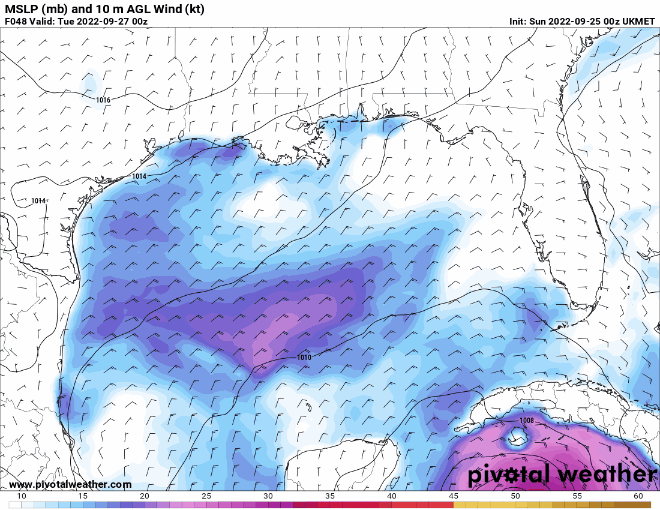
00z Ukmet
2 likes
Hurricane Eye Experience: David 79, Irene 99, Frances 04, Jeanne 04, Wilma 05… Hurricane Brush Experience: Andrew 92, Erin 95, Floyd 99, Matthew 16, Irma 17, Ian 22, Nicole 22…
-
Chris_in_Tampa
- Category 5

- Posts: 5101
- Age: 42
- Joined: Thu Jun 21, 2007 11:06 pm
- Location: Tampa, Florida, USA
- Contact:
Re: ATL: IAN - Models
NFLnut wrote:BobHarlem wrote:https://twitter.com/figueroa_ii/status/1573901033016795137
References: https://www.nco.ncep.noaa.gov/idsb/nwpr ... mary.shtml
Just saw Derek post that. Yeah. Probably gonna have to dispense with this GFS run. It brings nothing new to the table and now's the time to start bringin' it!
Link:
https://www.nco.ncep.noaa.gov/idsb/nwprod/realtime/
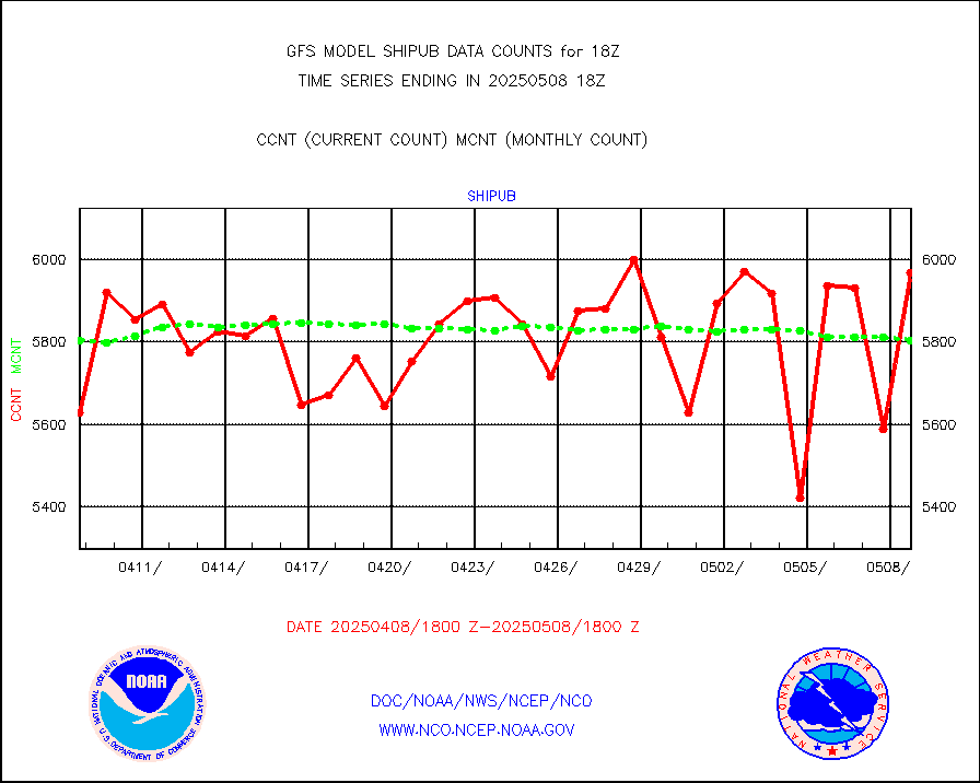
I don't know much about it, but for 18Z GFS:
https://www.nco.ncep.noaa.gov/idsb/nwpr ... mary.shtml
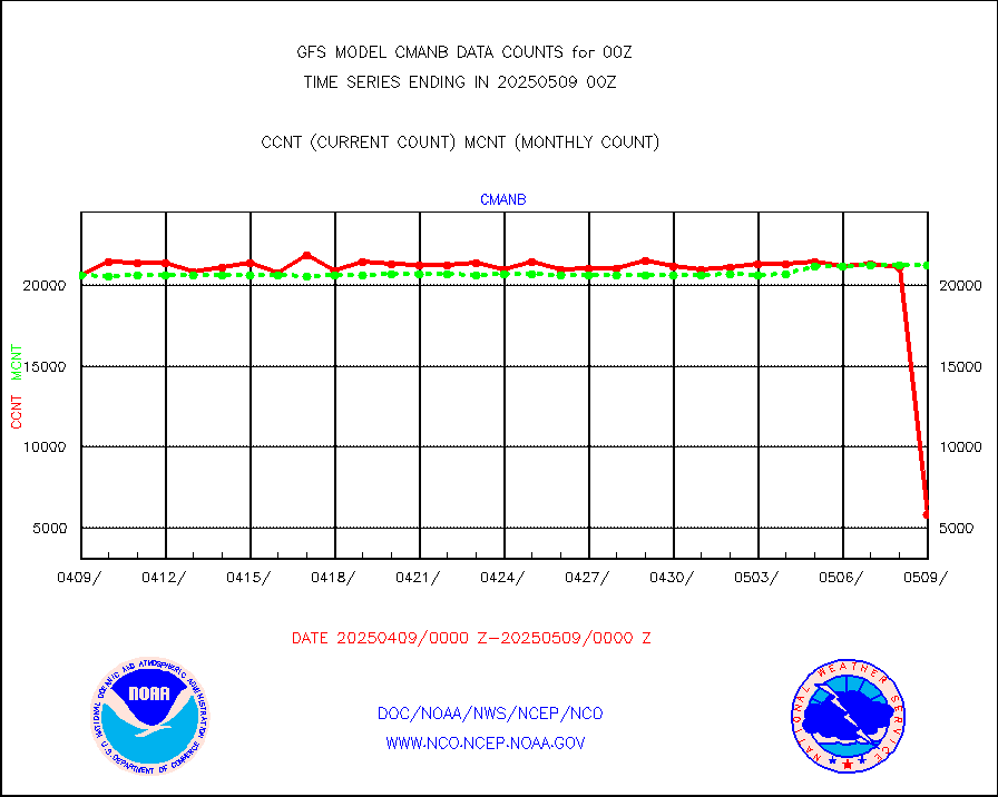
raobf
Rawinsonde - fixed land (from TEMP or PILOT)
Hourly Count: 82
Monthly Average: 35
For 0Z GFS:
https://www.nco.ncep.noaa.gov/idsb/nwpr ... mary.shtml
raobf
Rawinsonde - fixed land (from TEMP or PILOT)
Hourly Count: 592
Monthly Average: 601
So 18Z special I would assume went into 18Z GFS since on that chart the number sky rockets. Don't know.
0Z would have normal ones, so around average number. There are no special ones for those times.
Charts:
18Z:
https://www.nco.ncep.noaa.gov/idsb/nwpr ... fs.020.gif
Only for 18Z on that chart, not other runs.
0Z:
https://www.nco.ncep.noaa.gov/idsb/nwpr ... fs.019.gif
Only for 0Z on that chart, not other runs.
Admin status message from a few days ago:
NOUS42 KWNO 231356
ADMSDM
SENIOR DUTY METEOROLOGIST NWS ADMINISTRATIVE MESSAGE
NWS NCEP CENTRAL OPERATIONS COLLEGE PARK MD
1354Z FRI SEP 23 2022
The 12Z NCEP model production suite is currently running on time.
12Z NAM RAOB RECAP...
71109/YZT - Purged temp/moisture 660-622mb...wet bulb effect
70026/BRW - 10142
70200/OME - 10142
70361/YAK - Short to 661mb
72214/TAE - 10148
72469/DNR - 10159
76595/CUN - 10142
78970/POS - 10142
SPECIAL SOUNDINGS IN SUPPORT OF TD 9...
Special 06Z/18Z soundings have been requested starting ASAP for:
TAE, JAX, TBW, MFL, EYW.
Special 06Z/18Z soundings have been requested starting 18Z
Saturday for:
-All Eastern Region sites
-All Southern Region sites, excluding EPZ and ABQ
-The following Central Region sites: BIS, UNR, ABR, LBF, OAX,
DDC, TOP, SGF, ILX, DVN, MPX, INL, GRB
CRITICAL WEATHER DAY STATUS...
CWD is not currently in effect. However, NCEP continues to
closely monitor and assess the need for CWD with Hurricane Fiona
moving into Atlantic Canada this weekend and TD Nine possibly
tracking into the southeastern Gulf of Mexico early next week.
Gerhardt/SDM/NCO/NCEP
Direct link to single message:
https://forecast.weather.gov/product.ph ... suedby=SDM
Link to last 50 on one page:
https://www.nco.ncep.noaa.gov/status/messages/
Last edited by Chris_in_Tampa on Sun Sep 25, 2022 1:16 am, edited 1 time in total.
2 likes
Re: ATL: IAN - Models
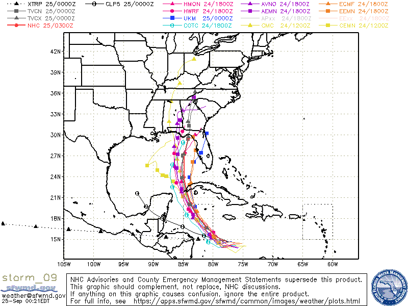
Euro is Cat 1 at 72 hrs when NHC has it at Cat 4. I didn't look at GFS last run but it can't be that much stronger at 72 to make NHC pump this up so much? Seems with the terribly disorganized storm at this point that they made need to drop their intensities. Unless if it bombs the next 24 hours.
2 likes
Re: ATL: IAN - Models
0Z Euro 72 is only barely N of the 18Z Euro 78.
1 likes
Personal Forecast Disclaimer:
The posts in this forum are NOT official forecasts and should not be used as such. They are just the opinion of the poster and may or may not be backed by sound meteorological data. They are NOT endorsed by any professional institution or storm2k.org. For official information, please refer to the NHC and NWS products.
The posts in this forum are NOT official forecasts and should not be used as such. They are just the opinion of the poster and may or may not be backed by sound meteorological data. They are NOT endorsed by any professional institution or storm2k.org. For official information, please refer to the NHC and NWS products.

Re: ATL: IAN - Models
NFLnut wrote:Euro is Cat 1 at 72 hrs when NHC has it at Cat 4. I didn't look at GFS last run but it can't be that much stronger at 72 to make NHC pump this up so much? Seems with the terribly disorganized storm at this point that they made need to drop their intensities. Unless if it bombs the next 24 hours.
Euro has a significant weak bias and almost always underdoes intensity. It should not be used for intensity forecasts verbatim (nor should most global models in general).
2 likes
TC naming lists: retirements and intensity
Most aggressive Advisory #1's in North Atlantic (cr. kevin for starting the list)
Most aggressive Advisory #1's in North Atlantic (cr. kevin for starting the list)
-
AtlanticWind

- S2K Supporter
- Posts: 1898
- Age: 67
- Joined: Sun Aug 08, 2004 9:57 pm
- Location: Plantation,Fla
Re: ATL: IAN - Models
0Z Euro landfall just S of Tampa at 96.
1 likes
Personal Forecast Disclaimer:
The posts in this forum are NOT official forecasts and should not be used as such. They are just the opinion of the poster and may or may not be backed by sound meteorological data. They are NOT endorsed by any professional institution or storm2k.org. For official information, please refer to the NHC and NWS products.
The posts in this forum are NOT official forecasts and should not be used as such. They are just the opinion of the poster and may or may not be backed by sound meteorological data. They are NOT endorsed by any professional institution or storm2k.org. For official information, please refer to the NHC and NWS products.
-
chris_fit

- Category 5
- Posts: 3261
- Age: 43
- Joined: Wed Sep 10, 2003 11:58 pm
- Location: Tampa Bay Area, FL
Re: ATL: IAN - Models
00Z Euro slightly faster and S/E of 12Z and 18Z - Seems to go more inland

2 likes
-
Blown Away
- S2K Supporter
- Posts: 10253
- Joined: Wed May 26, 2004 6:17 am
Re: ATL: IAN - Models
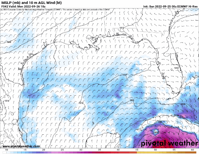
00z ECMWF… Holds serve, landfall just south of Tampa and SE shift from 12z…
Last edited by Blown Away on Sun Sep 25, 2022 1:30 am, edited 1 time in total.
3 likes
Hurricane Eye Experience: David 79, Irene 99, Frances 04, Jeanne 04, Wilma 05… Hurricane Brush Experience: Andrew 92, Erin 95, Floyd 99, Matthew 16, Irma 17, Ian 22, Nicole 22…

Re: ATL: IAN - Models
Euro is sticking to its landfall near Tampa Bay, if anything it trended a little east. Hope residents along the west coast of FL from Tampa Bay on south didn’t let their guards down.
3 likes

Who is online
Users browsing this forum: No registered users and 21 guests