ATL: IAN - Post-Tropical - Discussion

Moderator: S2k Moderators

Message
Author
Visioen
S2K Supporter
S2K Supporter
Posts: 286
Joined: Sat Sep 02, 2017 2:08 pm
Location: Belgium, Europe

Re: ATL: IAN - Tropical Storm - Discussion

#1301 Postby Visioen » Sun Sep 25, 2022 7:25 am

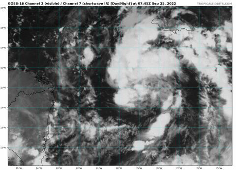
wxman57 wrote:I'd look north of 15N for the center. That stuff down south is insignificant. Strong mid-level center around 15.5N. Surface center will form/relocate there. Still looks like northern FL Peninsula, north of Tampa. NHC is now acknowledging the strong shear that would lead to weakening prior to landfall. However, the farther (farther = distance, not "further") south it impacts Florida, the stronger it would be at landfall. My track is east of their track (along TVCN) because TVCN is likely being pulled too far west by the errant (likely) GFS and HWRF. Starting on advisory...

I think waxman is spot on this time, makes a lot of sense.
6 likes   

User avatar
toad strangler
S2K Supporter
S2K Supporter
Posts: 4543
Joined: Sun Jul 28, 2013 3:09 pm
Location: Earth
Contact:

Re: ATL: IAN - Tropical Storm - Discussion

#1302 Postby toad strangler » Sun Sep 25, 2022 7:30 am

Chances rising for a peninsula hit over panhandle. Question is where? wxman57’s comment about the farther south on the peninsula the stronger the storm is a bit disconcerting.

I also wonder now if the chance of a crossing the peninsula and riding the east coast possibility is getting better as well?
6 likes   

User avatar
StPeteMike
Category 2
Category 2
Posts: 631
Joined: Thu Jun 07, 2018 11:26 pm

Re: ATL: IAN - Tropical Storm - Discussion

#1303 Postby StPeteMike » Sun Sep 25, 2022 7:34 am

toad strangler wrote:Chances rising for a peninsula hit over panhandle. Question is where? wxman57’s comment about the farther south on the peninsula the stronger the storm is a bit disconcerting.

I also wonder now if the chance of a crossing the peninsula and riding the east coast possibility is getting better as well?

Seems like the models that aim towards the peninsula also make a more north turn once it gets to the coast or just inland. How drastic of a turn I can’t really answer. Think this will go up into S Georgia and then the Carolinas, but all inland.
1 likes   
The above post is not official and should not be used as such. It is the opinion of the poster and may or may not be backed by sound meteorological data. It is not endorsed by any professional institution or storm2k.org. For official information, please refer to the NHC and NWS products.

BobHarlem
Category 5
Category 5
Posts: 2108
Joined: Thu Oct 20, 2005 6:11 pm

Re: ATL: IAN - Tropical Storm - Discussion

#1304 Postby BobHarlem » Sun Sep 25, 2022 7:38 am

StPeteMike wrote:
toad strangler wrote:Chances rising for a peninsula hit over panhandle. Question is where? wxman57’s comment about the farther south on the peninsula the stronger the storm is a bit disconcerting.

I also wonder now if the chance of a crossing the peninsula and riding the east coast possibility is getting better as well?

Seems like the models that aim towards the peninsula also make a more north turn once it gets to the coast or just inland. How drastic of a turn I can’t really answer. Think this will go up into S Georgia and then the Carolinas, but all inland.


Just offshore coast raker then in around Cedar Key is what I think at the moment (Will probably change... not a forecast)
2 likes   

shannalynn35
Tropical Wave
Tropical Wave
Posts: 4
Joined: Tue Sep 20, 2022 8:08 am

Re: ATL: IAN - Tropical Storm - Discussion

#1305 Postby shannalynn35 » Sun Sep 25, 2022 7:39 am

Good morning everyone! I have been watching closely and live in the Tampa Bay Area just 20 minutes south of St. Pete in Bradenton and the Euro is giving me major anxiety I’m born and raised here so I’ve had my share of TS and Hurricanes but nothing with a direct landfall, being a newbie to this group can someone explain why the Euro stays so consistent with staying more east and eyeing the Tampa Bay Area? Sorry for my lack of knowledge!!
1 likes   

User avatar
ColdMiser123
Professional-Met
Professional-Met
Posts: 904
Age: 29
Joined: Mon Sep 26, 2016 3:26 pm
Location: Northeast US

Re: ATL: IAN - Tropical Storm - Discussion

#1306 Postby ColdMiser123 » Sun Sep 25, 2022 7:44 am

Ian has made the turn NW according to the last two recon passes, looks a tad NW of where the 12 hour 0z Euro forecast placed the low center. Models much closer now to where the low center currently is.
9 likes   
B.S., M.S., Meteorology & Atmospheric Science

User avatar
StPeteMike
Category 2
Category 2
Posts: 631
Joined: Thu Jun 07, 2018 11:26 pm

Re: ATL: IAN - Tropical Storm - Discussion

#1307 Postby StPeteMike » Sun Sep 25, 2022 7:52 am

shannalynn35 wrote:Good morning everyone! I have been watching closely and live in the Tampa Bay Area just 20 minutes south of St. Pete in Bradenton and the Euro is giving me major anxiety I’m born and raised here so I’ve had my share of TS and Hurricanes but nothing with a direct landfall, being a newbie to this group can someone explain why the Euro stays so consistent with staying more east and eyeing the Tampa Bay Area? Sorry for my lack of knowledge!!

Includes a faster forward speed the next couple days compared to the GFS is the main reason, allowing the trough to have some influence on the direction before it pulls out and gives Ian less steering influence. GFS has it slower and totally misses the trough.
1 likes   
The above post is not official and should not be used as such. It is the opinion of the poster and may or may not be backed by sound meteorological data. It is not endorsed by any professional institution or storm2k.org. For official information, please refer to the NHC and NWS products.

User avatar
Blown Away
S2K Supporter
S2K Supporter
Posts: 10145
Joined: Wed May 26, 2004 6:17 am

Re: ATL: IAN - Tropical Storm - Discussion

#1308 Postby Blown Away » Sun Sep 25, 2022 7:56 am

ColdMiser123 wrote:Ian has made the turn NW according to the last two recon passes, looks a tad NW of where the 12 hour 0z Euro forecast placed the low center. Models much closer now to where the low center currently is.


Can you provide a graphic or lat/long of this position? Does the NW position imply moving faster compared to 12 hr 00z?
1 likes   
Hurricane Eye Experience: David 79, Irene 99, Frances 04, Jeanne 04, Wilma 05... EYE COMING MY WAY IN 2024…
Hurricane Brush Experience: Andrew 92, Erin 95, Floyd 99, Matthew 16, Irma 17, Ian 22, Nicole 22…

User avatar
wxman57
Moderator-Pro Met
Moderator-Pro Met
Posts: 22978
Age: 67
Joined: Sat Jun 21, 2003 8:06 pm
Location: Houston, TX (southwest)

Re: ATL: IAN - Tropical Storm - Discussion

#1309 Postby wxman57 » Sun Sep 25, 2022 7:57 am

No change in 12Z consensus = no change in NHC's 15Z track. I still think it'll be east of their track around Tampa and northward. Consensus is biased too far west by GFS/HWFF.
12 likes   

User avatar
Nimbus
Category 5
Category 5
Posts: 5300
Joined: Mon Jul 19, 2004 10:54 am

Re: ATL: IAN - Tropical Storm - Discussion

#1310 Postby Nimbus » Sun Sep 25, 2022 8:00 am

ColdMiser123 wrote:Ian has made the turn NW according to the last two recon passes, looks a tad NW of where the 12 hour 0z Euro forecast placed the low center. Models much closer now to where the low center currently is.


Longer term Ian is about a degree south of where the models predicted at the 72 hour range.
Mid level center is near 15N -75.8W and there still could be mesovorts rotating around so at least using a 3 hour average of track direction is probably safer.
2 likes   

User avatar
ColdMiser123
Professional-Met
Professional-Met
Posts: 904
Age: 29
Joined: Mon Sep 26, 2016 3:26 pm
Location: Northeast US

Re: ATL: IAN - Tropical Storm - Discussion

#1311 Postby ColdMiser123 » Sun Sep 25, 2022 8:01 am

Blown Away wrote:
ColdMiser123 wrote:Ian has made the turn NW according to the last two recon passes, looks a tad NW of where the 12 hour 0z Euro forecast placed the low center. Models much closer now to where the low center currently is.


Can you provide a graphic or lat/long of this position? Does the NW position imply moving faster compared to 12 hr 00z?


I have the coordinates of the 12 hour 0z Euro forecast to be 14.8N/79.3W, compared to the 8 am/12z NHC position of 15.0N/79.4W. Any kind of track difference now will be related to how the models interact with the trough in the Gulf.
Last edited by ColdMiser123 on Sun Sep 25, 2022 8:02 am, edited 2 times in total.
2 likes   
B.S., M.S., Meteorology & Atmospheric Science

BobHarlem
Category 5
Category 5
Posts: 2108
Joined: Thu Oct 20, 2005 6:11 pm

Re: ATL: IAN - Tropical Storm - Discussion

#1312 Postby BobHarlem » Sun Sep 25, 2022 8:01 am

wxman57 wrote:No change in 12Z consensus = no change in NHC's 15Z track. I still think it'll be east of their track around Tampa and northward. Consensus is biased too far west by GFS/HWFF.


Would they manually adjust it just east of the TVCN to avoid taking the cone out of Ft. Myers? With the Euro's persistence I'd think about doing that. Is it going to be close enough to St Pete/Tampa to cause a bunch of issues even if landfall is north of there?
1 likes   

User avatar
Teban54
Category 5
Category 5
Posts: 3206
Joined: Sat May 19, 2018 1:19 pm

Re: ATL: IAN - Tropical Storm - Discussion

#1313 Postby Teban54 » Sun Sep 25, 2022 8:03 am

0 likes   

Tailgater33
Tropical Depression
Tropical Depression
Posts: 87
Joined: Thu Jun 02, 2022 9:15 am

Re: ATL: IAN - Tropical Storm - Discussion

#1314 Postby Tailgater33 » Sun Sep 25, 2022 8:06 am

Yep center at 15.1N it’ll start deepening now, Tampa home owners will likely be wishing they had a shield.
I hope the shear gets to it earlier than forecast
2 likes   

User avatar
Weatherboy1
Category 5
Category 5
Posts: 1189
Age: 49
Joined: Mon Jul 05, 2004 1:50 pm
Location: Jupiter/Sarasota, FL

Re: ATL: IAN - Tropical Storm - Discussion

#1315 Postby Weatherboy1 » Sun Sep 25, 2022 8:09 am

While Ian still doesn’t have a central core of intense convection, the overall satellite presentation is very impressive. Lots of banding, etc.
3 likes   

User avatar
REDHurricane
Category 1
Category 1
Posts: 396
Age: 27
Joined: Sun Jul 03, 2022 2:36 pm
Location: Northeast Pacific Ocean

Re: ATL: IAN - Tropical Storm - Discussion

#1316 Postby REDHurricane » Sun Sep 25, 2022 8:18 am

Looks like rotation is beginning to consolidate somewhere around 15-15.5ºN, 79.5ºW

Image

Vorticity is starting to fully stack up as well

Image

Image

The setup is all there for RI right now, let's see if Ian will really ramp up soon as expected. Will this be a relatively simple situation where more intense storm = more NE track, or does the interaction with the trough further complicate things?
5 likes   

caneman
Category 5
Category 5
Posts: 1447
Joined: Fri Sep 05, 2014 5:44 am
Location: Clearwater Beach, Fl

Re: ATL: IAN - Tropical Storm - Discussion

#1317 Postby caneman » Sun Sep 25, 2022 8:20 am

BobHarlem wrote:
wxman57 wrote:No change in 12Z consensus = no change in NHC's 15Z track. I still think it'll be east of their track around Tampa and northward. Consensus is biased too far west by GFS/HWFF.


Agree I would hope they'd move it East some so as not to give a false sense of security. In addition, if it really does go East there would be far less time and a stronger Hurricane

Would they manually adjust it just east of the TVCN to avoid taking the cone out of Ft. Myers? With the Euro's persistence I'd think about doing that. Is it going to be close enough to St Pete/Tampa to cause a bunch of issues even if landfall is north of there?
2 likes   

User avatar
johngaltfla
Category 5
Category 5
Posts: 2069
Joined: Sun Jul 10, 2005 9:17 pm
Location: Sarasota County, FL
Contact:

Re: ATL: IAN - Tropical Storm - Discussion

#1318 Postby johngaltfla » Sun Sep 25, 2022 8:20 am

wxman57 wrote:No change in 12Z consensus = no change in NHC's 15Z track. I still think it'll be east of their track around Tampa and northward. Consensus is biased too far west by GFS/HWFF.


If we are talking about anything in/on the Pinellas County area, the NHC and Florida government will have to act this afternoon or at a minimum early this evening. To evacuate those vulnerable coastal areas will take 2 days at a minimum.

And with a gulf storm approaching from the southwest, there is no guarantee it will weaken at landfall. It is too early in the game to tell.
6 likes   

User avatar
ObsessedMiami
Category 1
Category 1
Posts: 431
Joined: Tue Aug 31, 2004 8:08 pm
Location: West Kendall, Fl

Re: ATL: IAN - Tropical Storm - Discussion

#1319 Postby ObsessedMiami » Sun Sep 25, 2022 8:22 am

Would not want to be in Tampa emergency managements shoes with the uncertainty of the track vs the potential risks of waiting for clearer guidance.
2 likes   

Gatos del Sol
Tropical Low
Tropical Low
Posts: 17
Joined: Fri Sep 23, 2022 8:42 pm
Location: Niceville, FL

Re: ATL: IAN - Tropical Storm - Discussion

#1320 Postby Gatos del Sol » Sun Sep 25, 2022 8:23 am

BobHarlem wrote:
Just offshore coast raker then in around Cedar Key is what I think at the moment (Will probably change... not a forecast)


A Cedar Key raker could end up being pretty bad for Tampa Bay depending on the approach angle due to funneling concerns. The South Tampa peninsula area is heavily populated and very low lying. Surge/evacuation maps for Hillsborough County-

https://www.tbrpc.org/wp-content/upload ... p-Side.pdf
3 likes   


Return to “2022”

Who is online

Users browsing this forum: No registered users and 16 guests