ATL: IAN - Post-Tropical - Discussion
Moderator: S2k Moderators
-
ElectricStorm

- Category 5

- Posts: 5147
- Age: 25
- Joined: Tue Aug 13, 2019 11:23 pm
- Location: Norman, OK
Re: ATL: IAN - Tropical Storm - Discussion
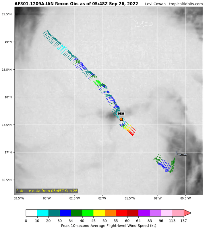
Eye drop 989/13, that supports the NHC's 988
2 likes
B.S Meteorology, University of Oklahoma '25
Please refer to the NHC, NWS, or SPC for official information.
Please refer to the NHC, NWS, or SPC for official information.

Re: ATL: IAN - Tropical Storm - Discussion
There's a blob of recon data missing on TT:
Did the 60 kt upgrade come from this (meaning they weren't transmitted to the public for some reason), or was it based on the assumption that stronger winds are in the NE quad?
Edit: The missing data is up now. 62 kt FL, but SFMR lower than earlier. So probably the latter.
Did the 60 kt upgrade come from this (meaning they weren't transmitted to the public for some reason), or was it based on the assumption that stronger winds are in the NE quad?
Edit: The missing data is up now. 62 kt FL, but SFMR lower than earlier. So probably the latter.
2 likes
TC naming lists: retirements and intensity
Most aggressive Advisory #1's in North Atlantic (cr. kevin for starting the list)
Most aggressive Advisory #1's in North Atlantic (cr. kevin for starting the list)
-
Craters
- Category 1

- Posts: 428
- Joined: Sat Aug 24, 2013 2:34 pm
- Location: Alvin, TX (south of Houston)
Re: ATL: IAN - Tropical Storm - Discussion
Dang. I'm looking at the long-wave IR loop on COD, and I can't tell that Ian is moving at ALL. Wow.
Guess I'm not very tight with long-wave IR radiation or something...
Guess I'm not very tight with long-wave IR radiation or something...
1 likes
Nothing that I post here should ever be treated as a forecast or anything resembling one. Please check with your local NWS office or the NHC for forecasts, watches, and warnings.

Re: ATL: IAN - Tropical Storm - Discussion
I really thought I’d have more clarity on this storm/the track by tonight, but I guess that just won’t be the case
3 likes
-
ElectricStorm
- Category 5
- Posts: 5147
- Age: 25
- Joined: Tue Aug 13, 2019 11:23 pm
- Location: Norman, OK
Re: ATL: IAN - Tropical Storm - Discussion
Extrap 985 this pass, hurricane force FL winds in E quad but SFMR hasn't caught up
1 likes
B.S Meteorology, University of Oklahoma '25
Please refer to the NHC, NWS, or SPC for official information.
Please refer to the NHC, NWS, or SPC for official information.
Re: ATL: IAN - Tropical Storm - Discussion
cheezyWXguy wrote:ElectricStorm wrote:Extrap 988, so not much different from the last mission. Interesting that the FL winds on the N/NW side are pretty weak this pass
Tentatively, I’m not so sure. It looks like they just missed the center, judging by the sfmr not dropping below 10kt and immediately shooting back up. I’m tempted to think it’s similar to that second pass they did on the last flight where it looked like the pressure rose. But if the next pass shows a similar pressure then I concede.
Edit: another reason the pressure may be valid is that winds in the nw quad are very unimpressive. The asymmetry of the wind field suggests Ian still has some kinks to work out
Looks like the low NW quad may be because the eyewall is open there.
The first VDM also shows a C36 eye, much larger than the 15 nm eye from the last mission.
Last edited by Teban54 on Mon Sep 26, 2022 2:19 am, edited 1 time in total.
2 likes
TC naming lists: retirements and intensity
Most aggressive Advisory #1's in North Atlantic (cr. kevin for starting the list)
Most aggressive Advisory #1's in North Atlantic (cr. kevin for starting the list)
-
ElectricStorm
- Category 5
- Posts: 5147
- Age: 25
- Joined: Tue Aug 13, 2019 11:23 pm
- Location: Norman, OK
Re: ATL: IAN - Tropical Storm - Discussion
Eye drop 986/13, supports 985
1 likes
B.S Meteorology, University of Oklahoma '25
Please refer to the NHC, NWS, or SPC for official information.
Please refer to the NHC, NWS, or SPC for official information.
-
Jelmergraaff
- Tropical Storm

- Posts: 138
- Age: 23
- Joined: Fri Aug 27, 2021 1:00 pm
- Location: The Netherlands
Re: ATL: IAN - Tropical Storm - Discussion
ElectricStorm wrote:Extrap 985 this pass, hurricane force FL winds in E quad but SFMR hasn't caught up
Eye drop had 986mb with 13kt.

2 likes
21-year old meteorologist and student MSc Climate Studies from The Netherlands. Interested in all fields of meteorology and climatology, including tropical systems like hurricanes.
Re: ATL: IAN - Tropical Storm - Discussion
Last edited by Teban54 on Mon Sep 26, 2022 1:50 am, edited 1 time in total.
2 likes
TC naming lists: retirements and intensity
Most aggressive Advisory #1's in North Atlantic (cr. kevin for starting the list)
Most aggressive Advisory #1's in North Atlantic (cr. kevin for starting the list)

Re: ATL: IAN - Tropical Storm - Discussion
Hurricane. 65kt/985mb
AL, 09, 2022092606, , BEST, 0, 177N, 817W, 65, 985, HU, 64, NEQ, 15, 0, 0, 0, 1007, 150, 15, 0, 0, L, 0, , 0, 0, IAN, D, 0, , 0, 0, 0, 0, genesis-num, 028,
5 likes
-
cheezyWXguy

- Category 5
- Posts: 6282
- Joined: Mon Feb 13, 2006 12:29 am
- Location: Dallas, TX
Re: ATL: IAN - Tropical Storm - Discussion
Landy wrote:Hurricane. 65kt/985mbAL, 09, 2022092606, , BEST, 0, 177N, 817W, 65, 985, HU, 64, NEQ, 15, 0, 0, 0, 1007, 150, 15, 0, 0, L, 0, , 0, 0, IAN, D, 0, , 0, 0, 0, 0, genesis-num, 028,
Woah, didn’t think they’d upgrade on it just yet. 71kt FL technically gets it there, but sfmr hasn’t quite caught up.
3 likes
-
CrazyC83
- Professional-Met

- Posts: 34315
- Joined: Tue Mar 07, 2006 11:57 pm
- Location: Deep South, for the first time!
Re: ATL: IAN - Tropical Storm - Discussion
cheezyWXguy wrote:Landy wrote:Hurricane. 65kt/985mbAL, 09, 2022092606, , BEST, 0, 177N, 817W, 65, 985, HU, 64, NEQ, 15, 0, 0, 0, 1007, 150, 15, 0, 0, L, 0, , 0, 0, IAN, D, 0, , 0, 0, 0, 0, genesis-num, 028,
Woah, didn’t think they’d upgrade on it just yet. 71kt FL technically gets it there, but sfmr hasn’t quite caught up.
I am a bit surprised too given the SFMR. A blend of the data is 60 kt.
2 likes
-
Sciencerocks
- Category 5
- Posts: 10186
- Age: 40
- Joined: Thu Jul 06, 2017 1:51 am

-
ElectricStorm
- Category 5
- Posts: 5147
- Age: 25
- Joined: Tue Aug 13, 2019 11:23 pm
- Location: Norman, OK
Re: ATL: IAN - Tropical Storm - Discussion
Another thing to watch out for is the tornado threat, a couple slight risks up from SPC.
Tues 9/27


Wed 9/28

Tues 9/27
Wed 9/28
3 likes
B.S Meteorology, University of Oklahoma '25
Please refer to the NHC, NWS, or SPC for official information.
Please refer to the NHC, NWS, or SPC for official information.
-
Hurrilurker

- Category 2

- Posts: 738
- Joined: Mon Jun 09, 2003 3:32 pm
- Location: San Francisco, CA
Re: ATL: IAN - Tropical Storm - Discussion
I don’t understand how they have TS watch up for south FL but no watches or warnings up for central FL. Shouldn’t there be at least a TS if not H watch for the whole FL West coast by now?
3 likes
-
AtlanticWind

- S2K Supporter

- Posts: 1898
- Age: 67
- Joined: Sun Aug 08, 2004 9:57 pm
- Location: Plantation,Fla
Re: ATL: IAN - Tropical Storm - Discussion
Hurrilurker wrote:I don’t understand how they have TS watch up for south FL but no watches or warnings up for central FL. Shouldn’t there be at least a TS if not H watch for the whole FL West coast by now?
There will be later this morning,, watches and warnings will be issued as the storm moves north.
3 likes

Re: ATL: IAN - Tropical Storm - Discussion
Hurrilurker wrote:I don’t understand how they have TS watch up for south FL but no watches or warnings up for central FL. Shouldn’t there be at least a TS if not H watch for the whole FL West coast by now?
I would figure the would err on the side of caution and give the lower Florida Keys hurricane warning, upper Keys TStorm warnings but as of 11pm the lower Keys are under a tropical storm warning.
While my location bias certainly is a factor, only a couple of wobbles right and Key West will be getting hurricane conditions.
1 likes

Re: ATL: IAN - Tropical Storm - Discussion
Interlocking band eye forming? Overall cloud orientation becoming south-north: indicating northward motion soon?
1 likes
List of 79 tropical cyclones intercepted by Richard Horodner:
http://www.canebeard.com/page/page/572246.htm
former storm2k screenname Beoumont 2009+
http://www.canebeard.com/page/page/572246.htm
former storm2k screenname Beoumont 2009+
-
Bocadude85

- Category 5
- Posts: 2991
- Age: 39
- Joined: Mon Apr 18, 2005 2:20 pm
- Location: Honolulu,Hi
Re: ATL: IAN - Tropical Storm - Discussion
canebeard wrote:Interlocking band eye forming? Overall cloud orientation becoming south-north: indicating northward motion soon?
If you look at the last recon fixes the center was moving a little more north of northwest
1 likes
Re: ATL: IAN - Tropical Storm - Discussion
Teban54 wrote:cheezyWXguy wrote:ElectricStorm wrote:Extrap 988, so not much different from the last mission. Interesting that the FL winds on the N/NW side are pretty weak this pass
Tentatively, I’m not so sure. It looks like they just missed the center, judging by the sfmr not dropping below 10kt and immediately shooting back up. I’m tempted to think it’s similar to that second pass they did on the last flight where it looked like the pressure rose. But if the next pass shows a similar pressure then I concede.
Edit: another reason the pressure may be valid is that winds in the nw quad are very unimpressive. The asymmetry of the wind field suggests Ian still has some kinks to work out
Looks like the low NW quad may be because the eyewall is open there.
The first VDM also shows a C36 eye, much larger than the 15 nm eye from the last mission.
What's a C36 eye?
2 likes
Who is online
Users browsing this forum: No registered users and 26 guests