
My case in point. Brian says it’s unusual for this time of year. Meaning, he’s not saying a hurricane or ts is definitely going to happen. But he’s not ignoring the GFS and other supporting models either. He is sticking with both sides of the data as it comes in. the word for weather in Latin means change so there’s no room for dogmaticism.
ATL: NICOLE - Post-Tropical - Discussion
Moderator: S2k Moderators
Re: ATL: INVEST 98L - Discussion
My case in point. Brian says it’s unusual for this time of year. Meaning, he’s not saying a hurricane or ts is definitely going to happen. But he’s not ignoring the GFS and other supporting models either. He is sticking with both sides of the data as it comes in. the word for weather in Latin means change so there’s no room for dogmaticism.
6 likes
Robbielyn McCrary
I know just about enough to sound like I know what I'm talking about sometimes. But for your safety please follow the nhc for truly professional forecasting.
I know just about enough to sound like I know what I'm talking about sometimes. But for your safety please follow the nhc for truly professional forecasting.
-
MarioProtVI
- Category 5

- Posts: 1034
- Age: 24
- Joined: Sun Sep 29, 2019 7:33 pm
- Location: New Jersey
Re: ATL: INVEST 98L - Discussion
The more time goes on the more I think this is really trying to be like Kate 1985… both are expected/ended up forming from non-/subtropical origins, unusually warm SSTs with similar high pressure locations (sitting off SE coast), and identical strength (moderate hurricane) into Florida. Is 2022 trying to be 1985, with Fiona as the Gloria equivalent (but further offshore), and Ian being the Elena repeat but worse for Florida?
1 likes
-
cycloneye

- Admin

- Posts: 149520
- Age: 69
- Joined: Thu Oct 10, 2002 10:54 am
- Location: San Juan, Puerto Rico
Re: ATL: INVEST 98L - Discussion
18z Best Track:

AL, 98, 2022110618, , BEST, 0, 224N, 667W, 35, 1005, D
0 likes
Visit the Caribbean-Central America Weather Thread where you can find at first post web cams,radars
and observations from Caribbean basin members Click Here
and observations from Caribbean basin members Click Here


Re: ATL: INVEST 98L - Discussion
tropicwatch wrote:Looks like the Hurricane Hunters will take off around 2am central time 0800Z.
Apparently yes,today they had a training flight scheduled, what timing.
0 likes
-
toad strangler

- S2K Supporter

- Posts: 4546
- Joined: Sun Jul 28, 2013 3:09 pm
- Location: Earth
- Contact:
-
cycloneye
- Admin
- Posts: 149520
- Age: 69
- Joined: Thu Oct 10, 2002 10:54 am
- Location: San Juan, Puerto Rico
Re: ATL: INVEST 98L - Discussion
0 likes
Visit the Caribbean-Central America Weather Thread where you can find at first post web cams,radars
and observations from Caribbean basin members Click Here
and observations from Caribbean basin members Click Here
Re: ATL: INVEST 98L - Discussion
psyclone wrote:robbielyn wrote:MetroMike wrote:
Here on the West coast Friday Denis Phillips on the Tampa ABC affiliate was saying he is not worried about this at all.
Not judging him but not too smart to go out on a limb and give a false sense of security to viewers even though thats what they really want to hear.
I know i saw that and turned off part way through. I liked him for Ian but didn’t like his dismissiveness of the GFS for 98L.
He's playing the odds and dumping needed water on the social media panic squad, there's plenty of time to change course if that's appropriate. Backdoor storms typically aren't a big deal here...they tend to lack precip and wind is of an offshore component. The threat is to the east coast. a substantial beach eater with nasty conditions over multiple high tide cycles could pose a real threat for those areas. Looks like good drinking conditions for west coasters at this point..
I wouldn't really agree with you. I lost power from both Jeanne and Frances for about a week each.
1 likes
-
chris_fit

- Category 5
- Posts: 3261
- Age: 43
- Joined: Wed Sep 10, 2003 11:58 pm
- Location: Tampa Bay Area, FL
Re: ATL: INVEST 98L - Discussion
psyclone wrote:A hurricane approaching FL from the east in the 2nd week of November... I gotta see it to believe it and as of now i just don't. I do believe a big storm with a large gale and storm force windfield is possible if not likely. I could see a massive beach erosion event from the mid atlantic southward at the very least. I do agree with the Tampa bay area mets tamping down the hype squad on this side of the state as of now..but a nice offshore breeze with some passing party squalls in November sounds amazing.
Thing is, bunch of us still recovering from Ian. Myself have a portion of my roof tarped, I'm in the Parrish area. Breezy conditions with squals sounds a little less appetizing than amazing.
3 likes

-
cycloneye
- Admin
- Posts: 149520
- Age: 69
- Joined: Thu Oct 10, 2002 10:54 am
- Location: San Juan, Puerto Rico
Re: ATL: INVEST 98L - Discussion
Ok folks, this thread is not about a person but is about the system tagged as invest 98L.
12 likes
Visit the Caribbean-Central America Weather Thread where you can find at first post web cams,radars
and observations from Caribbean basin members Click Here
and observations from Caribbean basin members Click Here
Re: ATL: INVEST 98L - Discussion
0 likes
-
weeniepatrol

- Category 5
- Posts: 1343
- Joined: Sat Aug 22, 2020 5:30 pm
- Location: WA State
Re: ATL: INVEST 98L - Discussion

0 likes
-
Blown Away

- S2K Supporter
- Posts: 10253
- Joined: Wed May 26, 2004 6:17 am
Re: ATL: INVEST 98L - Discussion
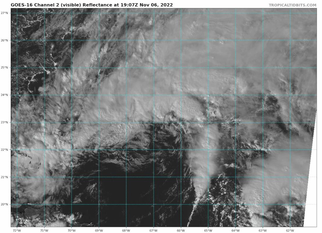
GCANE wrote:Swirl is kicking up some high-vorticity convection now.
Where would you put the COC?
0 likes
Hurricane Eye Experience: David 79, Irene 99, Frances 04, Jeanne 04, Wilma 05… Hurricane Brush Experience: Andrew 92, Erin 95, Floyd 99, Matthew 16, Irma 17, Ian 22, Nicole 22…

Re: ATL: INVEST 98L - Discussion
How far north this goes before diving south is going to be crucial as is how far it dives south. If it goes far enough north before diving south it may miss Florida completely. Further south than forecasted and Miami and even the Keys could get a direct hit. Right now of course the models have narrowed the most likely landfall between Palm Beach and Daytona.
Also an important note is this will likely not start acquiring tropical conditions until it starts to dive south.
How big of a dive south also plays a major factor in the potential strength. Worst case this will be over the gulf stream while in a favorable environment for strengthening.
Best case, this never goes fully tropical and the east coast of Florida will see gale force winds(as well as much of the US east coast) with much less rain.
It also appears this will not take on tropical features until it starts diving south.
While the widespread gale force winds and high surf for the east coast is easy forecast..when, where and if thus becomes fully tropical not so much.
While unlikely, if this does find a "bubble" of favorable conditions kind of like the GFS shows, this could be a major hurricane. On the flip side and much more likely will never be fully tropical and the top winds will likely be high end gale, low end storm force.
4 likes
-
tropicwatch

- Category 5
- Posts: 3426
- Age: 62
- Joined: Sat Jun 02, 2007 10:01 am
- Location: The Villages, Florida
- Contact:
Re: ATL: INVEST 98L - Discussion
Blown Away wrote:GCANE wrote:Swirl is kicking up some high-vorticity convection now.
[url]https://i.postimg.cc/mDrwZCfZ/goes16-vis-98-L-202211061907.gif [/url]
Where would you put the COC?
Somewhere in between buoy 41046 Location: 23.822N 68.384W Winds out of the northeast
and
Buoy 41043 Location: 21.026N 64.793W Winds out of the south-southwest.
1 likes
Tropicwatch
Agnes 72', Eloise 75, Elena 85', Kate 85', Charley 86', Florence 88', Beryl 94', Dean 95', Erin 95', Opal 95', Earl 98', Georges 98', Ivan 2004', Arlene 2005', Dennis 2005', Ida 2009' Debby 2012' Irma 2017' Michael 2018'
Agnes 72', Eloise 75, Elena 85', Kate 85', Charley 86', Florence 88', Beryl 94', Dean 95', Erin 95', Opal 95', Earl 98', Georges 98', Ivan 2004', Arlene 2005', Dennis 2005', Ida 2009' Debby 2012' Irma 2017' Michael 2018'
Re: ATL: INVEST 98L - Discussion
Jr0d wrote:How far north this goes before diving south is going to be crucial as is how far it dives south. If it goes far enough north before diving south it may miss Florida completely. Further south than forecasted and Miami and even the Keys could get a direct hit. Right now of course the models have narrowed the most likely landfall between Palm Beach and Daytona.
Also an important note is this will likely not start acquiring tropical conditions until it starts to dive south.
How big of a dive south also plays a major factor in the potential strength. Worst case this will be over the gulf stream while in a favorable environment for strengthening.
Best case, this never goes fully tropical and the east coast of Florida will see gale force winds(as well as much of the US east coast) with much less rain.
It also appears this will not take on tropical features until it starts diving south.
While the widespread gale force winds and high surf for the east coast is easy forecast..when, where and if thus becomes fully tropical not so much.
While unlikely, if this does find a "bubble" of favorable conditions kind of like the GFS shows, this could be a major hurricane. On the flip side and much more likely will never be fully tropical and the top winds will likely be high end gale, low end storm force.
The other consideration is that it’s a very large system and will create impacts far from its center, be it tropical or subtropical.
1 likes
Cleo - 1964, Betsy - 1965, David - 1979, Andrew - 1992, Charlie (Francis, Ivan, Jeanne) - 2004, Irma - 2017, Ian - 2022, Milton - 2024


-
cycloneye
- Admin
- Posts: 149520
- Age: 69
- Joined: Thu Oct 10, 2002 10:54 am
- Location: San Juan, Puerto Rico
Re: ATL: INVEST 98L - Discussion
1 likes
Visit the Caribbean-Central America Weather Thread where you can find at first post web cams,radars
and observations from Caribbean basin members Click Here
and observations from Caribbean basin members Click Here
Re: ATL: INVEST 98L - Discussion
Blown Away wrote:GCANE wrote:Swirl is kicking up some high-vorticity convection now.
[url]https://i.postimg.cc/mDrwZCfZ/goes16-vis-98-L-202211061907.gif [/url]
Where would you put the COC?
Now, somewhere under the clouds.
0 likes
Who is online
Users browsing this forum: No registered users and 14 guests