
Texas Winter 2022-2023
Moderator: S2k Moderators
Forum rules
 The posts in this forum are NOT official forecast and should not be used as such. They are just the opinion of the poster and may or may not be backed by sound meteorological data. They are NOT endorsed by any professional institution or STORM2K.

The posts in this forum are NOT official forecast and should not be used as such. They are just the opinion of the poster and may or may not be backed by sound meteorological data. They are NOT endorsed by any professional institution or STORM2K.
-
orangeblood
- S2K Supporter

- Posts: 3895
- Joined: Tue Dec 15, 2009 6:14 pm
- Location: Fort Worth, TX
Re: Texas Winter 2022-2023
First signs of a PV split showing up on long range GFS for mid month
4 likes
-
Iceresistance

- Category 5

- Posts: 9566
- Age: 22
- Joined: Sat Oct 10, 2020 9:45 am
- Location: Tecumseh, OK/Norman, OK
Re: Texas Winter 2022-2023
Portastorm wrote:Ntxw wrote:Cedar Fever. It is coming ugh...warm air from the south will make it miserable for those who suffer in NTX, like myself.
Yeah numbers going up here too. While the weather this weekend will be nice (sunny and 70s), with that pattern and south winds ... I expect cedar counts to rapidly increase. Ugh.
It’s already bad in Springfield, MO, I can only imagine how bad it is at my house.
0 likes
Bill 2015 & Beta 2020
Winter 2020-2021
All observations are in Tecumseh, OK unless otherwise noted.
Winter posts are focused mainly for Oklahoma & Texas.
Take any of my forecasts with a grain of salt, refer to the NWS, SPC, and NHC for official information
Never say Never with weather! Because ANYTHING is possible!
Winter 2020-2021
All observations are in Tecumseh, OK unless otherwise noted.
Winter posts are focused mainly for Oklahoma & Texas.
Take any of my forecasts with a grain of salt, refer to the NWS, SPC, and NHC for official information
Never say Never with weather! Because ANYTHING is possible!
-
bubba hotep

- S2K Supporter
- Posts: 6012
- Joined: Wed Dec 28, 2016 1:00 am
- Location: Collin County Texas
Re: Texas Winter 2022-2023
orangeblood wrote:First signs of a PV split showing up on long range GFS for mid month
https://images.weatherbell.com/model/gfs-deterministic/nhemi/t10_anom/1672293600/1673676000-t5As24GsZSQ.png
We'll need something to shake up the pattern. North America will be flooded with Pacific air until the NPAC jet relaxes. The Euro weeklies are particularly ugly, with the AO/NAO/EPO all going positive after mid-month, but the PNA does pull back, allowing for storms to track over Texas. That should give us some better rain chances statewide.
1 likes
Winter time post are almost exclusively focused on the DFW area.
-
CaptinCrunch

- S2K Supporter
- Posts: 8776
- Age: 57
- Joined: Mon Nov 03, 2003 4:33 pm
- Location: Kennedale, TX (Tarrant Co.)
Re: Texas Winter 2022-2023
Sorry, but I had to do it....I had to turn the damn AC back on to start the new year. 
Humidity and pollen make it no bueno for having windows open..
Humidity and pollen make it no bueno for having windows open..
3 likes


Re: Texas Winter 2022-2023
DFW's forecast of 75F on New Years day is good enough to be #5 warmest high. Low of 54 is good for top 10.
2 likes
The above post and any post by Ntxw is NOT an official forecast and should not be used as such. It is just the opinion of the poster and may or may not be backed by sound meteorological data. It is NOT endorsed by any professional institution including Storm2k. For official information, please refer to NWS products.
Help support Storm2K!

Re: Texas Winter 2022-2023
Ntxw wrote:DFW's forecast of 75F on New Years day is good enough to be #5 warmest high. Low of 54 is good for top 10.
It’s a lot easier lately to set new highs than it is to set new lows.
2 likes
-
Iceresistance
- Category 5
- Posts: 9566
- Age: 22
- Joined: Sat Oct 10, 2020 9:45 am
- Location: Tecumseh, OK/Norman, OK
Re: Texas Winter 2022-2023
The SSW over Alaska could be a monstrous one. GFS is starting to show consistency for this in Mid January
2 likes
Bill 2015 & Beta 2020
Winter 2020-2021
All observations are in Tecumseh, OK unless otherwise noted.
Winter posts are focused mainly for Oklahoma & Texas.
Take any of my forecasts with a grain of salt, refer to the NWS, SPC, and NHC for official information
Never say Never with weather! Because ANYTHING is possible!
Winter 2020-2021
All observations are in Tecumseh, OK unless otherwise noted.
Winter posts are focused mainly for Oklahoma & Texas.
Take any of my forecasts with a grain of salt, refer to the NWS, SPC, and NHC for official information
Never say Never with weather! Because ANYTHING is possible!


Re: Texas Winter 2022-2023
I don’t want anymore rain until there’s some grass to hold the mud in place.
1 likes

Re: Texas Winter 2022-2023
Brent wrote:We hit 70 after being 1 degree last Thursday
What a contrast today was compared to one week ago. Next Tues/Weds a fairly potent system with cold front should bring things back closer to normal for Oklahoma and NTX.
1 likes
The above post and any post by Ntxw is NOT an official forecast and should not be used as such. It is just the opinion of the poster and may or may not be backed by sound meteorological data. It is NOT endorsed by any professional institution including Storm2k. For official information, please refer to NWS products.
Help support Storm2K!
Help support Storm2K!
Re: Texas Winter 2022-2023
Most aggressive model run yet (GFS) for middle of next week for some relief. It is January Afterall and doesn't take much to cool it down.

5 likes
The above post and any post by Ntxw is NOT an official forecast and should not be used as such. It is just the opinion of the poster and may or may not be backed by sound meteorological data. It is NOT endorsed by any professional institution including Storm2k. For official information, please refer to NWS products.
Help support Storm2K!
Help support Storm2K!
-
Edwards Limestone

- S2K Supporter
- Posts: 504
- Age: 36
- Joined: Tue Dec 28, 2021 11:05 am
- Location: Smithson Valley, TX
Re: Texas Winter 2022-2023
Ntxw wrote:Most aggressive model run yet (GFS) for middle of next week for some relief. It is January Afterall and doesn't take much to cool it down.
https://i.imgur.com/4V6C3aK.gif
Sounds great to me! Any potential moisture falling from the sky or dry passage?
0 likes
The above post is NOT an official forecast and should not be used as such. It is just the opinion of the poster and may or may not be backed by sound meteorological data. It is NOT endorsed by any professional institution including Storm2k. For official information, please refer to NWS products.
-
cheezyWXguy

- Category 5
- Posts: 6280
- Joined: Mon Feb 13, 2006 12:29 am
- Location: Dallas, TX
Re: Texas Winter 2022-2023
If anyone is following the severe potential for next Monday, gonna have to watch how the discrepancies between the gfs and euro resolve. The gfs looks like a somewhat severe event pushing through north and east Texas before noon, but the euro is a lot slower and more concerning, producing open warm sector storms in most of the region. Probably won’t know much until the nam is in range, but something to keep an eye on.
0 likes
-
bubba hotep
- S2K Supporter
- Posts: 6012
- Joined: Wed Dec 28, 2016 1:00 am
- Location: Collin County Texas
Re: Texas Winter 2022-2023
Storms starting to build in coverage across East Texas, looks like a decent event for them.
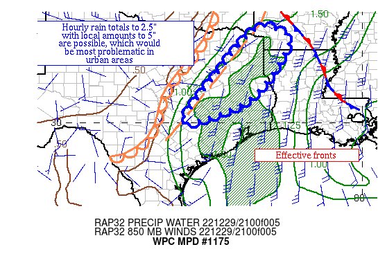
Mesoscale Precipitation Discussion 1175
NWS Weather Prediction Center College Park MD
529 PM EST Thu Dec 29 2022
Areas affected...portions of eastern TX & the ArkLaTex
Concerning...Heavy rainfall...Flash flooding possible
Valid 292229Z - 300429Z
Summary...Thunderstorms are increasing in coverage and beginning
to align across portions of eastern TX. Hourly totals to 2.5"
with local amounts of 5" are possible through 04z.
Discussion...Thunderstorms across central TX are beginning to
produce 2"+ an hour rain totals per radar estimates near Bastrop
and Giddings TX near a pre-frontal trough/leading edge of dew
point fall, with a general upward swing in coverage noted on radar
reflectivity across eastern TX. Cloud tops are cooling as well.
A second band appears to be setting up closer to Shreveport LA and
the western LA/AR border. Precipitable water values have been
rising quickly, and are up to ~1.3" near this activity per GPS
data. When combined with 1000-500 hPa thickness values near 561
dm, the atmosphere is almost completely saturated. Inflow at 850
hPa is out of the south-southwest at ~25 kts per VAD wind
profiles. Effective bulk shear is ~40 kts, which when combined
with the deep layer south-southwest flow is organizing convection
into a lengthening band. ML CAPE is 1000-1500 J/kg per SPC
mesoanalyses, with some uptick noted over the past several hours.
Upper level divergence is being aided both by an upper level
trough moving through the central Plains and an apparent shortwave
moving towards the region from northeast Mexico.
Mesoscale guidance indicates that hourly and overall rain totals
should be broadening across eastern TX into the ArkLaTex due to
this band. In a few hours, it is possible that outflow boundaries
could lead to some eastward drift, which appears to be indicated
in the 18z HREF guidance. An earlier band across west-central LA
produced local amounts of 5" -- so no reason why isolated spots in
eastern TX couldn't receive the same. Hourly totals to 2.5" are
possible where cells train, merge, and/or mesocyclones manage to
form to hold up any forward propagation in a few hours. These
totals would be most problematic in urban areas.
Roth
ATTN...WFO...EWX...FWD...HGX...SHV...
ATTN...RFC...ABRFC...LMRFC...WGRFC...NWC...
1 likes
Winter time post are almost exclusively focused on the DFW area.
Re: Texas Winter 2022-2023
Well I don’t think Cali is gonna be in a drought anymore. Never seen so much rain forecasted for that area. Pacific jet is just raging out of control.
3 likes
-
Edwards Limestone
- S2K Supporter
- Posts: 504
- Age: 36
- Joined: Tue Dec 28, 2021 11:05 am
- Location: Smithson Valley, TX
Re: Texas Winter 2022-2023
I'm sure it's been discussed here ad nauseum so forgive me, but are there any decent analogs for our winters (and spring?) in a 3rd year Nina seemingly transitioning to ENSO neutral soon?
0 likes
The above post is NOT an official forecast and should not be used as such. It is just the opinion of the poster and may or may not be backed by sound meteorological data. It is NOT endorsed by any professional institution including Storm2k. For official information, please refer to NWS products.
Re: Texas Winter 2022-2023
Edwards Limestone wrote:I'm sure it's been discussed here ad nauseum so forgive me, but are there any decent analogs for our winters (and spring?) in a 3rd year Nina seemingly transitioning to ENSO neutral soon?
The PDO is the more telling story. We are amidst a very deep -PDO episode (reverse of 2014-2019 ++PDO). The next El Nino will be of the cold PDO kind like the late 1977, 1978, 2002, and 2009 variety.
2 likes
The above post and any post by Ntxw is NOT an official forecast and should not be used as such. It is just the opinion of the poster and may or may not be backed by sound meteorological data. It is NOT endorsed by any professional institution including Storm2k. For official information, please refer to NWS products.
Help support Storm2K!
Help support Storm2K!
-
Edwards Limestone
- S2K Supporter
- Posts: 504
- Age: 36
- Joined: Tue Dec 28, 2021 11:05 am
- Location: Smithson Valley, TX
Re: Texas Winter 2022-2023
Ntxw wrote:Edwards Limestone wrote:I'm sure it's been discussed here ad nauseum so forgive me, but are there any decent analogs for our winters (and spring?) in a 3rd year Nina seemingly transitioning to ENSO neutral soon?
The PDO is the more telling story. We are amidst a very deep -PDO episode (reverse of 2014-2019 ++PDO). The next El Nino will be of the cold PDO kind like the late 1977, 1978, 2002, and 2009 variety.
Sounds like next fall/winter could be wet for Texas if true to 2009 analog. But pretty average precip until then. Dry 2023 summer? Who knows.
0 likes
The above post is NOT an official forecast and should not be used as such. It is just the opinion of the poster and may or may not be backed by sound meteorological data. It is NOT endorsed by any professional institution including Storm2k. For official information, please refer to NWS products.
Re: Texas Winter 2022-2023
18z GFS wasn’t too bad of a run. Slowly coming around to some cooler air possibly and relaxing the Pacific jet.
3 likes
-
Brent
- S2K Supporter
- Posts: 38704
- Age: 37
- Joined: Sun May 16, 2004 10:30 pm
- Location: Tulsa Oklahoma
- Contact:
Re: Texas Winter 2022-2023
One thing I noticed about today... We were 1 degree off the record high from 1984... Well January 1985 would follow
1 likes
#neversummer
Who is online
Users browsing this forum: No registered users and 142 guests