Texas Spring 2023
Moderator: S2k Moderators
Forum rules

The posts in this forum are NOT official forecast and should not be used as such. They are just the opinion of the poster and may or may not be backed by sound meteorological data. They are NOT endorsed by any professional institution or STORM2K.

Re: Texas Spring 2023
After today it looks like rain chances in southeast Texas and the eastern half of the state will be next to nothing for the most part. Looks like a dry second half of May for a lot of us.
1 likes
-
Edwards Limestone

- S2K Supporter

- Posts: 510
- Age: 36
- Joined: Tue Dec 28, 2021 11:05 am
- Location: Smithson Valley, TX
Re: Texas Spring 2023
2 likes
The above post is NOT an official forecast and should not be used as such. It is just the opinion of the poster and may or may not be backed by sound meteorological data. It is NOT endorsed by any professional institution including Storm2k. For official information, please refer to NWS products.
-
Edwards Limestone
- S2K Supporter
- Posts: 510
- Age: 36
- Joined: Tue Dec 28, 2021 11:05 am
- Location: Smithson Valley, TX
Re: Texas Spring 2023
https://www.spc.noaa.gov/products/outlook/day3otlk.html
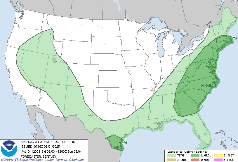
SPC AC 170728
Day 3 Convective Outlook
NWS Storm Prediction Center Norman OK
0228 AM CDT Wed May 17 2023
Valid 191200Z - 201200Z
...THERE IS A SLIGHT RISK OF SEVERE THUNDERSTORMS FROM THE CENTRAL
TEXAS VICINITY EAST-NORTHEASTWARD ACROSS ARKANSAS...
...SUMMARY...
Strong/locally severe storms are expected Friday from parts of the
southern Plains eastward across the Arkansas vicinity.
...Synopsis...
An upper trough is forecast to continue progressing southeastward
across the Great Lakes/Midwest/central Plains region Friday.
Meanwhile, persistent ridging is expected to remain over the West.
At the surface, the primary feature of interest will be a cold
front, forecast to advance southeastward across the Great Lakes,
Ohio/mid Mississippi Valleys, and southern Plains through the
period.
...Parts of Oklahoma and Texas eastward across Arkansas...
Showers and thunderstorms are forecast to be ongoing across parts of
Oklahoma and vicinity early Friday, ahead of the advancing cold
front. Meanwhile, as the moist warm-sector boundary layer across
the southern Plains and eastward toward the Lower Mississippi Valley
destabilizes through late afternoon, an increase in storms is
expected to begin, which should then continue through the evening.
Along with the amply unstable pre-frontal environment, moderately
enhanced flow through a deep layer -- around the base of the
aforementioned upper trough -- is expected to spread/reside atop the
warm sector. As such, organized/locally severe storms are expected
within the broader area of convection. Hail and locally damaging
winds appear to be the primary risks, with this potential likely to
continue through the evening and into the overnight hours as storms
spread eastward/southeastward with time.
..Goss.. 05/17/2023
1 likes
The above post is NOT an official forecast and should not be used as such. It is just the opinion of the poster and may or may not be backed by sound meteorological data. It is NOT endorsed by any professional institution including Storm2k. For official information, please refer to NWS products.
Re: Texas Spring 2023
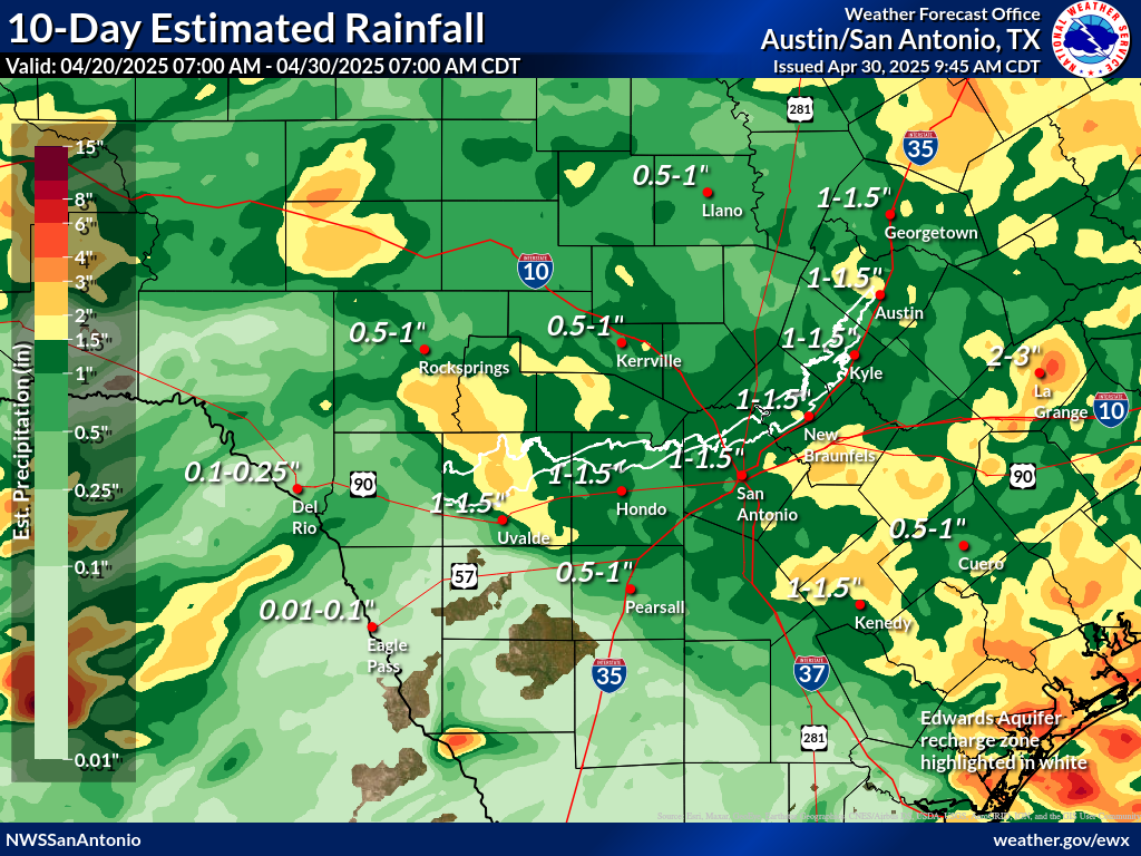
Edwards Limestone wrote:https://www.weather.gov/images/ewx/products/rainfall/rainfall10day.png
How can I find one of these for southeast TX?
0 likes
-
Edwards Limestone
- S2K Supporter
- Posts: 510
- Age: 36
- Joined: Tue Dec 28, 2021 11:05 am
- Location: Smithson Valley, TX
Re: Texas Spring 2023
Cpv17 wrote:Edwards Limestone wrote:https://www.weather.gov/images/ewx/products/rainfall/rainfall10day.png
How can I find one of these for southeast TX?
I wasn't able to find that product on the Houston NWS homepage, but these are interactive precip maps from NWS:
https://water.weather.gov/precip/
https://noaa.maps.arcgis.com/apps/MapSeries/index.html?appid=ed433140c2a24b67aa9f19d2e3ea1977
1 likes
The above post is NOT an official forecast and should not be used as such. It is just the opinion of the poster and may or may not be backed by sound meteorological data. It is NOT endorsed by any professional institution including Storm2k. For official information, please refer to NWS products.
Re: Texas Spring 2023
Informative post by Steve McCauley yesterday describing why storms could be limited Friday.
1 likes
-
txtwister78

- Category 5

- Posts: 2175
- Joined: Wed Jan 30, 2019 12:56 pm
- Location: San Antonio
Re: Texas Spring 2023
Rainfall over the past several weeks no doubt has led to significant improvement of drought conditions across a good chunk of SC TX with hopefully more on the way late Friday into early Saturday morning.
https://twitter.com/NWSSanAntonio/status/1659216997992005632
https://twitter.com/NWSSanAntonio/status/1659216997992005632
3 likes

Re: Texas Spring 2023
SW to NC/NE TX should get some storms later today. Mostly some wind/hail threat, nothing too serious. Hope those that need some rain get it.
2 likes
-
bubba hotep

- S2K Supporter
- Posts: 6014
- Joined: Wed Dec 28, 2016 1:00 am
- Location: Collin County Texas
Re: Texas Spring 2023
cstrunk wrote:SW to NC/NE TX should get some storms later today. Mostly some wind/hail threat, nothing too serious. Hope those that need some rain get it.
12z SPC HREF looks pretty good for storms this afternoon from SE OK, back SW through DFW, and down into the Hill Country. Let's go!
1 likes
Winter time post are almost exclusively focused on the DFW area.
-
bubba hotep
- S2K Supporter
- Posts: 6014
- Joined: Wed Dec 28, 2016 1:00 am
- Location: Collin County Texas
Re: Texas Spring 2023
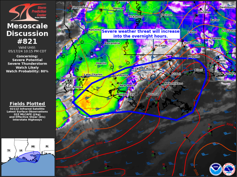
Mesoscale Discussion 0821
NWS Storm Prediction Center Norman OK
1249 PM CDT Fri May 19 2023
Areas affected...portions of southeastern Oklahoma and the ArkLaTex
Concerning...Severe potential...Severe Thunderstorm Watch likely
Valid 191749Z - 191915Z
Probability of Watch Issuance...95 percent
SUMMARY...Scattered severe storms, including supercells, are
expected to develop this afternoon in the wake of an early morning
MCS. Large hail is expected to be the primary threat, though
isolated damaging gusts and a tornado cannot be ruled out. A Severe
Thunderstorm Watch is likely this afternoon.
DISCUSSION...In the wake of an early morning MCS and remnant MCV
across eastern OK and the ArkLaTex, clearing skies have aided in
rapid recovery of the air mass early this afternoon. Strong
insolation has allowed surface temperatures to warm into the 70s F
with dewpoints remaining in the low to mid 60s F. Continued
modification of the air mass is likely through the next couple of
hours, supporting the development of 1500-2000 J/kg of MLCAPE. As
instability develops and lingering inhibition is removed, the
development of severe storms is likely across a couple of areas this
afternoon.
Aided by the remnant MCV, area VAD/VWPs show moderate effective
shear (30-40 kt) sufficient for storm organization, including
supercells. Storms may first develop ahead of the remnant MCV across
eastern OK before spreading eastward into AR. A few storms may also
develop on the trailing outflow near the Red River and possibly as
far west as central OK. Despite the poor mid-level lapse rates, the
supercell storm mode will favor large hail potential with the
stronger sustained updrafts. The lack of stronger low-level flow
lends lower confidence in the potential for damaging winds and or
tornadoes. However, given the supercell mode, a strong gusts and a
brief tornado cannot be ruled out. With the potential for strong to
severe storms to develop early this afternoon, a new Severe
Thunderstorm Watch is likely.
..Lyons/Grams.. 05/19/2023
...Please see http://www.spc.noaa.gov for graphic product...
ATTN...WFO...LZK...SHV...TSA...FWD...OUN...
0 likes
Winter time post are almost exclusively focused on the DFW area.
Re: Texas Spring 2023
Officially 90 degrees at the big airport. A humid 90 at that. Saturday and Sunday will feel refreshing after today. Hopefully we get some solid boomers before the cool front sweeps through.
1 likes
-
bubba hotep
- S2K Supporter
- Posts: 6014
- Joined: Wed Dec 28, 2016 1:00 am
- Location: Collin County Texas
Re: Texas Spring 2023
Some nice convergence along that OFB that is sagging off to the NW of DFW with storms already firing off. That cell that is moving into northern Collin County went from a puff of an updraft to svr warned with the quickness.
0 likes
Winter time post are almost exclusively focused on the DFW area.

Re: Texas Spring 2023
So frustrating to watch storms blowup JUST to your Southeast and move away from you. This seems to have happened a few times this year to us NW-plexers.
Oh well, I guess it's nice to at least hear some thunder from afar.
Oh well, I guess it's nice to at least hear some thunder from afar.
1 likes
-
bubba hotep
- S2K Supporter
- Posts: 6014
- Joined: Wed Dec 28, 2016 1:00 am
- Location: Collin County Texas
Re: Texas Spring 2023
I wonder if anything is going to fire when the incoming front crashes into the NW drifting out flow moving away from DFW?
0 likes
Winter time post are almost exclusively focused on the DFW area.
-
rwfromkansas
- Category 5
- Posts: 3032
- Joined: Sat Aug 27, 2005 12:47 am
- Location: North Fort Worth
-
bubba hotep
- S2K Supporter
- Posts: 6014
- Joined: Wed Dec 28, 2016 1:00 am
- Location: Collin County Texas
Re: Texas Spring 2023
Looks like there was some localized nasty hail over parts of Plano with that last cell.
0 likes
Winter time post are almost exclusively focused on the DFW area.
-
bubba hotep
- S2K Supporter
- Posts: 6014
- Joined: Wed Dec 28, 2016 1:00 am
- Location: Collin County Texas
Re: Texas Spring 2023
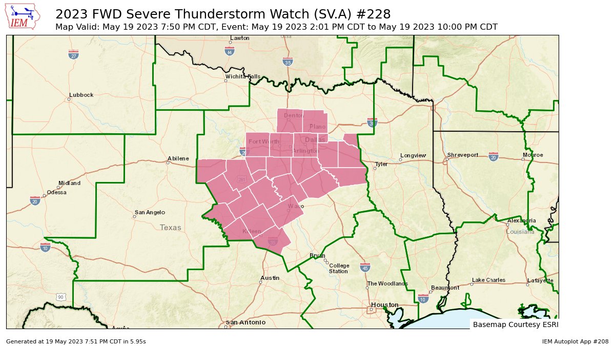
Watch Extended until 10:00 pm for DFW
0 likes
Winter time post are almost exclusively focused on the DFW area.
-
Iceresistance

- Category 5
- Posts: 9581
- Age: 22
- Joined: Sat Oct 10, 2020 9:45 am
- Location: Tecumseh, OK/Norman, OK
Re: Texas Spring 2023
Next week could be problematic.
1 likes
Bill 2015 & Beta 2020
Winter 2020-2021
All observations are in Tecumseh, OK unless otherwise noted.
Winter posts are focused mainly for Oklahoma & Texas.
Take any of my forecasts with a grain of salt, refer to the NWS, SPC, and NHC for official information
Never say Never with weather! Because ANYTHING is possible!
Winter 2020-2021
All observations are in Tecumseh, OK unless otherwise noted.
Winter posts are focused mainly for Oklahoma & Texas.
Take any of my forecasts with a grain of salt, refer to the NWS, SPC, and NHC for official information
Never say Never with weather! Because ANYTHING is possible!
-
bubba hotep
- S2K Supporter
- Posts: 6014
- Joined: Wed Dec 28, 2016 1:00 am
- Location: Collin County Texas
Re: Texas Spring 2023
Iceresistance wrote:Next week could be problematic.
For who? Definitely not my area. Southeast Texas looks like a huge snooze fest for the next 2-3 weeks.
1 likes
Return to “USA & Caribbean Weather”
Who is online
Users browsing this forum: AnnularCane and 46 guests