ATL: HAROLD - Remnants - Discussion
Moderator: S2k Moderators

Re: ATL: INVEST 91L - Discussion
Pretty broad envelope! Might just be a decent surge of precip for much of the Texas coastline
0 likes
Andy D
(For official information, please refer to the NHC and NWS products.)
(For official information, please refer to the NHC and NWS products.)
-
Ivanhater

- Storm2k Moderator

- Posts: 11222
- Age: 39
- Joined: Fri Jul 01, 2005 8:25 am
- Location: Pensacola
Re: ATL: INVEST 91L - Discussion
Imo, this will very likely become Gert before landfall. Models are playing catch-up.I would venture to say a strong TS with an outside shot at a hurricane.
0 likes
Michael
-
REDHurricane

- Category 1

- Posts: 438
- Age: 28
- Joined: Sun Jul 03, 2022 2:36 pm
- Location: Northeast Pacific Ocean
Re: ATL: INVEST 91L - Discussion
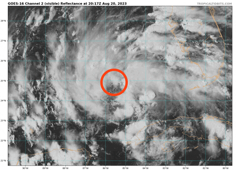
Looks like the LLC is currently forming near 25ºN, 86ºW -- probably still needs to build more convection around the center and get itself better stacked vertically for the NHC to consider upgrading
0 likes
Re: ATL: INVEST 91L - Discussion
Should be Gert by tomorrow organizing a bit quicker than models have shown to no one's surprise. I'm thinking a 60-65 mph TS into South Texas/North East Mexico with an outside chance of becoming a weak cat 1.
0 likes
-
tolakram
- Admin

- Posts: 20186
- Age: 62
- Joined: Sun Aug 27, 2006 8:23 pm
- Location: Florence, KY (name is Mark)
Re: ATL: INVEST 91L - Discussion


0 likes
M a r k
- - - - -
Join us in chat: Storm2K Chatroom Invite. Android and IOS apps also available.
The posts in this forum are NOT official forecasts and should not be used as such. Posts are NOT endorsed by any professional institution or STORM2K.org. For official information and forecasts, please refer to NHC and NWS products.
-
tolakram
- Admin
- Posts: 20186
- Age: 62
- Joined: Sun Aug 27, 2006 8:23 pm
- Location: Florence, KY (name is Mark)
Re: ATL: INVEST 91L - Discussion
Hillary falling apart faster could mean improved conditions in the western gulf. The 18Z GFS seems to see a last minute ramp up just before landfall.
0 likes
M a r k
- - - - -
Join us in chat: Storm2K Chatroom Invite. Android and IOS apps also available.
The posts in this forum are NOT official forecasts and should not be used as such. Posts are NOT endorsed by any professional institution or STORM2K.org. For official information and forecasts, please refer to NHC and NWS products.
- - - - -
Join us in chat: Storm2K Chatroom Invite. Android and IOS apps also available.
The posts in this forum are NOT official forecasts and should not be used as such. Posts are NOT endorsed by any professional institution or STORM2K.org. For official information and forecasts, please refer to NHC and NWS products.
-
jaguars_22
- Category 2

- Posts: 629
- Joined: Tue Jun 20, 2017 2:26 pm
- Location: Victoria TX
Re: ATL: INVEST 91L - Discussion
Could this thing continue wnw and come in further north? Stronger system… could it bump the ridge more?
0 likes
Re: ATL: INVEST 91L - Discussion
jaguars_22 wrote:Could this thing continue wnw and come in further north? Stronger system… could it bump the ridge more?
I doubt it this ridge is no joke and it will struggle to gain latitude.
1 likes
-
tolakram
- Admin
- Posts: 20186
- Age: 62
- Joined: Sun Aug 27, 2006 8:23 pm
- Location: Florence, KY (name is Mark)
Re: ATL: INVEST 91L - Discussion
jaguars_22 wrote:Could this thing continue wnw and come in further north? Stronger system… could it bump the ridge more?
No way (well, I'm not sure how much further north, but not much IMO), one of the strongest ridges in a long long time, and I don't see it ending any time soon. Even up here we're expecting 90's to near 100 this week, and we've escaped most of the heat so far this year.
0 likes
M a r k
- - - - -
Join us in chat: Storm2K Chatroom Invite. Android and IOS apps also available.
The posts in this forum are NOT official forecasts and should not be used as such. Posts are NOT endorsed by any professional institution or STORM2K.org. For official information and forecasts, please refer to NHC and NWS products.
- - - - -
Join us in chat: Storm2K Chatroom Invite. Android and IOS apps also available.
The posts in this forum are NOT official forecasts and should not be used as such. Posts are NOT endorsed by any professional institution or STORM2K.org. For official information and forecasts, please refer to NHC and NWS products.
-
jaguars_22
- Category 2
- Posts: 629
- Joined: Tue Jun 20, 2017 2:26 pm
- Location: Victoria TX
Re: ATL: INVEST 91L - Discussion
I was hoping Corpus Christi so the rain will hit us in like Victoria, houston
0 likes
-
wxman57

- Moderator-Pro Met

- Posts: 23175
- Age: 68
- Joined: Sat Jun 21, 2003 8:06 pm
- Location: Houston, TX (southwest)
Re: ATL: INVEST 91L - Discussion
jaguars_22 wrote:I was hoping Corpus Christi so the rain will hit us in like Victoria, houston
It would have to move ashore closer to Freeport for Houston to get any significant rain. Victoria could get around an inch out of the system.
0 likes
-
Stratton23
- Category 5

- Posts: 3577
- Joined: Fri Jul 21, 2023 10:59 pm
- Location: Katy, Tx
Re: ATL: INVEST 91L - Discussion
 Yeah this is a big nothing burger for SE Texas, but The gulf of mexico will be open for business next week as well, increasing odds of a pacific crossover into the BOC or Western Caribbean are going up ( ensemble support is their, from all three models) also our heat ridge will be weakening and backing off to our west, so this system will probably not be the last one to track in the gulf
0 likes
-
Hurricane Mike
- Category 2
- Posts: 675
- Joined: Tue Apr 10, 2018 7:44 am
Re: ATL: INVEST 91L - Discussion
Looks similar to Erika 2003 or Hanna 2020. Don't rule out hurricane status before landfall.
1 likes
Re: ATL: INVEST 91L - Discussion
Shouldn't this be a PTC? It will be impacting South Texas/NE Mexico in about 36 hours.
0 likes
-
gatorcane

- S2K Supporter

- Posts: 23708
- Age: 48
- Joined: Sun Mar 13, 2005 3:54 pm
- Location: Boca Raton, FL
Re: ATL: INVEST 91L - Discussion
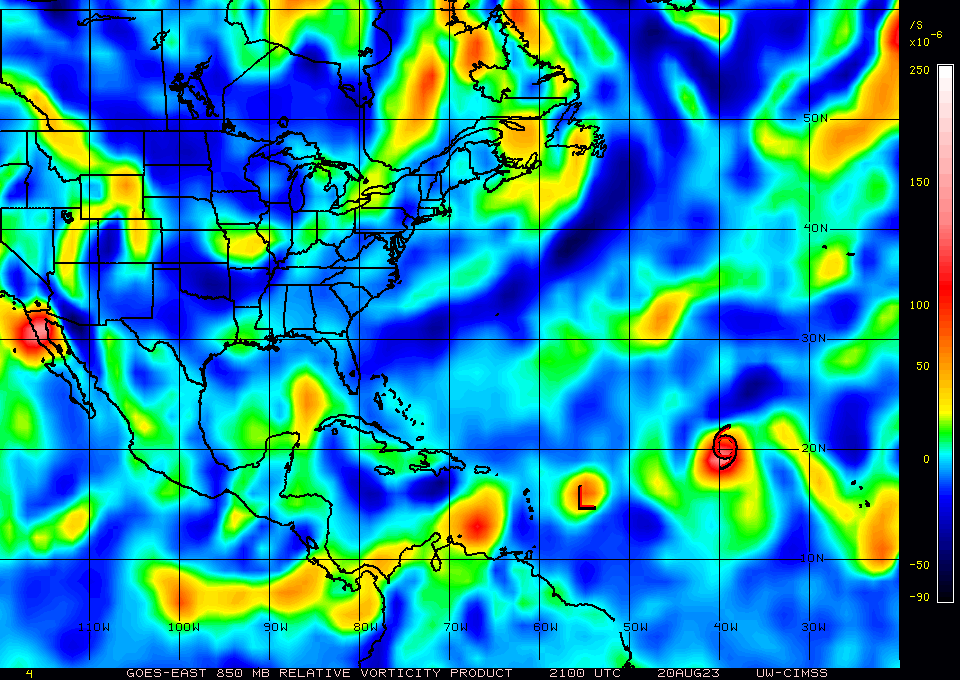
Convection is decreasing with the diurnal minimum but the 850mb vorticity has tightened some over the last 6 to 9 hours:
Plus the GFS model shows a TS now just before landfall. Expecting code red for the 8pm NHC outlook.
Plus the GFS model shows a TS now just before landfall. Expecting code red for the 8pm NHC outlook.
0 likes
-
tropicwatch

- Category 5
- Posts: 3427
- Age: 62
- Joined: Sat Jun 02, 2007 10:01 am
- Location: The Villages, Florida
- Contact:
Re: ATL: INVEST 91L - Discussion
Currently encountering 25 to 30kt wind shear.
0 likes
Tropicwatch
Agnes 72', Eloise 75, Elena 85', Kate 85', Charley 86', Florence 88', Beryl 94', Dean 95', Erin 95', Opal 95', Earl 98', Georges 98', Ivan 2004', Arlene 2005', Dennis 2005', Ida 2009' Debby 2012' Irma 2017' Michael 2018'
Agnes 72', Eloise 75, Elena 85', Kate 85', Charley 86', Florence 88', Beryl 94', Dean 95', Erin 95', Opal 95', Earl 98', Georges 98', Ivan 2004', Arlene 2005', Dennis 2005', Ida 2009' Debby 2012' Irma 2017' Michael 2018'
-
galvestontx
- Tropical Depression

- Posts: 57
- Joined: Wed Sep 21, 2005 1:00 pm
- Location: houston texas
- Contact:
Re: ATL: INVEST 91L - Discussion
Well heading to Port Aransas tomorrow morning for a week vacation, will see how it goes lol.
1 likes
-
cycloneye

- Admin
- Posts: 149730
- Age: 69
- Joined: Thu Oct 10, 2002 10:54 am
- Location: San Juan, Puerto Rico
Re: ATL: INVEST 91L - Discussion
Code Red

Western Gulf of Mexico (AL91):
Showers and thunderstorms have increased this evening, and are
becoming better organized in association with a trough of low
pressure located in the eastern Gulf of Mexico. Environmental
conditions appear favorable for development of this system as it
moves westward at about 15 to 20 mph across the central Gulf of
Mexico. A tropical depression or storm is likely to form as it
approaches the western Gulf of Mexico coastline by Tuesday.
Interests in the western Gulf of Mexico should monitor the progress
of this system. Tropical storm watches or warnings may be necessary
on Monday for portions of the southern Texas and northern Mexico
coastlines.
* Formation chance through 48 hours...high...70 percent.
* Formation chance through 7 days...high...70 percent.
0 likes
Visit the Caribbean-Central America Weather Thread where you can find at first post web cams,radars
and observations from Caribbean basin members Click Here
and observations from Caribbean basin members Click Here
-
Sciencerocks
- Category 5
- Posts: 10193
- Age: 40
- Joined: Thu Jul 06, 2017 1:51 am

Re: ATL: INVEST 91L - Discussion
tropicwatch wrote:Currently encountering 25 to 30kt wind shear.
No, wind shear should be around 10kt.
0 likes
Who is online
Users browsing this forum: No registered users and 67 guests