https://twitter.com/ChrisJacksonSC/status/1695460061819126061
ATL: IDALIA - Post-Tropical - Discussion
Moderator: S2k Moderators
-
cycloneye

- Admin

- Posts: 149717
- Age: 69
- Joined: Thu Oct 10, 2002 10:54 am
- Location: San Juan, Puerto Rico
Re: ATL: INVEST 93L - Discussion
0 likes
Visit the Caribbean-Central America Weather Thread where you can find at first post web cams,radars
and observations from Caribbean basin members Click Here
and observations from Caribbean basin members Click Here
-
Poonwalker
- Category 1

- Posts: 270
- Joined: Tue Sep 20, 2022 11:12 am
Re: ATL: INVEST 93L - Discussion
It’s going to be affected by westerly shear and have a tilted presentation. At least for a couple days. Doing a good job though organizing so far.
0 likes
-
gatorcane

- S2K Supporter

- Posts: 23708
- Age: 48
- Joined: Sun Mar 13, 2005 3:54 pm
- Location: Boca Raton, FL
Re: ATL: INVEST 93L - Discussion
Agreed coming together quickly and models might have to play catch-up. There even looks to be banding on the SE side forming.
What does a stronger storm in the short-term mean for track implications?
What does a stronger storm in the short-term mean for track implications?
Last edited by gatorcane on Sat Aug 26, 2023 10:42 am, edited 1 time in total.
1 likes
-
cycloneye
- Admin
- Posts: 149717
- Age: 69
- Joined: Thu Oct 10, 2002 10:54 am
- Location: San Juan, Puerto Rico
Re: ATL: INVEST 93L - Discussion
0 likes
Visit the Caribbean-Central America Weather Thread where you can find at first post web cams,radars
and observations from Caribbean basin members Click Here
and observations from Caribbean basin members Click Here
-
MississippiWx

- S2K Supporter
- Posts: 1720
- Joined: Sat Aug 14, 2010 1:44 pm
- Location: Hattiesburg, Mississippi
Re: ATL: INVEST 93L - Discussion
cycloneye wrote:Impressive radar presentation.
https://twitter.com/TheSteveCop/status/1695459295498743984
Not hard at all to tell if the circulation is closed. Everything from surface observations to satellite shows it’s closed.
2 likes
This post is not an official forecast and should not be used as such. It is just the opinion of MississippiWx and may or may not be backed by sound meteorological data. It is not endorsed by any professional institution including storm2k.org. For Official Information please refer to the NHC and NWS products.


Re: ATL: INVEST 93L - Discussion
Does not appear at least from Sat views that the center is over the eastern tip of the Yucatan as shown by a map earlier on.
0 likes

Re: ATL: INVEST 93L - Discussion
MetroMike wrote:Does not appear at least from Sat views that the center is over the eastern tip of the Yucatan as shown by a map earlier on.
Looking at the radar from the previous post, it still looks like it is over water still and may stay there.
0 likes

Re: ATL: INVEST 93L - Discussion
ASSUMING continued organization throughout the day and if we begin to see improved banding, then I would guess the 2:00pm TWO will heighten the message that a TD may be forming, and mention recon to investigate the disturbance later this eve.
I think that the earliest that any upgrade would occur might be an 8:00pm or 9:00pm Special Advisory following data from recon. Thereafter, PTS or Storm Watches perhaps commensing early tomorrow.
I think that the earliest that any upgrade would occur might be an 8:00pm or 9:00pm Special Advisory following data from recon. Thereafter, PTS or Storm Watches perhaps commensing early tomorrow.
2 likes
Andy D
(For official information, please refer to the NHC and NWS products.)
(For official information, please refer to the NHC and NWS products.)
Re: ATL: INVEST 93L - Discussion
gatorcane wrote:What does a stronger storm in the short-term mean for track implications?
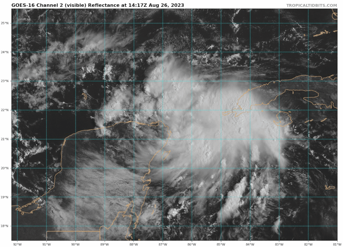
https://i.postimg.cc/xCJhQNRM/goes16-vis-93-L-202308261417.gif
Usually more N.
0 likes
-
ScottNAtlanta

- Category 5

- Posts: 2535
- Joined: Sat May 25, 2013 3:11 pm
- Location: Atlanta, GA
Re: ATL: INVEST 93L - Discussion
Was just reading the discussion from the local MET office here in Atlanta, and in their long term forecast which begins Monday they say there will be 2 fronts trying to push through here. One will come Sunday but stall just south of Atlanta and one will push through on Wednesday. The second front is the one that could possibly affect 93L, but that wont happen until Wed. That will give this quite a bit of time to strengthen before any potential shear makes an appearance.
0 likes
The posts in this forum are NOT official forecast and should not be used as such. They are just the opinion of the poster and may or may not be backed by sound meteorological data. They are NOT endorsed by any professional institution or storm2k.org. For official information, please refer to the NHC and NWS products.
Re: ATL: INVEST 93L - Discussion
gatorcane wrote:Agreed coming together quickly and models might have to play catch-up. There even looks to be banding on the SE side forming.
What does a stronger storm in the short-term mean for track implications?
https://i.postimg.cc/xCJhQNRM/goes16-vis-93-L-202308261417.gif
Great question. I was wondering the same thing
1 likes
Andy D
(For official information, please refer to the NHC and NWS products.)
(For official information, please refer to the NHC and NWS products.)

Re: ATL: INVEST 93L - Discussion
A stronger storm is higher winds over the Loop Current which pulls more heat out of the water.
A positive feedback mechanism for strengthening.
Very notable canes went down this path. We all know their names.
A positive feedback mechanism for strengthening.
Very notable canes went down this path. We all know their names.
2 likes
-
Sciencerocks
- Category 5
- Posts: 10193
- Age: 40
- Joined: Thu Jul 06, 2017 1:51 am

-
cycloneye
- Admin
- Posts: 149717
- Age: 69
- Joined: Thu Oct 10, 2002 10:54 am
- Location: San Juan, Puerto Rico
Re: ATL: INVEST 93L - Discussion
I think they may issued a Special Tropical Weather Outlook before 2 PM at this rate.
4 likes
Visit the Caribbean-Central America Weather Thread where you can find at first post web cams,radars
and observations from Caribbean basin members Click Here
and observations from Caribbean basin members Click Here
Re: ATL: INVEST 93L - Discussion
ScottNAtlanta wrote:Was just reading the discussion from the local MET office here in Atlanta, and in their long term forecast which begins Monday they say there will be 2 fronts trying to push through here. One will come Sunday but stall just south of Atlanta and one will push through on Wednesday. The second front is the one that could possibly affect 93L, but that wont happen until Wed. That will give this quite a bit of time to strengthen before any potential shear makes an appearance.
That second front may also imply an increased eastward nudge in storm track as we approach that point in the track cycle
0 likes
Andy D
(For official information, please refer to the NHC and NWS products.)
(For official information, please refer to the NHC and NWS products.)
Re: ATL: INVEST 93L - Discussion
cycloneye wrote:I think they may issued a Special Tropical Weather Outlook before 2 PM at this rate.
The way this has evolved, i'll be a long 12 hour satellite loop will be impressive to look at
0 likes
Andy D
(For official information, please refer to the NHC and NWS products.)
(For official information, please refer to the NHC and NWS products.)
-
Stormlover1970
- Tropical Low

- Posts: 32
- Age: 56
- Joined: Sun May 22, 2022 9:26 am
- Location: New Port Richey, Florida
Re: ATL: INVEST 93L - Discussion Update= Tropical Cyclone Formation Alert issued
A weakening MCSJavlin wrote:Something coming together @ 86.5ishW/ 21.5N??
https://www.tropicaltidbits.com/sat/sat ... roduct=vis
What just came out of the Big bend area this morning pushing far into the GOM?
https://www.tropicaltidbits.com/sat/sat ... =truecolor
1 likes
-
toad strangler

- S2K Supporter
- Posts: 4546
- Joined: Sun Jul 28, 2013 3:09 pm
- Location: Earth
- Contact:
Re: ATL: INVEST 93L - Discussion
Peak season magic
1 likes
My Weather Station
https://www.wunderground.com/dashboard/pws/KFLPORTS603
https://www.wunderground.com/dashboard/pws/KFLPORTS603
Re: ATL: INVEST 93L - Discussion
MississippiWx wrote:cycloneye wrote:Impressive radar presentation.
https://twitter.com/TheSteveCop/status/1695459295498743984
Not hard at all to tell if the circulation is closed. Everything from surface observations to satellite shows it’s closed.
No doubt there's tons of low level west winds feeding in. Only thing i question is how tight or broad is the LLC, max sustained winds, and how closely co-located with an obviously vigorous MLC.
1 likes
Andy D
(For official information, please refer to the NHC and NWS products.)
(For official information, please refer to the NHC and NWS products.)
Who is online
Users browsing this forum: No registered users and 204 guests