I was reading through the Sam models thread recently given the number of social media comparisons being presented between this storm and 95L. It's certainly possible that this ends up as a similar strength/track storm compared to Sam. However, one thing to note is that Sam developed earlier (near roughly 33 W) while 95L is more west than that. Additionally, Sam experienced a dramatic slowdown, followed by a turn to the NW and eventually north, and occurred in late September, when climatology heavily favors pure recurves in general.
With that being said, every little bit of latitude that 95L does not gain during its early stages could really matter for its future later down the road. Whether it goes out to sea completely, affects the Northeast US, or grazes the Lesser Antilles, this is going to definitely be a storm to watch in the sense that the conditions that are predicted for its future make it a storm that nobody would ever want to be affected by.
ATL: LEE - Models
Moderator: S2k Moderators
-
Category5Kaiju

- Category 5

- Posts: 4326
- Joined: Thu Dec 24, 2020 12:45 pm
- Location: Seattle and Phoenix
Re: ATL: INVEST 95L - Models
2 likes
Unless explicitly stated, all info in my posts is based on my own opinions and observations. Tropical storms and hurricanes can be extremely dangerous. Refer to an accredited weather research agency or meteorologist if you need to make serious decisions regarding an approaching storm.

Re: ATL: INVEST 95L - Models
Category5Kaiju wrote:I was reading through the Sam models thread recently given the number of social media comparisons being presented between this storm and 95L. It's certainly possible that this ends up as a similar strength/track storm compared to Sam. However, one thing to note is that Sam developed earlier (near roughly 33 W) while 95L is more west than that. Additionally, Sam experienced a dramatic slowdown, followed by a turn to the NW and eventually north, and occurred in late September, when climatology heavily favors pure recurves in general.
With that being said, every little bit of latitude that 95L does not gain during its early stages could really matter for its future later down the road. Whether it goes out to sea completely, affects the Northeast US, or grazes the Lesser Antilles, this is going to definitely be a storm to watch in the sense that the conditions that are predicted for its future make it a storm that nobody would ever want to be affected by.
Agree, if I was in the islands I would be watching this short term motion. If it comes further west there is no way this does not clip or directly strike. I don't see the short term NW motion being progged. This is why I am waiting for this to form to start buying into the model runs completely.
1 likes
The following post is NOT an official forecast and should not be used as such. It is just the opinion of the poster and may or may not be backed by sound meteorological data. It is NOT endorsed by any professional institution including storm2k.org For Official Information please refer to the NHC and NWS products.
-
AubreyStorm

- Category 1

- Posts: 337
- Age: 45
- Joined: Fri Jun 16, 2017 6:21 pm
- Location: Texas, USA
Re: ATL: INVEST 95L - Models
I read this: Yizzuussss
@wolfywise3
Worth noting that #95L is currently moving west, well south of guidance.
“I doubt such a scenario is possible. This is more a concern for the Caribbean islands”

@wolfywise3
Worth noting that #95L is currently moving west, well south of guidance.
“I doubt such a scenario is possible. This is more a concern for the Caribbean islands”
6 likes
The posts are NOT an official forecast. Please REFER to the NHC and NWS for official forecasts and products.
-
Meteorcane

- Category 2

- Posts: 559
- Joined: Thu Jul 21, 2011 6:49 am
- Location: North Platte Nebraska
Re: ATL: INVEST 95L - Models
GFS continues to be insistent upon the amplified Great Lakes closed low and upstream ridge pattern in the extended... I'll give it some props for essentially doing this 4 straight runs in the day 8-9 range but definitely add odds with the EC's more progressive pattern.

0 likes
-
cheezyWXguy

- Category 5
- Posts: 6280
- Joined: Mon Feb 13, 2006 12:29 am
- Location: Dallas, TX
Re: ATL: INVEST 95L - Models
Meteorcane wrote:GFS continues to be insistent upon the amplified Great Lakes closed low and upstream ridge pattern in the extended... I'll give it some props for essentially doing this 4 straight runs in the day 8-9 range but definitely add odds with the EC's more progressive pattern.
https://i.imgur.com/uofjgCn.png
Even though it does consistently show the trough, there’s still a good degree of run to run variation in whether the trough cuts farther north or farther south. The farther south this occurs, the more dangerous it is for the NE.
Additionally, I think the gfs is shifting more north in the mid range as it catches up on the degree of expected strengthening. This seems to be key, as every bit of latitude it gains in the next days looks to influence how early it starts to get pulled north. Given that it’s already a bit south of the short term guidance, we will need to watch closely to see if this bend northward actually happens when the rate of development kicks up in the next day or two.
0 likes
Re: ATL: INVEST 95L - Models
The 12Z UKMET was the westernmost 12Z major model run by 300-350 miles. Despite that, the 0Z is ~200 miles WSW of the 12Z. It is also weaker.
So, at 168, the 0Z UKMET is a whopping 500 miles WSW of the 0Z GFS and 450 miles W of the 0Z ICON in the SE Bahamas moving slowly WNW:
NEW TROPICAL CYCLONE FORECAST TO DEVELOP AFTER 24 HOURS
FORECAST POSITION AT T+ 24 : 13.3N 41.7W
LEAD CENTRAL MAXIMUM WIND
VERIFYING TIME TIME POSITION PRESSURE (MB) SPEED (KNOTS)
-------------- ---- -------- ------------- -------------
0000UTC 06.09.2023 24 13.3N 41.7W 1010 23
1200UTC 06.09.2023 36 13.9N 44.5W 1007 31
0000UTC 07.09.2023 48 15.0N 46.5W 1007 35
1200UTC 07.09.2023 60 16.1N 48.9W 1006 34
0000UTC 08.09.2023 72 17.0N 52.0W 1006 32
1200UTC 08.09.2023 84 17.9N 55.3W 1006 35
0000UTC 09.09.2023 96 18.9N 58.6W 1006 32
1200UTC 09.09.2023 108 19.3N 62.1W 1006 38
0000UTC 10.09.2023 120 20.3N 65.1W 1005 40
1200UTC 10.09.2023 132 21.2N 67.9W 1004 41
0000UTC 11.09.2023 144 21.7N 69.4W 1005 38
1200UTC 11.09.2023 156 22.1N 71.5W 1004 36
0000UTC 12.09.2023 168 22.7N 72.9W 1004 34
2 likes
Personal Forecast Disclaimer:
The posts in this forum are NOT official forecasts and should not be used as such. They are just the opinion of the poster and may or may not be backed by sound meteorological data. They are NOT endorsed by any professional institution or storm2k.org. For official information, please refer to the NHC and NWS products.
The posts in this forum are NOT official forecasts and should not be used as such. They are just the opinion of the poster and may or may not be backed by sound meteorological data. They are NOT endorsed by any professional institution or storm2k.org. For official information, please refer to the NHC and NWS products.
-
ElectricStorm

- Category 5
- Posts: 5128
- Age: 25
- Joined: Tue Aug 13, 2019 11:23 pm
- Location: Norman, OK
Re: ATL: INVEST 95L - Models
My word HAFS-B 

5 likes
B.S Meteorology, University of Oklahoma '25
Please refer to the NHC, NWS, or SPC for official information.
Please refer to the NHC, NWS, or SPC for official information.
Re: ATL: INVEST 95L - Models
LarryWx wrote:The 12Z UKMET was the westernmost 12Z major model run by 300-350 miles. Despite that, the 0Z is ~200 miles WSW of the 12Z. It is also weaker.
So, at 168, the 0Z UKMET is a whopping 500 miles WSW of the 0Z GFS and 450 miles W of the 0Z ICON in the SE Bahamas moving slowly WNW:
NEW TROPICAL CYCLONE FORECAST TO DEVELOP AFTER 24 HOURS
FORECAST POSITION AT T+ 24 : 13.3N 41.7W
LEAD CENTRAL MAXIMUM WIND
VERIFYING TIME TIME POSITION PRESSURE (MB) SPEED (KNOTS)
-------------- ---- -------- ------------- -------------
0000UTC 06.09.2023 24 13.3N 41.7W 1010 23
1200UTC 06.09.2023 36 13.9N 44.5W 1007 31
0000UTC 07.09.2023 48 15.0N 46.5W 1007 35
1200UTC 07.09.2023 60 16.1N 48.9W 1006 34
0000UTC 08.09.2023 72 17.0N 52.0W 1006 32
1200UTC 08.09.2023 84 17.9N 55.3W 1006 35
0000UTC 09.09.2023 96 18.9N 58.6W 1006 32
1200UTC 09.09.2023 108 19.3N 62.1W 1006 38
0000UTC 10.09.2023 120 20.3N 65.1W 1005 40
1200UTC 10.09.2023 132 21.2N 67.9W 1004 41
0000UTC 11.09.2023 144 21.7N 69.4W 1005 38
1200UTC 11.09.2023 156 22.1N 71.5W 1004 36
0000UTC 12.09.2023 168 22.7N 72.9W 1004 34
The UKmet and ICON are alarming. ICON wsw wobbles end of run and STRONG, UKMET weak, but heading wnw into hot waters. Pattern change being snuffed out?
0 likes
-
PavelGaborik10
- Category 1
- Posts: 472
- Joined: Tue Sep 04, 2018 3:23 pm
Re: ATL: INVEST 95L - Models
Euro will stay fish, but this setup shouldn't instill confidence, especially if you're in the mid Atlantic or even more so Atlantic Canada after dealing with 928 MB Fiona

1 likes
-
CrazyC83
- Professional-Met

- Posts: 34315
- Joined: Tue Mar 07, 2006 11:57 pm
- Location: Deep South, for the first time!
Re: ATL: INVEST 95L - Models
Not unreasonable at all. I see no reason why this doesn't become a category 4 or 5 hurricane.
3 likes
-
PavelGaborik10
- Category 1
- Posts: 472
- Joined: Tue Sep 04, 2018 3:23 pm
Re: ATL: INVEST 95L - Models
Euro much slower, but also much more in line with the GFS this run than previous runs.
If this pattern comes to fruition I would very much anticipate a landfall or at the very least significant impacts for Atlantic Canada and/or the Mid Atlantic.
Of course we're still barely out of fantasy land being 10 or so days out.
If this pattern comes to fruition I would very much anticipate a landfall or at the very least significant impacts for Atlantic Canada and/or the Mid Atlantic.
Of course we're still barely out of fantasy land being 10 or so days out.
0 likes
-
Cachondo23
- Tropical Storm

- Posts: 131
- Joined: Wed May 25, 2022 5:56 am
Re: ATL: INVEST 95L - Models
AubreyStorm wrote:I read this: Yizzuussss
@wolfywise3
Worth noting that #95L is currently moving west, well south of guidance.
“I doubt such a scenario is possible. This is more a concern for the Caribbean islands”
https://pbs.twimg.com/media/F5Or03Rb0AAcI2D.jpg
Last edited by Cachondo23 on Tue Sep 05, 2023 5:25 am, edited 1 time in total.
0 likes
-
Cachondo23
- Tropical Storm
- Posts: 131
- Joined: Wed May 25, 2022 5:56 am
Re: ATL: INVEST 95L - Models
Cachondo23 wrote:AubreyStorm wrote:I read this: Yizzuussss
@wolfywise3
Worth noting that #95L is currently moving west, well south of guidance.
“I doubt such a scenario is possible. This is more a concern for the Caribbean islands”
https://pbs.twimg.com/media/F5Or03Rb0AAcI2D.jpg
Looks like is taking its time to develop. Will it continue due west today? We shall see
0 likes
-
REDHurricane

- Category 1
- Posts: 438
- Age: 28
- Joined: Sun Jul 03, 2022 2:36 pm
- Location: Northeast Pacific Ocean
Re: ATL: INVEST 95L - Models
CrazyC83 wrote:
Not unreasonable at all. I see no reason why this doesn't become a category 4 or 5 hurricane.
In your opinion, what are the odds this will turn into a near-900mb monster (lowest I've seen is 897mb) like an impressive percentage of the Euro ensemble members have been showing the past few days? I've never seen the Euro remotely close to this enthusiastic about a storm's intensity before, and given that the Euro usually underestimates intensity by a decent margin, do you think this could have any chance at all of approaching Wilma and its 882mb/185mph basin-wide record if everything falls into place? Obviously it's extremely unlikely to happen with this particular system, but as SSTs continue rising every year in the Atlantic I assume that Wilma's record will be matched or beaten at some point within the not too distant future, and as modeling forecast skill continues to improve I would think (hope) that the models are savvy enough to pick up on such a storm's potential at least a few days in advance like we're seeing right now. Not trying to get too ahead of myself before a TC has even formed, but we could be in for a wild cat 5 level ride in the next week to ten days if these conditions verify

Last edited by REDHurricane on Tue Sep 05, 2023 6:00 am, edited 4 times in total.
3 likes
-
ColdMiser123

- Professional-Met
- Posts: 905
- Age: 29
- Joined: Mon Sep 26, 2016 3:26 pm
- Location: Northeast US
Re: ATL: INVEST 95L - Models
PavelGaborik10 wrote:Euro will stay fish, but this setup shouldn't instill confidence, especially if you're in the mid Atlantic or even more so Atlantic Canada after dealing with 928 MB Fiona
https://www.tropicaltidbits.com/analysis/models/ec-fast/2023090500/ec-fast_z500aNorm_atl_8.png
Agreed that this is a low confidence forecast. Check out how much the pattern over SE Canada changed compared to yesterday's 0z Euro run:

7 likes
B.S., M.S., Meteorology & Atmospheric Science
-
TheDreamTraveler

- Category 2
- Posts: 645
- Joined: Sun Aug 22, 2010 3:10 am
- Location: PA
Re: ATL: INVEST 95L - Models
There's a lot of variables that are going to be changing and with a setup like this any little changes will make a huge difference in overall track. They were showing the 12z Euro here. The new 0z Euro has the storm moving more north now with the storm a bit farther west. A couple more shifts like that and the threat becomes more likely on the Euro
https://twitter.com/Eweather13/status/1698845976423801279
https://twitter.com/Eweather13/status/1698845976423801279
2 likes
-
SouthFLTropics

- Category 5
- Posts: 4258
- Age: 50
- Joined: Thu Aug 14, 2003 8:04 am
- Location: Port St. Lucie, Florida
Re: ATL: INVEST 95L - Models
Some interesting developments on this mornings GEFS ensembles. Appears that a few of them get left behind or continue on a WNW heading towards the Bahamas. Has the UKMET sniffed out a pattern change ahead of the other globals?
Sent from my iPhone using Tapatalk
Sent from my iPhone using Tapatalk
1 likes
Fourth Generation Florida Native
Personal Storm History: David 79, Andrew 92, Erin 95, Floyd 99, Irene 99, Frances 04, Jeanne 04, Wilma 05, Matthew 16, Irma 17, Ian 22, Nicole 22, Milton 24
Personal Storm History: David 79, Andrew 92, Erin 95, Floyd 99, Irene 99, Frances 04, Jeanne 04, Wilma 05, Matthew 16, Irma 17, Ian 22, Nicole 22, Milton 24
-
Blown Away

- S2K Supporter

- Posts: 10253
- Joined: Wed May 26, 2004 6:17 am
Re: ATL: INVEST 95L - Models
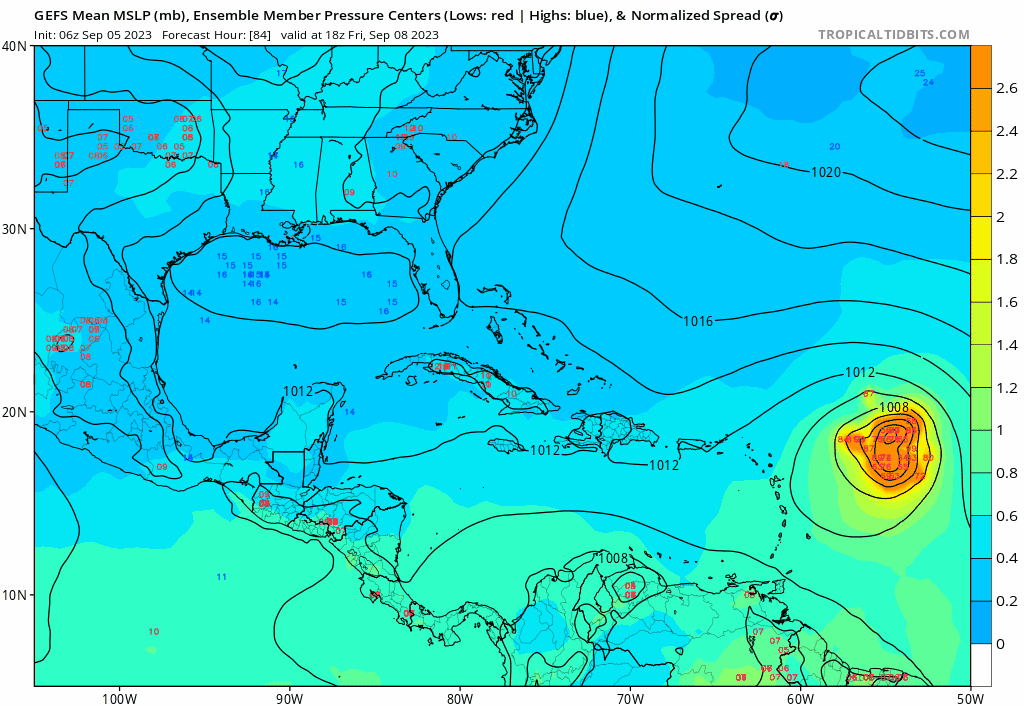
06z GEFS... Pretty large spread now...
0 likes
Hurricane Eye Experience: David 79, Irene 99, Frances 04, Jeanne 04, Wilma 05… Hurricane Brush Experience: Andrew 92, Erin 95, Floyd 99, Matthew 16, Irma 17, Ian 22, Nicole 22…
Who is online
Users browsing this forum: No registered users and 15 guests